Showing 578 items matching "healesville"
-
 Marysville & District Historical Society
Photograph (Item) - Black and white photograph, Fernshaw, c1900
An early black and white photograph taken at Fernshaw.An early black and white photograph taken at Fernshaw. Fernshaw was a rural township 63 km north-east of Melbourne and 10 km north-east of Healesville. Situated on the Watts River, near where a log had fallen making a convenient crossing, Fernshaw was settled in the 1860s. It provided good country for orchards and berry growing. The location was at the foot of Blacks Spur, with Mounts Juliet and Mondah rising on either side, providing spectacular scenery. There were nearby fern gullies giving rise to the name – ‘shaw’ is old English for thicket or wood. By 1875 Fernshaw had a post office (1865), two hotels, a school (1871) and stores. It was famed for its beauty, attracting tourists. In 1886 the Melbourne and Metropolitan Board of Works began work on the Watts River water catchment scheme – later to become Maroondah – and the Board obtained approval for the catchment country to be reserved and kept free of settlement. This required the removal of the Fernshaw township, which was completed by about 1890. The area was described in the 1903 Australian handbook:ARMSTRONG COLLECTION 42 STATION STREET/ SANDRINGHAM 3191/ TEL. (03) 9521 5442/ IAN M.L. ARMSTRONG OAMfernshaw, healesville, watts river, orchard, berry orchard, blacks spur, black spur, mount juliet, mount mondah, maroondah dam, victoria -
 Eltham District Historical Society Inc
Audio - Audio Recording, Jim Connor; Maroondah Aqueduct, 11 Jun 2022
This significant historical link in Melbourne’s water supply system is perhaps something we have taken for granted, or not even really noticed…it is just there! Built between 1886 and 1891 to transfer water from the Watts River near Healesville to the reservoir at Preston this aqueduct was 66 km in length and included open channels, tunnels and the use of inverted siphons to keep water flowing, to eventually service Melbourne and suburbs. At this meeting Jim Connor will talk about the challenges and achievements involved with this extraordinary project.1:09:10 duration Digital MP3 file; 23.7 MBaudio recording, eltham district historical society, meeting, society meeting, eltham, jim connor, maroondah aqueduct -
 Ringwood and District Historical Society
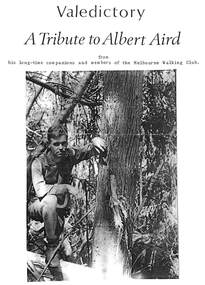
Pamphlet, Funeral Service Valedictory, Albert James Aird (1913-1995), descendant of Ringwood pioneering Aird family
Two and a half page A4 bifold tribute from companions and members of the Melbourne Walking Club with a photograph of Albert on front in a bush setting and loose page insert of order of Service. During Albert's time in the Walking Club he blazed the trail of many cross country walks around Healesville, Mount Donna Buang, Mount Juliet, Mount Buller and the Jamieson River. He was cared for in Donwood Nursing home, Croydon, at the end of his life. -
 Emerald Museum & Nobelius Heritage Park
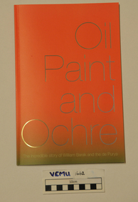
Book, Yarra Ranges Regional Museum, Oil Paint and Ochre, The incredible story of William Barak and the de Purys, 2015
This book tells the story of William Barak and the de Pury family, where descendants of both sides still live today. It also has national significance as a story that explores the complex, first generation negotiations between Aboriginal and European people. Also the establishment of Coranderrk Aborignal Station at Healesville and the growth of the wine industry in the Yarra Valley. William Barak was a Wurundjeri leader and the de Purys' were a wine making family. The book complemented and exhibition called Oil Paint and Ochre 29 Aug - 22 Nov 2015.Soft cover paperbackwilliam barak, de purys, corranderk -
 Eltham District Historical Society Inc
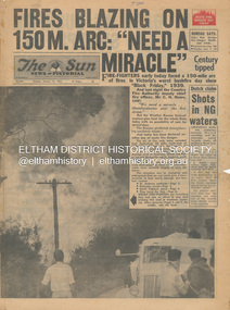
Newspaper - Newspaper articles, Sun News-Pictorial, Fires Blazing on 150M. Arc: "Need a Miracle", The Sun News-Pictorial, Tuesday, January 16, p1, 1962
Various news articles pertaining to the January 1962 Victorian bushfires in the Dandenong and Healesville districts which by second day had spread on to a 150 mile front fromDaylesford and Kinglake through to the Dandenongs. Specific Eltham Shire districts mentioned include Ninka Road, St. Andrews, Kinglake, Hurstbridge on page 2 • Fires Blazing on 150M. Arc: "Need a Miracle", p1 (Illust.) – Victoria’s worst bushfire day since “Black Friday,” 1939 • Night dash as bushfire sweeps by, p2 (Illust.) • Kalorama Saved: Fire 100 Ft. Away, p2 • Stay away, says police chief, p2 • The Tragedy of the Fires, p3 (Illust.) • Good save by firemen, p4 (Illust.) • S.E.C. Firemen Saved N. Yallourn, p4 • Cherry river of flame, p4 • From the fire front: Fire-fighters are bitten by snakes, p4 • They faced the fury, p6 (Illust.) • The ’39 Blaze, p6 • They fought and failed, p6 • Hills Aflame: 2nd Day, pp16-17 (Illust.) • Respite at Olinda HQ, p16 (Illust.) • Here is Ruin, p17 (Illust.) • This fireman had to work among piled up furniture … p32 (Illust.) tom fielding collection, victorian bushfires - 1962, victorian bushfires – 1962, black friday, victorian bushfires – 1939, c.h. howe, daylesford, country fire authority, dandenongs, yallourn, central gippsland, montrose, olinda, kalorama, healesville, st. andrews, hurstbridge, ninka road, kinglake, yarra glen, a.l. mccutcheon, st. andrews postmaster, eltham shire secretary, max watson, police commissioner porter, observatory road, mt. dandenong, whittlesea, one tree hill, sassafras, the basin, steel’s creek, ruby ryan, the basin progress hall, yaallourn, yallourn north, stet electricity commission (s.e.c.), hernes oak, mcdonalds track, florence milkins, lieutenant-colonel k. leggett, bonza view road, ringwood police station, michael o’connor, volunteers, fire damage - buildings -
 Marysville & District Historical Society
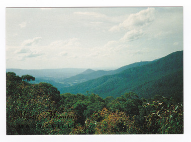
Postcard (item) - Colour postcard, Nucolorvue Productions Pty. Ltd, Mystic Mountains-Marysville, Pre 2009
A colour photograph of the view of the mountains surrounding Marysville in Victoria from Nicholl's Lookout.A colour photograph of the view of the mountains surrounding Marysville in Victoria from Nicholl's Lookout. The mountains surrounding Marysville are known as the Mystic Mountains and Nicoll's Lookout is on the Marysville-Wood's Point Road. The Marysville-Woods Point Road was originally part of the Yarra Track, constructed in the early 1860s to provide access between Healesville and the Woods Point Goldfields. Despite the steep terrain and engineering difficulties, the Yarra Track soon became a busy route used by pack horses, horse-drawn drays, and wagons. Today this sealed mountain road is a popular scenic drive between Marysville and Warburton. This postcard was produced by Nucolorvue Productions in Elwood, Victoria as a souvenir of Marysville.This postcard was produced by Nucolorvue Productions Pty. Ltd. as a souvenir of Marysville.NICHOLS LOOKOUT/ Marysville Victoria NU-COLOR-VUE/ AUSTRALIA'S NATIONAL POSTCARD COMPANY AFFIX/ STAMP/ HERE/ 17MA019/ NCV 9603 POSTCODE COPYRIGHT/ Nucolorvue Productions Pty. Ltd.,/ Telephone: (03) 560-1788/ Made in Australiamarysville, mystic mountains, nicholl's lookout, victoria, nucolorvue productions, postcard, souvenir, marysville-wood's point road, yarra track, healesville, mining, warburton -
 Marysville & District Historical Society
Photograph (Item) - Black and white photograph, Yarra Track Hotel, c1900
An early black and white photograph of a hotel along the Yarra Track.An early black and white photograph of a hotel along the Yarra Track. The Yarra Track is the former name of the gold fields road from Healesville to the Woods Point and Jordan Goldfields, in Victoria, Australia. A direct route via the Yarra River and the Great Divide was discovered by Rieck in September 1862 and became known as the Yarra Track. Early in 1863, the Victorian Government decided to construct a 193-kilometre (120 mile) road along the route. Its original width varied between 4 and 6 metres (12 and 20 feet), and was designed to accommodate horse-drawn vehicles. The Track involved the climbing of the Black Spur, descent into the Acheron Valley, and then through Marysville to the Cumberland where it followed the existing route. Unable to ascertain both the location and name of hotel.ARMSTRONG COLLECTION 42 STATION STREET/ SANDRINGHAM 3191/ TEL. (03) 9521 5442/ IAN M.L. ARMSTRONG OAMyarra track, healesville, wood's point, jordan goldfields, victoria, yarra river, great divide, reick, black spur, acheron valley, marysville, cumberland creek -
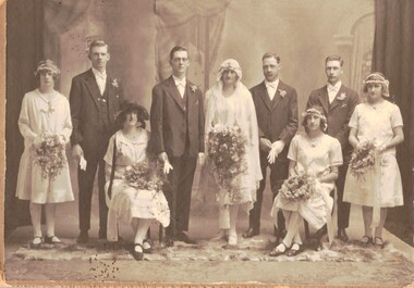 Whitehorse Historical Society Inc.
Photograph - Black and white photograph, Edwards/Hodge wedding 1926, 1926
Alfred Ernest Edwards was born 29/12/1903 in Mitcham and died 4/7/1967 at Forest Hill. he was a kiln worker at Geal's Pottery, Nunawading. Doris Gwendoline was born in 1905 at Surrey Hills and died on 15/3/1996 in a Healesville nursing home. She was 91. When Doris two her father died. Her mother remarried (Finger) and she had two step-sisters. Alfred (Alf) and Doris (Dorrie) had one child, Gwendoline Norma Edwards, born on 3/10/1930 at Forest Hill.Sepia studio photograph of the wedding of Alfred Ernest Edwards and Doris Gwendoline Hodge in 1926. There are nine people in the group. The bride and groom are in the centre; the man on the left is Alfred's brother Theodore and the woman seated on the left is Doris' Half -sister Jean (Finger)edwards, alfred ernest. hodge, doris gwendoline. edwards, theodore. finger, jean -
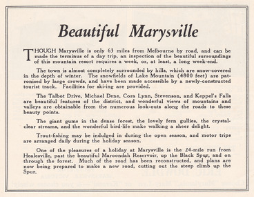 Marysville & District Historical Society
Ephemera (Item) - Advertisement, Beautiful Marysville, Unknown
An advertisement for Marysville and attractions in and around the local area.An advertisement for Marysville and attractions in and around the local area.marysville, victoria, lake mountain, talbot drive, lady talbot drive, michael dene, cora lynn falls, stevenson falls, steavenson falls, keppel's falls, healesville, maroondah reservoir, black spur -
 Marysville & District Historical Society
Photograph (Item) - Black and white photograph, The "Scandinavians' - (Deserted), c1900
An early black and white photograph of The Scandinavian's Hotel and Boarding House along the Yarra Track.An early black and white photograph of The Scandinavian's Hotel and Boarding House along the Yarra Track. The Yarra Track is the former name of the gold fields road from Healesville to the Woods Point and Jordan Goldfields, in Victoria, Australia. A direct route via the Yarra River and the Great Divide was discovered by Rieck in September 1862 and became known as the Yarra Track. Early in 1863, the Victorian Government decided to construct a 193-kilometre (120 mile) road along the route. Its original width varied between 4 and 6 metres (12 and 20 feet), and was designed to accommodate horse-drawn vehicles. The Track involved the climbing of the Black Spur, descent into the Acheron Valley, and then through Marysville to the Cumberland where it followed the existing route.ARMSTRONG COLLECTION 42 STATION STREET/ SANDRINGHAM 3191/ TEL. (03) 9521 5442/ IAN M.L. ARMSTRONG OAMthe scandinavians', yarra track, healesville, wood's point, jordan goldfields, victoria, yarra river, great divide, reick, black spur, acheron valley, marysville, cumberland creek -
 Marysville & District Historical Society
Photograph (Item) - Black and white photograph, Camp Opposite The "Scandinavians', c1900
An early black and white photograph of a camp which was opposite The Scandinavian's Hotel and Boarding House along the Yarra Track.An early black and white photograph of a camp which was opposite The Scandinavian's Hotel and Boarding House along the Yarra Track. The Yarra Track is the former name of the gold fields road from Healesville to the Woods Point and Jordan Goldfields, in Victoria, Australia. A direct route via the Yarra River and the Great Divide was discovered by Rieck in September 1862 and became known as the Yarra Track. Early in 1863, the Victorian Government decided to construct a 193-kilometre (120 mile) road along the route. Its original width varied between 4 and 6 metres (12 and 20 feet), and was designed to accommodate horse-drawn vehicles. The Track involved the climbing of the Black Spur, descent into the Acheron Valley, and then through Marysville to the Cumberland where it followed the existing route.ARMSTRONG COLLECTION 42 STATION STREET/ SANDRINGHAM 3191/ TEL. (03) 9521 5442/ IAN M.L. ARMSTRONG OAMthe scandinavians', yarra track, healesville, wood's point, jordan goldfields, victoria, yarra river, great divide, reick, black spur, acheron valley, marysville, cumberland creek -
 Ambulance Victoria Museum
Ambulance, Dodge, 1975, 1975
This vehicle was used for patient clinic runs between Morabbin and Kingston Hospital. It then was modified into an ambulance mobile communications vehicle. Found to be too small to fulfil this role it was later allocated to the Healesville State Emergency Service. It then returned to Ambulance Victoria where it was stored at Eltham for ten years. The vehicle was repaired mechanically by Bill Redpath in 2016 and repainted. It will be restored internally by AHSV members and former MICA paramedics to represent Car 208, Victoria's and Australia's first Mobile Intensive Care Ambulance (MICA). The AHSV holds some of the original equipment from Car 208 and this will be refitted into the Dodge.White Dodge Ambulancedodge, mica -
 Surrey Hills Historical Society Collection
Photograph, 'Graceburn', 17 Trafalgar Street, Mont Albert
Joseph Arthur Bailey, described as a manager in electoral rolls, came to Surrey Hills some time before 1903. He was born in Brighton in 1873 and died in Burwood in 1929 and is buried in Box Hill Cemetery. He was the son of George Bailey and Georgina Hardwick, who lived in Healesville for a time but 'retired' to Surrey Hills where they are listed at 'Claremont' in Mont Albert Road in 1919. Joseph married Eleanor Beatrice Greenhill in 1897. They had 3 sons - Rupert Aitken (who served in WW1); Kenneth Alan and Edwin George. Prior to living in Trafalgar Street they lived at 9 Victoria Crescent. A black and white photograph of a brick house in the californian bungalow style with a well-established garden, as viewed from one side.trafalgar street, graceburn, house names, 1919, californian bungalow, box hill cemetery, joseph arthur bailey, mrs eleanor beatrice bailey, miss eleanor beatrice greenhill, mr rupert aitken bailey, mr kenneth alan bailey, mr edwin george bailey -
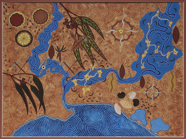 Merri-bek City Council
Acrylic on watercolour paper, Mandy Nicholson, Cultural Map of Melbourne, 2003
Primarily a painter, Mandy Nicholson also produces ceramics, carvings, murals, prints, designs and children’s clothing. Born in 1975, Nicholson was raised in Healesville and belongs to the Wurundjeri-willam (Woiwurrung language) clan of the Kulin Nation. Mandy’s paintings often represent important cultural rituals and are executed in her distinct graphic style using the traditional motifs of her people blended with contemporary interpretation. Cultural Map of Melbourne shows significant sites across Melbourne. These include scar trees, corroboree trees, stone quarries, bush tucker sites, significant rivers, fresh water wells and traditional campsites. -
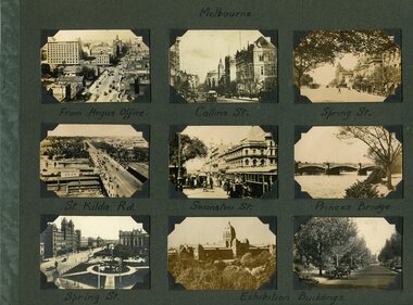 Melbourne Tram Museum
Photograph - Photo card Melbourne album sheets 1920c
Part of an album of photo cards - cigarette card size - that depicted Melbourne and other country towns c1920. Sheet 1 - Melbourne - Elizabeth St, Collins St, Spring St, St Kilda Rd, Swanston St, Princes Bridge and Exhibition buildings. Sheet 2 - Healesville, Lorne, Brighton, Albury, Bendigo, Woori Yallock and Queenscliff - three cards have been removed prior to acquisition. Sheet 3 - Queen Victoria Gardens, Alexandra Avenue, Exhibition Gardens, St Kilda Road, Botanic Gardens - three cards have been removed prior to acquisition.Set of three album sheets containing up to 9 small printed photos on each sheet of Melbourne and some country towns.melbourne, victoria, tramways, gardens -
 Ballarat Heritage Services
Ceramic, Glazed vase by Tom Nestor, c1986
Tom NESTOR Tom Nestor studied a Diploma of Fine Art at Ballarat College of Advanced Education (later Federation University) in 1980, 1981 and 1982 with the intending to be a secondary teacher. Instead, he opened his own ceramics studio in Bald Hills at his parents property near Creswick. He worked for potteries in Albury and Healesville as well as Old Ballarat Pottery as a production thrower. In 1985 he moved to Belgrave where he continued to work producing kitchenware and garden pots till mid 1986. Works may be marked with an impressed stamp as on this vase "Tom Nestor Bald Hills Handcrafted"Glazed vase with cobalt blue leaves.ceramics, australian studio pottery, tom nestor, bald hills pottery -
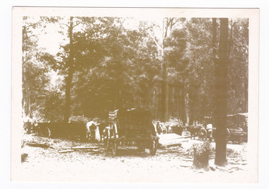 Marysville & District Historical Society
Postcard (item) - Black and white postcard, Marysville & District Historical Society Inc, Bullock Teams at the Dump, Woods Point Road, 1993
A black and white photograph of bullock teams at the Log Dump at on the Wood's Point Road.A black and white photograph of bullock teams at the Dump at on the Wood's Point Road. The Marysville-Woods Point Road was originally part of the Yarra Track, constructed in the early 1860s to provide access between Healesville and the Woods Point Goldfields. Despite the steep terrain and engineering difficulties, the Yarra Track soon became a busy route used by pack horses, horse-drawn drays, and wagons. Today this sealed mountain road is a popular scenic drive between Marysville and Warburton. This postcard was produced by the Marysville Historical Society as a souvenir of Marysville.YESTERYEAR POSTCARDS AFFIX/ STAMP/ HERE BULLOCK TEAMS AT THE DUMP,/ WOODS POINT ROAD. C Marysville Historical Society, 1993marysville, bullock teams, woods point road, victoria, marysville historical society, postcard, souvenir, yesteryear postcards, marysville-wood's point road, yarra track, healesville, mining, timber mills, warburton -
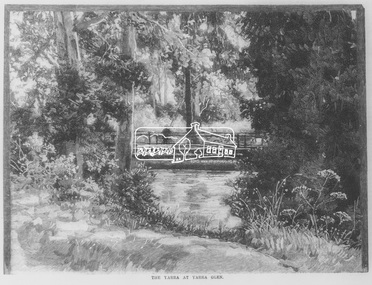 Eltham District Historical Society Inc
Negative - Photograph, Australasian Sketcher, The Yarra at Yarra Glen, 1889
"As the train on its journey from Melbourne to Healesville crosses the Yarra-flats, many glimpses are caught of the Yarra, sometimes between large belts of gumtrees, and splashing over boulders with is bosum covered with bubbles, dancing with sunlight, and racing each other until lost in the dark shadows of the wattles. Another turn catches it in a sombre mood, stealing slowly beneath some rustic bridge, whereon stands a patient fisherman waiting for a fish, which if the bait be correct, comes pretty frequently. Our illustration depicts one of these pretty nooks, and a very good idea is given of our picturesque river before it is polluted and turned into a sewer at Prince's Bridge."This photo forms part of a collection of photographs gathered by the Shire of Eltham for their centenary project book,"Pioneers and Painters: 100 years of the Shire of Eltham" by Alan Marshall (1971). The collection of over 500 images is held in partnership between Eltham District Historical Society and Yarra Plenty Regional Library (Eltham Library) and is now formally known as the 'The Shire of Eltham Pioneers Photograph Collection.' It is significant in being the first community sourced collection representing the places and people of the Shire's first one hundred years.Digital image 35mm Negativesepp, shire of eltham pioneers photograph collection, yarra glen, steels creek, cave hill -
 Mount Evelyn History Group
Book Railways of the Yarra Valley, Nick Anchen, Railways of the Yarra Valley, 2010
Railways of the Yarra Valley takes you on a nostalgic journey back in time to when the Victorian Railways branch lines and the ingenious bush tramways were the lifeblood of isolated rural communities. This book examines the much loved Warburton and Healesville railways, along with the fascinating Powelltown, Britannia Creek and Warburton tramway systems, all of which were instrumental in making the Yarra Valley Victoria�s most prosperous timber region. Featuring a superb array of colour and b&w images, most never before published, complimented by interesting and informative text, plus stories from those who saw and worked the lines. Soft bound, 96 pages. (from website)Coloured cover soft back book -
Mount Evelyn History Group
Book Railways of the Yarra Valley, Nick Anchen, Railways of the Yarra Valley, 2010
Railways of the Yarra Valley takes you on a nostalgic journey back in time to when the Victorian Railways branch lines and the ingenious bush tramways were the lifeblood of isolated rural communities. This book examines the much loved Warburton and Healesville railways, along with the fascinating Powelltown, Britannia Creek and Warburton tramway systems, all of which were instrumental in making the Yarra Valley Victoria�s most prosperous timber region. Featuring a superb array of colour and b&w images, most never before published, complimented by interesting and informative text, plus stories from those who saw and worked the lines. Soft bound, 96 pages. (from website)Coloured soft back book -
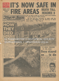 Eltham District Historical Society Inc
Newspaper - Newspaper articles, Sun News-Pictorial, It's Now Safe in Fire Areas; Death Toll Reacxhes 8, The Sun News-Pictorial, Thursday, January 18, p1, 1962
Various news articles pertaining to the January 1962 Victorian bushfires in the Dandenong and Healesville districts which by the third day had encompassed large areas of the State. Specific Eltham Shire districts mentioned include Warrandyte on page 1, St. Andrews and Smith’s Gully on page 2, St. Andrews on page 3 and 43, Panton Hill and Warrandyte on p23 and Hurstbridge on page 44 • It's Now Safe in Fire Areas; Death Toll Reaches 8, p1 (Illust.) • How they died, pp1-2 • It was “heaven” in the bush … Boys stayed on . . . to die, pp1-2 (Illust.) • Towns take stock as danger drops, p2 • £5400 to the relief fund, p2 • Fire now threat to Otways, p2 • Pensioners lose all, p2 • “…If Only The Rain Had Come” … and then it came to town, p3 (Illust.) • Our best rain since May • It halted at Grandma’s front gate, p5 (Illust.) • Now that the rain has come; It’s time for the clean-up, p6 • Wisps of smoke where flames danced, p7 • Charitry’s a loser, p7 • War Service homes claim, p7 • Help’s on way, p7 (Illust.) • Came with their gifts …, p7 • Fire summons for youth; “sparked the rest”, p9 • Three gaoled, p9 • They had to camp out at Wye River, p9 (Illust.) • “Probe Fires” – Stoneham, p9 • The Fourth Day: Scorched Earth!, pp22-23 (Illust.) • This home was saved but - , p22 (Illust.) • Relief Centre, p23 (Illust.) • Homeless, p23 (Illust.) • So little was left, p43 (Illust.) • Tommy saved his cat, p43 (Illust.) • Some were lucky … and some were tired, p44 (Illust.) tom fielding collection, victorian bushfires - 1962, victorian bushfires – 1962, ronald ockwell, geoffrey ockwell, woori yallock, william ockwell, leslie ockwell, linda may ockwell, black friday, victorian bushfires – 1939, warrandyte, arthur brown, harold vernon betton, bloom road, william smith, olinda, bushfire relief fund, yarra glen, healesville, railway line, st. andrews, smith’s gully, otway ranges, eric watts, edith varty, inverness road, mt. evelyn, wye river, panton hil, heather sullivan, warrandyte hall, montrose, kalorama, mrs e. tucker, shirley tucker, margaret tucker, joane tucker, roger tucker, trevor tucker, ann quinton, tom dunstan, hurstbridge hall -
 Marysville & District Historical Society
Painting (Item) - Oil painting, Isaac Whitehead, A spring morning near Fernshaw 1880, 1880
A copy of an early oil painting of Fernshaw in Victoria.A copy of an early oil painting of Fernshaw in Victoria by Isaac Whitehead. Isaac Whitehead (1819–1881) was an Irish-Australian artist who worked in watercolour and pastel. He was also a picture framer and art promoter. It is believed that Isaaz Whitehead emigrated to Australia with his family in either 1853 or 1858. Isaac Whitehead died at his home 50 Punt Road, Prahran, Melbourne, on 21 April 1881. Isaac Whitehead had established himself as the foremost picture framer in Melbourne by 1860, known for his highly ornate frames with floral decorations. Among the clients of his framing business were Louis Buvelot, Nicholas Chevalier, and Eugene von Guérard. In his own paintings, he painted a number of scenes of the forests of Gippsland, Victoria. His work focused on the rich landscapes with trees and ferns, with a high degree of botanical detail. His work won him two medals and his work was posthumously exhibited at 1884 Victorian Jubilee Exhibition, the 1886 London Colonial and Indian Exhibition, and the 1888 Melbourne Centennial Intercolonial Exhibition. Fernshaw was a rural township 63 km northeast of Melbourne and 10 km northeast of Healesville. Situated on the Watts River, near where a log had fallen making a convenient crossing, Fernshaw was settled in the 1860s. It provided good country for orchards and berry growing. The location was at the foot of Blacks Spur, with Mounts Juliet and Mondah rising on either side, providing spectacular scenery. There were nearby fern gullies giving rise to the name – ‘shaw’ is old English for thicket or wood. By 1875 Fernshaw had a post office (1865), two hotels, a school (1871), and stores. It was famed for its beauty, attracting tourists. In 1886 the Melbourne and Metropolitan Board of Works began work on the Watts River water catchment scheme – later to become Maroondah – and the Board obtained approval for the catchment country to be reserved and kept free of settlement. This required the removal of the Fernshaw township, which was completed by about 1890.isaac whitehead, fernshaw, victoria, louis buvelot, nicholas chevalier, eugene von guerard, gippsland, victorian jubilee exhibition, london colonial and indian exhibition, melbourne centennial intercolonial exhibition, watts river, healesville, blacks spur, mount juliet, mount mondah -
 Ringwood and District Historical Society
Photograph, Group around new tree Wandin North near E. Reads present home
Photograph missing from archives after having been scanned and catalogued as follows, however no clear information on location or date:Written on mounting sheet above the photograph, "R.B. Lord, Dolly Lord, Eileen Mitchell, Dot Mitchell, Ethel Mao, James Mitchell??? (Scotty) (around tree), Mrs. Chris Russell, Mrs. Ruby Lydster and child and lady unknown, (Thos Tuadion?) Jean Mitchell". Written on back of mounting sheet, "Please return to Mrs. A. Cooke, Smith Street, Healesville. Tree planted for Harry Lord, Main Road, Wandin North, near E. Reads present home". -
 Melbourne Water
Photographic View Book, The Melbourne & Metropolitan Board of Works - Water Supply, Sewerage etc. ...Photographic Views, 1908
In 1891 The Melbourne and Metropolitan Board of Works (MMBW) was formed and became responsible for Melbourne's water supply. Melbourne had grown to a city of half a million people. To provide water to this rapidly growing city (especially the eastern suburbs), and to supplement the 1857 Yan Yean Reservoir, Melbourne's first water supply, the Watts River (near Healesville) was tapped. It supplied water to Melbourne, via the Maroondah aqueduct. In May 1892 the MMBW's first engineer-in-chief, Mr William Thwaites began construction on Melbourne's sewerage system. A treatment farm was built at Werribee and a pumping station was built at Spotswood (now the site of the Scienceworks Museum) to send the city's waste to Werribee. The first Melbourne homes were connected to the sewerage system in 1897. This book showcases the MMBW's infrastructure achievements and documents costs, requirements and key personnel involved in the development of the water supply and sewerage schemes.The introduction states "The water supply sources and headworks are in many cases situated in remote places and the sewerage works are chiefly underground. The Board has therefore resolved that these photographs of some of the scenes and works should be collected and bound for general information. August 1908" This book is in excellent condition and provides a detailed insight into the previous 17 years of work and the Board personnel of the MMBW leading up to 1908. It is of historical importance to the history of Melbourne for the photographic documents of places that were not generally open to the public, and for Melbourne Water in its detailed history of the MMBW in the early twentieth century. Photographic view book with hard khaki coloured cardboard cover and blue fabric binding. 120 Pages. Glossy paper with black and white plates and text about the MMBW, and scenic views and places of interest in association with the MMBW. The Melbourne & Metropolitan Board of Works - Water Supply, Sewerage etc. ...Photographic Views...mmbw, board members, sewerage, water supply, historic views, photographs -
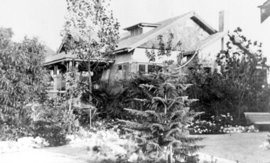
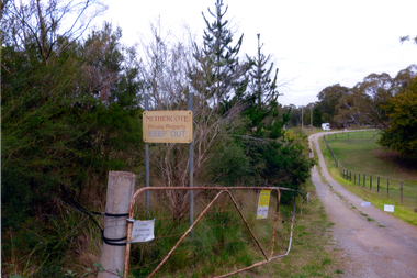 Whitehorse Historical Society Inc.
Photograph, Nethercote property, 2012
The land photographed is widely known as Nethercotes. In 1920 Arthur Nethercote, import agent, bought the land which was situated in Boronia Road near Dandenong Creek. Originally a flower farm, the Nethercotes became poultry farmers. The property contained a five-roomed weatherboard house which they called Weston Favell. Dated before 1883 (from newspapers found in the ceiling) it is the more dilapidated house photographed. The other house called Greenways was built for a son. Gerald Letts bought the property and when he died the Board of Works purchased the land, intending to use it as part of the proposed Healesville Freeway, meanwhile the property was leased to the Box Hill Institute's equine department. In 2013 the Board of Works announced that the freeway would not go ahead.Coloured photographs of the two houses and land at the Nethercote property, Vermont. Now owned by the board of Works and leased to the Box Hill Institute.nethercote property, vermont, board of works, proposed healesville freeway, box hill institute -
Bialik College
Flyer (item) - Ngarrgee, 2020
Invitations sent to school community and running sheets for Ngarrgee events 2020- to acknowledge the traditional owners of the land, Rosh Hashanah, and to welcome the new Year 12 leadership cohort, the Mazkirut. 'Ngarrgee' is a Wurundjeri word meaning 'coming together'. The school's RAP Committee advised in 2020: 'Following on from the very successful Welcome to Country smoking ceremony in 2019, which was appropriately aligned with Rosh Hashanah, we are continuing with this new tradition by hosting the same event on Tuesday 15 September at 8.00pm via the ZOOM platform. Adapting to current circumstances, the smoking ceremony will be led by Murrundindi, Ngurungaeta (Head Man) for the Wurundjeri clan, from his property in Healesville. This year, the event will also incorporate the Mazkirut Induction ceremony.' Please contact [email protected] to request access to this record. event, celebration, year 12, 2020s -
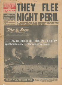 Eltham District Historical Society Inc
Newspaper - Newspaper articles, Sun News-Pictorial, They Flee Night Peril, The Sun News-Pictorial, Wednesday, January 17, p1, 1962
Various news articles pertaining to the January 1962 Victorian bushfires in the Dandenong and Healesville districts which by the third day had encompassed large areas of the State. Specific Eltham Shire districts mentioned include Panton Hill and Hurstbridge on page 1, Warrandyte on page 2, 3, 4 and 5, Hurstbridge, Smith’s Gully, Kinglake on page 3 and 4, Strathewen, Kangaroo Ground, Panton Hill, St. Andrews, Smith’s Gully on page 4 and Pound Bend, Smith’s Gully and Warrandyte on pages 20-21 • They Flee Night Peril, p1 (Illust.) • Their grim picnic; A flash fire strikes, p2 (Illust.) • Night of terror as towns quitted, p3 • Fought till he dropped, p3 (Illust.) • Rain in fire area, p3 • Wye River town goes, p3 • Black Friday Hero Dies In Fire; with wife, grandsons, p4 • Surrounded!, p4 (Illust.) • Main street houses ablaze, p4 • Hurstbridge is evacuated, p4 • Scores jump in river at Warrandyte, p5 • Hills people leave homes, p5 • “Fire” cry at Parlt., p5 • Blind – he’s safe now, p5 (Illust.) • Police Chief Runs Battle, p7 • From Fire Front: Hospital treats 34, p7 • Firms send help, p7 • Tragedy and Ruin: Third Day; Ferntree Gully; Warrandyte; Pound Bend; Smiths Gully; Escape for 18, pp20-21 (Illust.) • Church was a haven for the hurt, weary, p39 (Illust.) • A home is lost, p40 (Illust.) tom fielding collection, victorian bushfires - 1962, victorian bushfires – 1962, panton hill, hurstbridge, five ways crossroads, warrandyte south, dandenongs, upwey, mt. evelyn, monbulk, olinda, sassafras, st. andrews, warrandyte, christmas hills, yarra river, mitcham, whitehorse roiad, donvale, park orchards, metropolitan fire chief, w.t. aldridge, loughnan’s hill, ringwood, woori yallock, leslie ockwell, linda ockwell, kalorama, healesville, daylesford, fire damage – buildings, wye river, portland, eganstown, ballarat, sherbrooke park forest, forest commission headquarters, kallista, r.t. seaton, montrose, yallourn, central gippsland, smith’s creek, black friday, geoffrey ockwell, ronald ockwell, preston town hall, e.j. tenner, strathewen, kangaroo ground, eric farnsworth, adele farnsworth, robin farnsworth, roy cleland, ann cleland, belgrave, sassfras, kaloramalice commissioner porter, mansfield, box hill hospital, pound bend, ferntree gully, ferntree gully state school, w. carew, ann quinton -
Marysville & District Historical Society
Article (item) - Magazine Article, Coranderrk-A Station Never a Mission, Unknown
A magazine article on the history of Coranderrk based on a historical component of a survey of Coranderrk Station.A magazine article on the history of Coranderrk based on a historical component of a survey of Coranderrk Station.coranderrk, coranderrk station, dr marie hansen fels, healesville and district aboriginal community, john green, healesville, acheron river, mohican, native police corps, merri creek, closer settlement act, badger creek, hops, cattle, royal commission of 1877, board of enquiry 1881, lake tyers