Showing 610 items
matching pressure
-
 Flagstaff Hill Maritime Museum and Village
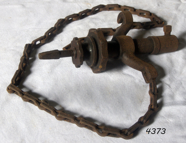
Tool - Chain Drill Attachment, Millers Falls Co, 1900-1931
An auxiliary tool for use with a breast drill or bit brace, when extra power is needed, or where pressure cannot be easily applied. The drill is automatically fed into the work by an adjustable friction feed which is automatically regulated by the resistance the drill encounters. These were made to fit on breast drills, and used for drilling metal, particularly round sections like a pipe. The chain is run around the object being drilled and gradually tightens as the hole is drilled, maintaining pressure while being a bit easier on the operator. Millers Falls Co. is a tool manufacturing company originally based in Millers Falls, Massachusetts, USA. It was established in Greenfield, Massachusetts in 1868 as Gunn & Amidon by Levi J. Gunn and Charles H. Amidon. Gunn and Amidon, along with a third partner, Henry L. Pratt built a factory in the north of Greenfield. After the Greenfield factory burned down, the company was reorganized as the Millers Falls Manufacturing Co. It merged with Backus Vise Co. in 1872 to form Millers Falls Co. In 1931 Millers Falls tools purchased the majority of the shares of Goodell-Pratt tools and merged with that manufacturer in 1932. In 1962 the company was acquired by Ingersoll Rand. In 1982, Ingersoll Rand sold the Millers Falls business to the newly created Millers Falls Tool Co. The company was head quartered in Alpha, New Jersey. Since 2002 the company trademark has belonged to Hangzhou Great Star Industrial, of Hangzhou, China. The item is associated with a tool manufacturing company established in the mid-19th century that pioneered the development of many types of tools used in many differing trades. The company grew to become a major supplier of tools around the world and today its tools that were produced during the mid-19th and early 20th centuries are now collectable items. Drill attachment with chain No 717 from 1925 catalogue 1/2 socket hole Millers Falls, Massachusettsflagstaff hill, warrnambool, flagstaff hill maritime museum, maritime museum, shipwreck coast, flagstaff hill maritime village, great ocean road, chain drill, mast drill, millers falls, drilling attachment, drilling tools -
 Tarnagulla History Archive
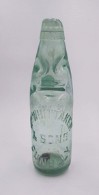
Codd Bottle - Whittaker & Sons, Lemonade, Dunolly
David Gordon Collection. A Codd-neck bottle is a type of bottle used for carbonated drinks. Hiram Codd, an English engineer invented a successful process that he patented as “Codd’s patented globe stopper bottle” in 1872. This type of bottle has a closing design in which a glass marble is held against a rubber seal, which sits within a recess in the lip. The Codd-neck bottle was designed and manufactured with thick glass to withstand internal pressure, and a chamber to enclose a marble and a rubber washer in the neck. The bottles are filled upside down, and pressure of the gas in the bottle forced the marble against the washer, sealing in the carbonation. The bottle is pinched into a special shape to provide a chamber into which the marble is pushed to open the bottle. This prevents the marble from blocking the neck as the drink is poured. The bottles were regularly produced for many decades, but gradually declined in usage. Since children smashed the bottles to retrieve the marbles, vintage bottles are relatively scarce and have become collector items, particularly in the UK. William Whittaker's son Joseph Whittaker operated a cordial factory at Tarnagulla for many years. It was located at the southern end of Commercial Road, and was the last business premises on the eastern side of the road. Joseph Whittaker was a leading citizen at Tarnagulla for many years, and was a leading supporter of sporting activities including cricket and rifle clubs, as well as a strong patron of the fire brigade. He was known by some as Ginger Beer Joe. -
 Parks Victoria - Gabo Island Lightstation
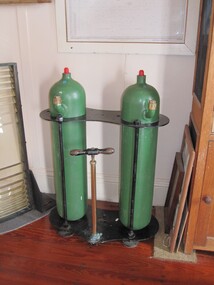
Tanks, kerosene vaporiser
The heavy twin tanks formerly contained vaporised kerosene which was used as a fuel to light the lantern. Kerosene became available in the 1860s as the oil industry in the United States developed, and vaporised kerosene soon became the most common system of illumination. The kerosene vapour lamp was perfected by Chance Bros. for burning the light in their renowned lenses. The system involved vaporising kerosene under pressure and mixing it with air and then burning the vapour to heat an incandescent mantle. The lamp had to be watched throughout the night in case a mantle broke, and the tanks needed to be maintained by hand-pumping each hour or so. Kerosene tanks like these were developed in the early twentieth century, and kerosene as a fuel was phased out by electricity, with the last kerosene system in Australia eventually replaced in 1985. The wick lamp in Gabo Island’s light was altered to a vaporised incandescent kerosene mantle burner in 1909. They would have been in use until 1935, when the light was electrified and the original first-order lens was replaced by a fourth-order lens. The Gabo Island tanks, which are presumed to be those used in the lighthouse between 1909 and 1935, are not attached to the optical apparatus and are no longer in the lighthouse. They are also missing the pressure gauges that were formerly attached to the top of each cylinder. Cape Schanck has a pair of unattached tanks, which are not historically associated with the lighthouse. Point Hicks has an iron stand that formerly supported its lighthouse oil tanks. Despite their lack of intactness, the Gabo Island tanks have first level contributory significance for their provenance to the lightstation and historic association with the lantern’s original Chance Brothers first order lens, which was removed in 1935Two large green cylinders standing in a metal frame. There is also a pumping mechanism attached to the stand with a wooden handle. -
 The Beechworth Burke Museum
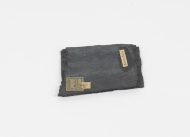
Geological specimen - Slate (Metamorphic), Unknown
This particular specimen was found in the Moorabool Slate quarries in Victoria. The Moorabool Slate quarries was established in the 1860’s by a company of Welshmen with a crew of six who purchased land by the riverside to mine for slate. Under the promise of adding to existing recourses the crew mined the slate which was used for paving and roofing. Slate is a fine-grained, low-grade metamorphic rock that is formed by the transformation of mudstone, shale or sometimes volcanic ash under low pressure and temperatures. It dark colour is due to carbonaceous material or to finely divided iron sulphide. It is believed that Evan Rowlands and Theophilus Williams of Ballarat were the first to discover the slate veins. Slate is a one of the most common natural stones in general use. Being used as paving, flooring, roofing and more. However, its history of being mined in Australia is not common as it is considered that the best places to mine slate is Spain and parts of the United Kingdom. This specimen is part of a larger collection of geological and mineral specimens collected from around Australia (and some parts of the world) and donated to the Burke Museum between 1868-1880. A large percentage of these specimens were collected in Victoria as part of the Geological Survey of Victoria that begun in 1852 (in response to the Gold Rush) to study and map the geology of Victoria. Collecting geological specimens was an important part of mapping and understanding the scientific makeup of the earth. Many of these specimens were sent to research and collecting organisations across Australia, including the Burke Museum, to educate and encourage further study.A somewhat rectangular foliated metamorphic rock composed of quartz, sericite and minerals from the chlorite group that make up the compounds of slate. The rock is dark grey almost black.Geological survey / R S / Loc Moorabool /Slate quarries / 1/4 sheet | 78 | Roofing Slate /burke museum, beechworth, geological, slate, metamorphic, slate (metamorphic), geological specimen, slate specimen, indigo shire -
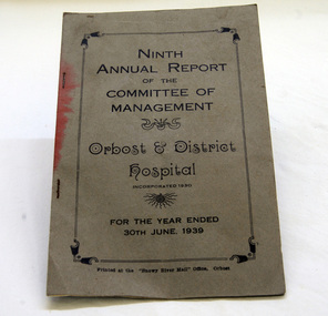 Orbost & District Historical Society
book, 1939
The Committee of Management held monthly meetings and "the members were conscientious in their attendance". 1938/1939 were busy years for the Orbost Hospital as there was a serious outbreak of poliomyelitis and some cases had to be sent on to Sale. There was also pressure from Dr Nettleton to begin a garbage collection in the town to clean up the town As the polio epidemic abated, diptheria took over and Dr Nettleton urged the shire to fund a further free immunisation campaign. In February, 1939t here were major bush fires in the district and the fire came within 300 yards of the Orbost Hospital. (info. from Orbost Hospital History, Personalities and Stories by Margaret Hollands)The Orbost Hospital was completed by the end of October 1929 after more than twenty years of agitation and preparation. Orbost is an isolated town and the importance of the medical service in the community is immense. This report is a reminder of its early history.A small book - 9th annual report of the Management Committee of Orbost & District Hospital, incorporated 1930. In black print inside rectangular border is title plus "For the Year Ended 30th June, 1939."orbost-hospital report-orbost-hospital-committee-of-management -
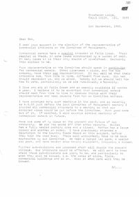 Falls Creek Historical Society
Document - Orest Frueauf Letter - Support as Representative Of Commercial Interests On Committee Of Management, 01.09.1968
Bob (Herman) Hymans (a former member of the Royal Netherlands Navy) was born in Bloemendaal, Holland on 30th September 1922. During World War II he fought against the Japanese in the Dutch East Indies (now Indonesia) and was imprisoned in Changi and on the Burma Railway. After gaining qualifications as a Ski Instructor, Bob arrived in Falls Creek in July 1950. Working as an Instructor and Supervisor at Bogong Lodge, Bob decided his future was in accommodation. He was successful in negotiating an indenture for land from the State Electricity Commission (SEC). It took Bob two years to build his Grand Coeur Chalet but, tragically, it was burned down in August 1961. Bob also built the first Chairlift in Australia. This was a single chairlift and the structure was built from wooden electricity poles. He was constantly full of new ideas and proposals for the village. Bob Hymans die on 7th July 2007. This Collection of documents and letters tells the story of Bob's endeavours to develop Falls Creek into the ski village it is today.This item is significant because it documents actions taken by the Falls Creek Tourist Area Management Committee in their role overseeing the Tourist Area.Letter from Orest Frueauf to Bob Hymans regarding the upcoming Management Committee election. He requested Bob's support in Orest's quest to be elected as the representative for those with commercial interests in Falls Creek. Orest raised concerns related to the release of further subdivisions in the Village which would double its size and put pressure on sewerage, water supply and roads. Other ongoing issues he referred to included oversnow transport, new tows, fire protection, finance, internal roads, search and rescue, publicity and booking arrangements. Orest believed that those with commercial interests needed to have a common approach and reliable representation on the Management Committee.falls creek tourist area management committee, falls creek administration, bob hymans -
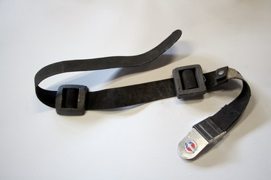 Seaworks Maritime Museum
Weight Belt, Survivair U.S. Divers, February 1974
Black weight belt with two stone weights with stainless steel Survivair U.S. Divers/U/Permissable supplied-air respirator/type C/pressure demand class United States Department of Labor/ MSHA U.S Department of Health Education NIOBH/ Mind Safety and Health Administration National Institute of Occupational Health and Safety Approval No. TC-19C-68/ Issued to Survivairs division. U.S. ... co Santa Anna./ MSHA NISOH approval issued 10/ Survivair's division U.S. Divers co./ February 1974 -
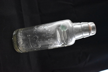 Warrnambool and District Historical Society Inc.
Bottle, Webb Bros Port Fairy, Early 20th century
This is a marble stopper bottle from the Port Fairy aerated waters factory of the Webb brothers. A marble stopper bottle was filled upside down so that as soon as the filling stopped the stopper was forced down to seal the bottle against the rubber ring. Pressure inside the bottle would keep the marble pressed against the top of the bottle. To open the bottle the marble was pressed down where it would fall into the neck chamber below. The marble would stay inside the chamber when the bottle was tilted up for drinking. The Webb brothers operated the Port Fairy Aerated Water and Cordial Factory in William Street (no 29) in the late 19th and early 20th centuries. This bottle is of interest as an example of a marble stopper bottle from the aerated waters factory of the Webb brothers in Port Fairy. Cordial manufacturing was an important industry in Warrnambool and district for over 100 yearsThis is a marble stopper glass bottle. It has a rounded base with a rounded body tapering to a deeply-indented section which forms a narrow neck chamber. The top is rounded moulded glass with an opening. The green marble is loose inside the neck chamber and the rubber ring has been displaced and is at the bottom of the bottle. There is some discolouration inside the bottle from the original contents.‘Webb Bros. Aerated Waters Port Fairy’ cordial manufacturing in warrnambool district -
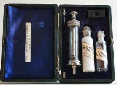 Geoffrey Kaye Museum of Anaesthetic History
Kit, Snake bite, Felton Grimwade & Co
Prior to the first antivenom development in Australia, many of the snake men had a vast array of snakebite remedies they either used for themselves in the case of bites or pedaled to the public. Treatments such as ammonia, strychnine, chlorinated lime, potassium permanganate, suction caps, alcohol, gunpowder, petrol, toad urine, iodide swabs and pig face plant juice were some that were used and sold. The first antivenom produced in Australia was in 1930 for tiger snake bites. Subsequently, in response to public pressure, other antivenoms were produced. Taipan, 1955; Brown snake, 1956; Death Adder, 1958; Papuan black snake, 1959; Sea snake, 1961; and the polyvalent, 1962.Black box with hinged opening and gold leaf printed text on the top. Inside the box is lined with blue satin and velvet, and contains one (1) syringe with glass chamber and metal plunger and black rubber stopper, one (1) glass bottle with a label stating it contains chloride of lime, one (1) glass bottle with a label stating it contains pure alcohol and two (2) needles with metal connectors, one of which is broken. There is also a small wooden block with a groove in the top of it.Gold lettering on top of box: CHLORIDE OF LIME ANTIDOTE / FOR / SNAKE BITE / FELTON GRIMWADE & CO. / MELBOURNE.hydrochloride lime, alcohol, antidote, venom, snake bite -
 Bendigo Historical Society Inc.
Audio - Making Tracks, c1980s
Bendigo Workshops is a railway workshop in Bendigo, Victoria, Australia. It is located in the north of the city beside the junction of the Swan Hill and Deniliquin railway lines. The site covers 10.3 hectares of land and has 31 separate buildings, including a 10,000 sqm main workshop building and six kms of railway track. The workshops were opened in November 1917 by the Victorian Railways. It opened in response to political pressures from provincial groups for decentralization, with the Victorian Railways preferring the cheaper option of expanding the existing Newport Workshops in suburban Melbourne. The 1980s were a time of restructuring, and on the breakup of the Victorian Railways the workshops passed to the State Transport Authority and then the Public Transport Corporation.Three Audio Files - by David Bennet, Davis Moon and Kevin Whelan who worked at the Bendigo Railway Workshops. The three share their working life memories history, bendigo, bendigo railway workshops -
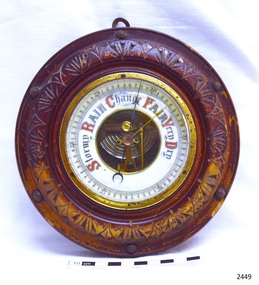 Flagstaff Hill Maritime Museum and Village
Instrument - Barometer, Early 20th century
A barometer is an instrument used for measuring atmosphere pressure thus determining weather changes.The first apparatus generally accepted as a barometer was that set up in Florence in 1644 by Evangelista Torricelli (1608–1647), a mathematician and physicist. Torricelli filled a glass tube with mercury, sealed it at one end, and inverted it with its open end in a dish of mercury. The level always fell a short way down the tube, then settled at a height of about thirty inches. He concluded correctly that the mercury column was sustained by the weight of the air pressing on the open surface of mercury, and further experiments convinced him that the space above the mercury in the tube was a vacuum. He noted that the level rose and fell with changing temperature, but he was unable to use his apparatus to measure variations in the weight of the atmosphere because he had not foreseen that temperature would affect the level of the mercury. News of this experiment circulated quickly among European scientists, who hastened to replicate the experiment. Torricelli's conclusions were not universally accepted because some disputed whether the air had weight, while both Aristotle and the Catholic Church denied the possibility of a vacuum. In France, the philosopher René Descartes (1596–1650) seems to have been the first person, probably in 1647, to attach a graduated scale to the tube so that he could record any changes attributable to the weather. At around this time Duke Ferdinand II of Tuscany organized the first short-lived meteorological network among scientists in other Italian cities, gathering observations of pressure, temperature, humidity, wind direction, and state of the sky.Theis barometer is an example of a household item from the early 20th century, used to determine the day's weather. The barometer is significant as an aid to human social, material and scientific development.Barometer, round, brass housing inset into carved wooden casing (lacquer mostly worn off). Decorative lettering for weather conditions "Stormy, Rain, Change, Fair, Very Dry". Workings are visible through opening in centre of dial. Indicator needle and another adjustable needle . Hook screwed into back of case.flagstaff hill, warrnambool, shipwrecked coast, flagstaff hill maritime museum, maritime museum, shipwreck coast, flagstaff hill maritime village, great ocean road, barometer, scientific instrument, weather forcasting instrument, weather gauge -
 Puffing Billy Railway
Heinrici Hot Air Motor, 1900s
Louis Heinrici, Germany, circa 1900 a small Stirling type hot air engine in which a body of air is worked constantly, being alternately heated and cooled during each revolution of the crankshaft. Heinrici hot air engines are of the valveless, closed cycle type, generally called Stirling cycle engines, after Robert Stirling, the Scottish Presbyterian minister who pioneered their development in the early 1800's. They operate by alternately heating and cooling a quantity of air, called the working fluid, contained in the engine's internal spaces. Heat is applied externally and passes through the cylinder wall, heating the working fluid, which is then expanded against a piston to do mechanical work. After heating and expanding, the working fluid is moved to a cool space where it cools and contracts before being returned to the hot space for the cycle to repeat. It has a displacer (just a loose piston), below and in the same cylinder as the power piston to which it is connected via cranks and linkages so as to lead by 90degrees of crankshaft angle. The displacer space and the piston space are connected by the annular gap around the loose fitting displacer so that the working fluid moves between these spaces and changes volume by the appropriate ratio as the engine rotates. Because they have no valves and experience no sudden pressure changes, Stirling engines are noted for quietness and reliability. Heinricis use air at atmospheric pressure for their working fluid, but for higher specific output (power for size) and better efficiency, modern Stirling cycle engines use pressurised gas- air, nitrogen, helium or hydrogen.Historic - Hot Air Engine - MotorHot Air Motor made of Steel with two drive wheels. a small Stirling type hot air engine in which a body of air is worked constantly, being alternately heated and cooled during each revolution of the crankshaft. Heinrici Motorheinrici hot air motor, puffing billy -
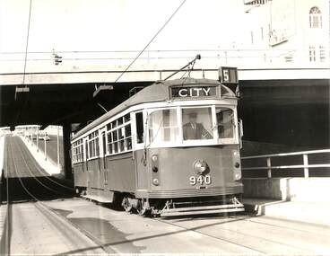 Melbourne Tram Museum
Photograph - Black & White Photograph/s, Melbourne & Metropolitan Tramways Board (MMTB), c July 1970
Black and white photograph - large format - of tram W6 940 inbound on route 5 passing under the St Kilda Junction road over bridge with Queens Way St Kilda reserve track in the background. The tram has the destination of City. The tram was the first to be fitted with marker lights - noted in Bourke St 3/7, Herald Sun 3/7 following strong public pressure. See page 5 of the June 1970 issue of Monarail, the magazine of the Monash University Railway club. See also image i2, from the June 1970 issue of TMSV Running Journal with a photo of the tram at the time of the launch. Image provided by Mal Rowe 30-9-2018.trams, tramways, st kilda junction, w6 class, queens way, tram 940 -
 The Beechworth Burke Museum
Geological specimen - Marble, Unknown
A granular metamorphic rock, marble is derived from limestone or dolomite and composed of calcite or dolomite interlocking grains. Heat and pressure from overlying sediments form it from limestone buried deep in Earth's crust. Graphite, pyrite, quartz, mica, and iron oxides can affect rock texture and colour. This specimen was found in Carrara, Italy. Carrara marble is the most common marble found in Italy, and it gets its name from the region where it is located. The marble was also called Luna marble and was used as a decorative element in buildings and sculptures. It has been quarried since Roman times in the Lunigiana, the northernmost tip of Tuscany, just outside the city of Carrara in the province of Massa and Carrara.Marble is one of the most popular and expensive rocks used in sculpture, architecture, interior decorations, statues, table tops, and novelties. It is available in various colors and textures depending on the chemical composition. The strength of the rock and its ability to hold finer details have made it a favorite among designers. This specimen is part of a larger collection of geological and mineral specimens collected from around Australia (and some parts of the world) and donated to the Burke Museum between 1868-1880. A large percentage of these specimens were collected in Victoria as part of the Geological Survey of Victoria that begun in 1852 (in response to the Gold Rush) to study and map the geology of Victoria. Collecting geological specimens was an important part of mapping and understanding the scientific makeup of the earth. Many of these specimens were sent to research and collecting organisations across Australia, including the Burke Museum, to educate and encourage further study.A solid hand sized Marble (metamorphic rock) predominantly white with specks light grey and ochre geological specimen, geology, geology collection, burke museum, beechworth, marble, carrara marble, italian marble, marble specimen, tuscany -
 Kiewa Valley Historical Society
Postcard Circa 1950, Snow Plough, Bogong High Plain,5,500 Feet Kiewa Hydro-Electric Project, Circa 1950
This postcard was produced in the 1950's for the tourist trade in the Kiewa Valley and Alpine region. It encompasses the period when the State of Victoria was pressured by the ever increasing demand by industry and its population for electricity supplies. Hydro electricity was seen as an untapped natural resource to quench this demand. The Victorian Alps and the rivers flowing into its valleys was ideal for the construction of the Kiewa Hydro Electricity Scheme. The late 1940's saw the development of this scheme and the changing of sections of alpine landscape is covered by this and other postcards/pictures (tourists, construction workers, and established rural populations). This period in time was before the established wildlife and forest/nature groups became political activist who changed legislative acts to protect the environment. This rural region (Kiewa Valley/alpine plains) was at most only significant to a smaller group of winter sports, summer hikers/horse riders and rural farmers/graziers. The numbers of tourists and the increase in the local resident population was boosted by the construction of the Hydro Electricity Scheme. This influx to the regional population resulted in a corresponding diversity in services and brought about an environment that responded to a growing level of tourists and thereby permitting this industry to grow more rapidly than it would have naturally. This postcard details an attraction to the "cleaner" method of providing electricity. This postcard was purchased in 1950 by a surveyor at Landford's Gap. This item is a black and white photograph(professional) of a panoramic view of a snow plough clearing the unsealed road in 1950.This postcard is on quality paper and the reproduction of the picture is of a high standard.For other "tourist" postcards see 0480 (A) -(F) for other photos of similar postcards. kiewa valley tourism, victorian alps, alternate energy supplies, alpine population growth, secv, snow plough -
 Kiewa Valley Historical Society
Postcard Circa 1950, Road to Bogong High Plains Kiewa Hydro Electric Project, Circa 1950's
This postcard was produced in the 1950's for the tourist trade in the Kiewa Valley and Alpine region. It encompasses the period when the State of Victoria was pressured by the ever increasing demand by industry and its population for electricity supplies. Hydro electricity was seen as an untapped natural resource to quench this demand. The Victorian Alps and the rivers flowing into its valleys was ideal for the construction of the Kiewa Hydro Electricity Scheme. The late 1940's saw the development of this scheme and the changing of sections of alpine landscape is covered by this and other postcards/pictures (tourists, construction workers, and established rural populations). This period in time was before the established wildlife and forest/nature groups became political activist who changed legislative acts to protect the environment.This rural region (Kiewa Valley/alpine plains) was at most only significant to a smaller group of winter sports, summer hikers/horse riders and rural farmers/graziers. The numbers of tourists and the increase in the local resident population was boosted by the construction of the Hydro Electricity Scheme. This influx to the regional population resulted in a corresponding diversity in services and brought about an environment that responded to a growing level of tourists and thereby permitting this industry to grow more rapidly than it would have naturally. This postcard details an attraction to the "cleaner" method of providing electricity. This postcard was purchased in 1950 by a surveyor at Landford's Gap.This black and white photograph on a Valentine's postcard is from a V2 Argus photograph.. It is on a 200g/m paper density photo side gloss. See 0480 (A) - (G) for other photos of similar postcards.In white lettering " ROAD TO BOGONG HIGH PLAINS KIEWA HYDRO-ELECTRIC PROJECT", V3secv, road making, victorian alps -
 Kiewa Valley Historical Society
Postcard - Rocky Valley - Circa 1950, 1950
This postcard was produced in the 1950's for the tourist trade in the Kiewa Valley and Alpine region. It encompasses the period when the State of Victoria was pressured by the ever increasing demand by industry and its population for electricity supplies. Hydro electricity was seen as an untapped natural resource to quench this demand. The Victorian Alps and the rivers flowing into its valleys was ideal for the construction of the Kiewa Hydro Electricity Scheme. The late 1940's saw the development of this scheme and the changing of sections of alpine landscape is covered by this and other postcards/pictures (tourists, construction workers, and established rural populations). This period in time was before the established wildlife and forest/nature groups became political activist who changed legislative acts to protect the environment.This rural region (Kiewa Valley/alpine plains) was at most only significant to a smaller group of winter sports, summer hikers/horse riders and rural farmers/graziers. The numbers of tourists and the increase in the local resident population was boosted by the construction of the Hydro Electricity Scheme. This influx to the regional population resulted in a corresponding diversity in services and brought about an environment that responded to a growing level of tourists and thereby permitting this industry to grow more rapidly than it would have naturally. This postcard details an attraction to the "cleaner" method of providing electricity. This postcard was purchased in 1950 by a surveyor at Landford's Gap.This black and white photograph is from a Valentine's V2 Argus postcard. It is on a 200g/m paper density one side gloss. See also KVHS 0480 (A) to (L) for similar postcards. "ROCKY VALLEY FROM BOGONG HIGH PLAINS KIEWA HYDRO-ELECTRIC PROJECT" "V1"kiewa valley tourism, victorian alps, alternate energy supplies, alpine population growth, rocky valley, secv -
 Kiewa Valley Historical Society
Postcard - Junction Dam - Circa 1950, Circa 1950's
This postcard was produced in the 1950's for the tourist trade in the Kiewa Valley and Alpine region. It encompasses the period when the State of Victoria was pressured by the ever increasing demand by industry and its population for electricity supplies. Hydro electricity was seen as an untapped natural resource to quench this demand. The Victorian Alps and the rivers flowing into its valleys was ideal for the construction of the Kiewa Hydro Electricity Scheme. The late 1940's saw the development of this scheme and the changing of sections of alpine landscape is covered by this and other postcards/pictures (tourists, construction workers, and established rural populations). This period in time was before the established wildlife and forest/nature groups became political activist who changed legislative acts to protect the environment.This rural region (Kiewa Valley/alpine plains) was at most only significant to a smaller group of winter sports, summer hikers/horse riders and rural farmers/graziers. The numbers of tourists and the increase in the local resident population was boosted by the construction of the Hydro Electricity Scheme. This influx to the regional population resulted in a corresponding diversity in services and brought about an environment that responded to a growing level of tourists and thereby permitting this industry to grow more rapidly than it would have naturally. This postcard details an attraction to the "cleaner" method of providing electricity. This postcard was purchased in 1950 by a surveyor at Landford's Gap.This black and white photograph is a Valentine's postcard, from a V2 Argus photograph. It is on a 200g/m paper density with only the photo side gloss.Front "JUNCTION DAM & SPILLWAY, BOGONG KIEWA HYDRO-ELECTRIC PROJECT" on the flip side "VALENTINE'S POST CARD " "A GENUINE PHOTOGRAPH"kiewa valley tourism, victorian alps, alternate energy supplies, alpine population growth, junction dam, secv -
 Kiewa Valley Historical Society
Postcard - Junction Dam - Circa 1950, Circa 1950
This postcard was produced in the 1950's for the tourist trade in the Kiewa Valley and Alpine region. It encompasses the period when the State of Victoria was pressured by the ever increasing demand by industry and its population for electricity supplies. Hydro electricity was seen as an untapped natural resource to quench this demand. The Victorian Alps and the rivers flowing into its valleys was ideal for the construction of the Kiewa Hydro Electricity Scheme. The late 1940's saw the development of this scheme and the changing of sections of alpine landscape is covered by this and other postcards/pictures (tourists, construction workers, and established rural populations). This period in time was before the established wildlife and forest/nature groups became political activist who changed legislative acts to protect the environment.This rural region (Kiewa Valley/alpine plains) was at most only significant to a smaller group of winter sports, summer hikers/horse riders and rural farmers/graziers. The numbers of tourists and the increase in the local resident population was boosted by the construction of the Hydro Electricity Scheme. This influx to the regional population resulted in a corresponding diversity in services and brought about an environment that responded to a growing level of tourists and thereby permitting this industry to grow more rapidly than it would have naturally. This postcard details an attraction to the "cleaner" method of providing electricity. This postcard was purchased in 1950 by a surveyor at Landford's Gap.This black and white photograph on a Valentine's postcard is from a V2 Argus photograph. It is on a 200g/m paper density one side gloss only/. See 0480 (A) -(L) for other photos of similar postcards."JUNCTION DAM & SPILLWAY, LAKE GUY, BOGONG, KIEWA HYDRO-ELECTRIC PROJECT" "V5" on the flip side" VALENTINE'S POST CARD " "A GENUINE PHOTOGRAPH"kiewa valley tourism, victorian alps, alternate energy supplies, alpine population growth, junction dam, secv -
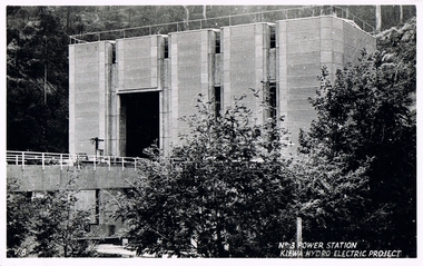 Kiewa Valley Historical Society
Postcard Circa 1950, No.3 Power Station Kiewa Hydro-electric Project "V.8", Circa 1950
This postcard was produced in the 1950's for the tourist trade in the Kiewa Valley and Alpine region. It encompasses the period when the State of Victoria was pressured by the ever increasing demand by industry and its population for electricity supplies. Hydro electricity was seen as an untapped natural resource to quench this demand. The Victorian Alps and the rivers flowing into its valleys was ideal for the construction of the Kiewa Hydro Electricity Scheme. The late 1940's saw the development of this scheme and the changing of sections of alpine landscape is covered by this and other postcards/pictures (tourists, construction workers, and established rural populations). This period in time was before the established wildlife and forest/nature groups became political activist who changed legislative acts to protect the environment.This rural region (Kiewa Valley/alpine plains) was at most only significant to a smaller group of winter sports, summer hikers/horse riders and rural farmers/graziers. The numbers of tourists and the increase in the local resident population was boosted by the construction of the Hydro Electricity Scheme. This influx to the regional population resulted in a corresponding diversity in services and brought about an environment that responded to a growing level of tourists and thereby permitting this industry to grow more rapidly than it would have naturally. This postcard details an attraction to the "cleaner" method of providing electricity. This postcard was purchased in 1950 by a surveyor at Landford's Gap.This black and white photograph from a Valentine's postcard is from a V2 Argus photograph postcard. It is on a 200g/m paper density photo side gloss. See 0480 (A) - (K) for other photos of similar postcards."No.3 POWER STATION KIEWA HYDRO ELECTRIC PROJECT" "V8"kiewa valley tourism, victorian alps, alternate energy supplies, alpine population growth, secv -
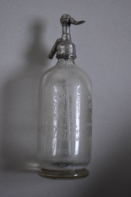 Warrnambool and District Historical Society Inc.
Soda Syphon, Fletcher, c 1930 (contents of syphon)
This soda syphon is a device for dispensing carbonated or soda water. The valve allows portion of the contents to be dispensed whilst maintaining the pressure inside to keep the rest of the contents from going flat. The bottle is marked ‘J. Fletcher’. John Fletcher worked as a boy at Rowley’s cordial factory in Banyan Street, Warrnambool. He then worked for John Davis who had established the Union Cordial Factory in Koroit Street, Warrnambool in the 1860s. In 1885 John Fletcher bought the Davis business and operated it until 1930. John Fletcher sold the business to Ralph Reeves and as Reeves initially used Fletcher bottles and syphons, the contents of the bottle could have come from the time of either John Fletcher or Ralph Reeves. This syphon is of interest as it comes from a mid 20th century cordial factory in Warrnambool. Cordial manufacturing was an important industry in Warrnambool for over 100 years. This is a clear glass soda syphon with a round sold base and a rounded body and a metal pump and valve mechanism affixed to the top opening. A glass tube is inside the bottle and is part of the pump mechanism. The top metal section is very corroded. The side of the bottle has the Fletcher trademark - the stylized letters J and F. ‘J. Fletcher Trade Mark Warrnambool’ ‘J. Fletcher’ ‘British Syphon Mfg Co. Ltd London’ cordial manufacturing in warrnambool, fletcher, history of warrnambool -
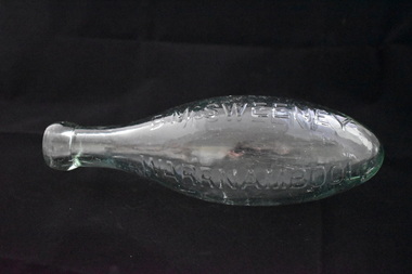 Warrnambool and District Historical Society Inc.
Bottle, D Mc Sweeney, Late 19th century
This torpedo glass bottle comes from the Warrnambool aerated waters business of Daniel McSweeney. It would have held a type of soda and the bottle was made so that it could not stand up and so the soda was kept in contact with the cork. This stopped the cork from shrinking and so the pressure was not lost. Daniel McSweeney opened a cordial factory in Fairy Street in 1885 and, by the early 1890s had transferred his business to Henna Street. This factory was advertised as the largest cordial factory in the Western District, though this appeared to refer to the size of the building. In the late 1890s James Trigg leased the factory from McSweeney for some time. The factory was closed in 1900 but the building remains today and is occupied by the Alderdice Brass FoundryThis bottle is of interest as one of few bottles we have that came from the Warrnambool cordial factory of Daniel McSweeney. He was a prominent maker of soft drinks in the late 19th century.This is a green glass bottle. It is a ‘torpedo’ bottle so it is of a spherical shape with a pointed curved end, a rounded neck and a round moulded top. There is no stopper. The name of the manufacturer of the soft drink contents is embedded into the glass on one side. ‘D.McSweeney Warrnambool’ daniel mcsweeney warrnambool, cordial manufacturers in warrnambool, history of warrnambool -
Federation University Historical Collection
Document - Document - Letter, Ballarat Junior Technical School: Letters relating to equipment to establish a practice weather-observation station. 1952
.1: Letter from H B Selby & Co Pty Ltd re the order for a Fortin Barameter. Asking for arrangement for Staff member to collect as it is very fragile. The glassware for the Regnault Vapour pressure Apparatus not previously sent has been forwarded. .2: Letter from the school to The Director Weather Bureau Melbourne. Outlines establishing a weather-observing station as part of general science. Mr McLachlin in Ballarat will guide the school as to method, procedure, records, etc List of equipment on loan - Stevenson Screen, maximum and minimum thermometers, wet and dry bulb thermometers, 8" rain gauge, cloud chart, instructions for reductions of barometer readings, weather code for transmission, record book. 2 Cream pages, typed .1: Letterhead for H B Selby & Co Pty Ltd - Black and red inks Signature of V T Parkinson, Managerballarat junior technical school, head master, l garner, h b selby, weather bureau, weather station, observations, fortin barameter, regnault vapour pressure apparatus, stevenson screen, maximum thermometer, minimum thermometer, bulb thermometers, rain gauge, instructions, weather code, record book -
 Kiewa Valley Historical Society
Postcard Circa 1950, Lake Guy Dam and Bogong Village, Circa 1950
This postcard was produced in the 1950's for the tourist trade in the Kiewa Valley and Alpine region. It encompasses the period when the State of Victoria was pressured by the ever increasing demand by industry and its population for electricity supplies. Hydro electricity was seen as an untapped natural resource to quench this demand. The Victorian Alps and the rivers flowing into its valleys was ideal for the construction of the Kiewa Hydro Electricity Scheme. The late 1940's saw the development of this scheme and the changing of sections of alpine landscape is covered by this and other postcards/pictures (tourists, construction workers, and established rural populations). This period in time was before the established wildlife and forest/nature groups became political activist who changed legislative acts to protect the environment.This rural region (Kiewa Valley/alpine plains) was at most only significant to a smaller group of winter sports, summer hikers/horse riders and rural farmers/graziers. The numbers of tourists and the increase in the local resident population was boosted by the construction of the Hydro Electricity Scheme. This influx to the regional population resulted in a corresponding diversity in services and brought about an environment that responded to a growing level of tourists and thereby permitting this industry to grow more rapidly than it would have naturally. This postcard details an attraction to the "cleaner" method of providing electricity. This postcard was purchased in 1950 by a surveyor at Landford's Gap.This black and white photograph from a Valentine's postcard is from a V2 Argus photograph postcard. It is on a 200g/m paper density photo side gloss. See 0480 (B) - (F) for other photos of similar postcards.In white lettering " LAKE GUY & BOGONG VILLAGE KIEWA HYDRO-ELECTRIC PROJECT"kiewa valley tourism, victorian alps, alternate energy supplies, alpine population growth -
 Kiewa Valley Historical Society
Postcard Circa 1950, Snowfall at Bogong Village Kiewa Hydro-Electric Project, 1950s
This postcard was produced in the 1950's for the tourist trade in the Kiewa Valley and Alpine region. It encompasses the period when the State of Victoria was pressured by the ever increasing demand by industry and its population for electricity supplies. Hydro electricity was seen as an untapped natural resource to quench this demand. The Victorian Alps and the rivers flowing into its valleys was ideal for the construction of the Kiewa Hydro Electricity Scheme. The late 1940's saw the development of this scheme and the changing of sections of alpine landscape is covered by this and other postcards/pictures (tourists, construction workers, and established rural populations). This period in time was before the established wildlife and forest/nature groups became political activist who changed legislative acts to protect the environment.This rural region (Kiewa Valley/alpine plains) was at most only significant to a smaller group of winter sports, summer hikers/horse riders and rural farmers/graziers. The numbers of tourists and the increase in the local resident population was boosted by the construction of the Hydro Electricity Scheme. This influx to the regional population resulted in a corresponding diversity in services and brought about an environment that responded to a growing level of tourists and thereby permitting this industry to grow more rapidly than it would have naturally. This postcard details an attraction to the "cleaner" method of providing electricity. This postcard was purchased in 1950 by a surveyor at Landford's Gap.This scanned black and white photograph of a postcard, shows vehicles covered in thick snow at Bogong Village in 1950. See 0480(A), (C) - (F) for other similar photos of postcards available at this period."SNOWFALL AT BOGONG VILLAGE KIEWA HYDRO-ELECTRICITY PROJECT"kiewa valley tourism, victorian alps, alternate energy supplies, alpine population growth, bogong village, secv -
 Kiewa Valley Historical Society
Postcard Circa 1950, Scene in Bogong Village Kiewa Hydro-Electric Project, 1950s
This postcard was produced in the 1950's for the tourist trade in the Kiewa Valley and Alpine region. It encompasses the period when the State of Victoria was pressured by the ever increasing demand by industry and its population for electricity supplies. Hydro electricity was seen as an untapped natural resource to quench this demand. The Victorian Alps and the rivers flowing into its valleys was ideal for the construction of the Kiewa Hydro Electricity Scheme. The late 1940's saw the development of this scheme and the changing of sections of alpine landscape is covered by this and other postcards/pictures (tourists, construction workers, and established rural populations). This period in time was before the established wildlife and forest/nature groups became political activist who changed legislative acts to protect the environment. This rural region (Kiewa Valley/alpine plains) was at most only significant to a smaller group of winter sports, summer hikers/horse riders and rural farmers/graziers. The numbers of tourists and the increase in the local resident population was boosted by the construction of the Hydro Electricity Scheme. This influx to the regional population resulted in a corresponding diversity in services and brought about an environment that responded to a growing level of tourists and thereby permitting this industry to grow more rapidly than it would have naturally. This postcard details an attraction to the "cleaner" method of providing electricity. This postcard was purchased in 1950 by a surveyor at Landford's Gap. The couple shown in this photograph would have been employed by the S.E.C. under the Kiewa Hydro-Electricity Scheme.This item is a scanned black and white photograph of a couple walking along a gravel street in Bogong Village in 1950. See 0480 (A) ,(B), (D) - (F) for other photos of similar postcards" SCENE IN BOGONG VILLAGE KIEWA HYDRO-ELECTRIC PROJECT"kiewa valley tourism, victorian alps, alternate energy supplies, alpine population growth, bogong, secv -
 Kiewa Valley Historical Society
Postcard Circa 1950, Howman Gap Hostel under snow Kiewa Hydro-Electric Project, Circa 1950
This postcard was produced in the 1950's for the tourist trade in the Kiewa Valley and Alpine region. It encompasses the period when the State of Victoria was pressured by the ever increasing demand by industry and its population for electricity supplies. Hydro electricity was seen as an untapped natural resource to quench this demand. The Victorian Alps and the rivers flowing into its valleys was ideal for the construction of the Kiewa Hydro Electricity Scheme. The late 1940's saw the development of this scheme and the changing of sections of alpine landscape is covered by this and other postcards/pictures (tourists, construction workers, and established rural populations). This period in time was before the established wildlife and forest/nature groups became political activist who changed legislative acts to protect the environment.This rural region (Kiewa Valley/alpine plains) was at most only significant to a smaller group of winter sports, summer hikers/horse riders and rural farmers/graziers. The numbers of tourists and the increase in the local resident population was boosted by the construction of the Hydro Electricity Scheme. This influx to the regional population resulted in a corresponding diversity in services and brought about an environment that responded to a growing level of tourists and thereby permitting this industry to grow more rapidly than it would have naturally. This postcard details an attraction to the "cleaner" method of providing electricity. This postcard was purchased in 1950 by a surveyor at Landford's Gap.This item is a scanned black and white photograph of a panoramic view of Howman Gap Hostel under snow in 1950 (a closed village, entry by pass only). This accommodation was for construction workers only. See 0480 (A) -(E) for other photos of similar postcards.On the photo, " Howman Gap Hostel under snow Kiewa Hydro-Electric Project" . On postcard address and personal information side "V.2 Valentine's Post Card "kiewa valley tourism, victorian alps, alternate energy supplies, alpine population growth, bogong, secv, howman's gap hostel -
 Ballarat Tramway Museum
Photograph - Colour Photograph/s - set of 8, Lloyd Rogers, Mar. 1984
Yields information about the operation by the Begonia Festival and in particular when 661 was repainted.Set of 8 colour prints of BTPS trams during the 1984 Begonia Festival, just after the repainting of 661 has been completed. Each print has two small copies of the main photo on the right hand side. Printed on Sakuracolor paper. .1 - 661, 27 and 38 at the depot .2 - 661 at St Aidans drive with the parking fee collectors in the view. Interior cab view showing controller, brake handle and pressure gauge. .3 - crossing 14 at the loop. .4 - 661 and 27 at the depot .5 - interior view of No. 14 .6 - interior view of depot with 28 and 26 being rebuilt in the view. .7. - interior view of 661 .8 - interior view of 661 with the tram being swept out. trams, tramways, begonia festival, btm, depot, wendouree parade, tram 661, tram 27, tram 38, tram 14, tram 28, tram 26 -
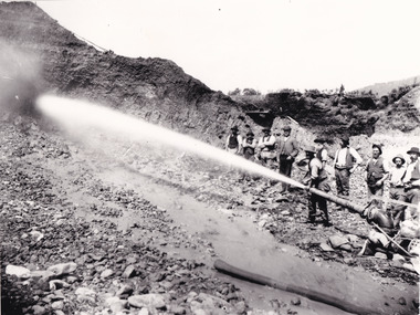 The Beechworth Burke Museum
Photograph - Photograph - Reproduction, Unknown c1852-1940
Depicted in the photograph are ten miners standing at a cliff face using a high pressure hose, in Beechworth, Victoria. The miners are located in the Three Mile Creek division, in the Beechworth Mining District established January 4th 1858 under An Act for Amending the Laws Relating to the Goldfields by the Governor-in-Council. The Ovens Gold Rush began at Beechworth in February 1852 and was followed by Yackandandah and the 'Indigo Goldfield'. The strategies applied to mining in Beechworth were distinct in comparison to other goldfields in Victoria such as Bendigo and Ballarat. The miners in Beechworth utlised 'hydraulic sluicing' to remove washdirt, the long water races and deep tailraces constructed through solid rock with an estimated 900 miles of water races cut through the Beechworth fields by 1880, demonstrating great engineering feats. The photograph taken is significant as it is a visual representation of the mining strategy, 'hydraulic sluicing' that was particularly unique to the Beechworth mines, particularly in Victoria and an engineering feat.Black and white rectangular photograph printed on matte photographic paper, unmounted print.beechworth mining district, mining, three mile creek division, three mile creek -
 The Beechworth Burke Museum
Photograph
This image shows an unknown location in the area of Beechworth that was possibly used as a sluicing mining site for gold during the Victorian Gold Rush. This era saw an influx of Chinese immigrants and Australian prospectors hoping to strike it rich on the fields. Many companies such as the Rocky Mountain Extended Gold Sluicing Company Ltd and the Cocks Pioneer Gold &Tin Sluicing Company also set up mines in the area. This site may be the location of one of these company's mines. The wooden logs are reminiscent of known sluicing operations in the era from that time. Sluicing involved the use of high-pressured hoses to clear away soil from earth that had been dug up by miners and was a popular method of excavation in the area, although it had severe impacts on the environment.The search for gold is ingrained into the history of Victoria and therefore, images like this one which portray an open cut sluicing site can reveal important information for society and technology for the date when the photograph was taken. This image is of important historical significance for its ability to convey information about sluicing and the methods used to find gold. It also shows a location where sluicing was undertook which provides insight into the impact of sluicing on the environment at a time when it was done.A colour rectangular photograph printed on glossy photographic paperReverse: 6855 /beechworth, gold rush, sluicing, mining