Showing 323 items matching "single storey"
-
 Glenelg Shire Council Cultural Collection
Photograph - Photograph - Percy Street, Portland, 1970s
Photographic print of a rephotographed photograph. Image shows west side of Percy Street between Henty and Tyers Streets. Four single story buildings (one behind wooden fence) facing street. Robertson Store - 2 storey, round roof, far right of photo. Several people and horses and carts in street (unmade).Front: 'Robertson Store' - green inkportland street scene, percy street -
Glenelg Shire Council Cultural Collection
Photograph - Sheet of 12 contact prints - Various historic Portland buildings and Landmarks, c. 1970
Sheet of 12 contact prints of rephotographed photographs. Identifying numbers 5720 a, b, c, d, e, f, g, h, i, j, k, l (a) Observatory Hill (b) Builders Arms Hotel (c) First jetty and immigration depot (d) Pile driver-1st pile Ocean Pier (e) Residence of William Corney (f) Row of single wooden houses on beach, Observatory Hill in background (g) Double storey stone building (h) Mrs Edward Henty (i) View of spit from Henty Beach (j) Julia Street (k) Same as (c) - First jetty and immigration depot (l) Dray loaded with bales outside Grant & Co merchants -
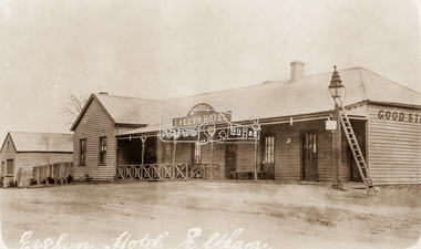 Eltham District Historical Society Inc
Photograph, Evelyn Hotel, Eltham, c.1911
Postcard image of W. Morris Evelyn Hotel, cnr. Main Road and Pitt Street, Eltham, opposite present hotel. This image is post the 1910 fire which damaged the southern two-storey section. It was rebuilt as single story. The hotel was delicensed in 1919 and became a Dining Room then a boarding house. It was destroyed by fire in the summer of 1931 when at the time it was occupied solely by the McLean family, Hector and Louisa McLean who had five young daughters at the time.Postcard photoRetun to Garnet Burges c/o Judge Bookhotels, evelyn hotel, eltham, main road, pitt street, fountain hotel, william morris -
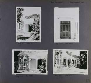 Glen Eira Historical Society
Album - Album page, Rose Craddock, Rose Craddock Avenue, Circa 1972
... /places/35279 (as of 17/02/2021) A single storeyed stuccoed villa ...This photograph is part of the Caulfield Historical Album 1972. This album was created in approximately 1972 as part of a project by the Caulfield Historical Society to assist in identifying buildings worthy of preservation. The album is related to a Survey the Caulfield Historical Society developed in collaboration with the National Trust of Australia (Victoria) and Caulfield City Council to identify historic buildings within the City of Caulfield that warranted the protection of a National Trust Classification. Principal photographer thought to be Trevor Hart, member of Caulfield Historical Society. Most photographs were taken between 1966-1972 with a small number of photographs being older and from unknown sources. All photographs are black and white except where stated, with 386 photographs over 198 pages. From Victorian Heritage Database citation for H0589 Rosecraddock 4-10 Craddock Avenue and 2-8 Keverell CAULFIELD NORTH https://vhd.heritagecouncil.vic.gov.au/places/35279 as at (30/10/2020) "Rosecraddock" is regionally important as a surviving large villa from the early Victorian (1850's) period, offering insight into the lifestyles of the privileged in Caulfield at that time. Its importance is enhanced through its long association with the Langdon family and, in particular, Henry Joseph Langdon, founder of H.J. Langdon and Company, China merchants. Victorian Heritage Database HO16 Rosecraddock, 2-8 Keverell Road & 4-10 Craddock Avenue Caulfield North https://vhd.heritagecouncil.vic.gov.au/places/35279 (as of 17/02/2021) A single storeyed stuccoed villa with west facing facade consisting of a parapeted and recessed central section with hipped slate roof and timber posted verandah with cast iron lace. Projecting pavilions have bayed windows and a secondary wing runs north with angled corners and prominent chimney stack. The front entrance is situated at the north end of the central section and is given emphasis by a small hip roof and false pediment to the verandah. Outbuildings include the timber stables with characteristic hay loft gablet and fretted barges to the south-east. Rear additions in brick and timber are of an early date and utilitarian in character. Also see https://vhd.heritagecouncil.vic.gov.au/places/277 for Significance Statement for the H0589 Victorian Heritage Register listing.Page 174 of Photograph Album with four photographs of Rose Craddock.Handwritten: "Rose Craddock" Rose Craddock Ave. top right] / Neg 197 Nov 1972 [under top left photo] / Neg 209 Nov 1972 [under top right photo] / Neg 196 Nov 1972 [under bottom left photo] / Neg 195 198 Nov 1972 [under bottom right photo] / 174 [bottom right]trevor hart, chimneys, porch, rose craddock, rosecraddock, ringwood, 1850's, henry joseph langdon, h.j. langdon, h.j. langdon and company, china merchants, rosecraddock place, slate roof, return verandah, decorative brackets, keverell road, caulfield north, early victorian style, protruding bay windows, cast iron work, rendered walls, entrances, mansions, craddock avenue -
 Glen Eira Historical Society
Album - Album page, Glenferrie Street, 4, Circa 1972
... -1929) as his own house and constructed in 1906. A single storey ...This photograph is part of the Caulfield Historical Album 1972. This album was created in approximately 1972 as part of a project by the Caulfield Historical Society to assist in identifying buildings worthy of preservation. The album is related to a Survey the Caulfield Historical Society developed in collaboration with the National Trust of Australia (Victoria) and Caulfield City Council to identify historic buildings within the City of Caulfield that warranted the protection of a National Trust Classification. Principal photographer thought to be Trevor Hart, member of Caulfield Historical Society. Most photographs were taken between 1966-1972 with a small number of photographs being older and from unknown sources. All photographs are black and white except where stated, with 386 photographs over 198 pages. From Glen Eira Heritage Management Plan 1996 by Andrew Ward: In 1905, most of portion 27 was vacant land, however Glenferrie Street had been formed and the land subsequently subdivided. In 1906, Robert Joseph Haddon, architect and painter, designed and built for his private residence, a brick house on the west side. Haddon named the house "Anselm". Also built on the property were a garage and fibro cement studio. "Anselm" is architecturally important at the State level as a substantially intact, highly personalised and boldly expressed house expressive the Arts and Crafts movement and incorporating Art Nouveaux enrichment in a variety of forms, the use of ornamental terra cotta tiles to the comer tower being of special note. Its importance at the State level is strengthened by its place as the home of the noted architect and Melbourne's most influential exponent (Freeland, J.M., Architecture in Australia, p. 213) of the Art Nouveaux movement.https://vhd.heritagecouncil.vic.gov.au/places/4442 Victorian Heritage Register: What is significant? Anselm was designed by noted English born architect Robert Joseph Haddon(1866-1929) as his own house and constructed in 1906. A single storey Arts and Crafts influenced red brick house with attic, Anselm has a pyramidal slate roof with prominent chimney stacks. There is a octagonal corner tower with saucer shaped domed roof surmounted by a weather vane, and the tower has decorative terracotta panels immediately below the eaves line. The front door opens immediately into a large living or common room, screened from view by a timber and bottle glass screen. The large room was designed to function as a drawing and dining room. The house is rich with hand crafted details including door and window furniture, wrought iron gutter brackets, fireplaces (one with built in wood box), and fire tools. The interior decoration includes hand painted frieze of Port Phillip in the study, and a hand painted frieze of turbulent sea with sailing boats in the tiled bathroom. There is a small hand painted tile at the base of the tower which states ?This building was erected AD1906 from designs by Robt J Haddon FRIBA,Lond FRIVA Melb Architect?. He also designed an attic addition which was constructed in 1927. Anselm is substantially intact although the double casement window immediately to the south of the front door was originally circular....Page 60 of Photograph Album with three exterior photographs (one portrait and two landscape) of Anselm.Hand written: 4 Glenferrie Street [top right] / ANSELM 4 Glenferrie St [under top photo] / 60 [bottom right] trevor hart, anselm, art nouveaux, arts and crafts, tower, bay window, glenferrie street, robert joseph haddon, 1900's, terra cotta tiles, double storey, caulfield north, corner tower, gates, cast iron work -
 Glen Eira Historical Society
Album - Album page, Glenferrie Street, 4, Circa 1972
... ) as his own house and constructed in 1906. A single storey Arts ...This photograph is part of the Caulfield Historical Album 1972. This album was created in approximately 1972 as part of a project by the Caulfield Historical Society to assist in identifying buildings worthy of preservation. The album is related to a Survey the Caulfield Historical Society developed in collaboration with the National Trust of Australia (Victoria) and Caulfield City Council to identify historic buildings within the City of Caulfield that warranted the protection of a National Trust Classification. Principal photographer thought to be Trevor Hart, member of Caulfield Historical Society. Most photographs were taken between 1966-1972 with a small number of photographs being older and from unknown sources. All photographs are black and white except where stated, with 386 photographs over 198 pages. From Glen Eira Heritage Management Plan 1996 by Andrew Ward: In 1905, most of portion 27 was vacant land, however Glenferrie Street had been formed and the land subsequently subdivided. In 1906, Robert Joseph Haddon, architect and painter, designed and built for his private residence, a brick house on the west side. Haddon named the house "Anselm". Also built on the property were a garage and fibro cement studio. "Anselm" is architecturally important at the State level as a substantially intact, highly personalised and boldly expressed house expressive the Arts and Crafts movement and incorporating Art Nouveaux enrichment in a variety of forms, the use of ornamental terra cotta tiles to the comer tower being of special note. Its importance at the State level is strengthened by its place as the home of the noted architect and Melboume's most influential exponent (Freeland, J.M., Architecture in Australia, p. 213) of the Art Nouveaux movement. Victorian Heritage Register https://vhd.heritagecouncil.vic.gov.au/places/4442 What is significant? Anselm was designed by noted English born architect Robert Joseph Haddon(1866-1929) as his own house and constructed in 1906. A single storey Arts and Crafts influenced red brick house with attic, Anselm has a pyramidal slate roof with prominent chimney stacks. There is a octagonal corner tower with saucer shaped domed roof surmounted by a weather vane, and the tower has decorative terracotta panels immediately below the eaves line. The front door opens immediately into a large living or common room, screened from view by a timber and bottle glass screen. The large room was designed to function as a drawing and dining room. The house is rich with hand crafted details including door and window furniture, wrought iron gutter brackets, fireplaces (one with built in wood box), and fire tools. The interior decoration includes hand painted frieze of Port Phillip in the study, and a hand painted frieze of turbulent sea with sailing boats in the tiled bathroom. There is a small hand painted tile at the base of the tower which states ?This building was erected AD1906 from designs by Robt J Haddon FRIBA,Lond FRIVA Melb Architect?. He also designed an attic addition which was constructed in 1927. Anselm is substantially intact although the double casement window immediately to the south of the front door was originally circular....Page 61 of Photograph Album with one exterior photograph (portrait) of Anselm.Hand written: 61 [bottom left] trevor hart, anselm, art nouveaux, arts and crafts, tower, bay window, glenferrie street, robert joseph haddon, 1900's, terra cotta tiles, double storey, caulfield north, corner tower, brick house, attics -
 Glen Eira Historical Society
Album - Album page, Booran Road, 30, Circa 1972
... consists of a single storey brick Italianate villa, jockeys ...This photograph is part of the Caulfield Historical Album 1972. This album was created in approximately 1972 as part of a project by the Caulfield Historical Society to assist in identifying buildings worthy of preservation. The album is related to a Survey the Caulfield Historical Society developed in collaboration with the National Trust of Australia (Victoria) and Caulfield City Council to identify historic buildings within the City of Caulfield that warranted the protection of a National Trust Classification. Principal photographer thought to be Trevor Hart, member of Caulfield Historical Society. Most photographs were taken between 1966-1972 with a small number of photographs being older and from unknown sources. All photographs are black and white except where stated, with 386 photographs over 198 pages. From Glen Eira Heritage Management Plan 1996 by Andrew Ward: In 1888, John Leek, a trainer, owned Lot 15, measuring one and three quarter acres, in Booran Road, north side between Glen Eira and Neerim Roads. The land backed onto the Caulfield Racecourse Reserve. NAV was £45. In 1890 Leek built for his residence, a ten roomed brick house on the site. NAV was £200. Leek was the owner/trainer of "Ingliston" who won the Caulfield Cup in 1900. Upon the horse's death in 1901, Leek is understood to have defied tradition by spending £20 on boots for the "ragged urchins in Bourke Street" instead of "shouting" at the bar. By 1899, the property was owned and occupied by Alfred Merrill, a dentist and was known as "Andover". NA V had decreased to £ll0. By 1910, Leslie Macdonald, a gentleman had purchased the property and renamed it "Moidart". In 1910-11 Macdonald sold it to John Robertson. The property had extensive wood stables on its north-east boundary and several other outbuildings. The house continued to be described as "Brick, ten rooms" as it was in 1926 when it was owned and occupied by John Arthur, a managing director. The land measured la.2r.31p. and had a NAV of £235. Nine people lived there. In 1926, Arthur also owned the adjoining Lot 16. Other racehorses of note, known to have been stabled here include Sobar, Havelock, Proud, Future and Lord.Victorian Heritage Register https://vhd.heritagecouncil.vic.gov.au/places/13532 What is significant? Lord Lodge is a thoroughbred racehorse training complex adjacent to Caulfield Racecourse, established in 1890. The area immediately around the racecourse has been associated with horse racing activities and businesses servicing the industry since the development of the racecourse in late the 19th century. Lord Lodge was named by the present occupants after the champion racehorse Lord who was stabled there in the 1950s. In the early 20th century the property was known as 'Andover' and subsequently 'Moidart'. The site consists of a single storey brick Italianate villa, jockeys' quarters, stables and open day yards with direct access to Caulfield racecourse from the rear of the property. The villa of 10 rooms on bluestone foundations was constructed in 1890 by John Leek, a horse trainer who purchased the newly subdivided land in 1888. The house has many Victorian Italianate or Boom Style features although it is more modest than many villas of its style. It has an asymmetrical facade with a faceted bay window and a prominent central tower with low pitch pyramidal roof that provides a clear view of the racecourse. Other characteristic features include stilted segmented arches, bracketed eaves, stucco wall finish and cast cement ornamentation. A room has been added on the north-facing verandah in sympathetic style and finish. Internally the rooms are substantially intact with original marble fireplaces and intricate ceiling roses and cornices. An entrance toward the rear of the southern side of the house is said to be where the stable hands, jockeys and other staff lined up for their meals. In the southeast corner of the property, backing directly on to Caulfield racecourse, is a substantial late Victorian timber stable, probably constructed in the 1890s but first appearing on the property title in 1910. The stable has 12 stalls, a loft and brick pavement and jerkin head roof form with varnished pine-lined ceiling carried on a chamfered timber frame. It has an original roof lantern. The doors of the stalls are not the original sliding doors but swing doors obtained from a barn at Epsom Racecourse in Mordialloc prior to demolition. Outside the gambrel roof has fretted barges but the building is otherwise utilitarian. Timber throughout the stalls has been worn by chewing and rubbing of horses over the century of its use. In the southern half of the property are open day yards where the racehorses are kept during the day. The red brick, single storey jockeys' quarters to the rear of the villa were probably built around 1950. A small brick, possibly late Victorian structure on the eastern boundary thought to have originally been a gardening shed, has been converted to a stable of two stalls. Modern concrete brick stables fill the northeast portion of the property. At the front of the property two Moreton Bay Figs (Ficus macrophylla), probably planted in the late 19th century, provide shade for horses in the day yards. In the 1890s John Leek sold the property, relocating his training facility to one of the newly established racecourses at Mentone or Mordialloc (Epsom). By 1899, the property was owned and occupied by Alfred Merrill, a dentist, who named the property 'Andover'. In 1910 it was purchased by Leslie McDonald, a gentleman, and renamed 'Moidart'; sold in 1910-1911 to John Robertson; and again in 1926 to John Arthur, a racehorse owner. The Victorian Amateur Turf Club purchased the property in the late 1930s and since this time has been leased to racehorse trainers. It is unclear whether the property operated as a training facility between 1899 - 1926. Several notable trainers and jockeys are associated with Lord Lodge. The best known is Arthur 'Scobie' Breasley, Australia's most successful jockey who was apprenticed to trainer Pat Quinlan at Lord Lodge (then 'Moidart') from 1928 - 1935. Breasley rode winners of the Caulfield Cup in four successive years 1942-45 and again in 1952. John Leek, the original owner of Lord Lodge trained Ingliston, the 1900 Caulfield Cup winner. Along with 'Lord' a number of well known racehorses including Sobar, Havelock, Proud and Future were trained at Lord Lodge .....Page 40 of Photograph Album with three landscape photographs of the exterior of this house.Handwritten: 30 Booran Road [top right hand corner] / 40 [bottom right]trevor hart, jenny o'donnell, booran road, mansion, caulfield east, ingliston, sobar, havelock, proud, future, lord, andover, moidart, lord lodge, grace darling, caulfield racecourse reserve, victorian amateur turf club, historic buildings register, national estate register, caulfield cup, horses, stables, horse racing, racehorses, outbuildings, racehorse trainers, depression, 1890s, brick houses, mansions, towers, verandahs, stained glass, italianate style, victorian style, architectural features, architectural styles, john leek, leslie macdonald, john arthur, john robertson, alfred merrill, jenny odonnell -
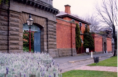 Federation University Historical Collection
Photograph - Photograph - Colour, Former Ballarat Gaol Gates and Warden's Quarters, 2001, 1991
The Ballarat Gaol operated between 1862 and 1965. The complex was based on a central hall from which radiated wings of cells. This meant one guard could stand in the centre of the hall and see all the cells. Most of the gaol was demolished to allow the School of MInes Ballarat to expand. The remaining structures at the site include the main gate, the Warden's Residence, shown in the photo, and the Governor's Residence. These buildings are now used by Federation University. The Warden's Residence is home to the Australian Centre for Research into Injury in Sports and its Prevention.Colour photograph of the main gate of the former Ballarat Gaol and the Warden's Quarters. The gate features a beautifully executed arch keystone of basalt and appears to be cut from one single block of stone. The two storey Warden's Quarters are to the right of the gates.ballarat gaol, lydiard street south, ballarat school of mines, cells, guard, warden's residence, governor's residence, federation university -
Federation University Historical Collection
Photograph - Black and White, Former Ballarat Library, c1960
First known development on this site was the establishment of the Government Camp from the early 1850s. It was established to accommodate officials, troopers and police who were needed to administer the goldfields. Some permanent buildings were constructed. Lack of materials and bad weather prolonged the building of more permanent buildings and most men were still living in tents. Area was known as Camp Reserve. In 1864 a subdivision map shows the reserve be used for Public Buildings. Library applied for land on corner of Sturt and Camp Streets in 1878. 1880s plans show section of the reserve be used for a Free Library and Reading Room. Lease was granted and the old mining boardroom was initially used. Land for additional building to house a Museum and Art Gallery sought and agreement reached in 1882-3. Compensation paid to owners and library granted the land. Plans for a new library building with tower and lantern roof abandoned due to lack of funds. It wasn't until 1895 that a solution to funding was found and the library was able to begin constructing the complex of buildings on the Free Library Reserve. A number of changes have occurred since 1910s - the Classical Revival facade replaced with an angled facade in a stripped Classical style with Art Deco features and high parapet. Building is now part of Federation UniversityPhotograph of former library. Shows a two-storey rendered brick building in a Classical style. Some Art Deco features. Central pair of double windows with single window either side. High parapet above.government camp, goldfields, camp reserve, free library, reading room, sturt street, camp street, museum, art gallery, troopers, police, barracks, camp street -
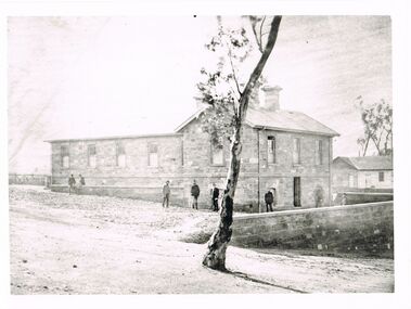 Bendigo Historical Society Inc.
Photograph - WES HARRY COLLECTION: POLICE BARRACKS, ROSALIND PARK
... Back and white copy: stone building, two storey in front...: stone building, two storey in front, single behind. Police ...Back and white copy: stone building, two storey in front, single behind. Police Barracks, Rosalind Park.Batchelderplace, building, police barracks -
 Bendigo Historical Society Inc.
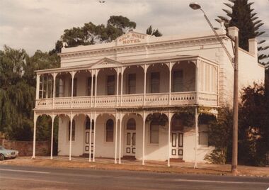
Photograph - BENDIGO HOTEL COLLECTION: GOLD MINES HOTEL, MARONG ROAD, BENDIGO
Colour photograph: Gold Mines Hotel, Marong Road, Bendigo. Image shows two storey building, verandah top and bottom storey, ornate ironwork on verandah. Single pediment in centre of verandah and also on top of second storey Written on top pediment in gold paint 'Gold Mines Hotel' . Hotel painted white.bendigo, hotel, gold mines hotel -
 Bendigo Historical Society Inc.
Photograph - JORDAN COLLECTION: PHOTO OF ST AIDENS ORPHANAGE, BENDIGO
Black and white photo of St Aidens Orphanage, Bendigo. Three storey brick building. Appears to be a celebration event as a number of people can be seen on the lawns. Single child in photo in mid-field.bendigo, institutions, st aidens orphanage -
 Kew Historical Society Inc
Photograph - 'Mandalay', 3 Molesworth Street (Kew), 1979
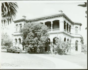
'Mandalay' at 3 Molesworth Street, Kew was originally named 'Kaikoura'. Pru Sanderson's 'Kew Urban Conservation Study' (1988) describes the house as: "The first documentary evidence of this property records that William Dawson was the original owner and occupier of this substantial two-storey mansion, built at the outset of the economic depression of the 1890s. Having an initial N.A.V. of £120 4, the house was occupied by Dawson until at least 1904. This two-storeyed rendered house is Italianate in styling and is dominated by a two-storeyed loggia that spans two facades. At ground floor level it is supported on coupled cast iron colonettes and above has single colonettes that support stilted segmental arches. The house is quite typical of its time, however it bears a strong resemblance to 39 Sackville Street probably by Beswicke and Coote (q.v.), and 'Kawarau'.in Hawthorn, designed by Coote. The similarity of these buildings and the fact that Beswicke and Coote called tenders for a house in Molesworth Street, both suggest that this house was also by that firm.Large original, black and white print positive photograph of 3 Molesworth Street, Kew The two storey Italianate mansion has a double loggia and two bay windows on the side of the property. A car is parked in front.manadaly - molesworth street (kew), historic houses -- kew, italianate architecture -- kew (vic.), kaikoura -- molesworth street -- kew (vic.), beswicke & coote -
 Williamstown Botanic Gardens- Hobsons Bay City Council
Photographs - Williamstown Botanic Gardens, 1936
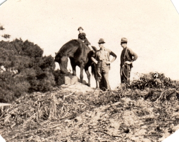
Ernest Anderson (head gardener) and Harry (gardener) worked at Williamstown Botanic Gardens. The Anderson family lived in the curators lodge on the grounds in the 1930s. Horses were used at the gardens until the 1960s when the council bought a truck. Mr Biggs drove as Mr Anderson did not have a licence. He rode his bike to the Town Hall every Friday to put in the time sheets. The collection is the only known photos of the Gardens working horses and demonstrates Edwardian Municipal gardening techniques that continued into the 1960s. They are photographic evidence of the planting styles, species choices and structures. Details inscribed on the reverse of some of the photos confirm names of staff at this time. Photo 13 (m) m: Only known photo of Ernest Anderson to be held by the Gardens2013.001.a-l is a collection of 12 small format photographs from the Anderson family album dated from 1917-1936 plus one large image of donor's wedding c1953. Ernest Anderson (head gardener) and Harry (gardener) worked at Williamstown Botanic Gardens. The Anderson family lived in the curators lodge on the grounds in the 1930s. Photo 1 (a) Sepia photo of young girl (Chic Anderson) on horse with no saddle. Two men, with hands on hips, standing alongside wearing hats. All are on a small hill (a compost heap) with a shrub on the left of the image. Photo 2 (b) Young girl and horse standing on the top of a small hill (compost heap). Girl has short hair and is wearing a jumper, skirt and long socks. Horse has no saddle and has its head down as if to eat. Photo 3 (c) Horse and foal standing in a fenced enclosure. Part of yard is paved. Horse has a white blaze and white feet. Foal has white blaze and white legs and is looking up at the horse. Photo 4 (d) Horse pulling a mower. Two men standing with mower. One is holding mower, the other the reins of the horse. Both men are wearing hats, with one wearing a vest. Horse has hessian wrapping on his hooves. Photo 5 (e) Horse and man. Horse has a rope bridle. Man holding bridle and is dressed in trousers, shirt, cardigan and hat. They are in front of a hedge and closed timber gate. Tall palm is in background. Horse is side on to the camera. Photo 6 (f) Man and horse standing in front of hedge and open timber gate. Palms in background. Man wearing trousers, shirt, vest, tie, hat. Trousers look to be tucked into boots. He is looking at the horse. The horse is facing the camera. Photo 7 (g) Three horses looking over a picket fence. All with a white blaze. There is a timber wall with a window to the right of the photograph. A man’s arm holding something is seen on the right of the photo. Photo 8 (h) Large palm tree, understorey of shrubs with two palms in the background. Photo 9 (i) Scene of the Gardens. Path dividing at a conifer tree. Woman in long skirt and hat looking up at the conifer. Different varieties of palm trees with understorey of shrubs. Photo 10 (j) Garden bed of Dahlias surrounded by a wire fence. Palms and other trees in background. Photo 11 (k) Avenue of tall palm trees with under storey of shrubs. Photo has angles cut at top corners and two large crease marks at the bottom right hand corner. Photo 12 (l) Set of cast iron gates – double carriage gates with single pedestrian gates on either side and supported by four cast iron posts with ornamental finials on top. Photo 13 (m) Ernest Anderson and daughter Chic prior to her wedding. Ernest is holding his gloves in his left hand and Chic’s hand with his right. Palms trees in the background. Photo 1 (a) 'Ern & Harry / May 8th 1936' Photo 2 (b) ‘Jack aged 36 / Chic 5 years / (unclear) 1936’ Photo 3 (c) ‘foal born in / back shed’ Photo 4 (d) ‘The Olde Firm / Jack Ernie Harry / 1917’ Photo 6 (f ) ‘Before the / council provided / a truck all / work was done / with the horses’ Photo 7 (g) ‘our work horses’ Photo 9 (i) ‘Panoramic view of Gardens / looking South from Lodge / Wms Town Botanical Gardens / 15-10-17’ Photo 12 (l) ‘Gates Public Gardens’hobsons-bay-city-council, curator, lodge, horse, transport, dahlia, compost, anderson, williamstown, botanic, gardens, williamstown-botanic-gardens, hobsons-bay, hobsons, edwardian, gardening, 1936, 1917, -
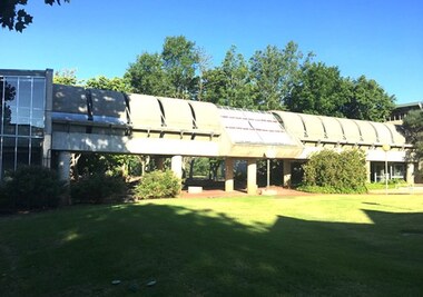 Wodonga & District Historical Society Inc
Photograph - Clyde Cameron College, Wodonga, 1976 - 1977
The Former Clyde Cameron College was constructed in 1976-7 as a residential training college for trade unions. The college was commissioned and operated by the Trade Union Training Authority (TUTA) from 1977 until its closure in 1996. The design team was the Architects Group and the Commonwealth Department of Construction was responsible for site supervision and contract administration. The building was constructed jointly by Costain Australia Ltd and M.A. & A.W. Chick of Albury. The foundation stone was unveiled by Clyde Cameron in 1976. He was the serving Federal Minister for Labour from 1972 to 1974, Minister for Labour and Immigration 1974 - 1975 and Minister for Science and Consumer Affairs in 1975. The building was completed at a cost of $6.5 million in 1977. It was one of the most controversial of the 1970s due to its Brutalist architecture. The complex consists of a series of wings of one and two storeys linked by pre-cast concrete pipe walkways. Inside the wiring and pipes were left exposed and painted in primary colours to show off the workmanship. The accommodation, most of them single rooms, were able to house 70 students at a time with 1200 students to go through each year. The training college was closed in 1996 and was taken over by the Murray Valley Private Hospital and Murray Valley Radiation Oncology. In July 2008, the Royal Australian Institute of Architects awarded its “25 Year Award for Enduring Architecture” to Clyde Cameron College. The building was again sold in February 2023, although its future is yet to be determined.The former Clyde Cameron College is of architectural significance as an example of the late twentieth century Brutalist style and the work of Victorian architect and lecturer Kevin Borland. It also has historical significance for its association with the Trade Union movement, and the Whitlam government, including its role as Australia’s first residential trade union training facility. It is a physical reminder of the influence of the union movement in the 1970sA collection of colour photographs documenting the buildings at the former Clyde Cameron College, Wodonga.clyde cameron, trade union training, clyde cameron college -
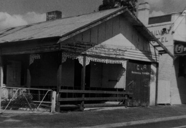 Linton and District Historical Society Inc
Photograph, LDHS Resource Centre Before Restoration, Linton, 1987, 1987
Black and white photograph showing front of dilapidated single fronted building next to two storey brick building.ldhs resource centre, nelson bros. funeral parlour, buildings -
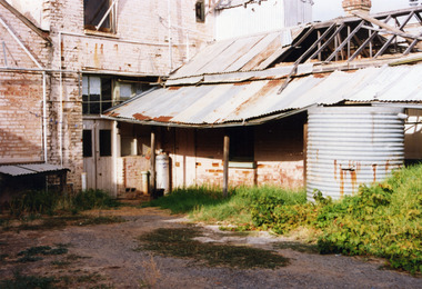 Charlton Golden Grains Museum Inc
Photograph, Brownjohn, Reg, Rear of Johnson's Bridge Store c. 2000, c.2000
Derelict rear of building built as Bridge Store in 1872 for Peter Johnson, later Wylie's Building and a furniture store. Photo taken for the Museum.Colour photograph of the rear of an old, brick two storey building. Building appears derelict and disused. Not all the building is in the photo. Old rainwater tank on RH side, part of the roof is missing and the beams are exposed. Gas tank/hot water service in corner in the centre of the photo. Single door to the right of the gas tank and double doors to the left.bridge store, peter johnson, wylie's building, business -
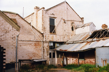 Charlton Golden Grains Museum Inc
Photograph, Brownjohn, Reg, Rear of Johnson's Bridge Store c. 2000, c.2000
Derelict rear of building built as Bridge Store in 1872 for Peter Johnson, later Wylie's Building and a furniture store. Photo taken for the Museum by R. Brownjohn.Colour photograph of the rear of an old, brick two storey building. Building appears derelict and disused. Part of the roof is missing on the lower section and the beams are exposed. Verandah is sagging. Gas tank/hot water service in corner in the centre of the photo. Single door to the right of the gas tank and double doors to the left. One large and one small window in the upstairs section. Chimney on LH side of upper storey.bridge store, peter johnson, wylie's building, charlton, business -
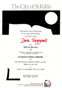 St Kilda Historical Society
Ephemera - Invitation, Official Opening of extension to St Kilda Public Library, 1993
Invitation to the official opening of an extension to the St Kilda Public Library by the Victorian Minister for the Arts, the Hon Haddon Storey QC MLC, on 19 December 1993. The floor area of the library was enlarged to include a new entry, ramp, and a pedestrian thoroughfare extending between Carlisle and Duke streets. The original entry was was blocked and a bluestone screen wall, evoking the form of an open book, was introduced to the west of new entry. Single sheet of white paper printed in grey, black and red, with St Kilda logoDon Taggart (invitee) st kilda town hall, st kilda town hall fire -
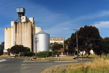 Charlton Golden Grains Museum Inc
Photograph, Charlton Shire, Charlton Flour Mill, c.1987
A previous mill had operated in Charlton by Mr. W.E. Foreman on the banks of the Avoca River and was acquired in 1919 by Noske Bros. The present Flour Mill was built by Noske Bros and opened in May 1927. It was taken over by the Grain Elevator Board in the 1970s. Colour photograph of Charlton Flour Mill and silos. Intersection of Kaye & Davies Streets in the foreground. One large silver silo and three taller greyish concrete silos to the left. Three other cream coloured silos behind. There are pipes and sheds on top of the silos. There is a cream single story building to the right of the silver silo and a multi-storey building behind with eight window in the upper level. There is a small red brick building on the far left of the photo.w.e. foreman, noske bros, flour mill charlton, business, industry -
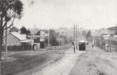 Ballarat Tramway Museum
Photograph - Black and White from a postcard of Bendigo - Mitchell St, 1910s
Photograph shows a Bendigo ESCo tram climbing the hill in Mitchell St to where the double track converged into single track before crossing over the railway line. Photo is looking west. Has a two storey hotel on the right. See item 9080 for a coloured version.Yields information about Mitchell St Bendigo and ESCo trams.Black and White photograph from a postcard of Bendigo - Mitchell Sttramways, trams, bendigo, esco, mitchell street -
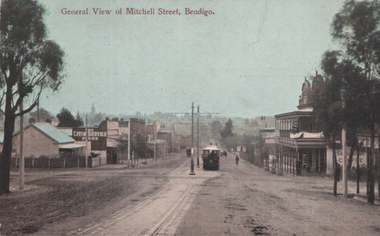 Ballarat Tramway Museum
Postcard, WTP, "General view of Mitchell Street Bendigo", 1910s
The photograph shows a Bendigo ESCo tram climbing the hill in Mitchell St to where the double track converged into a single track before crossing over the railway line. The photo is looking west. Has a two-storey hotel on the right. See item 8452 for a black-and-white version.Yields information about Mitchell St Bendigo and ESCo trams.Postcard - colour divided back, unused.tramways, trams, bendigo, mitchell st -
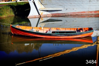 Flagstaff Hill Maritime Museum and Village
Vehicle - Vessel, Dinghy, Proudfoot's Boat, c. 1885
... business on the Hopkins River. The early single-storey sections ...This boat or dinghy is one of a few remaining boats made for Proudfoot’s Boathouse, 2 Simpson Street Warrnambool, on the Hopkins River, in about 1885. It was one of many rowing, fishing, sailing and picnic boats that were available to hire. Proudfoot’s Boathouse, a beautiful Victorian Period building, was designed, built and established by Thomas Proudfoot. He applied to build a boat jetty in 1885. He died in 1900 and his wife Catherine took over, running it for many years. Later her son Bruce and after that her granddaughter Ena Hunt and her husband took over; it remained in the family until 1979. Proudfoot’s was a very popular tourist destination for visitors coming from Melbourne to fish and row and enjoy afternoon tea. The buildings, including the ‘U’ shaped jetty and tearooms, were restored and modified in the 1990s by the Warrnambool Sports Club, under the control of the Warrnambool City Council. The dinghy was brought to Flagstaff Hill in about 1992 and restored to its original condition and painted in traditional paint colours of orange with dark green gunnel and black and gold pinstripes. Since that time it has been painted by Flagstaff Hill's boatbuilder.This dinghy, Proudfoot’s Boat, is significant for its association with Proudfoot’s Boathouse, which is listed on the Victorian Heritage Register, VHR H0620. “Proudfoot's Boathouse on the Hopkins River near Warrnambool is an outstanding example of a late-19th century boathouse complex with associated residences and jetties. Thomas Proudfoot first applied for a jetty licence in 1885 with a view to establishing a boating business on the Hopkins River. The early single-storey sections are thought to date from this period. The two storey second stage probably dates from 1893 when additions were constructed. The entire complex was designed and built by Proudfoot himself. The business remained in the Proudfoot family until 1979. The buildings were modified in the 1990s in the process of creating a sporting club on the site. Proudfoot's Boathouse is of architectural, historical and social significance to the State of Victoria. Proudfoot's Boathouse is of architectural significance as perhaps the finest example of a 19th-century boathouse in Victoria. Although recent modifications have reduced the intactness of the buildings, many original features remain. The beautifully ornamented buildings still provide an attractive instance of 19th-century leisure facility architecture. Proudfoot's Boathouse is of historical significance as an example of late-Victorian recreational and tourist facilities. Boathouses were popular 19th-century tourist and recreational attractions, providing refined and healthy activity. This boathouse shows the early realisation of the tourism and leisure potential of seaside towns such as Warrnambool, a potential that has become increasingly important as port uses have ceased and other industries have been subjected to financial pressure. Proudfoot's Boathouse is of social significance because it illustrates the continuity of the attraction of this kind of leisure facility. Although the glory days of the boathouse were in the 19th century, those that survive continue to be well patronised. Proudfoot's Boathouse has been an important recreational facility and attraction for tourists flocking to the Hopkins River, one of the State's most popular boating and fishing resorts, since 1885.” (Statement of Significance is from the Victorian Heritage Register)Wooden vessel or boat, called a dinghy, known as Proudfoot’s Boat. Paint work is orange with dark green gunnel and black stripe. The rowboat is propelled by oars and has two pair of thole set into the gunnel (gunwale) to hold the oars in place and to serve as a fulcrum when rowing. The boat is dated around 1885. flagstaff hill, warrnambool, shipwrecked coast, flagstaff hill maritime museum, maritime museum, shipwreck coast, flagstaff hill maritime village, great ocean road, small marine vessel, dinghy, proudfoot's boat, proudfoot's boathouse, picnic boat, orange and black boat