Showing 22573 items matching "victoria street"
-
 Warrnambool and District Historical Society Inc.
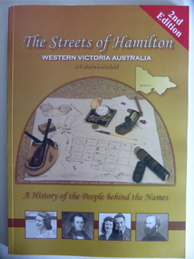
Book, Streets of Hamilton, 2007 (revised and reprinted 2009)
... This is a book providing information on the streets...Front Cover: ‘2nd Edition’ ‘The Streets of Hamilton... This is a book providing information on the streets of Hamilton, Victoria ...This is a book providing information on the streets of Hamilton, Victoria and the origin of the names. Hamilton is a city in Western Victoria at the intersection of the Glenelg Highway and the Henty Highway. European settlement began with the arrival of pastoralists following the 1836 explorations of Major Thomas Mitchell. The Wedge family in 1839 had the property ‘The Grange’ which covered the site of Hamilton today. The town was gazetted in 1851 and named after a place in Scotland. Hamilton Victoria is the centre of a sheep-grazing and agricultural district. The book won an award in the 2008 Victorian Community History Awards. This book is of interest as it gives information on the Hamilton streets and the origin of their names. The history of Hamilton is of particular interest to those also living in the Western District. The book will be a useful research tool. This is a soft cover book of 174 pages. The back cover has a white background with black and white photographs of five local Hamilton people. The front cover has a yellow and brown background with black and white photographs of five local Hamilton people, an outline of a map of Victoria and a photograph of a map of the Hamilton area with some artefacts placed on the map. The book contains an Introduction, a Preface, a Foreword, an Early Days Overview, a list of Contents, a list of the streets in alphabetical order with information on the origin of the names, two Appendices and an Index. The book has many black and white photographs and sketches. Front Cover: ‘2nd Edition’ ‘The Streets of Hamilton’ ‘Western Victoria Australia’ ‘By John McKay’ ‘A History of the People behind the Names’hamilton, victoria, john mckay, street names of hamilton, warrnambool -
 Marysville & District Historical Society
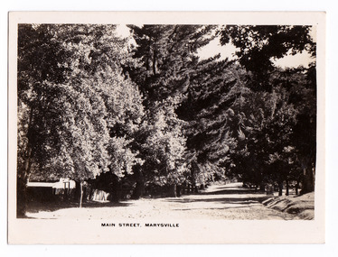
Photograph (item) - Black and white photograph, Rose Stereograph Company, Main Street, Marysville, 1913-1967
... An early black and white photograph of the main street...An early black and white photograph of the main street... and white photograph of the main street in Marysville in Victoria ...An early black and white photograph of the main street in Marysville in Victoria. An early black and white photograph of the main street in Marysville, Victoria. This street is now known as Murchison Street. The photograph was also used to produce the Rose Series postcard P. 4927.marysville, victoria, photograph, murchison street, p. 4927, rose series postcard, souvenir, rose stereograph company -
 Marysville & District Historical Society
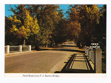
Postcard (item) - Colour postcard, Nucolorvue Productions Pty. Ltd, Pack Road from F.J. Barton Bridge, Pre 2009
... Murchison Street in Marysville in Victoria.... of Marysville. marysville f.j. barton bridge murchison street victoria ...A colour photograph of Murchison Street from the F.J. Barton Bridge in Marysville in Victoria.A colour photograph of Pack Road from the F.J. Barton Bridge in Marysville in Victoria. Labeling is incorrect. The view is looking down Murchison Street from the F.J. Barton Bridge. The F.J. Barton Bridge was named after Frederick John Barton. The Barton Family were amongst Marysville's first pioneering families. This postcard was published by Nucolorvue Productions as a souvenir of Marysville.NU-COLOR-VUE/ OF / AUSTRALIA MARYSVILLE, VICTORIA. Pack Road from F.J. BARTON/ BRIDGE. PLACE/ STAMP/ HERE POST CARD NCV.172 - NUCOLORVUE PRODUCTIONS PTY. LTD./ COPYRIGHT Printed in Australiamarysville, f.j. barton bridge, murchison street, victoria, postcard, souvenir, nucolorvue productions, fj barton -
 Bendigo Historical Society Inc.
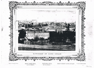
Photograph - LONG GULLY HISTORY GROUP COLLECTION: TOWNSHIP OF LONG GULLY
... Bark Hill Victoria Hill Main Street Long Gully Forbes & Holmes ...Black & white photocopy of a photo of the Township of Long Gully. Print has a decorative frame around it. Photo taken by N J Caire, Sandhurst, which is printed just inside the frame. A Carey & Wenborn's Print, printed on the left under the frame, then Iron Bark Hill, in the distance. Victoria Hill, in the distance. Main Street Long Gully. Forbes & Holmes, Agents. Photo shows a road and a picket fence in the foreground with houses, mine chimneys, poppet legs and mine buildings in the background. On the left horizon an area has been drawn around. Written on the back is: 1857 Started Methodism on the Site of the Present St Mathews. 1853 Methodism Started services were held open air. St Mathews Church Built 1883. Sunday School 1896 Long Gully Methodist Church 1877 Sunday School 1871 Kindergarten 1905 Long Gully Post Office Built Early Methodist Church Built Creeth St & Eaglehawk Rd was a Wooden Building got burnt down. (Ethel Leggo) Another copy of this photo 11010.44N J Cairebendigo, history, long gully history group, the long gully history group - township of long gully, n j caire, carey & wenborn, iron bark hill, victoria hill, main street long gully, forbes & holmes, st mathews, long gully methodist church, long gully sunday school, long gully kindergarten, long gully post office -
 Whitehorse Historical Society Inc.
Map, Cadastral map, ca 1955
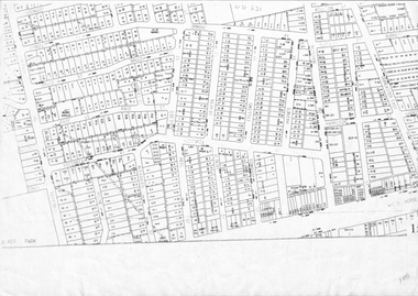
... street page street victoria avenue mitcham road whitehorse road ...Cadastral map showing house and lot numbers (ca 1955) in Mitcham.plans, ormond avenue, mitcham, hardwood court, bruce street, page street, victoria avenue, mitcham road, whitehorse road, dunlavin road, doncaster east road, harrison street, william street, alexander street, fellows street, peel street, milne street, albert street, edward street, shirley court, burnett street, haines street -
 Rutherglen Historical Society
Image, Main Street, East Rutherglen, 1909
... Coloured postcard showing Main Street, Rutherglen...-country main street victoria hotel Coloured postcard showing Main ...Coloured postcard showing Main Street, Rutherglen with the Victoria Hotel in the foreground.main street, victoria hotel -
 Rutherglen Historical Society
Image, c1980
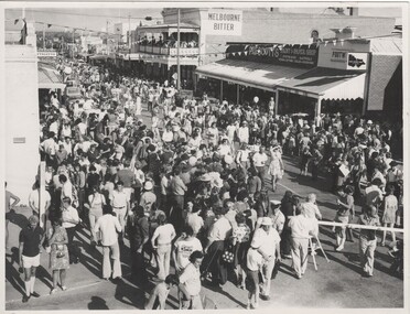
... -country rutherglen wine festival main street victoria hotel ...Black and white photograph of crowd of people in Main Street for the Wine Festival.On back of photo: handwritten "Carracher", rubber stamp "Rutherglen Historical Society Inc." rutherglen wine festival, main street, victoria hotel, prescott's paint and paper shop -
 City of Ballarat Libraries
Photograph - Card Box Photographs, Unveiling of the Boer War Statue, Ballarat 1906
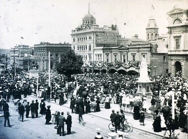
... Statue Queen Victoria Statue Sturt Street Persons Monument ...People stand around the Queen Victoria statue watching the unveiling of the Boer War statue.boer war statue, queen victoria statue, sturt street, persons, monument, building, public, commerical -
 City of Ballarat Libraries
Postcard - Card Box Photographs, Statue of Queen Victoria
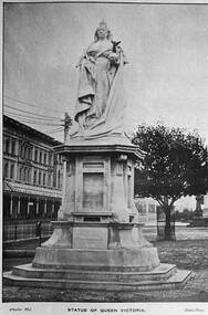
... Victoria Statue Sturt Street Ballarat Statue of Queen Victoria ...The statue is located on Sturt Street in front of the Town Hall. Plate 16 Black Photo Series.queen victoria statue, sturt street, ballarat -
Kew Historical Society Inc
Archive (Sub-series) - Subject File, BOYD, Robin (1919-71), 1980-2015
... sources. australian archiecture - kew - victoria 21 redmond street ...Various partiesReference, Research, InformationSecondary Values (KHS Imposed Order)Subject file containing newspaper articles/advertisements relating to the Australian architect Robin Boyd, including the house at 21 Redmond Street.australian archiecture - kew - victoria, 21 redmond street (kew), robin boydaustralian archiecture - kew - victoria, 21 redmond street (kew), robin boyd -
 Bacchus Marsh & District Historical Society
Map, Main Road and Gell Street Allotments
... allotments of land in Gell Street for sale. Bacchus Marsh Victoria ...This map shows allotments of land along Gell Street Bacchus Marsh running between Main Road (now called Main Street) and Lerderderg Street. The total area of the map encompasses Main Road, Church Street, Lerderderg Street and Gell Street. 36 allotments of land are shown. Three allotments which connect to Main Road are shaded in pink. The date of the map has not been established but the National Bank building erected in 1865 near the Border Inn is indicated which indicates that the map dates from after 1865. Reports in the Bacchus Marsh Express newspaper on 5 March 1870, page 2, column 6 announced building lots in Gell Street had been withdrawn from sale by the agent J.E. Crook. Later reports in the Express on 1 November 1873, page 2, column 2 advertised 14 allotments of land in Gell Street for sale. Single page map showing allotments of land along the Main Road (Main Street) and Gell Street areas of Bacchus Marsh. Part of a set of maps which are pasted into a bound volume containing 76 maps or plans in total. High resolution digital image stored on BMDHS computer network. bacchus marsh victoria maps, gell street land allotments, main street land allotments -
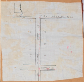 Bacchus Marsh & District Historical Society
Map, Lord Street, Bacchus Marsh. Undated
... Bacchus Marsh Victoria Maps Lord Street Bacchus Marsh Maps ...A small single page map showing the line of Lord Street Bacchus Marsh between Ballarat Road (Main Street) and Simpson Street. Part of a set of maps which are pasted into a bound volume containing 76 maps or plans in total. High resolution digital image stored on BMDHS computer network. bacchus marsh victoria maps, lord street bacchus marsh maps -
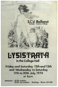 Federation University Historical Collection
Poster, 'Lysistrata ' Production Poster, 1974, 1974
... Gillies Street, Ballarat, Victoria, Australia... of victoria, ballarat gillies street liz stubbs joy dunstan jenny tait ...White paper poster with black text and drawing of a woman in front of some gruesome looking people. The the poster was for a State College Victoria (formerly Ballarat Teachers' College) production held at the college hall in Gillies Street, Ballarat.Front: "S.C.V. Ballarat, formerly - Teachers Collge, Lysistrata, in the College Hall, Friday and Saturday, 12th and 13th, and Wednesday to Saturday, 17th to 20th July, 1974, at 8 pm, Admission - $1.00 Students, $1.50 non students, Bookings - Phone 341 202" Back: "Lysistrata, by Aristophanes, CAST LIST, Lysistrata: Liz Stubbs, Kalonike: Joy Dunstan, Lampito: Jenny Tait, Myrrhine: Denise Maroney, Stratyllis: Ann Bilston, Interviewer: Tina Conroy, Kinesias: Michael Russo, Police Commisioner: Tony Ryan, Spartan Ambassador: Terrence Dorian, Spartan Herald; Shane Quick. WOMEN'S CHORUS, Sue Richards, Tina Conroy, Ann Bilston, Anne Giles, Glenda Hamilton, Janette Marshall, Gillian Hogan, Janine Grieg, Robyn Stanesby, Stephanie Buchanan, Janeen McCullough, Wendy Gray, Elizabeth Evans, Jenny Tait (Leader of Spartans), Mary Staindl, Barbara Price. MEN'S CHORUS, John Rowe, Stephen Schneider, Chris Slater, Peter Hassell, Errol Elbourne, Peter Orford, Kieth McDougall,Terrence Dorian, Robbie Eastcott, Shane Quick, Gary Oliver. MUSIC, Piano: Robbie Eastcott. Drums: Alex Traianou. Congas: David Murphy. Rhythm Guitar: Kim Hatcher. Bass Guitar: Shane Quick. Clarinet: Steve Albon. Flute: Tina Conroy. Acoustic Guitar: Tony Ryan. TECHNICAL CREW, Lighting: Austin Rickell, Sound: Stuart Tolliday, Keith McIvor, Design: Bruce Miller, Terrence Dorian, Set Construction: Bruce Miller, Terrence Dorian, Ken Jones, Choreograph: Cheryl Brown, Costumes: Gillian Hogan, Mary Staindl, Props: Denise Maroney, Jenny Tait, Publicity and Front of House: Ruth Newall. ACKNOWLEDGEMENTS, Meena Bazaar for the Jug, Turner Audio Systems. DIRECTED BY, Miichael D. Edwards. DIRECTOR'S NOTE, The sexual power of women is all persuasive. If, as Germaine Greer says, they stopped loving the victors, there would be genuine revolution. The idea of a sex strike to stop a war seems preposterous.... What else is left to the aware but politically emasculated woman? Aristophanes, like us, had been appalled by a pointless and hopeless war. Outrageous indignation had failed to stop it - so he resorted to comic absurdity; perhaps to shame the warmakers. Our version of the play is colloquial and probably ' in vogue'. It is colorful, musical, flippant, and not a little risque. It is, however, based on an awareness of the power of sex roles and the arrogance of a male-dominated society and a profound sense of frustration at the apparently immovable forces that make our wars and enact repression in all its forms."ballarat teachers' college, production, state college of victoria, ballarat, gillies street, liz stubbs, joy dunstan, jenny tait, denise maroney, ann bilston, tina conroy, michael russo, tony ryan, terrence doran, shane quick, sue richards, anne gillies, glenda hamilton, janette marshall, gillian hogan, janine grieg, robyn stanseby, stephanie buchanan, janeen mccillough, wendy gray, elizabeth evans, mary staindl, barbara price, john rowe, jeff moore, stephen schneider, chris slater, peter hassell, errol elbourne, peter orford, keith mcdougall, terrance doran, robbie eastcott, gary oliver, david murphy, alex traianou, kim hatcher, steve albon, austin rickell, stuart tolliday, keith mcivor, bruce miller, ken jones, cheryl brown, ruth newall, michael d. edwards, norman lindsay -
![Map, Plan of Subdivision [Allotments along Lerderderg, George and McFarland Streets]](/media/collectors/5e461d8021ea67224c82f2a1/items/675d7243165f146b8adfc656/item-media/675d72d7165f146b8adfc859/item-fit-380x285.jpg) Bacchus Marsh & District Historical Society
Bacchus Marsh & District Historical SocietyMap, Plan of Subdivision [Allotments along Lerderderg, George and McFarland Streets]
... Victoria Maps Lerderderg Street Land Allotments McFarland Street ...This map shows allotments of land on the northern side of Lerderderg Street from Gisborne Road through to the approximate site of the present day Bacchus Marsh Primary School. There are also allotments shown on the southern side of McFarland Street between George Street and Gisborne Road. Larger allotments of land are shown extending northwards towards Masons Lane. Inscribed at the top of the map are the words, 'Plan of Subdivision of Cr Pors (Crown Portions) 12 & 13 & Allotments 1,2,3,4, Block 3, Parish of Korkuperrimul, County of Bourke'. The date of the map has not been established but the absence of the Bacchus Marsh Primary School on the map suggests it may have been produced prior to 1865 when the primary school was built in Lerderderg Street.Single page map showing house block size land allotments in the Lerderderg, George Street and McFarland Street area of Bacchus Marsh with larger allotments north of this area towards Masons Lane also shown. Scale 150 feet to 1 inch. Part of a set of maps which are pasted into a bound volume containing 76 maps or plans in total. High resolution digital image stored on BMDHS computer network. bacchus marsh victoria maps, lerderderg street land allotments, mcfarland street land allotments -
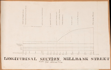 Bacchus Marsh & District Historical Society
Drawing, Longitudinal Section Millbank Street Bacchus Marsh circa 1905
... . Bacchus Marsh Victoria Maps Millbank Street Bacchus Marsh Single ...Millbank Street is a short street located close to the central business and shopping area of Bacchus Marsh. In the early 1900s works to improve the drainage of the street were discussed and planned by Bacchus Marsh Shire Council. This plan is most probably the plan discussed at a Shire Council meeting in April 1905. Single page plan showing a longitudinal section view of MIllbank Street running from Clarinda Street to Grant Street in Bacchus Marsh. The names of Millbank Street property owners, Cain, Shelley, Oliver and Ramsay are marked on this plan. Scale: Vertical 10 feet to 1 inch. Horizontal: 100 links to 1 inch Part of a set of maps which are pasted into a bound volume containing 76 maps or plans in total. High resolution digital image stored on BMDHS computer network. bacchus marsh victoria maps, millbank street bacchus marsh -
 Bacchus Marsh & District Historical Society
Map, Plan of Survey of Part of Crown Allotment 9, Parish of Korkuperrimul, 1890
... . Elmore, Bacchus Marsh Victoria Maps Clarke Street Bacchus Marsh ...This map documents a transfer of an allotment of land in Clarke Street Bacchus Marsh in 1890. Clarke Street is located on the eastern side of Bacchus Marsh not far from Main Street and Crook Street. It is now known as Candeloro Street. The map indicates J. Booth as the owner of the land and H. Simpson as the occupier. Next to this allotment is a an allotment of land owned by J. Elmore,Single page map showing Crown allotment 9, Parish of Korkuperrimul, County of Bourke. Scale 100 feet to inch. Part of a set of maps which are pasted into a bound volume containing 76 maps or plans in total. High resolution digital image stored on BMDHS computer network. At bottom of map: I hereby certify that I have made this survey expressly for the purpose of an application under the Transfer of Land Statute that this plan is correct. Barry B???, Lic. Surveyor, 16.10.90bacchus marsh victoria maps, clarke street bacchus marsh maps -
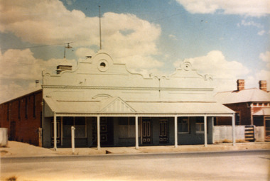 Charlton Golden Grains Museum Inc
Photograph, Victoria Hall, Armstrong St Charlton c. 1960, c.1960
... Armstrong Street, Charlton, Wimmera Mallee, Victoria.... 1960. E. Miles S. Rosewall Victoria Hall Armstrong Street ...Victoria Hall, Armstrong St Charlton was built for E. Miles in 1884. Sid Rosewall's house is on the right. This photo taken c. 1960.Colour photograph of a single storey, triple fronted red brick building. The front of the building is painted. There are double doors for the main entrance and three single doors - one to the left and two to the right of the main doors. There is a large, ornamental parapet wall on the front of the building with a flag pole. A wide verandah runs the length of the front of the building with a pitched section over the main entrance. The LH side of the building is unpainted and has four windows high on the wall. A red brick building is partially visible on the RH side of the photo. It has two chimneys and iron roof.e. miles, s. rosewall, victoria hall, armstrong street, charlton, halls -
Canterbury History Group
Book, Chris McConville and Associates, Camberwell Conservation Study: Environmental History, 12 December 1989
... Camberwell City of Monomeath Avenue Victoria Avenue Logan ...Draft report prepared for the City of Camberwell and submitted to the Advisory Committee on 12 December 1989. Volume 1.Spiral bound; 136 pages; includes B&w sketches, maps and photocopies of photosnon-fictionDraft report prepared for the City of Camberwell and submitted to the Advisory Committee on 12 December 1989. Volume 1.camberwell city of, monomeath avenue, victoria avenue, logan street, duncan & weller, canterbury, canterbury road, canterbury gardens, canterbury concert committee, fountains, rotundas, logans paddock, keats street, golding family, mellor> l a, chaucer crescent -
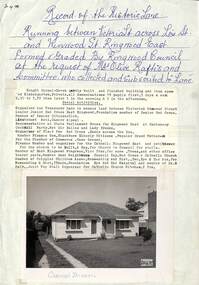 Ringwood and District Historical Society
Memorabilia, Record of Historic Lane and formation of Carmel Haven Kindergarten, Ringwood East, Victoria - 1956
... between Victoria Street across Lois Street and Wenwood Street... the historic lane running between Victoria Street across Lois Street ...Buying of Carmel Haven and formation of kindergarten after Mrs. Olive Raftis and a committee bought the historic lane which ran between Victoria St. Lois St. and Wenwood St. Ringwood East.Six pages of memorabilia about the historic lane running between Victoria Street across Lois Street and Wenwood Street, Ringwood East formed by Ringwood Council at the request of Mrs. Olive Raftis and Committee who collected and subscribed to the lane, including picture of house bought to use as a Kindergarten. 26269-1. Description of location and photograph with summary of Kindergarten activities 26269-2. Newsletter - Second meeting of ratepayers to discus lane 26269-3. Receipt from Borough of Ringwood for supply of 400 square yards of concrete path Victoria Street to Wenwood Street to Mrs. Raftis 26269-4. Receipt to Committee for 18 yards of gravel for concrete gutter. 26269-5. Receipt to Mrs. O. Raftis £5 with 2d Victoria Stamp Duty attached. 26269-6. List of contributers. -
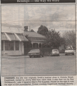 Bendigo Historical Society Inc.
Newspaper - JENNY FOLEY COLLECTION: CHANGES
... : this site was originally Smith's butcher shop in Victoria Street... Smith's butcher shop in Victoria Street, Eaglehawk, owned by Jimmy ...Bendigo Advertiser ''The way we were'' from 1999. Changes: this site was originally Smith's butcher shop in Victoria Street, Eaglehawk, owned by Jimmy Wild from 1924-1939. It was then run by Roy Shuttleworth. Later it became Allen's Pet Supplies. House on the right is now the sight of IGA supermarket.newspaper, bendigo advertiser, the way we were -
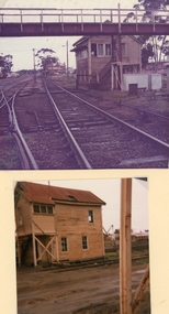 Stawell Historical Society Inc
Photograph, Railway Signal Box No.2 off Doyle and Victoria Streets -- 2 Photos -- Coloured
... Railway Signal Box No 2 off Doyle and Victoria Streets... grampians Railway Signal Box No 2 off Doyle and Victoria Streets ...Railway Signal Box No 2 off Doyle and Victoria Streets. Also called Signal box b.Two colour photographs of Signal box 2 also called Signal box b, beside railway lines.stawell -
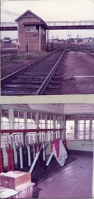 Stawell Historical Society Inc
Photograph, Railway Signal Box No.2 off Doyle and Victoria Streets -- 2 Photos -- Coloured
... Railway Signal Box No 2 off Doyle and Victoria Streets... grampians Railway Signal Box No 2 off Doyle and Victoria Streets ...Railway Signal Box No 2 off Doyle and Victoria Streets. Also called signal box b.Two coloured photographs. One view of the signal box with over pass and rail line. The other view is inside the signal box.stawell -
 Kew Historical Society Inc
Plan - Subdivision Plan, Thornton Estate, 1918
... of the Victoria-street cable tram’. The terms offered purchasers were ten... of the Victoria-street cable tram’. The terms offered purchasers were ten... of the Victoria-street cable tram’. The terms offered purchasers were ten ...The ‘Thornton Estate’ was the final subdivision of ‘Thornton’ in Studley Park Road. Thomas Cubitt Balmain originally owned Thornton, next to John Carson’s ‘Clutha’. Before its final subdivision, the Thomson family owned it. The Estate was a subdivision of 15 residential allotments running between Studley Park Road and Stevenson Street. The allotments faced these streets as well as Thornton Street, which the vendor undertook to make. Contemporary newspaper advertisements advised that ‘The estate possesses many advantages, notably its private and secluded, though convenient, position, splendid frontages and depths, and being close to the electric tram and Kew train, also within easy walking distance of the Victoria-street cable tram’. The terms offered purchasers were ten per cent deposit, with the balance to be paid in ten equal half-yearly payments at a rate of 5 per cent.The ‘Thornton Estate’ was the final subdivision of ‘Thornton’ in Studley Park Road. Thomas Cubitt Balmain originally owned Thornton, next to John Carson’s ‘Clutha’. Before its final subdivision, the Thomson family owned it. The Estate was a subdivision of 15 residential allotments running between Studley Park Road and Stevenson Street. The allotments faced these streets as well as Thornton Street, which the vendor undertook to make. Contemporary newspaper advertisements advised that ‘The estate possesses many advantages, notably its private and secluded, though convenient, position, splendid frontages and depths, and being close to the electric tram and Kew train, also within easy walking distance of the Victoria-street cable tram’. The terms offered purchasers were ten per cent deposit, with the balance to be paid in ten equal half-yearly payments at a rate of 5 per cent.subdivision plans - kew, thornton estate, studley park road -- kew (vic.), thornton avenue -- kew (vic.), stevenson street -- kew (vic.) -
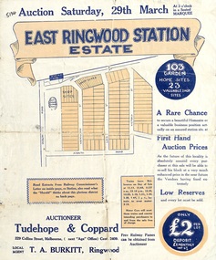 Ringwood and District Historical Society
Flyer, Land Sale Auction Brochure, East Ringwood Station Estate - 1924
... Street, Victoria Street. Auctioneer - Tudehope & Coppard, 229... Street, Wenwood Street, Lois Street, Victoria Street. Auctioneer ...Bi-folded double sided sheet with yellow and blue print advertising auction of retail and residential allotments on Saturday, 29 March (1924), including details of subdivision features and local facilities. Subdivision includes Station Street, Wenwood Street, Lois Street, Victoria Street. Auctioneer - Tudehope & Coppard, 229 Collins Street, Melbourne, Tel. Central 2409, in conjunction with local agent, T.A. Burkeitt, Ringwood, Tel. Ringwood 157. -
 Bendigo Historical Society Inc.
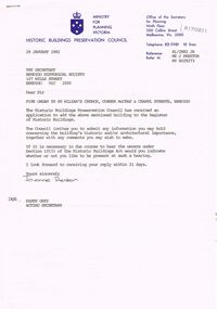
Document - CORRESPONDENCE: THE REGISTRATION (REGISTRATION OF HISTORIC BUILDINGS) OF ORGAN AT ST. KILIAN'S, 29/01/1882
... Ministry for Planning Victoria. 500 Collins Street... for Planning Victoria. 500 Collins Street Melbourne. Correspondence re ...Correspondence re the registration (Registration of Historic Buildings) of organ at St. Kilian's . A letter dated 29/1/1982 from Ministry for Planning, Victoria to the Secretary Bendigo Historical Society (request for any information held regarding importance); b copy of application from the Organ Historical Trust of Australia to ''Add a Building to the Register of Historic Buildings''. Details of the organ are within the application - builder: August Randebrock, Paderborn, Germany , 1871; statement of significance re the organ - 'It is the only large example of a large (sic) 19th C German organ in Australia, such instruments are rare even in Germany. It is of international importance''.Ministry for Planning Victoria. 500 Collins Street Melbourne.church, history, st. kilian's catholic church, bendi, august randerbrock, paderborn, germany. 19th c german organ. -
Tatura Irrigation & Wartime Camps Museum
Photograph - original, Bazeley's Hotel, c 1890's original
... on back: Bazeley's Victoria Hotel, Hogan Street, Tatura....Tatura Irrigation & Wartime Camps Museum 49 Hogan Street ...Very old, part of photograph of Victoria Hotel, owned by Thos Bazeley. Early pioneers of Tatura. Upstairs iron lacework verandah has been removed but Hotel is still standing. 1989. Now known as Sarah and Kate's Victoria Hotel.Original. Very old sepia photograph of Bazeley's Hotel, Hogan Street, Tatura. Two women on balcony, four men standing in front. On cardboard.on back: Bazeley's Victoria Hotel, Hogan Street, Tatura.thos bazeley, victoria hotel tatura -
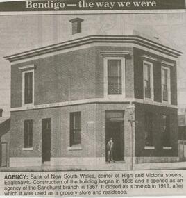 Bendigo Historical Society Inc.
Newspaper - JENNY FOLEY COLLECTION: AGENCY
... : Bank of New South Wales, corner of High and Victoria Streets..., corner of High and Victoria Streets, Eaglehawk. Construction ...Bendigo Advertiser ''The way we were'' from 2000. Agency: Bank of New South Wales, corner of High and Victoria Streets, Eaglehawk. Construction of the building began in 1866 and it opened as an agency of the Sandhurst branch in 1867. It closed as a branch in 1919, after which it was used as a grocery store and residence. The clip is in a folder.newspaper, bendigo advertiser, the way we were -
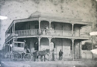 City of Ballarat Libraries
Photograph - Card Box Photographs, Lake View Hotel, Lake Wendouree circa 1890
... and Victoria Street.... the Lake and Victoria Street. Lake View Hotel J. Allen Building ...The Gill children are on the upstairs veranda. J. Allen's horse drawn omnibus, plied their trade between the Lake and Victoria Street.lake view hotel, j. allen, building, hotel, vehicle -
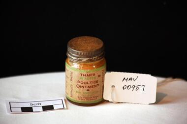 City of Moorabbin Historical Society (Operating the Box Cottage Museum)
Manufactured Glass, 'Thars' ointment, mid 20th C
... Chemical Co. / Pty. Ltd. / 74-76 Victoria Street / North Richmond... / OINTMENT / Thar Chemical Co. / Pty. Ltd. / 74-76 Victoria Street ...A poultice is a soft moist mass, often heated and medicated, that is spread on cloth over the skin to treat an aching, inflamed, or painful part of the body. It can be used on wounds such as cuts, inflammations like boils and to draw out splinters.A clear glass jar with a metal screw top containing 'Thar's' antiseptic poultice ointment.Front THAR'S / ANTISEPTIC / POULTICE / OINTMENT / Thar Chemical Co. / Pty. Ltd. / 74-76 Victoria Street / North Richmond / Left Side WAR-TIME PACK / FOR ......... Right Side DIRECTIONS ....... / Vertically sides Purifying, Soothing / Antiseptic, Healing pharmacy, medicines, thars ointment, thar chemical company, hospitals, nursing, containers, moorabbin, richmond, bentleigh, cheltenham, melbourne, poultices, medical poultices -
 Bendigo Historical Society Inc.
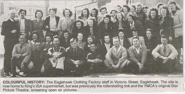
Newspaper - JENNY FOLEY COLLECTION: COLOURFUL HISTORY
... staff in Victoria Street, Eaglehawk. The site is now home...: the Eaglehawk Clothing Factory staff in Victoria Street, Eaglehawk ...Bendigo Advertiser "The way we were" from Wednesday, April 6, 2005. Colourful history: the Eaglehawk Clothing Factory staff in Victoria Street, Eaglehawk. The site is now home to King's IGA supermarket, but was previously the roller-skating rink and the YMCA's original Star Picture Theatre, screening open air pictures.newspaper, bendigo advertiser, the way we were