Showing 474 items
matching water well
-
 Eltham District Historical Society Inc
Photograph, Liz Pidgeon, Heritage Excursion; East of Eltham, 6 Sep 2014, 20 May 2017
Newsletter No. 218, September 2014 September Excursion - East of Eltham Walk In Newsletter No. 197, March 2011, there was a brief history of Crown Allotment 15 Section 5 Parish of Nillumbik (CA 15) a parcel of land of a quarter of a square mile extending from Eucalyptus Road to Reynolds Road at the eastern extremity of Eltham. From the 1940s it was known as Stokes orchard. In later years it has been subdivided for residential purposes but leaving significant areas as power line and water supply reserves and bushland reserves that are habitat for the threatened For our excursion on 6th September we intend to walk through CA 15 to a bushland reserve east of Reynolds Road. The walk will traverse the boundary between suburban Eltham and the non-urban areas to the south and east. This is a pleasant walk through residential areas and bushland. Along the way we will discuss the early and more recent history of CA 15 as well as local natural history and geology. This walk is about 3.5 km in length and will take 2 to 2.5 hours. It will start at 2pm at the corner of Eucalyptus Road, Pitt Street and Nyora Road.Born Digitaleltham east, eltham district historical society, heritage excursion, activities, nyora road, reynolds road, gum tree road reserve, diosma road, stokes orchard, eucalyptus road -
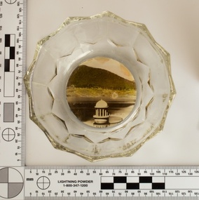 Melbourne Water
Souvenir confectionery bowl, 1930s-40s
Melbourne Water inherited many of its water assets, such as reservoirs from its predecessor the Melbourne Metropolitan Board of Works (MMBW). They have served the organisation well and have long been celebrated for both their natural beauty and engineering ingenuity. In the nineteenth century Victoria’s fundamental need for water infrastructure went beyond merely functional solutions and reflected the English ideal of the romance and beauty that was embodied in expanses of water. The MMBW further enhanced this notion by incorporating beauty and function in to the Classical and Italianate designs of its infrastructure such as pumping houses and reservoir outlet towers. The reservoir gardens and picnic areas were landscaped with ornamental stonework, exotic trees, decorative flower beds, fern glades pools and rose gardens. All features of the water supply system became widely celebrated as beauty spots that continue to be very popular to this day with tourists and locals alike. This souvenir is a product of that flourishing tourist trade. These water supply sites continue to enhance Melbourne’s charm and liveability and are now recognised as places of cultural and historic significance. This souvenir item has been curated by Melbourne Water as it represents an important historical aspect of the organisation by demonstrating the popularity of its water asset sites as recreational places and tourist attractions, and although these sites are functional parts of the water supply system, they were also designed to be enjoyed by the public both aesthetically and recreationally. Clear glass flower shaped 'depression ware' confectionery bowl, with photographic image of Maroondah Reservoir outlet tower on basemelbourne metropolitan board of works, mmbw, maroondah reservoir, melbourne water, scenic view, souvenir, glass bowl -
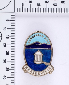 Melbourne Water
Souvenir lapel pin/brooch Maroondah Dam, 1960s/70s
Melbourne Water inherited many of its water assets, such as reservoirs from its predecessor the Melbourne Metropolitan Board of Works (MMBW). They have served the organisation well and have long been celebrated for both their natural beauty and engineering ingenuity. In the nineteenth century Victoria’s fundamental need for water infrastructure went beyond merely functional solutions and reflected the English ideal of the romance and beauty that was embodied in expanses of water. The MMBW further enhanced this notion by incorporating beauty and function in to the Classical and Italianate designs of its infrastructure such as pumping houses and reservoir outlet towers. The reservoir gardens and picnic areas were landscaped with ornamental stonework, exotic trees, decorative flower beds, fern glads pools and rose gardens. All features of the water supply system became widely celebrated as beauty spots that continue to be very popular to this day with tourists and locals alike. This souvenir is a product of that flourishing tourist trade. These water supply sites continue to enhance Melbourne’s charm and liveability and are now recognised as places of cultural and historic significance. This souvenir item has been curated by Melbourne Water as it represents an important historical aspect of the organisation by demonstrating the popularity of its water asset sites as recreational places and tourist attractions, and although these sites are functional parts of the water supply system, they were also designed to be enjoyed by the public both aesthetically and recreationally. Blue enamel and metal lapel pin/brooch depicting Maroondah Reservoir and outlet tower. Oval shaped with words 'Maroondah Dam' at the top and a ribbon banner containing 'Healesville' at the bottom. Maroondah Dam. Healesvillemelbourne metropolitan board of works, mmbw, maroondah reservoir, melbourne water, scenic view, souvenir, lapel pin, brooch -
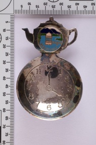 Melbourne Water
Souvenir tea caddy spoon "Tea Time", Early 1960s
Melbourne Water inherited many of its water assets, such as reservoirs from its predecessor the Melbourne Metropolitan Board of Works (MMBW). They have served the organisation well and have long been celebrated for both their natural beauty and engineering ingenuity. In the nineteenth century Victoria’s fundamental need for water infrastructure went beyond merely functional solutions and reflected the English ideal of the romance and beauty that was embodied in expanses of water. The MMBW further enhanced this notion by incorporating beauty and function in to the Classical and Italianate designs of its infrastructure such as pumping houses and reservoir outlet towers. The reservoir gardens and picnic areas were landscaped with ornamental stonework, exotic trees, decorative flower beds, fern glads pools and rose gardens. All features of the water supply system became widely celebrated as beauty spots that continue to be very popular to this day with tourists and locals alike. This souvenir is a product of that flourishing tourist trade. These water supply sites continue to enhance Melbourne’s charm and liveability and are now recognised as places of cultural and historic significance This souvenir item has been curated by Melbourne Water as it represents an important historical aspect of the organisation by demonstrating the popularity of its water asset sites as recreational places and tourist attractions, and although these sites are functional parts of the water supply system, they were also designed to be enjoyed by the public both aesthetically and recreationally. Tea caddy spoon with clock face engraved showing 4pm on round spoon, tea pot shaped handle with enamel scenic view badge saying 'Healesville' ( depicting Maroondah Reservoir outlet tower). Tea caddy spoon box labelled 'Fine Silverware by Stokes'Stokes and Sons Stokes & Sons logo (Star with S and boomerang) EG. No. 15733melbourne metropolitan board of works, mmbw, maroondah reservoir, melbourne water, scenic view, souvenir, tea caddy spoon -
 Port Melbourne Historical & Preservation Society
Book, Water works, Trust - Inwards Correspondence, 1890s
Originally a correspondence record for the Warracknabeal Waterworks, this book was recycled for use as a visitors' register for the Missions to Seamen building, during the years the Mission Arts Centre occupied it (1987 - 1990). Included are signatures of visitors during the Bicentenary celebrations, January 1988 as well as casual visitors and attendees at exhibitions, performances, concerts, community days, private parties, etc.Large bound volume, blue with tan leather binding, stamped in gold "Water Works, Trust - Inwards Correspondence", used as visitors' register for the Mission Arts Centre, Missions to Seamen building 1987-89missions to seamen, mission arts centre -
 Monbulk RSL Sub Branch
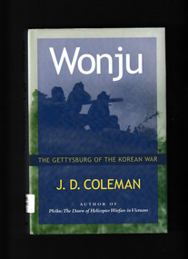
Book, Brassey's, Wonju : the Gettysburg of the Korean War, 2000
Just as the Battle of Gettysburg was the high-water mark of the Confederacy's bid for secession, the Chinese offensive launched at Wonju was the high point from which China's hopes for victory soon faded. This is the first book to show that after fifteen days of combat at Wonju, Chinese leaders realized that they could not win the war and could possibly lose it. On this not particularly well-known battlefield, UN forces led by brave U.S. and South Korean fighting men ensured South Korean independence. These battles reinvigorated the UN war effort, thanks in no small part to the leadership of the U.S. Eighth Army's new commander, Lt. Gen. Matthew Ridgway. J. D. Coleman's comparison between the pivotal battles of Wonju and Gettysburg is original and thought provoking.Index, bibliography, notes, ill, maps, p.301.non-fictionJust as the Battle of Gettysburg was the high-water mark of the Confederacy's bid for secession, the Chinese offensive launched at Wonju was the high point from which China's hopes for victory soon faded. This is the first book to show that after fifteen days of combat at Wonju, Chinese leaders realized that they could not win the war and could possibly lose it. On this not particularly well-known battlefield, UN forces led by brave U.S. and South Korean fighting men ensured South Korean independence. These battles reinvigorated the UN war effort, thanks in no small part to the leadership of the U.S. Eighth Army's new commander, Lt. Gen. Matthew Ridgway. J. D. Coleman's comparison between the pivotal battles of Wonju and Gettysburg is original and thought provoking.korean war 1950-1953 - history, korean war - battle of wonju -
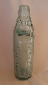 Donald History and Natural History Group operating the Donald Court House Museum
Aerated Water Bottle
Mr W. H. (Billy) Lewis manufactured soft drinks and cordials of many types in his factory in Woods street south, Donald. An energetic man, Mr. Lewis built up a big business, and supplied surrounding towns and districts as well as shops and customers in the Donald and Watchem areas. In the later stages of operation he was assisted by his son Alf, who died in May, 1952. Mr. W. H. Lewis died in June, 1924. The patronage accorded to the Lewis products enabled Mr Lewis to keep the factory in full production for many years.Aqua codd-neck glass bottle. Four round indents above two neck side crimps. W. H. LEWIS DONALD moulded lengthwise on front. LEMONADE moulded horizontally on back. "M" moulded on base. Glass marble and rubber washer inside. Some inner stain. -
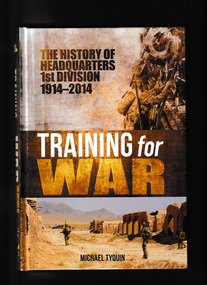 Monbulk RSL Sub Branch
Book, Michael Tyquin, Training for war : the history of headquarters 1st Division 1914-2014, 2017
Training for War encapsulates one hundred years of the history of Headquarters 1st Division and the Deployable Joint Force Headquarters. During that time the Headquarters has commanded subordinate formations and units; soldiers; and assets. They all have a place in this story as do many distinguished Australians who have had a close association with the Division, either commanding it or holding senior positions there. This study looks at the organisation's high water mark in World War One as well as quieter times between the world wars, before the tempo picks up again in the period closer to our own time. As with any military formation it cannot be studied in isolation from politics and policy and so reference is made to wider events in the Australian political and Defence environment. For those wanting new insights into one of the Australian Army's most historic divisions this work should satisfy their needs.Index, bib, ill, maps, p.254.non-fictionTraining for War encapsulates one hundred years of the history of Headquarters 1st Division and the Deployable Joint Force Headquarters. During that time the Headquarters has commanded subordinate formations and units; soldiers; and assets. They all have a place in this story as do many distinguished Australians who have had a close association with the Division, either commanding it or holding senior positions there. This study looks at the organisation's high water mark in World War One as well as quieter times between the world wars, before the tempo picks up again in the period closer to our own time. As with any military formation it cannot be studied in isolation from politics and policy and so reference is made to wider events in the Australian political and Defence environment. For those wanting new insights into one of the Australian Army's most historic divisions this work should satisfy their needs.australian army - organisation, australian army - 1st division -
 Eltham District Historical Society Inc
Film - Video (VHS), Diamond Creek Fire Brigade, c.1955-1987
Combination of three movie films. Movie One (1950s): 00:00 – 13:14 Black and white footage of Diamond Creek firemen practising in Diamond Street in the 1950s for forthcoming demonstrations of abilities. Mentions of Gordon Brandy and Joe Hislop Running out hoses from old hose reels along Diamond Street, Diamond Creek Displays from various brigades running out and connecting hoses. Also scenes from the 1950s of Diamond Creek Fire Brigade competing in various locations around Victoria and Tasmania. Mentions of Brigade members Dave Kidd, Bruce Hackett, Ron Kirkbride, Jack Marks, Graham Upton who are prominent in these events. Members of Kyneton Fire Brigade also present. Members competing in running out hose reels, connecting hoses togethers and to hydrants then climbing towers to direct water from hose or at a target hanging above the road. Diamond Creek members identified wearing a diamond on their chest and back. Includes scenes of Scottish pipe bands at the events and significant crowds of spectators. Footage of Mel Stone and Beryl Marks, Stan Redpath and Ron Kirkbride, then Ron Kirkbride and Eric Holt viewing flower displays. Film changes to colour at Diamond Creek oval for practice with fire engine entering oval. Members depicted include Bill May, Jack Sinclair, Jim Cox, Bob Beale, Dave Kidd, Bruce Hackett and Captain Clarrie Stone. Reverts to black and white in the 1950s where the Brigade joins forces with the Diamond Valley Community Hospital for a Gala Day on the Diamond Creek Oval. Changes to colour again, possibly same event and scenes of children on bikes and scooters or with prams and carts racing around the oval. Mention of young lad Brian Laurie who has his own fire truck. Dart throwing, pony rides. Scenes with Dr Don Cordner, Gus Lyons, Vic Cohn (?) and spinning wheel and Diamond Creek School children entertain a large crowd with Maypole dancing. Movie Two (1950s): 13:25 – 19:00 This black and white film was taken by a TV film crew in the 1950s depicts a typical call out for the Diamond Creek Fire Brigade. In this case the careless action of a member of the public throwing a lighted match from a car, which can cause extensive damage. Footage features the Shire of Eltham War Memorial tower at Kangaroo Ground before it was modified with a fire spotter’s cabin. Discusses fire spotting operations from the tower. Shows a fire spotter walking around the top of the tower. A fire is detected, and the information is relayed to the nearest fire station, in this case, Diamond Creek. The telephone call is received, and the alarm sounded. Captain Clarrie Stone and firemen May and Shaw leave their workplaces and prepare for action. Scenes of running across the Main Hurstbridge road showing the shops (Shell service station and Chemist prominent). Scenes entering the fire station which has a pictorial warning covering the entire door “Only you can prevent forest fires – If you’re careless – we’re homeless!” Eric Holt pinpoints the location of the fire while Captain Clarrie Stone and Fireman Shaw take note. The advance vehicle (an FE Holden ute, rego GTE-696) leaves to assess the extent of the fire. Having assessed the fire, Fireman Shaw communicates with base showing radio with call sign VL3JZ. Eric Holt takes the call. In the meantime, Captain Clarrie Stone and Fireman Shaw undertake some limited action to address the fire. Firemen Bill May, Jim Bates and Hugh Bar (?) man the tanker. A photo portrait of Queen Elizabeth is visible hanging on the wall. They are later joined by Firemen Jim Cox, Eric DeBuse (?) and Jack Marks. The tanker is seen departing the station and diverging off before the bridge. Captain Clarrie Stone and Fireman Shaw are seen pumping water on the flames with hand pumps when the tanker arrives. The hose is unreeled, and water turned on the flames. Jack Sinclair joins the action. Jim Cox directs water to the high stuff. The fire put out, Jack Marks and Eric DeBuse wind in the hoses and the team head back to town. It’s peaceful again at the memorial tower. Movie Three (1969-1987): 19:14 – 34:34 Colour film “Fired with Dedication”, Country Fire Authority Victoria, produced by I.L. Wadeson, Commentary by A.M. Hem. Credits with CFA Victoria emblem and then placed over a view of an old-style ladder engine. Opens with the scene of a fire engine outside the Diamond Creek Fire Station then various trophies reflecting the competition success of the brigade in various track and disciplined events. Two trophies shown of particular pride to the brigade were for first place in the Torchlight Procession at the State Championships in Mildura in 1986 and also at Swan Hill in 1981. Still photo scenes of ex Captain Clarrie Stone, Brigade Captain for 21 years; ex Captain Jack Marks, 10 years; ex Captain Ian Douglas, 10 years. Cuts to scene of radio control room, January 1969, and news of a fire on the northern side of the township of Diamond Creek. With scenes of flames in bush, the narration explains that until the early 1960s the area was an orchard district which protected the town against the savagery of bushfires. But due to competition from other areas more suitable for orcharding and easier transport to Melbourne the district could no longer remain competitive, and orchards were replaced by grassed areas, which together with the bush areas were a feeding ground for fire. On 8th January 1969, high temperatures and strong north winds, were, with the carelessness of some individual all that was necessary to produce the worst fire the district had seen. Cuts to scene of blackened fields and cattle - Hundreds of hectares of grass land were blackened, and cattle had to be transported to other areas for agistment. Scene of destroyed buildings in the township – 13 houses and the public hall in the town were destroyed as was the theatre equipment which was owned by the fire brigade. The Church of England Hall and bell tower were badly damaged. The whole town could have been burnt out but for the determination, skill, and courage of the Diamond Creek Fire Brigade. Scenes of all that was left of the home on the hill on the west side of the Church of England. Also, the remains of the old Pisy (?) home on the top of the same hill near Lambert Street, and the ruined Crocker home. Cuts to a scene in the mid-1970s to mid-1980s of a house fire in Haley Street attended by the Diamond Creek Fire Brigade. Although the house was severely damaged, it was saved. Mentions that whilst assistance is appreciated, in some circumstances, those doing so are not properly dressed for fighting fires. Breathing apparatus is a must in structure fire attack. Next scene (either on Mangarook or Coventry oval) showing off four Diamond Creek Fire Brigade efficient and very expensive firefighting units. Features a forward control vehicle Toyota 4WD used for conveying task force personnel to the required areas; a Hino Model 3.2 tanker, diesel powered and carries 3,000 litres of water and has a 16 HP petrol driven pump which delivers 900 litres of water per minute; an International tanker (registration TCM-418) which carries 3,000 litres of water with pumping capacity of 600 litres per minute. The Ford diesel powered pumper (registration MXE-754) is a well-equipped vehicle with a water capacity of 1,000 litres and capable of pumping 1,900 litres of water per minute from the main pump, has many lockers which hose equipment such as breathing apparatus and various types of hose nozzles and foam making equipment. The vehicle carries 360m of 64mm diameter hose which can be laid out from the rear lockers and a portable lighting plant, an Oxy Viva resuscitator to revive smoke inhalation victims and forcible entry tools to gain access to structure fires. Views of the main pump and control panel on the vehicle. As well as the main pump, the vehicle is equipped with an auxiliary pump which allows the facility to pump whilst moving. Fire fighters must undergo constant training and hone their skills, Scenes of a training exercise using the pumper to pump from static water. First, the short lengths of suction hose are coupled, a strainer fitted to ensure debris does not foul the pump. Gauges must be constantly monitored to ensure manageable water pressures are maintained. Pressures are normally controlled to allow two fire fighters to work at each nozzle outlet. Two nozzles are tested, one adjustable jet fog type which is used on flammable gasses or within a structure fire to absorb heat. A straight jet nozzle to project water long distances to protect exposed surfaces close to a fire radiated heat. The pumper is quite a versatile vehicle in handling structure fires, but it also carries specialist equipment needed in containing hazardous chemical incidents. Cuts to scene of parade – the Diamond Creek Fire Brigade has with other neighbouring brigades participated in most town fairs and earns the respect of the watching public. It can be seen why this brigade has been so successful at disciplined contests. Views of Plenty Fire Brigade Road Rescue unit which is equipped with the “Jaws of Life” Scenes of athletic competitions – many neighbouring brigades indulge in friendly but keen competition at the Diamond Creek Town Fair. The young are also encouraged to participate in all aspects of Junior Fire Brigade activities and become tomorrow’s generation of volunteer fire fighters. Scene of the 1986 Diamond Creek Town Fair which was the last time veteran Captain Clarrie Stone BEM marched with the brigade. Clarrie was awarded the British Empire Medal for his service to the Country Fire Authority. Also, scenes of vehicles in the parade. Cuts to scene of brigade members in drill formation for inspection by Acting Chief Harry Rothsay (?) on the occasion of the opening of the new fire station extensions on August 29, 1987. Rudy Libel (?) Captain at the time. Scenes of crowds including many dignitaries of neighbouring brigades present including Lieutenant Gordon Grandy (who came down from Queensland for the occasion) and ex-Secretary David Kidd and wife Betty, also ex Captain Clarrie Stone and Mrs Nel Stone, a life member of the Ladies Auxiliary, the Reverend Jock Ryan, son of J.L Ryan, founder of the Diamond Creek Fire Brigade, Foundation Captain of the fire brigade, Keith Bradbury and Mrs Bradbury. Pauline Dick accepts a community service award for services to the CFA. Recognising over 47 and a half years of service, a presentation is made by Mr Neil Marshall, Acting Chairman of the CFA to ex Captain Clarrie Stone with response by Clarrie. Other members of the official party include Cr. Martin Wright, Shire President Wayne Phillips and local Member of Parliament, Mrs Pauline Toner. Ex foreman John Bennett is presented with a life member’s awards by Captain Rudy Libel. The camera also catches Gwen Cox, Jean Ryan and Bessie Layton (?) Provides historic footage of people, places and equipment and a record of the worst fires expoerienced in Diamond Creek in 1969BASF Standard Quality SQ E-180 VHS dubbing (poor quality) of three films Converted to MP4 file format 0:34:38, 1.85GBOn label: "Donation - August 2000 Diamond Creek Unit Old films made up from Fire Brigade shows at competitions - also Kangaroo Ground Tower being used"video recording, diamond creek fire brigade, 1986 diamond creek town fair, a.m. hem, acting chief harry rothsay, athletic competitions, beryl marks, bessie layton, betty kidd, bill may, bob beale, brian laurie, bruce hackett, captain clarrie stone, chemist, church of england hall, clarrie stone, clarrie stone bem, country fire authority victoria, coventry oval, cr. martin wright, crocker home, dart throwing, dave kidd, david kidd, diamond creek, diamond creek fire station, diamond creek oval, diamond creek school, diamond creek town fair, diamond street, diamond valley community hospital, dr don cordner, eric debuse, eric holt, fe holden ute, fire damage – buildings, fire spotter, fire spotter’s cabin, fire station extension, fired with dedication (film), firefighting units, fireman shaw, firemen jim cox, ford pumper, foundation captain, gala day, gordon brandy, gordon grandy, graham upton, gus lyons, gwen cox, haley street, hino model 3.2 tanker, house fire, i.l. wadeson, ian douglas, international tanker, j.l ryan, jack marks, jack sinclair, january 1969, jaws of life, jean ryan, jim bates and hugh bar, jim cox, joe hislop, john bennett, kangaroo ground, kangaroo ground tower, keith bradbury, kyneton fire brigade, lambert street, main hurstbridge road, mangarook oval, maypole dancing, mel stone, mildura 1986, mrs bradbury, mxe754 vic registration, neil marshall, nel stone, orchard district, oxy viva resuscitator, pauline dick, pauline toner mp, pisy home, plenty fire brigade road rescue unit, pony rides, radio control room, reverend jock ryan, ron kirkbride, rudy libel, shell service station, shire of eltham war memorial, shire president wayne phillips, spinning wheel, stan redpath, state championships, swan hill 1981, tcm418 vic registration, torchlight procession, toyota 4wd, trophies, vic cohn, victorian bushfires - 1969, vl3jz -
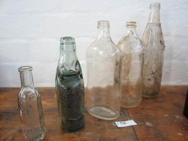 Parks Victoria - Wilsons Promontory Lightstation
Bottles
The catalogue includes twenty-one diverse types of bottles ranging from beer, soft drink and chutney bottles to bottles designed to hold perfume, medicines and poisons. They appear to range in date from the nineteenth to c.mid-twentieth centuries and represent various types of mass-produced consumer goods that were commonly available at the time. The five different types of bottles included in 0156.5 are made of clear glass with tapered necks and narrow openings to facilitate pouring. One can be positively identified as an imported mineral soda water/soft drink bottle because of the marble stopper in the neck and thickness of the glass. The globe-stopper bottle, also known as a ‘Codd’ bottle, was invented by English engineer, Hiram Codd in 1873 for holding gaseous soft drinks. The thick glass could withstand the pressure of the contents as well as repeated bottling by manufacturers. The bottles were probably used by former lightkeeper households. and tapered, narrow necks. The older ‘porter’ has a slightly bulbous neck. The bottles were probably used by former lightkeeper residents. Five glass bottles. Four are clear glass and one has coloured to green. -
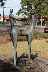 Darebin Art Collection
Sculpture - Velislav (Will) Georgiev, Zabelski Han, & Victoria Roxburgh, Velislav (Will) Georgiev, Zabelski Han, & Victoria Roxburgh, Well Place Preston, 2004
Half horse, half human bronze sculpture, the work has a circular formation of rocks as a base and incorporates a water feature. Water slowly cascades from a bowl held by the human and offered to the horse. The work has a circular formation of rocks as a base.Half horse, half human bronze sculpture. The work incorporates a water feature, and water slowly cascades from a bowl held by the human and offered to the horse. The work has a circular formation of rocks as a base. The “bowl” part of the base for this work was relined with concrete pavers in 2004 in an attempt to minimise maintenance. -
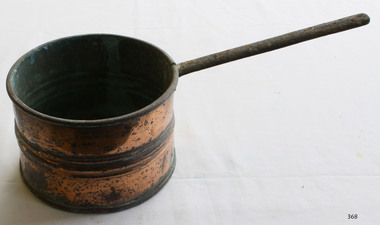 Flagstaff Hill Maritime Museum and Village
Domestic object - Saucepan
It is no secret that copper is currently experiencing a huge upsurge in popularity. This is mainly thanks to its beautiful colour featuring heavily in the ranges of countless homeware retailers. There is, however, far more to this lustrous metal than just its appearance. For example, it has a greater level of thermal conductivity than any other metal (except silver); roughly 60% higher than aluminium and 3000% higher than stainless steel. This means copper is capable of heating up very quickly when compared to other metals. Perhaps a less commonly known property of copper is it being inherently antimicrobial. A wide range of harmful microbes are unable to survive for more than a couple of hours when in contact with a surface made of copper or one of its alloys (brass and bronze). This has led to it often being used for frequently touched surfaces such as door knobs, push plates and taps. A seemingly perfect material for cooking, it is therefore no surprise that it has been used in kitchens for millennia. But exactly when did we learn to utilise copper and its valuable assets? Origins It is hard to pin down an exact date when copper cookware was first introduced. Pieces discovered in regions of the middle east were dated as far back as 9000BC, suggesting cooking with copper began during the Neolithic period (≈10000-2000BC). As civilisations became increasingly capable in metallurgical techniques, metals such as copper became more widely used. It would have been around this time that copper replaced stone as the material used for making tools and cooking vessels. The use of copper is also well documented in Ancient Egypt. Not only was it used to produce water and oil containers, but it was also used to in medical practices. The antimicrobial nature of copper was exploited long before the concept of microorganisms was fully understood. The Smith Papyrus, a medical text written between 2600 and 2200BC records the use of copper in sterilising wounds and drinking water. Tin Lining Although copper is essential to many processes within the human body, it can become toxic if consumed in excess. It was this knowledge that gave rise to lining cookware with tin, a technique used for hundreds of years to prevent copper leaching in to food. These tin linings would eventually wear out and during the 18th and 19th century, it was common for people to send pans away to be re-tinned. This practice is becoming increasingly rare, as are the craftsmen who perform it. Despite this, there are still manufactures producing tin-lined copper cookware who also offer a re-lining service. Perhaps the best known of these is Mauviel, a French manufacturer who have been making this type of cookware since 1830. Tin has now largely been replaced by stainless steel as an interior cooking surface. Not only is it more cost effective, but the high grade of stainless steel used in premium cookware (typically 18/10) is highly resistant to corrosion and more durable than tin.Copper saucepans are still used in many kitchens.Small copper saucepan with long handle and three ridges around the circumference. Extensive corrosion.None.flagstaff hill, warrnambool, shipwrecked-coast, flagstaff-hill, flagstaff-hill-maritime-museum, maritime-museum, shipwreck-coast, flagstaff-hill-maritime-village, copper, saucepans, kitchen equipment -
 Wodonga & District Historical Society Inc
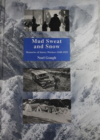
Book - Mud Sweat and Snow: Memories of Snowy Workers 1949-1959, Noel Gough, 1994
This book tells the human story of the first decade of building the great Snowy Mountains Hydro-Electric Scheme, with adventures and anecdotes told by the workers themselves, and illustrated with unusual photographs. Appendices give further information about the project and list the workers named in Snowy records. The author began his 10 years with the Electrical and Mechanical Division at the age of 20. The construction of the Snowy Mountains Hydro-electric Scheme is a well-documented part of our nation’s history and a leading example of Australian innovation and ingenuity. As far back as the 1880s, Australians had been considering diverting water from some of Australia’s best-known rivers – the Murray, Murrumbidgee, Snowy and Tumut – to drought-proof parts of NSW and Victoria. It was not until 1944 that Commonwealth and State governments formed a committee to examine the development of water resources in the Snowy Mountains area. As a result of their work, on 7 July 1949, the Commonwealth Parliament passed legislation to establish a Statutory Authority and start construction of the Snowy Scheme. NSW. Construction was completed in 1974 at a total cost of $820 million. On completion, the Scheme consisted of seven power stations, 16 major dams, 80 kilometres of aqueducts and 145 kilometres of interconnected tunnels.non-fictionThis book tells the human story of the first decade of building the great Snowy Mountains Hydro-Electric Scheme, with adventures and anecdotes told by the workers themselves, and illustrated with unusual photographs. Appendices give further information about the project and list the workers named in Snowy records. The author began his 10 years with the Electrical and Mechanical Division at the age of 20. The construction of the Snowy Mountains Hydro-electric Scheme is a well-documented part of our nation’s history and a leading example of Australian innovation and ingenuity. As far back as the 1880s, Australians had been considering diverting water from some of Australia’s best-known rivers – the Murray, Murrumbidgee, Snowy and Tumut – to drought-proof parts of NSW and Victoria. It was not until 1944 that Commonwealth and State governments formed a committee to examine the development of water resources in the Snowy Mountains area. As a result of their work, on 7 July 1949, the Commonwealth Parliament passed legislation to establish a Statutory Authority and start construction of the Snowy Scheme. NSW. Construction was completed in 1974 at a total cost of $820 million. On completion, the Scheme consisted of seven power stations, 16 major dams, 80 kilometres of aqueducts and 145 kilometres of interconnected tunnels.snowy mountains hydro-electric scheme, hydroelectric power plants, snowy mountains -
 Melbourne Legacy
Slide, Operation Float 1958, 1958
Operation Float was an event run by Melbourne Legacy to take Junior legatees on an outing. It could have been to naval boats such as HMAS Cerberus or to a Yacht club. It gave the junior legatees the opportunity to see a naval boat in action, spend time on the water or try sailing. More images from the same outing are catalogued at 02479 and 02480. The slides have been photographed to make digital images and moved to archive quality sleeves. In many cases the original images were not well focussed and the digital image the best available.A record of an event for junior legatees in the 1950s.Colour slide x 10 of operation float in 1958 in red Hanimount slide mounts.operation float, boats, junior legatee outing -
 Melbourne Legacy
Slide, Operation Float 1958, 1958
Operation Float was an event run by Melbourne Legacy to take Junior legatees on an outing. It could have been to naval boats such as HMAS Cerberus or to a Yacht club. It gave the junior legatees the opportunity to see a naval boat in action, spend time on the water or try sailing. More images from the same outing are catalogued at 02478 and 02480. The slides have been photographed to make digital images and moved to archive quality sleeves. In many cases the original images were not well focussed and the digital image the best available.A record of an event for junior legatees in the 1950s.Colour slide x 8 of operation float in 1958 in red Hanimount slide mounts.operation float, boats, junior legatee outing -
 Melbourne Legacy
Slide, Operation Float 1958, 1958
Operation Float was an event run by Melbourne Legacy to take Junior legatees on an outing. It could have been to naval boats such as HMAS Cerberus or to a Yacht club. It gave the junior legatees the opportunity to see a naval boat in action, spend time on the water or try sailing. More images from the same outing are catalogued at 02477 and 02478. There is one image with the children meeting a goat that is at the harbour. The slides have been photographed to make digital images and moved to archive quality sleeves. In many cases the original images were not well focussed and the digital image the best available.A record of an event for junior legatees in the 1950s.Colour slide x 5 of operation float in 1958 in red Hanimount slide mounts.operation float, boats, junior legatee outing -
 Melbourne Legacy
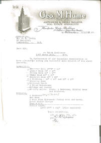
Letter, re Brick Residence 1267 Burke Road, Kew, 1942
Detailed measurements of the rooms, but the plan of the land noted as being enclosed is not included. The details had been requested in a previous telephone conversation between the parties, indicating early interest in purchasing the property which ultimately became Holmbush. Despite being from a real estate agent there is little in the way of a sales pitch.As well as indicating the extent of the rooms, it also notes that the property had a coke hot water system, which would have been typical of the 1940s, as would the elaborate letterhead.Typewritten undated letter on letterhead of Geo.M.Hume Pty Ltd., black on white, addressed to Mr. D.N. CraigSignature illegible.holmbush initial negotiations, properties, holmbush -
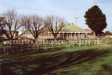
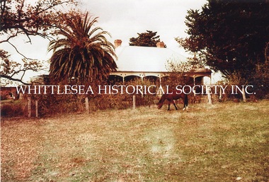 Whittlesea Historical Society Inc.
Photograph, Carome, Mernda, c. 1960
3 photographs showing Carome at Mernda dated mid 1960's. CAROME In 1840 Arthur Sergeantson purchased Section 19, Parish of Morang, a total of 842 acres. He named the property `Sergeantson Hall’ but the portion between the Plenty Road and Plenty River soon became known as Carome, the name of a flour mill he established in 1841. In 1843 Sergeantson leased the mill to a miller named Anderson, who operated it until 1850. Anderson was followed by Robert Charles. The present dwelling date back to at least 1850, and possibly earlier. In 1857 Sergeantson’s remaining 411 acres and Carome Mill were purchased by Abraham Willis and William Hardesty, who refurbished and upgraded the mill at the enormous cost of 1,200 Pounds. In 1868 the Mill was destroyed by fire. Willis continued farming at Carome until 1899 when he leased the farm to his son Robert and retired to Carlton. Little of the Mill remains. It was set just downstream from the deep rocky waterhole which formed a natural dam. Local folklore has it that this waterhole was used for water games by the Aborigines. Europeans certainly swim there now, and locals refer to this area as Power's hole, named after the previous owners the Power family. Such a prominent waterhole is likely to have been well known to the Aborigines. (Reference: City of Whittlesea Heritage Study) 3 colour photographs.mernda, carome mernda, bluestone, power family, willis family, abraham willis, isabella willis, carome mill, powers hole -
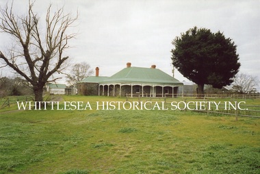 Whittlesea Historical Society Inc.
Photograph, Carome, Mernda, 2006
5 photographs showing Carome homestead and property at Mernda dated 2006. 1. Carome homestead. 2. Carome, looking southward down old rail line. 3. Carome homestead. 4. Dairy/feed sheds at Carome. 5. Carome property. CAROME In 1840 Arthur Sergeantson purchased Section 19, Parish of Morang, a total of 842 acres. He named the property `Sergeantson Hall’ but the portion between the Plenty Road and Plenty River soon became known as Carome, the name of a flour mill he established in 1841. In 1843 Sergeantson leased the mill to a miller named Anderson, who operated it until 1850. Anderson was followed by Robert Charles. The present dwelling date back to at least 1850, and possibly earlier. In 1857 Sergeantson’s remaining 411 acres and Carome Mill were purchased by Abraham Willis and William Hardesty, who refurbished and upgraded the mill at the enormous cost of 1,200 Pounds. In 1868 the Mill was destroyed by fire. Willis continued farming at Carome until 1899 when he leased the farm to his son Robert and retired to Carlton. Little of the Mill remains. It was set just downstream from the deep rocky waterhole which formed a natural dam. Local folklore has it that this waterhole was used for water games by the Aborigines. Europeans certainly swim there now, and locals refer to this area as Power's hole, named after the previous owners the Power family. Such a prominent waterhole is likely to have been well known to the Aborigines. (Reference: City of Whittlesea Heritage Study) 5 colour photographs.Printed on Kodak Royal Digital Papermernda, carome mernda, bluestone, power family, willis family, abraham willis, isabella willis, carome mill, powers hole, william hardesty, arthur sergeantson -
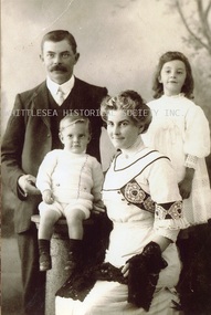 Whittlesea Historical Society Inc.
Photograph - Copy, Alfred, Lucy, Florence and Charles Arnold, c.1910
A photograph of Alfred Arnold his wife Lucy (nee Willis) and their children Florence and Charles. Lucy is the daughter of Abraham and Isabella Willis of Carome in Mernda. CAROME In 1840 Arthur Sergeantson purchased Section 19, Parish of Morang, a total of 842 acres. He named the property `Sergeantson Hall’ but the portion between the Plenty Road and Plenty River soon became known as Carome, the name of a flour mill he established in 1841. In 1843 Sergeantson leased the mill to a miller named Anderson, who operated it until 1850. Anderson was followed by Robert Charles. The present dwelling date back to at least 1850, and possibly earlier. In 1857 Sergeantson’s remaining 411 acres and Carome Mill were purchased by Abraham Willis and William Hardesty, who refurbished and upgraded the mill at the enormous cost of 1,200 Pounds. In 1868 the Mill was destroyed by fire. Willis continued farming at Carome until 1899 when he leased the farm to his son Robert and retired to Carlton. Little of the Mill remains. It was set just downstream from the deep rocky waterhole which formed a natural dam. Local folklore has it that this waterhole was used for water games by the Aborigines. Europeans certainly swim there now, and locals refer to this area as Power's hole, named after the previous owners the Power family. Such a prominent waterhole is likely to have been well known to the Aborigines. (Reference: City of Whittlesea Heritage Study) Copy of black and white photograph.Printed on Kodak Professional Endura Papermernda, carome mernda, bluestone, power family, willis family, abraham willis, isabella willis, carome mill, powers hole, william hardesty, arthur sergeantson, alfred arnold, lucy willis, lucy arnold, florence arnold, charles arnold -
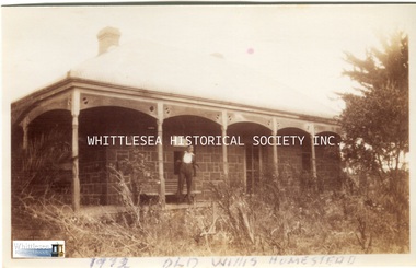
 Whittlesea Historical Society Inc.
Photograph, Carome Homestead, Mernda, 1972
A photograph showing Carome homestead in Mernda dated 1972. CAROME In 1840 Arthur Sergeantson purchased Section 19, Parish of Morang, a total of 842 acres. He named the property `Sergeantson Hall’ but the portion between the Plenty Road and Plenty River soon became known as Carome, the name of a flour mill he established in 1841. In 1843 Sergeantson leased the mill to a miller named Anderson, who operated it until 1850. Anderson was followed by Robert Charles. The present dwelling date back to at least 1850, and possibly earlier. In 1857 Sergeantson’s remaining 411 acres and Carome Mill were purchased by Abraham Willis and William Hardesty, who refurbished and upgraded the mill at the enormous cost of 1,200 Pounds. In 1868 the Mill was destroyed by fire. Willis continued farming at Carome until 1899 when he leased the farm to his son Robert and retired to Carlton. Little of the Mill remains. It was set just downstream from the deep rocky waterhole which formed a natural dam. Local folklore has it that this waterhole was used for water games by the Aborigines. Europeans certainly swim there now, and locals refer to this area as Power's hole, named after the previous owners the Power family. Such a prominent waterhole is likely to have been well known to the Aborigines. (Reference: City of Whittlesea Heritage Study) Colour photograph.Printed on Kodak Professional Endura Paper.mernda, carome mernda, bluestone, power family, willis family, abraham willis, isabella willis, carome mill, powers hole, william hardesty, arthur sergeantson -
 Whittlesea Historical Society Inc.
Photograph - Copy, Carome Homestead, Mernda, 1932
A photograph of a man in front of Carome Homestead, 1932. CAROME In 1840 Arthur Sergeantson purchased Section 19, Parish of Morang, a total of 842 acres. He named the property `Sergeantson Hall’ but the portion between the Plenty Road and Plenty River soon became known as Carome, the name of a flour mill he established in 1841. In 1843 Sergeantson leased the mill to a miller named Anderson, who operated it until 1850. Anderson was followed by Robert Charles. The present dwelling date back to at least 1850, and possibly earlier. In 1857 Sergeantson’s remaining 411 acres and Carome Mill were purchased by Abraham Willis and William Hardesty, who refurbished and upgraded the mill at the enormous cost of 1,200 Pounds. In 1868 the Mill was destroyed by fire. Willis continued farming at Carome until 1899 when he leased the farm to his son Robert and retired to Carlton. Little of the Mill remains. It was set just downstream from the deep rocky waterhole which formed a natural dam. Local folklore has it that this waterhole was used for water games by the Aborigines. Europeans certainly swim there now, and locals refer to this area as Power's hole, named after the previous owners the Power family. Such a prominent waterhole is likely to have been well known to the Aborigines. (Reference: City of Whittlesea Heritage Study) Copy of a black and white photograph.Handwritten on the back: Carome Mernda 1932mernda, carome mernda, bluestone, power family, willis family, abraham willis, isabella willis, carome mill, powers hole, william hardesty, arthur sergeantson -
 Phillip Island Conservation Society Inc.
Work on paper - Photocopy of newspaper cutting, "PENGU/ CHOK/ IN/ OIL" (meant to be : "Penguins choke in oil"
With the establishment of the large heavy industrial zone at Hastings in the late 1960s, which included the BP oil refinery using the Port of Hastings at the north-western arm of Western Port, a number of environmental problems predicted by both scientists and conservationists arose. The main shipping channel on the western arm of Western Port was dredged, causing suspended particles affecting seagrass beds. With inadequate regulation around discharge of bilge water within the bay, and oil spillage, oil pollution affecting both seabirds and coastal areas was not uncommon. This report of 40 penguins actually known to have been killed by an oil spill event was typical of reports at the time. The 2 men quoted – Vernon Johnson and Ken Pound – were well known conservationists. Vernon and his wife Nora owned the Kingston Gardens picnic and zoo business where they cared for many injured wildlife. Ken was a Phillip Island counsellor for a few years, and instrumental in the establishment of the Phillip Island conservation Society. He also contributed various documents and newspaper cuttings to this archive.This article is significant for being a record of an exact number of penguins found dead from oil spill pollution in Western Port. Also as a record of conservationists in the early years of community and environment movements both locally and in Australia. The article further gives evidence of linking tourism with wildlife.Photocopy of newspaper cutting. Black print with very dark black and white photo of Fairy (Little) Penguin. Poor reproduction due to older photocopy machine.(indecipherable) - late/1960s.little penguins, fairy penguins, eudyptula minor, penguin behaviour, phillip island tourist attractions, phillip island conservation society, oil spills, bp refinery hastings, port of hastings, western port, marine pollution, oil tankers, vernon johnson, ken pound, phillip island promotion association -
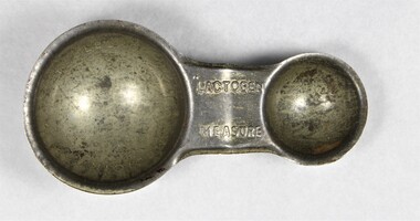 Wodonga & District Historical Society Inc
Domestic object - Haeusler Collection Lactogen baby formula measuring spoon c.1920s
The Wodonga Historical Society Haeusler Collection provides invaluable insight into life in late nineteenth and early twentieth century north east Victoria. The collection comprises manuscripts, personal artefacts used by the Haeusler family on their farm in Wodonga, and a set of glass negatives which offer a unique visual snapshot of the domestic and social lives of the Haeusler family and local Wodonga community. The Haeusler family migrated from Prussia (Germany) to South Australia in the 1840s and 1850s, before purchasing 100 acres of Crown Land made available under the Victorian Lands Act 1862 (also known as ‘Duffy’s Land Act’) in 1866 in what is now Wodonga West. The Haeusler family were one of several German families to migrate from South Australia to Wodonga in the 1860s. This item is a Nestlé Lactogen baby formula measuring scoop used in the preparation of formula for bottle feeding. It was used by Ilma Margaret Ernestine Haeusler (née Tasker, b.1900 in Tallangatta) to feed her son Alfred who was born in 1922. Ilma died in childbirth in 1928. This measuring spoon is one of several objects in the Haeusler Collection concerning early childhood that provide insight into family and home life in early twentieth century Wodonga. The first fully artificial infant milk formula, Farine Lactee, was developed in the 1860s. Companies continued to attempt to develop synthetic formulas which nutritionally replicated human breast milk in the decades that followed. Nestlé began producing Lactogen in 1921. It was marketed to women as a nutritionally superior substitute for breast milk, and as a nutritional supplement for breast feeding mothers. From the 1920s, when the Haeusler Collection measure was produced and used, Nestlé employed nurses in major Australian cities to promote Lactogen and its supposed health benefits to new mothers. They also used print advertisements to offer free product samples and instruction booklets advising on pregnancy and infant care for the same purpose. Nestlé was formed in 1905 by the merger of the Anglo-Swiss Milk Company, established in 1866 by brothers George and Charles Page, and Farine Lactée Henri Nestlé, founded in 1866 by Henri Nestlé. The company grew significantly during the First World War and again following the Second World War, expanding its offerings beyond its early condensed milk and infant formula products. In the twenty-first century, Nestlé has faced criticism and boycotts over its decision to market baby formula as an alternative to breastfeeding in developing countries. The adoption of bottle feeding in countries without access to clean water and sanitation infrastructure has contributed to high infant mortality rates. This item has well documented provenance and a known owner. It forms part of a significant and representative historical collection which reflects the local history of Wodonga. It contributes to our understanding of domestic and family life in early twentieth century Wodonga, as well as providing interpretative capacity for themes including local history, social history, and women’s history.Silver toned alloy measuring spoon for Lactogen infant formula, produced by food and drink manufacturing company Nestlé. Embossed with the Lactogen brand name, and teaspoon and tablespoon measurements. "LACTOGEN MEASURE" on central handle/"TABLESPOON" on large inner scoop/"TEASPOON" on small inner scoopchildren, babies, household, domestic, motherhood, family, kitchen -
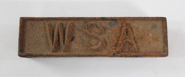 Wodonga & District Historical Society Inc
Functional object - Wodonga Sewerage Authority Identification Tag
The Wodonga Sewerage Authority identification tag is part of the collection of objects donated to the Wodonga Historical Society by the North East Region Water Authority in 2001. In 1983 the Wodonga Waterworks Trust and the Wodonga Sewerage Authority became part of the Wodonga Council. And by 1989 a filtration plant at Huon Hill was completed, which provided filtered water of improved quality to Wodonga, in accordance with the World Health Organisation’s guidelines. In 1994 the Kiewa Murray Region Water Authority took over the Wodonga Council’s water and wastewater operations, and then in 1999 the Kiewa Murray Region Water Authority combined with the Ovens Region Water Authority and became the North East Region Water Authority or NERWA. NERWA then became known as North East Water. The identification tag has local significance due to its use by the Wodonga Sewerage Authority, as well as historic significance as rare example of the equipment used in water management in Wodonga.Rectangular corroded cast iron identification tag with the raised letters '"WSA" on the upper surface."W S A" on upper surface in raised letters.north east region water authority, nerwa, wodonga sewerage authority, north east water, n.e. water, kiewa murray region water authority, wodonga