Showing 1144 items
matching west side
-
 Kilmore Historical Society
Photograph, Corner of Mitchell and Sydney Street, 1865
... . Glanville (Store in Sydney St North on West Side) Near 85 Sydney St... in Sydney St North on West Side) Near 85 Sydney St see K.H.S ...1865 Kilmore.14cm x 9.5cm black and white photograph of the corner of Mitchell Street and Sydney Street near 85 Sydney Street. The corner does not exist present day. The building in the photograph sits with the its main entrance on the corner of the two streets, Harris Dublin and Manchester Warehouse painted boldly on above the second story windows. You Can see pictured peop posing for the photograph under the awning of the store. Written on the back of the mounted photo: View of Dublin & Manchester Warehouse Operated by Harris & Co Undated: Near 85 Sydney St. Presented to Kilmore Historical Society by Miss E. Glanville (Store in Sydney St North on West Side) Near 85 Sydney St see K.H.S. WRITTEN ON THE BACK OF THE PRINTED PICTURE: KILMORE 1865 Harris Dublin and Manchester Warehouse, Corner of Mitchell & Sydney Sts. Produce Merchant next door 1072manchester store, produce store, retail stores, shopfronts, 19th century -
 Tatura Irrigation & Wartime Camps Museum
Photographs, McNamara's saleyards, c.1930
... . McNamara's saleyards located in Hogan Street, north side west of Ross... upstairs. McNamara's saleyards located in Hogan Street, north side ...Photo probably taken from Commercial Hotel upstairs. McNamara's saleyards located in Hogan Street, north side west of Ross Street. Demolished c.1940Black and white photographs. 2 photographs -
 Bendigo Historical Society Inc.
Document - LYDIA CHANCELLOR COLLECTION; HIS ROYAL HIGHNESS THE PRINCE OF WALES VISIT TO MCG INVITATION
... of Seats in the Grey-Smith Stand, is on the West Side... in the Grey-Smith Stand, is on the West Side of the Members' Pavilion ...An invitation on damaged card with the words, ' In Honor and in the Presence of His Royal Highness The Prince of Wales, K.G., P.C., G.M.M.G., G.C.V.O., G.M.B.E., M.C. The Government of Victoria Requests the honor of the Company of The Worshipful the Mayor of Bendigo & Mrs. Curnow at the Melbourne Cricket Ground, Monday, 31st May, 1920 at a Demonstration of Physical Culture to be given by Children of the Metropolitan State Schools. Admit two only. Guests are requested to be in their places at 1.40 p.m. Please present this Card at the Members' Entrance. The Lower Tier of Seats in the Grey-Smith Stand, is on the West Side of the Members' Pavilion, is Reserved for Government Guests to the extent of its seating capacity. Entrance near the Bowling Green.'civic mementoes, royal souvenirs, invitation, lydia chancellor, royal family, melbourne cricket ground, m.c.g., official invitation, invitation, royal tour, the prince of wales -
 Ballarat Tramway Museum
Photograph - Black & White Photograph/s, 1900's mid to late?
... view of buildings on the West side of the street. Has caption... on the West side of the street. Has caption "Sturt Street, Ballarat ...Black and white photograph of Sturt St. Ballarat, east end, taken from a Grenville St. building looking west. Shows two ESCo trams, possibly No. 11 eastbound and 17?, westbound. Street track looks new, flags on many buildings in photo, good view of buildings on the West side of the street. Has caption "Sturt Street, Ballarat" top right hand corner and number "300,975(JW), bottom right hand corner. Photo mounted on black faced cardboard for display purposes. Has had tape on rear card, since removed. Part of photo also used in a Ballarat Business brochure, see Reg. Item No. ?trams, tramways, ballarat, sturt st, street scenes, esco , tram 11 (esco) and 17? (esco) -
 Kew Historical Society Inc
Plan - Subdivision Plan, 10 Fine Villa Sites: Ermington Estate, Kew Heights, ca. 1917
... . and there are 11 lots shown on the west side of Hillcrest Avenue... as having 9 Rooms &c. and there are 11 lots shown on the west side ...Pru Sanderson, in her groundbreaking ‘City of Kew Urban Conservation Study : Volume 2 - Development History’ (1988), summarised the periods of urban development and subdivisions of land in Kew. The periods that she identified included 1845-1880, 1880-1893, 1893-1921, 1921-1933, 1933-1943, and Post-War Development. These periods were selected as they represented periods of rapid growth or decline in urban development. An obvious starting point for Sanderson’s groupings involved population growth and the associated economic cycles. These cycles also highlighted urban expansion onto land that was predominantly rural, although in other cases it represented the decline and breakup of large estates. A number of the plans in the Kew Historical Society’s collection can also be found in other collections, such as those of the State Library of Victoria and the Boroondara Library Service. A number are however unique to the collection.The Kew Historical Society collection includes almost 100 subdivision plans pertaining to suburbs of the City of Melbourne. Most of these are of Kew, Kew East or Studley Park, although a smaller number are plans of Camberwell, Deepdene, Balwyn and Hawthorn. It is believed that the majority of the plans were gifted to the Society by persons connected with the real estate firm - J. R. Mathers and McMillan, 136 Cotham Road, Kew. The Plans in the collection are rarely in pristine form, being working plans on which the agent would write notes and record lots sold and the prices of these. The subdivision plans are historically significant examples of the growth of urban Melbourne from the beginning of the 20th Century up until the 1980s. A number of the plans are double-sided and often include a photograph on the reverse. A number of the latter are by noted photographers such as J.E. Barnes.In November 1917, the Ermington Estate was advertised as an ‘Executor’s Sale’. It included the 10-roomed villa residence, ‘Ermington’, home of the late Mrs. Lorimer, and 10 ‘magnificent allotments’. The plan in the Kew Historical Society Collection is a little more specific. Ermington is described as having 9 Rooms &c. and there are 11 lots shown on the west side of Hillcrest Avenue. In the plan, the latter is named as ‘Hill Crest Avenue’. The plan indicates that the subdivision was based on the surveying work of Johnson & Tait. Opposite Ermington, the existing house ‘Parkhill’ is identified. A faded stamp on two parts of the plan indicates that it was in the possession of Jas. [R.] Mathers, Financial Agent, [136] Cotham Road, Kew.subdivision plans - kew, ermington heights estate - kew heights -
 Eltham District Historical Society Inc
Photograph, Maurice Fabbro and his mother Regina (wife of Guido) taken at home in Falkiner Street, Eltham
... the area on the west side of Falkiner Street was purchased... the area on the west side of Falkiner Street was purchased ...Maurice Fabbro and his mother Regina (wife of Guido) taken at home in Falkiner Street, Eltham. Regina passed away 21/03/1986 age 92 and is buried at Eltham Cemetery. (source: http://www.elthamcemetery.com/index.php/deceased-search) The site of the Fabbro farm (Diamond Creek side land) is now called Barrack Bushlands. It is doubtful that Fabbro's farm holding was ever called Barrak Park, This title is fairly recent after the Shire of Eltham purchased the land, including the last section in 1993/94. About this time the area on the west side of Falkiner Street was purchased by a private developer and developed as housing. The area in Bell Street opposite the Eltham High School was purchased by the State Government is recent years and is called Fabbro Fields. The Fabbro Family operated their farm in Bell Street, Eltham. Eltham, Falkiner Street, Maurice Fabbro, Regina Fabbro1 colour photographfabbro's farm, bell street, eltham, maurice fabbro, regina fabbro -
 Eltham District Historical Society Inc
Photograph, Communal gravesite for stillborn babies or those who died soon after birth, Eltham cemetery, August 2007
... under the trees on the west side. A plaque within a garden bed... under the trees on the west side. A plaque within a garden bed ...A memorial to still born babies at Eltham cemetery lies under the trees on the west side. A plaque within a garden bed states: “Cherished, but not cradled. This small garden is adjacent to a communal gravesite for stillborn babies, or those who died soon after birth. They were all born and /or died at Queen Victoria Medical Centre and buried between March 1979 and April 1986.” The landscaping was funded by Stillborn and Neonatal death Support (SANDS) Vic. Members. It also initially had a low wooden seat in place. (No longer in place as of April 2022) The Queen Victoria Medical Centre itself was founded in 1896 and at the time was one of only three hospitals worldwide founded, managed and staffed by women. The Centre has since merged and amalgamated with the Monash Medical Centre. EDHS records indicate that the communal burial site was also fo bodies that were donated to science. Roll of 35mm colour negative film, 6 stripsKodak GC 400-9eltham cemetery, communal grave, stillborn, plaque, memorial plaque, memorial to still born babies, women in eltham cemetery tour -
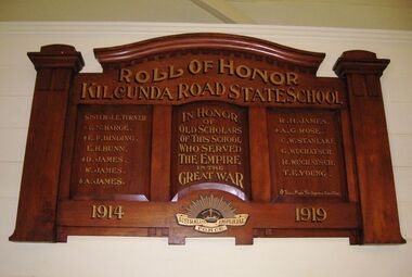 Coal Creek Community Park & Museum
Honour Roll, Kilcunda Road School Honor Roll
... building in the park display. On the west side of the intersection... building in the park display. On the west side of the intersection ...This WWI Honor Roll was originally displayed in the Kilcunda Road State School (no.3337), which was located at the north east corner of the intersection of the Bena - Kongwak and Buchanans' Roads, Bena, Victoria, 3946. The school was located amongst the cypress trees at 645 Bena-Kongwak Road. The school was relocated in 2008 to the Coal Creek Community Park and Museum, 12 Silkstone Road, Korumburra, 3950 to become the Masonic Lodge building in the park display. On the west side of the intersection of the Bena - Kongwak and Buchanans' Roads is a brass plaque on a granite boulder with the following inscription TO COMMEMORATE THE DISTRICT OF KILCUNDA ROAD First Surveyed 1879. This is the site of the KILCUNDA ROAD UNITING CHURCH 1911 to 1966. Diagonally opposite at 645 Bena-Kongwak Road was the site of the KILCUNDA ROAD PRIMARY SCHOOL No: 3337, 1902 to 1975. Erected by The School Mother’s Club continuing as The Kilcunda Road Social Club 2008. One of the few remaining historic items from Kilcunda Road settlement.Honour roll of varnished wood, with three panels, an undulating shaped pediment, plain columns at sides, painted gold text and the Australian Imperial Forces insignia on base.Roll of Honor, Kilcunda Road State School. In Honor of Old Scholars of this school who served the Empire in the Great War, 1914-1919, Australian Imperial Force. (X) These made the supreme sacrifice. Sister J.E. Turner , E.N. Barge, E.F. Binding (X), E.H. Bunn, D. James (X), W.James, A. James (X), R. H. James, A.G. Rose (X), C.W. Stanlake, G. Wuchatsch, R. Wuchatsch, T.E. Young kilcunda road, honour roll, state school no.3337., wwi -
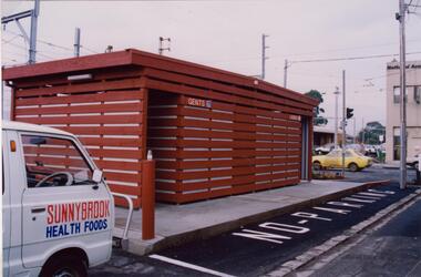 Glen Eira Historical Society
Photograph - Glenhuntly Road, Glen Huntly
... Huntly Road, north side west of the railway line. The photographs... block on Glen Huntly Road, north side west of the railway line ...Two colour photographs of a public toilet block on Glen Huntly Road, north side west of the railway line. The photographs may date to the 1980s though the exact dates are unknown. Photographer unknown.glen huntly road, glenhuntly, glenhuntly road, glen huntly, toilets, public conveniences -
Canterbury History Group
Photograph - New Theatre, Maling Road Canterbury, Jan Pigot, 1/03/1990 12:00:00 AM
... down March 11 1990, looking west from the side door..., looking west from the side door and the glass area looking ...Remains of the New Theatre, Maling Road Canterbury burnt down March 11 1990, looking west from the side door and the glass area looking at the inside of the Maling Road wallcanterbury, maling road, theatres, new theatre -
 Kiewa Valley Historical Society
Folder - Kiewa Methodist Church, 1917 to 1962
... on the west side was a Presbyterian Manse for many years and the block... for by an annual area collection.The house on the west side ...The copy of a letter written by Harry H. Simmonds of Huon notes that "the church existed in 1905. It was built by Hill and McCormack with timber donated by Mr Ned Dunstan on ground donated by Mr James Thomas probably in the late 1800s. It was possibly called a Methodist Church because the donor of the land was a Methodist. It was used by the three Protestant Groups and maintenance was paid for by an annual area collection.The house on the west side was a Presbyterian Manse for many years and the block of ground on the north side was known as the Manse paddock in which the minister grazed his cow and horse." In 1936 there was a fence between the Kiewa Methodist Church was the Presbyterian Church in Kiewa. Its Certificate of Title is Volume 5134 Folio 1026783 (Sept. 1942.) In 1952, the church was made of wood with an iron roof. In 1954. Request to Yackandandah Shire re a fence from Kiewa Consolidated School entrance to the unused hedge adjacent to the Church. In 1958 there was correspondence re 'the strip of land on each side of the Church.' Churches were an important part of life during the late 19th century and early to mid 20th century and were built in the centre of town as was this one. These papers give an understanding of the work involved in maintaining a church. The letters and 'book' give a lot of names of local families involved with the Methodist Church at Kiewa. Yellow plastic spiral folder with 18 pages enclosed in clear plastic sleeves.Papers enclosed include accounts, payments, tenders and other correspondence relating to the Methodist Church at Kiewa dating from 1932 to 1962. Of particular interest is a black cardboard cover book dated 1917 re collection of donations from listed people. The latest date in the book is 1942.Enclosed in first plastic sleeve is a letter from the donor, Kathie Vines dated 15th July 2013methodist church; kiewa; harry h. simmonds; yackandandah council; -
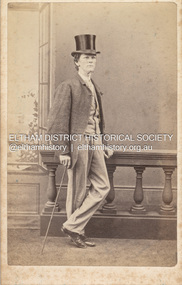 Eltham District Historical Society Inc
Photograph, Charles Rudd, Possibly Samuel Shillinglaw, c.1871
... Charles Rudd took over from W. Bear on the west side of Chapel... Charles Rudd took over from W. Bear on the west side of Chapel ...Samuel Shillinglaw was born at Merri Creek, Victoria, September 27, 1848. He married Agnes McIntosh at Windsor, January 9, 1878 and died at Prahran, September 13, 1925. Photographer Charles Rudd took over from W. Bear on the west side of Chapel Street, Prahan and was in business at this location from 1871-1872 (Sands McDougall Melbourne Directory) A duplicate photo is contained in Album 2 (05664) CARTE-DE-VISITE (cdv) 1857-1890 Cartes-de-visite (cdv's) are the most common form of photograph from the nineteenth century, generally measuring two and a half inches by four and an eighth inches (6.3 x 10.5 cm) when mounted, sepia toned, mounted on a card which was generally printed with the photographer's name and address on the back or beneath the portrait. - Frost, Lenore; Dating Family Photos 1850-1920; Valiant Press Pty. Ltd., Berwick, Victoria 1991marg ball collection, shillinglaw family photo album 1, 1871, 1871-1872, c. rudd & co photographers chapel street prahran, samuel shillinglaw (1848-1925) -
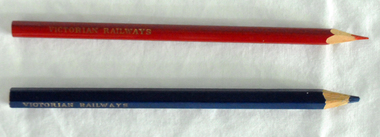 Orbost & District Historical Society
pencils, 1960's
... on the west side of the Snowy River despite the town of Orbost being... on the west side of the Snowy River despite the town of Orbost being ...These pencils were supplied to the Orbost railway Station office to be used for clerical work. They were used by Victor Smithers who was the Assistant Station Master at Orbost from 1957 - late 1960's. He was also a reliever until the 1970's after which he returned to Ormond Station on the Frankston line where he worked until his death in 1979. The Bairnsdale-Orbost railway was opened in 1916 to serve the agricultural and timber industry. Because of the decline in traffic and heavy operating costs, the line was finally closed in August, 1987. Orbost Railway Station was opened on Monday 10 April 1916 as the terminus of the Orbost railway line, and closed in 1987. The station was located on the west side of the Snowy River despite the town of Orbost being on the east side of the river, in order to save on the costs of a bridge over the river, which at the time had highly variable levels. This item is associated with the history of the Orbost-Bairnsdale railway line and therefore reflects the role that the rail line played in the social and economic history of Orbost.Two coloured pencils. 2580.1 is a hexagonal blue pencil and has "Wolff's Emperor MADE IN AUSTRALIA". 2580.2 is a round red pencil with "Wolff's Fintorex MADE IN AUSTRALIA coloured copying". Both have "VICTORIAN RAILWAYS" marked in gold lettering on the sides. orbost-railway-station smithers-victor -
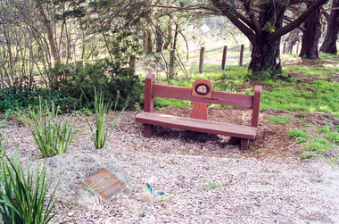 Eltham District Historical Society Inc
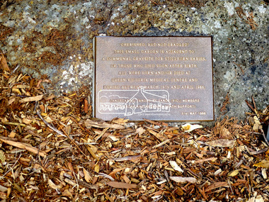
Photograph, Memorial to still born babies, Eltham cemetery, August 2007
... on the west side of Eltham cemetery, Mt Pleasant Road, Eltham... on the west side of Eltham cemetery, Mt Pleasant Road, Eltham ...A memorial to still born babies lies under the trees on the west side of Eltham cemetery, Mt Pleasant Road, Eltham. A plaque within a garden bed states: “Cherished, but not cradled. This small garden is adjacent to a communal gravesite for stillborn babies, or those who died soon after birth. They were all born and /or died at Queen Victoria Medical Centre and buried between March 1979 and April 1986.” The landscaping was funded by Stillborn and Neonatal death Support (SANDS) Vic. Members. It also initially had a low wooden seat in place. (No longer in place April 2022) The Queen Victoria Medical Centre itself was founded in 1896 and at the time was one of only three hospitals worldwide founded, managed and staffed by women. The Centre has since merged and amalgamated with the Monash Medical Centre. EDHS records also indicate that it was also a communal gravesite for bodies that were donated to science. Roll of 35mm colour negative film, 6 stripsKodak GC 400-9eltham cemetery, communal grave, stillborn, memorial to still born babies, women in eltham cemetery tour, memorial, garden, sands, stillborn and neonatal death support -
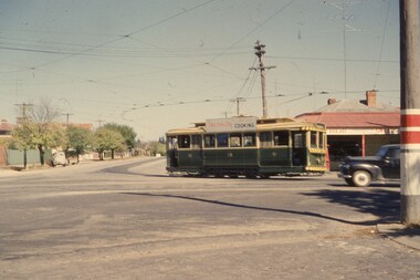
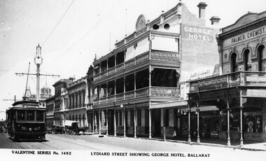 Ballarat Tramway Museum
Photograph - Black & White Photograph/s and Digital Image, Valentine & Sons Publishing Co, "Lydiard Street showing George Hotel Ballarat", 1931
... scheme, buildings on the west side of Lydiard St North, including..., tram 27 in ESCo colour scheme, buildings on the west side ...View of the early 1930's of No. 27 inbound in Lydiard St Nth. Valentine series No. 1492, with caption "Lydiard Street showing George Hotel, Ballarat". See page 59 of The Golden City and its Tramways and for the photo itself. Photo shows the wooden centre poles, street lighting, tram 27 in ESCo colour scheme, buildings on the west side of Lydiard St North, including the George Hotel, A.M.Palmer & Co Chemist, Wm Hiscock Dentist and other buildings. A horse drawn cart and two motor cars parked at the kerb. See item 8983 for the actual postcard. 3893.1 - Digital image from the Wal Jack Ballarat Album of the same photograph. Wal album notes date the photograph as 1931.Image i2 for the rear of the postcard, Image i3 for high res scan of the postcard. Copy negative image i4 added 3-5-2020.Yields information about Lydiard St Nth in the 1930's, the centre poles, traffic and the appearance of the trams.Black and White copy photograph of a Valentine Series postcard.tramways, trams, esco, lydiard st nth, george hotel, tram 27 -
Bialik College
Document (series) - Drama and musical production programs and promotional material, 1980s-2010s
... , The Survivor, Circus Bialikus, West Side Story, A Man for All Seasons..., The Survivor, Circus Bialikus, West Side Story, A Man for All Seasons ...1990s, 2000s, 2010s1990s, 2000s, 2010s -
 Eltham District Historical Society Inc
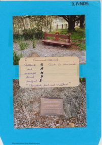
Document - Folder, Harry Gilham, Communal Gravesite, Eltham Cemetery, 2009-2010
... lies under the trees on the west side of cemetery. A plaque... lies under the trees on the west side of cemetery. A plaque ...Information page with photos about the memorial to still born babies at Eltham cemetery, Mt Pleasant Road, Eltham which lies under the trees on the west side of cemetery. A plaque within a garden bed states: “Cherished, but not cradled. This small garden is adjacent to a communal gravesite for stillborn babies, or those who died soon after birth. They were all born and /or died at Queen Victoria Medical Centre and buried between March 1979 and April 1986.” The landscaping was funded by Stillborn and Neonatal death Support (SANDS) Vic. Members. It also initially had a low wooden seat in place. (No longer in place April 2022) The Queen Victoria Medical Centre itself was founded in 1896 and at the time was one of only three hospitals worldwide founded, managed and staffed by women. The Centre has since merged and amalgamated with the Monash Medical Centre. H.G's research also indicated that the communal burial sites within Eltham Cemetery was also for bodies that were donated for science.communal graves, eltham cemetery, s.a.n.d.s., stillbirth and neonatal death support, memorial to still born babies, women in eltham cemetery tour, memorial -
 Eltham District Historical Society Inc
Photograph, Jim Connor, Memorial to still born babies, Eltham Cemetery, 1 Mar 2016
... on the west side of cemetery. The plaque within a garden bed states... on the west side of cemetery. The plaque within a garden bed states ...Plaque in the memorial to still born babies at Eltham cemetery, Mt Pleasant Road, Eltham which lies under the trees on the west side of cemetery. The plaque within a garden bed states: “Cherished, but not cradled. This small garden is adjacent to a communal gravesite for stillborn babies, or those who died soon after birth. They were all born and /or died at Queen Victoria Medical Centre and buried between March 1979 and April 1986.” The landscaping was funded by Stillborn and Neonatal death Support (SANDS) Vic. Members. It also initially had a low wooden seat in place. (No longer in place April 2022) The Queen Victoria Medical Centre itself was founded in 1896 and at the time was one of only three hospitals worldwide founded, managed and staffed by women. The Centre has since merged and amalgamated with the Monash Medical Centre. Records in EDHS files also indicate that the communal burial sites within Eltham Cemetery was also for bodies that were donated for science. Tomorrow's history documented todayeltham, jim connor collection, eltham cemetery, sands, stillbirth and neonatal death support, memorial to still born babies, memorial plaque, plaque, women in eltham cemetery tour -
 Eltham District Historical Society Inc
Negative - Photograph, Rose Stereograph Company, View at Eltham, Vic, c.1920
... . Henry Street road reserve on west side of Main road.... Henry Street road reserve on west side of Main road ...View at Eltham, Vic. Looking from Main Road near Henry Street towards Montmorency showing the railway trestle bridge. Henry Street road reserve on west side of Main road in foreground. c.1920 Copy of Rose Series Postcard P. 4348. (The Rose Stereograph Company) George Rose founded the Rose Stereograph Company in 1880 and was joined by Herbert (Bert) Cutts in the early 20th Century. The pair formed a lifetime working partnership and strong personal friendship. Assisted by George’s two sons, Herbert George and Walter, and later by Neil Cutts, the Rose Stereograph Company continued its operations for more than 140 years. The company was initially built on stereographs, but as cinema took over and stereographs fell out of fashion, the Rose Stereograph Company developed Australia’s first commercially viable photographic postcard business. Specialising in postcards of iconic historical moments and significant landmarks, The Rose Stereograph Company became a staple of the Australian travel industry. This photo forms part of a collection of photographs gathered by the Shire of Eltham for their centenary project book,"Pioneers and Painters: 100 years of the Shire of Eltham" by Alan Marshall (1971). The collection of over 500 images is held in partnership between Eltham District Historical Society and Yarra Plenty Regional Library (Eltham Library) and is now formally known as 'The Shire of Eltham Pioneers Photograph Collection.' It is significant in being the first community sourced collection representing the places and people of the Shire's first one hundred years.Digital image 4 x 5 inch B&W Negbridge street, eltham, eltham railway trestle bridge, postcard, rose stereograph company, shire of eltham pioneers photograph collection, trestle bridge -
 Wodonga & District Historical Society Inc
Photograph - Codling Collection 01 - Wodonga's Second Police Station
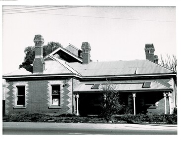
... - This building was located on the west side of High Street near... was located on the west side of High Street near the railway line ...Miss Olive Codling was a Foundation Member and a Life Member of the Wodonga Historical Society. Many of her prize-winning photos are held in the Society Collection. She also held a range of roles and committee positions in a wide range of Wodonga community organisations. WODONGA'S SECOND POLICE STATION - This building was located on the west side of High Street near the railway line at the corner of High Street and Bond Street. The building in the background was the Bond Store which was later repurposed to become the Court House. This Police Station, which began operation on this site c1905, had originally been the house of the customs officer. It had a front office and a Sergeant's and an Inspector's office as well as 2 barrack rooms and a laundry at the rear. In the backyard was a blue stone cell block and a night soil toilet, as well as a stable used previously for horse and carriage. Opposite the police station was a boarding house which supplied meals to prisoners. This police station was in use until its move to Elgin Street, Wodonga in December 1967.This photo collection is significant as it documents how the businesses and buildings in Wodonga have evolved and contributed to community throughout the 20th century.Two black and white photos of the 2nd Police Station built in Wodonga with the former Bond Store in the background.high st wodonga, police stations wodonga -
 Wodonga & District Historical Society Inc
Photograph - Codling Collection 01 - Wodonga's Second Court House
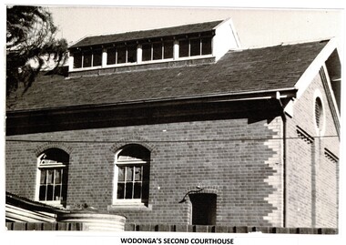
... . This was on the west side of High Street at its intersection with Bond Street.... This was on the west side of High Street at its intersection with Bond Street ...Miss Olive Codling was a Foundation Member and a Life Member of the Wodonga Historical Society. Many of her prize-winning photos are held in the Society Collection. She also held a range of roles and committee positions in a wide range of Wodonga community organisations. WODONGA'S SECOND COURTHOUSE The Court House was situated in the Customs or Bond Store building alongside the Wodonga Police Station in 93 High Street. This was on the west side of High Street at its intersection with Bond Street. The building was converted to the courthouse in 1920. In early 1964, the courthouse building was burnt beyond repair and furniture and other property destroyed. The cause of the fire was never found. The Police Station was lucky to survive but only because of the efforts of the local Fire Brigade. After the fire, the court was held first at the old Fire Station premises near where the present Wodonga Post Office, then it moved to a vacant building in Mitchell Street which was later turned into a Child Care Centre. Foundations for the new courthouse in Elgin Street were laid in October 1965.This photo collection is significant as it documents how the businesses and buildings in Wodonga have evolved and contributed to community throughout the 20th century.2 black and white photos of the Court House, formerly used as a Bond Store for collection of customs.high st wodonga, wodonga court house -
 Ballarat Tramway Museum
Photograph - Black & White Photograph/s, Harvey Studios, 18/02/1953 12:00:00 AM
... buildings on west side of Lydiard St. in photo. Published... park entrance. Provincial Hotel and other buildings on west ...Yields information about the tram arrangements for a large group from Geelong and the Geelong wharfies made for their picnic - probably at the Gardens. Demonstrates transport arrangements in the 1950's.Black and white photograph of seven bogie trams lined up with passengers boarding in Lydiard St. North, between Mair St and the Railway Station for the Geelong Waterside Workers picnic day on Wednesday 18/2/1953. Closest tram is No. 40. Photo taken from the Railway Station car park entrance. Provincial Hotel and other buildings on west side of Lydiard St. in photo. Published in the Courier 19/2/1953 - advised by Alan Bradley - 15/3/2003. 1880.1 - Digital image of the same photo from the Wal Jack Album. See images i2 and i3 for details, i3 for the rear of the photograph. Wal Jack notes identifies the trams as Nos. 15, 35, 39, 38, 34, 37, 40"On rear in blue ink "10 - Special trams chartered to convey Geelong Waterside Workers Picnic participants from Railway Station to Lake Wendouree Botanical Gardens o Wednesday 18 Feby '53". Under writing is word "Ballarat" in pencil. In top right hand corner, in a purple ink hand stamp is "N.L. Harvey (Photo Press Service) A.M.P. Chambers Lydiard St. N Ballarat" On rear of .1 is the N.L.Harvey stamp and Wal's notes "SEC Ballarat Geelong Wharfies Specials, Lydiard St Nth at 11.5am, 18-2-53, Nos. 15, 35, 39, 38, 34, 37, 40"trams, tramways, picnics, lydiard st. nth, geelong waterside workers, charters, tram hire, tram 40 -
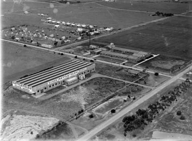
 City of Kingston
Photograph - Black and white, 20 December 1945
... in the 1990s as the west side addition to Southland. The densely... as the west side addition to Southland. The densely vegetated area ...This aerial photograph depicts the changing landscape of Cheltenham and Highett since WWII. Photographed in 1945, there is a mix of urban dwellings and industrial development and precedes the major transformation of Cheltenham with the development of the Southland shopping centre in the 1960s and expansion in the 1990s.A large part of Cheltenham was originally established as a rural market gardening community. The railway line and station brought urban development to the area and in the north, the Highett area was dominated by the Highett Gas Works. Cheltenham became a major destination for shopping in the 1960s with the opening of Southland.Aerial photograph taken in 1945 of Cheltenham and Highett within the City of Kingston. The image includes the Highett Reserve, (top right), the Methodist Children Homes (now Southland), Nepean Highway and Jamieson Street. Highett Gas Works is visible in the top left and the land now named William Fry Reserve at the intersection of Bay Road and Nepean Highway. A visible large parcel of land on the corner of Bay Road and Nepean Highway was developed in the 1990s as the west side addition to Southland. The densely vegetated area in the upper right sector of the image is now dense with housing. Tulip Grove, Heather Grove and Gilford Street are visible bottom left. This image is possibly from the collection of aerial photographs commissioned by the Department of Crown Lands and Survey and taken by Adastra Airways.Black ink: 57252 White lettering: VIC-10 57252 20.12.45 [lens information indecipherable] PROJ. No.5 MELB. METROP AREA Black pencil: 80highett, cheltenham, highett gas works, urbanisation -
 City of Kingston
Photograph - Black and white, 20 December 1945
... in the 1990s as the west side addition to Southland. The densely... in the 1990s as the west side addition to Southland. The densely ...This aerial photograph depicts the changing landscape of Cheltenham and Highett since WWII. Photographed in 1945, there is a mix of urban dwellings and industrial development and precedes the major transformation of Cheltenham with the development of the Southland shopping centre in the 1960s and expansion in the 1990s.A large part of Cheltenham was originally established as a rural market gardening community. The railway line and station brought urban development to the area and in the north, the Highett area was dominated by the Highett Gas Works. Cheltenham became a major destination for shopping in the 1960s with the opening of Southland.Aerial photograph taken in 1945 of Cheltenham and Highett within the City of Kingston. The image includes the Highett Reserve, (top right), the Methodist Children Homes (now Southland), Nepean Highway and Jamieson Street. Highett Gas Works is visible in the top left and the land now named William Fry Reserve at the intersection of Bay Road and Nepean Highway. A visible large parcel of land on the corner of Bay Road and Nepean Highway was developed in the 1990s as the west side addition to Southland. The densely vegetated area in the upper right sector of the image is now dense with housing. Tulip Grove, Heather Grove and Gilford Street are visible bottom left. This image is possibly from the collection of aerial photographs commissioned by the Department of Crown Lands and Survey and taken by Adastra Airways.Black type: Reverse lettering VIC-10 57252 20.12.45 [lens information indecipherable] PROJ. No.5 MELB. METROP AREA White lettering: Reverse writing 57252cheltenham, highett, highett gas works, urbanisation -
 Ballarat Tramway Museum
Slide - 35mm slide/s, Wal Jack, 23/03/1962 12:00:00 AM
... . north, taken from north west corner. Side on view of 18. Tram... north west corner. Side on view of 18. Tram fitted with dash ...Photo of No. 18 turning from MacArthur St. into Drummond St. north, taken from north west corner. Side on view of 18. Tram fitted with dash canopy lighting and SEC ad on roof. Adjacent to photographer is a compulsory tram stop painted on a pole with a white painted over section below it. Photo taken on 23-3-1962.'SEC Ballarat, No. 18 in Macarthur St., turning into Drummond St. 23-3-62' in blue inktramways, trams, macarthur st., drummond st., tram 18 -
 Parks Victoria - Wilsons Promontory Lightstation
Sheave Block/Pulley
... the lightstation.The first boat landing at the promontory was built on the west... the lightstation.The first boat landing at the promontory was built on the west ...Pulleys were used to lift goods to and from boats and at other sites at the lightstation where hauling was undertaken. Historical images and text panels in the Wilsons Promontory Museum attest to the detailed logistics that needed to be exercised in lifting and transporting goods once they had arrived by boat at the Eastern Landing. Cranes and a flying fox were employed in the nineteenth century and updated versions of this equipment served well into the twentieth century. The first cranes to be employed at the site were built just after December 1857, when tenders were called to construct two cranes prior to the commencement of building the lightstation.The first boat landing at the promontory was built on the west side of the lighthouse, which the architect, Charles Maplestone sketched in June 1859, the same month that he announced the completion of the lighthouse. His drawing shows one of the cranes as a large structure built for heavy duty lifting. Soon the east landing became the preferred place for delivering stores, but as late as 1993 a crane, timber structures and disused heavy iron machinery remained at the old site.Large rusted iron pulley, large loop at one end and smaller loop at the other. No hook.(Sheave Block) -
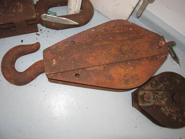 Parks Victoria - Wilsons Promontory Lightstation
Sheave block/ pulley
... on the west side of the lighthouse, which the architect, Charles... on the west side of the lighthouse, which the architect, Charles ...Pulleys were used to lift goods to and from boats and at other sites at the lightstation where hauling was undertaken. Historical images and text panels in the Wilsons Promontory Museum attest to the detailed logistics that needed to be exercised in lifting and transporting goods once they had arrived by boat at the Eastern Landing. Cranes and a flying fox were employed in the nineteenth century and updated versions of this equipment served well into the twentieth century. The first cranes to be employed at the site were built just after December 1857, when tenders were called to construct two cranes prior to the commencement of building the lightstation.180 The first boat landing at the promontory was built on the west side of the lighthouse, which the architect, Charles Maplestone sketched in June 1859, the same month that he announced the completion of the lighthouse.His drawing shows one of the cranes as a large structure built for heavy duty lifting. Soon the east landing became the preferred place for delivering stores, but as late as 1993 a crane, timber structures and disused heavy iron machinery remained at the old site.Large iron pulley with loop at one end and hook at the other, rusted. -
 Sunshine and District Historical Society Incorporated
Photograph - Three Old Sunshine Factories, Pratt, Charles Daniel, (1892 - 1968), Photographed circa late 1920's to early 1930's
... on the west side of McIntyre Road and Spalding on the east. Phoenix... on the west side of McIntyre Road and Spalding on the east. Phoenix ...These three factories clustered together and close to Albion Station provided manufacturing type of employment for several decades. All the factories have now disappeared and have been replaced by retail or service businesses. Spalding has been replaced by a Bunnings Hardware store, while the main retail outlet on the Nettlefolds site is Harvey Norman. Ironically part of the Phoenix Fireworks site is now occupied by the Metropolitan Fire Brigade, as well as other small businesses including a smash repair business, and a tyre retailer.The photograph provides a historical record of some of the types of manufacturing industries that existed in Sunshine, before retail or service industries began to replace them. Many of the younger generation do not know that fireworks, screws, or some sports items were manufactured in Sunshine not so long ago, and where the factories existed.The image depicted in this photographic copy is believed to be from circa late 1920's to early 1930's, and shows the NETTLEFOLDS, SPALDING, and the PHOENIX FIREWORKS factories. These factories were located in North Sunshine on the north side of Ballarat Road near Albion Station. Nettlefolds and Spalding are on the corner of Ballarat Road and McIntyre Road, with Nettlefolds being on the west side of McIntyre Road and Spalding on the east. Phoenix Fireworks factory is composed of small huts, and is situated on the north side of Phoenix Street at the rear of the Spalding factory. The photograph also shows a row of residential houses on Garnet Street which is on the east side of the Phoenix factory. Ballarat Road is still an undivided road and on the south side is a plantation of trees that once stretched from near Albion Station to Anderson Road. Other roads visible are Suffolk Road and Westmoreland Road.Nettlefolds Screw Worksnettlefolds, spalding, phoenix fireworks, screw works, ballarat road, mcintyre road, phoenix street, garnet street, westmoreland road, suffolk road. -
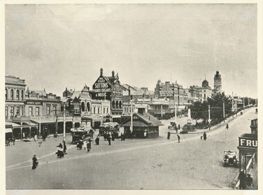 Ballarat Tramway Museum
Photograph - Black & White Photograph/s, c1912
... ." Buildings of the west side of Sturt St - W. Owen Sports Depot... of Sturt St." Buildings of the west side of Sturt St - W. Owen ...Yields information about the lower end of Sturt St, the tram terminal, the waiting shelter, the streetscape and how the street was used at the time.Black and white photograph of Sturt St. looking west from Grenville St, post 1912? Shows two ESCo trams, with driver's windows, advertising boards and trams converted for one man operation adjacent to the Grenville St. shelter. A motorcar is parked on the north side of Sturt St (right hand side of photo). On the bottom of the item is the words "Two Views of Sturt St." Buildings of the west side of Sturt St - W. Owen Sports Depot, Suttons Pianos, Organs and Music and the Mechanic's Institute. See Further information for Alan Bradley's notes on the shelter - ex an email dated 30/7/2004, following an enquiry from Max Harris. See Reg Item No. 1671 for the other "Two Views of Sturt St." image. Copy 2 - added 29/7/2007 from Alan Bradley collection of photographs, to the depot 5/2007. On rear of copy 2 in pencil "Alan Bradley"tramways, trams, esco, sturt st., ballarat, grenville st -
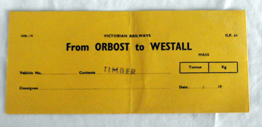 Orbost & District Historical Society
railways envelope, C 1980's
... , and closed in 1987. The station was located on the west side..., and closed in 1987. The station was located on the west side ...This item was used by Victorian Railways 1970's/1980's. It was used at Orbost Railway Station for the consignment of timber from Orbost to Westall.. Westall was a major timber-receiving depot near Dandenong, Victoria. Westall railway station is located on the Pakenham and Cranbourne lines in Victoria, Australia. It serves the south-eastern Melbourne suburb of Clayton South, opening on 6 February 1951. Westall station was opened as a workers only platform on 16 October 1954. It was provided for the adjacent Martin & King railway coachbuilding factory. The station was opened to the public on 1 June 1959 when all trains on the line began stopping there. The Bairnsdale-Orbost railway was opened in 1916 to serve the agricultural and timber industry. Because of the decline in traffic and heavy operating costs, the line was finally closed in August, 1987. Orbost Railway Station was opened on Monday 10 April 1916 as the terminus of the Orbost railway line, and closed in 1987. The station was located on the west side of the Snowy River despite the town of Orbost being on the east side of the river, in order to save on the costs of a bridge over the river, which at the time had highly variable levels. This item is associated with the history of the Orbost-Bairnsdale railway line and therefore reflects the role that the rail line played in the social and economic history of Orbost.An unused brown/buff coloured goods/freight consignment envelope used by Victorian Railways, this one for timber from Orbost to Westall. It is DL size.2497-78 VICTORIAN RAILWAYS G.F 63 From ORBOST to WESTALL MASS Tonnes kg Vehicle No Contents TIMBER Consignee Date orbost-bairnsdale-railway westall