Showing 4313 items
matching ? waller
-
 Melbourne Legacy
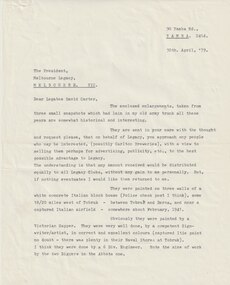
Letter, Tobruk Photos, 1979
Letters regarding three photos of murals in near Tobruk in Libya. The photos were sent to Melbourne Legacy in 1979 by Legatee Syd Wilson of Yamba NSW. He thought Melbourne Legacy might be able to use them to generate money by selling them for advertising or publicity. He said they were enlargements of snapshots he had found in his old army trunk. Legatee Wilson's letter says the murals were: 'painted on three walls of a white concrete Italian block house (Police Check post I think), some 18/20 miles west of Tobruk, between Tobruk and Derna, and near a captured Italian airfield, somewhere about February 1941. Obviously they were painted by a Victorian Sapper. They were very well done, by a competent Sign-writer/artist, in correct and excellent colours (captured Itie paint no doubt - there was plenty in their Naval Stores at Tobruk).' (NB Itie was slang for Italian) From the AWM website the signs were painted by South Australian painter, SZ538 Sapper Leslie John “Doc” Dawes, 2/3rd Field Company, Royal Australian Engineers. There are several photos on the AWM site including the building the three murals were on.Photos taken by a Legatee when on active service in Libya in World War 2 and donated to Legacy when it was thought they could be used for fundraising, which shows that Legatees were conscious of that Legacy needs to generate funds to continue its work.Black and white enlargement of a photo taken in Libya of Abbotts Lager mural.tobruk, murals -
 Vision Australia
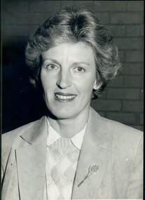
Photograph - Image, Diana Jones with tennis pin, 1985
Diana Jones (1939-2009) was President of the Association for the Blind from 1985 until 1992. In her 8 years as President a great deal was accomplished. New centres were opened or extended throughout Victoria and the Metropolitan area, volunteer services expanded and the Vision Resource Centre at Kooyong was built into which 3RPH radio was relocated. A Vision Information hotline, audiology services and the National Centre for Ageing and Sensory Loss were established, the Braille and Talking Book libraries was incorporated into the Association and the Charlie Bradley Cricket Pavilion opened at Kooyong. In 1990 Diana Jones became a member of the first Board of Directors of the newly incorporated Association for the Blind Ltd which ushered in a new era, requiring strict observance of financial and accounting methods in order to ensure continued Government funding. Mrs Jones was highly regarded by clients, volunteers and staff as a capable hard-working leader. Her services to the Association and over many years to the wider community, were recognised in her appointment as a Member of the Order of Australia in the 1993 Queen's Birthday Honours. In this image she stands inside, with a brick wall behind her, wearing a suede jacket, diamond pattern jumper, white shirt and a jewelled tennis racquet pin on her lapel.Diana Jones wearing a jacket, diamond patterned jumper and tennis racquet pin on her lapel1404.2 and 1404.3 on backdiana jones, association for the blind -
 Ringwood and District Historical Society
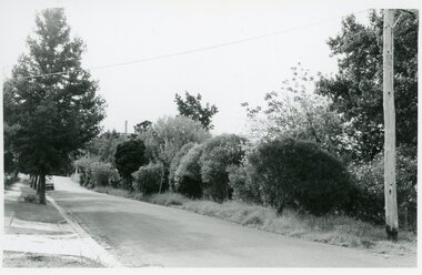
Photographs, Suda and Khassa Ave Ringwood, Before and after Ringwood Bypass Construction 1993
B&W photograph taken by Ringwood Historical Research Group. Also added extract from Melways showing the roads before the Bypass (1987) showing the planned Bypass cutting these two roads, and Melways (2018) showing new alignment with Bypass11063A: 17.1.93 Suda Ave Still intact towards Maroondah Hwy. Taken near Khassa Pde 11063B: 17.1.93 Suda Ave. House gone. Near Khassa Pde 11063C: 17.1.93 Ringwood Bypass from cnr Khassa Pde and Suda Ave towards Mt Dandenong Rd 11063D: 17.2.93 Suda Ave. House gone. 11063E: 21.2.93 cnr Khassa Pde and Suda Ave. Direction of next cut for the Ringwood Bypass. Trees to go. 11063F: 21.2.93 Connection from ??? St to North end of Suda Ave 11063G: 22.2.93 Adelaide St to right (closed). Mile Ave in front and turning left. Note the grey wall along Miles St to support the new car park development. Shrub on left is in the bowling club. -
 City of Ballarat
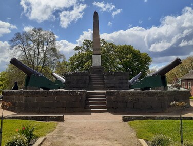
Artwork, other - Public Memorial, Eureka Monument, 1923
HistoricA sandstone plinth with tablet commemorating the Eureka Stockade Rebellion of December 3, 1854 including the names of diggers and soldiers whom fought and fell in battle, surrounded by a bluestone border. Set on a larger platform surrounded by four cannons and bluestone edge. Set in parkland with entry gateway at Eureka Street, Ballarat.Eureka Stockade Sunday Morning December 3rd 1854. This tablet was created by the Eureka Improvement Committee 1923. To honour the memory of the Heroic Pioneers who fought and fell, on this Sacred spot, in the cause of liberty. And the Soldiers who fell at Duty's call. Diggers: W. Emmerman, J. Diamond, T. O'Neill, J. Donaghey, W. Clifton, E. Quin, W. Quinlan, J. Hafele, J. Crowe, T. Moore, J. Brown, Lieut. Ross, J. Robertson, Fenton, E. McGlyn, J. Haynes, P. Gittins, T. Mullins, S. Green, R. Julien, E. Thonen, J. Hassle. Soldiers: Capt. H.C. Wise, Ptes. W. Webb, M. Roney, J. Wall, F. Boyle, J. Hall.eureka -
 Lara RSL Sub Branch
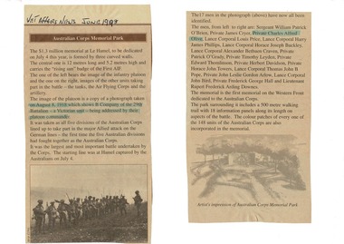
Veteran Affairs Newspaper article dated June 1998, Australian Corps Memorial Park - $1.3 million memorial at La Hamel for Australian World War 1 Soldiers
Article of World War 1 Refer to carved life size soldier with machine gun in foyer and photograph at its feet.A4 sheet of white paper has two cut-out sections of Veteran Affairs Newspaper article dated June 1998 glued on. Title Australian Corps Memorial Park. Article covers a Memorial cost $1.3 million dollars for dedication on 4th July 1998 consisting of three curved memorial walls for Australian soldiers that died during Wold War 2. The photograph included in the article was taken on August 8, 1918 which shows B company of the 29th Battalion - a Victorian Unit - being addressed by their platoon Commander. All 5 Australian Divisions took part in the major Allied attack on the German Lines - the first time the five Australian Divisions had fought together as the Australian Corps. (Under Australian Command) It is the First memorial on the Western Front dedicated to the Australian Corps. The park surrounding it includes a 500 meter walking tril with 18 information panels along its length on aspects of the battle.Article was found in Veteran Affairs News dated June 1998, heading - Australian Corps Memorial Park.veteran affairs news article, a4 paper sheet -
 Federation University Historical Collection
Plan, Burrumbeep, 1884, 16/10/1884
Auctions of Crown land were introduced in the Colony of Victoria from 1851 to encourage settlers to occupy and work the land. Many squatters purchased land at auction at the upset (minimum) price of £1 per acre. In some areas where demand was high, such as the goldfields, the price realised at auction was much more. Land was put up for sale in the study area on the Burrumbeep run in May 1855, on the Lexington run in 1857, and on the Gorrinn run in 1858. (http://www.ararat.vic.gov.au/library/document/thermatics.pdf, accessed 27 January 2015) For 70 years or more, Yalla-y-Poora, Burrumbeep, Edgarley, Mount William and Narrapumelap ranked in the leading wool producers in Victoria. 1 Stud owners at Yalla-y-Poora, Eurambeen, Burrumbeep and Challicum crossed merino sheep with sheep descended from John Macarthur's Camden Park in New South Wales. (http://www.ararat.vic.gov.au/library/document/thermatics.pdf, accessed 27 January 2015) In what was to become the Ararat Mining Division, gold was discovered in May 1854 on the Burrumbeep run at a place that became known as Pinky Point on the Mount William goldfield. By 21 June 1854, between 600 and 1,000 people had arrived. (http://www.ararat.vic.gov.au/library/document/thermatics.pdf, accessed 27 January 2015)\ Town allotment plan for Burrumbeep. Merrymbuela, Borung, Lexington and Langi Logan are neighbouring areas. The plan includes the Burrumbeep Pre-Emptive Right (Roger and Wright); licensed land holders including Stephen Young, John Carroll, William Walsh, Thomas Purcell, Martha M. Bond, Colin Johnson, John Charles Webb, Henry Withycombe, William Henry Barbridge, John Wall, Thomas Flatelly, William Jenkinson, Elisia Radford, V. Radford, Denis Byrne, George Cook. Land holders included Andrew Maloney, Richard Wingfield Harrocks, W. Sporton, Terence Lynch, F. S. Falkiner, A. Millman, H. Morris, George Upham, J. McCLure, S. Fletcher, W. Parker, Thomas Myers, William wright, W.C. Winter, C. Wordman, Oliver A. Winter This plan is associated with former Ballarat School of Mines student Richard Squire (1875-6) Gift of the Squire FamilyVerso written in pencil - Plan of Burrembeep Ararat Burrembeep Araratburrumbeep, corrinn, langi logan, merrymbuela, lexington, ararat, roger & wright, cook, rogers, upham, george upham, ross, parsans, morris, johnson, withycoombe, colin johnson, falkiner, dsporton, john carroll, donald gordon, denis bryne, maurice dooley, martha bond, william harricks, \william wingfield harricks, william l.c. harricks, michael houlihan, thomas purcell, martin ryan, michael cody, fletcher, mccaw, w. parker, j.m. clow, elisia radford, thomas radford, thomas myers, barbridge, e. wilde, j. wall, flatelly, g. wardman, w.c. winter, david ball, jenkinson, ballarat school of mines, richard squire, squire -
 Bendigo Historical Society Inc.
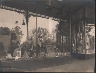
Photograph - HANRO COLLECTION: PHOTO OF SHOP FRONT DISPLAY WINDOW
Photo of shop Front Display Window: A black and white photo of large open windows with a central door. In the window on the left side wall is a display sign with *Hanro* A stand along display sign with a golfer swinging a club and two golf balls near by. Casual wear and shirts are displayed around with spools of thread. A Chair with cardigans is also displayed. Some plants are in the window and in the front is a sign with *Benknit Sports Wear for men and women, Product of Hanro (Aust) Bendigo Knitting Mills Pty Ltd. In the right window is a display of lingerie with yards of material draped through out the window. At the bottom of the photo is the imprint of the photographer *Bartlett Bros, Bendigo. A small tear at the top middle. The reflections in the windows is of the veranda with a lamp hanging from underneath and trees. On the back is the circular *Royal Historical Society of Victoria Bendigo Branch in blue ink. At the right top side in black ink in *MP368*. Box 116ABartlett Bros, Bendigo.photograph, streetscape, window display, hanro. -
 Bendigo Historical Society Inc.
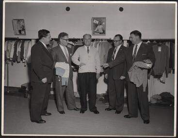
Photograph - HANRO COLLECTION: PHOTOGRAPH OF FIVE MEN IN THE SAMPLE ROOM AT HANRO'S
Photograph of Five staff in the sample room at Hanno's: Four staff members looking atone modelling a Hanro cardigan. Two of the staff hold knitwear. At the back of the men is a long rack of sample clothing. On the wall above the racks are two picture frames with women modelling a cardigan. On the back, hand written in blue ink is *Hanro Mills*. Typed in black ink is: *Left to Right: J. Batten, L. Ash, E. Stewart, J. Price, N Stapleton. A cream sticker with blue strip. In the strip is *Reg. V. Brook* top, and bottom in a blue strip *Of Bendigo*. In the middle No. *H1216. Pos. B* Additional copies may be obtained at any time by quoting this number. Also hand written in pencil is *CRV. Sept. D/C Charge: John Higgins Publicity, 42 William Street. Melbourne. At the top of the photo are two holes 7.3cm apart for storing in a folder. Box 116A -
 Bendigo Historical Society Inc.
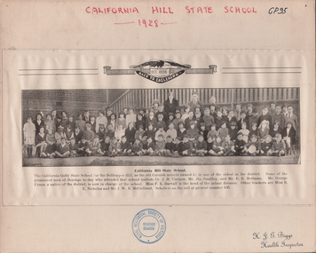
Photograph - STUDENTS OF CALIFORNIA HILL STATE SCHOOL, 1928
Black and white reproduction of photo from 'Back to Eaglehawk' back Oct. 1928. Large group of children, four adults in background. Outside. Banisters in background, brick wall at side. Approximately ninety children, youngest ones seated on ground at front, cross-legged. Inscriptions: on front - 'California Hill State School, 1928', 'JH Biggs, Health Inspector'. RHSV stamp (under photo). California Hill State School. 'The California Gully State School (or the Bell topper Hill, as the old Cornish miners names it) is one of the oldest in the district. Some of the prominent men of Bendigo today who attended that school include Cr. JH Curnow, Mr Jtn Smalley, and Mr EE Heitman. Mr. George Evans, a native of the district, is now in charge of the school. Miss FE Darvall is the head of the infant division. Other teachers are Miss RE Nicholas and Mr WR McClelland. Scholars on the roll at present number 105.person, group, students of cal. hill state.school -
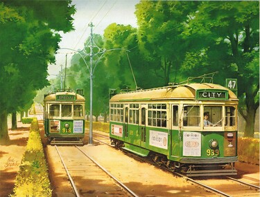 Ballarat Tramway Museum
Document - Calendar, Comeng Rolling Stock Division and Phil Belbin, 1984
testCalendar - large wall with clear plastic sheet - spiral wire bound at top issued by Comeng Rolling Stock division of ANI Corporation in 1985. Features 6 paintings by Phil Belbin. 1 - (Jan - Feb) NSW 8029 leading the southbound Intercapital Daylight out of the Bowral tunnel. 2 - (Mar - Apr) - trams 939 and 918 - Victoria Parade reserved track. 3 - (May - Jun) - South African Railways Blue Train 4 - (Jul - Aug) - VR S300 and 301 5 - (Sep - Oct) - QR 1298 on the Sunlander crossing a 2' gauge cane steam loco. 6 - (Nov - Dec) - Commonwealth Railways - Rawlina - Transcontinental train leaving Rawlinna - with the Tea and Sugar Train. For details of the artist see - https://en.wikipedia.org/wiki/Phil_Belbin (accessed 2-1-2018). See btm7022note from Bruce Belbin his son re use of the image. tramways, trams, art work, painting, victoria parade, railways -
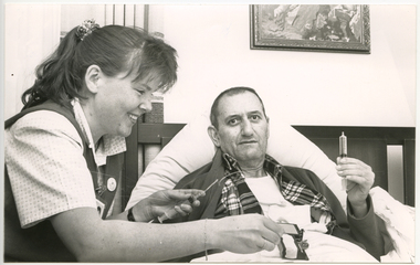 Royal District Nursing Service (now known as Bolton Clarke)
Photograph - Photograph, black and white, c.1990
RDNS Sister Marilyn Harper is giving medication via a syringe and tube to a male client..Medications ordered by Doctors in Hospitals was given by Royal District Nursing Service (RDNS) Sisters to patients in their own homes. Specialized treatments were taught to RDNS Sisters by the RDNS Education Department. At times RDNS Sisters visited hospitals to learn special techniques which were to be used to care for the patient after their discharge. The RDNS Education department ran many programs for their staff including: a Post Basic Course, Cardiac Rehabilitation Nursing, Haematology/Oncology Nursing, Palliative Care program, Diabetic Stabilization Program, Leg Ulcer Management Program, HIV/AIDS Nursing Care, Cystic Fibrosis Home Support, Veterans Home Care Program, Breast Cancer Support Program, Continence Management Program, Stomal Therapy Program, In-Home Lactation Support Program and a Community Nursing Education Program extended to student nurses from hospitals and to other nursing organizations. RDNS staff attended several hospitals to observe and learn special care needed to some clients, e.g. to the Austin Hospital to learn the care required for paraplegic and quadriplegic clients at home and to Mount Royal Hospital to observe the care of clients in the rehabilitation ward.On the left of the black and white photograph is the side view of Royal District Nursing (RDNS) Sister Marilyn Harper, who is smiling. She has drawn back long curly hair and is wearing a white patterned short sleeve blouse under a dark V neck tunic style frock. Her right arm is extended onto a piece of equipment resting on top of the bedclothes of a male client who is lying in bed. Her left hand is holding a partly emptied syringe which is attached to a clear coloured tube attached to the man. The male client, whose head and shoulders are resting on a boomerang pillow on his bed, has short dark hair and is wearing a tartan shirt and cardigan over a white T-shirt. He is holding an upright filled syringe in his left hand. In the background you can see part of the wooden bedhead and part of a picture on the pale coloured wall behind it.Courtesy of the 'Western Independent'royal district nursing service, rdns, rdns care - medication, sister marilyn harper -
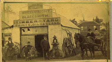 Bacchus Marsh & District Historical Society
Photograph, James Reid's Wheelwright and Blacksmith's Shop 1883
James Reid was born in Scotland near Glasgow and came to Victoria as a young man in 1854. Shortly after arriving he came to Bacchus Marsh where he lived until his death in 1902 at the age of 74 years. For most of these years he conducted a wheelwrights and coach builders business in Bacchus Marsh. In the nineteenth and early twentieth centuries, wheelwrights and blacksmiths played an essential role in the functioning of the whole community. Before the industrialisation of manufacturing, wheels and other components of vehicles for transport, all metal objects, including farm implements, building requirements and domestic utensils were made by hand. As mechanisation of industry increased, the smith commonly performed the role of farrier in the times when horse power was pivotal to all aspects of society. Complementing this work, the forge was often allied with a wheelwright's shop. These premises also acted as a meeting place for the men of the town, where news was shared and friendships forged.Small sepia 'carte de viste' style unframed photograph on card with gold border framing photograph. Housed in the album, 'Photographs of Bacchus Marsh and District in 1883 by Stevenson and McNicoll'. An image depicting a wheelwright and blacksmith's shop, with a group of men, boys and a woman shown in front. Two men are wearing the work clothes of the blacksmith, including the split leather apron worn by farriers to enable them to work on the hooves of the horses needing shoeing. Two young boys are standing by the door. A portly gentleman in formal clothes stands before the shop. His proprietorial air suggests he was James Reid, the owner. The house shown at the rear was James Reid's residence. Two people, an elderly gentleman and a younger woman, are seated in a jinker on the road to the side of the shop. A collection of wheels and farm tools leans on the walls. A triple-tiered sign above the shop reads: JAMES REID WHEELWRIGHT BLACKSMITH. TIMBER - YARD PAINTS, OILS & GLASS.Printed On the front: Stevenson & McNicoll. Photo. 108 Elizabeth St. Melbourne. COPIES CAN BE OBTAINED AT ANY TIME. On the back: LIGHT & TRUTH inscribed on a banner surmounted by a representation of the rising sun. Copies of this Portrait can be had at any time by sending the Name and Post Office Money Order or Stamps for the amount of order to STEVENSON & McNICOLL LATE BENSON & STEVENSON, Photographers. 108 Elizabeth Street, MELBOURNE.wheelwrights, james reid 1828?-1902, stevenson and mcnicoll 1883 photographs of bacchus marsh and district -
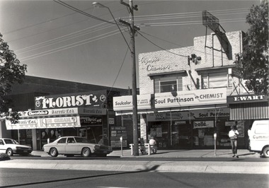 Wodonga & District Historical Society Inc
Photograph - Codling Collection 01 - Ewart Bros. Menswear, Soul Pattinson (previously Ken Moir), Darrell Lea, National Bank, Mid 1970s
Miss Olive Codling was a Foundation Member and a Life Member of the Wodonga Historical Society. Many of her prize-winning photos are held in the Society Collection. She also held a range of roles and committee positions in a wide range of Wodonga community organisations. These included the Horticultural Society, the Wodonga Arts Council, the Wodonga Camera Club and the Wodonga Lapidary Club. This photo collection is significant as it documents how the businesses and buildings in Wodonga have evolved and contributed to community throughout the 20th century.Geoff and Clarrie Ewart conducted a menswear business in High Street, Wodonga for 45 years. The pair began trading in 1954 at the southern end of the street before moving to a shop next to the Wodonga Pharmacy where they continued until 1995. They also opened Ewart's Book Store further south in High Street in 1961. Their second site became known as the 'long shop' as it extended from High Street and through to the Coles supermarket car park. They closed their menswear business in 1995. It was eventually absorbed by Coles when they extended their store, Jannoel Florist in Seasame Street was opened late 1973 - back then the Darrel Lea shop was Harry Johnsons shoe shop and after that it was Toyworld then it became Darrel lea before Jannoel bought Darrel Lea in 1998 knocked a hole in the wall and began combining flowers and chocolates Coles building was commenced on the site of Stiff and Gannon in March 1971 wodonga businesses, high st wodonga, ewart brothers, jannoel florist -
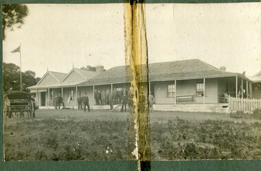 Orbost & District Historical Society
black and white photograph, C1900
The first settler to occupy the Marlo township area was James Stirling around the year 1875. He built a bark hut on the bluff that had two rooms, bark walls, earthen floors and a shingle roof. By 1884, this structure had expanded to a 9 roomed accommodation house and in 1886 became the Marlo Hotel when a liquor license was granted. The Governor-in-Council declared Marlo to be a township on 18 February 1889. During May 1889, the government surveyor, E.L. Bruce set out 19 sections of the new township, with the first sales of subdivided land occurring the following May. At this time, Stirling's Marlo Hotel was the unofficial hub for the community. It was a general store, accommodation house and the unofficial post office, with settlers taking turns in bringing the mail from Orbost or Cunningham. This continued until Aug 1942, and in 1969 was located in a house adjacent to the Marlo Hotel, before being transferred to the Marlo General Store in this year. The official Post Office List states the Marlo Post Office opened around 1902. in 1925, the "Marlo House" (a nine room accommodation guest house) was granted a liquor licence. The "Marlo House" became "The Marlo Hotel". The Marlo Hotel was popular with many Orbost and district settlers, who travelled to Marlo by horseback or buggy. The Marlo Hotel, perched on the hill overlooking the estuaries and the entrance is a significat building in Marlo. Established in 1886, it has been operating for over 120 yearsA black / white photograph of the Marlo Hotel. Patrons are standing on the verandah and lawns. A horse-drawn carriage is on the left. The photograph is on a green buff card with a rough edge on R H side.on back - " Old Marlo Hotel"marlo-house marlo-hotel stirling-james -
 Orbost & District Historical Society
black and white photograph, C 1900
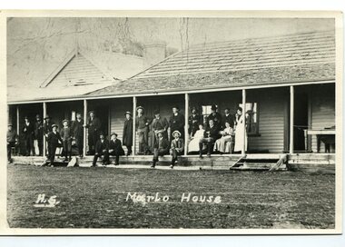
The first settler to occupy the Marlo township area was James Stirling around the year 1875. He built a bark hut on the bluff that had two rooms, bark walls, earthen floors and a shingle roof. By 1884, this structure had expanded to a 9 roomed accommodation house and in 1886 became the Marlo Hotel when a liquor license was granted. The Governor-in-Council declared Marlo to be a township on 18 February 1889] During May 1889, the government surveyor, E.L. Bruce set out 19 sections of the new township, with the first sales of subdivided land occurring the following May. At this time, Stirling's Marlo Hotel was the unofficial hub for the community. It was a general store, accommodation house and the unofficial post office, with settlers taking turns in bringing the mail from Orbost or Cunningham. This continued until Aug 1942, and in 1969 was located in a house adjacent to the Marlo Hotel, before being transferred to the Marlo General Store in this year. The official Post Office List states the Marlo Post Office opened around 1902. in 1925, the "Marlo House" (a nine room accommodation guest house) was granted a liquor licence. The "Marlo House" became "The Marlo Hotel". The Marlo Hotel was popular with many Orbost and district settlers, who travelled to Marlo by horseback Perched on the hill overlooking the estuaries and the entrance, the Marlo Hotel is a significant building in Marlo. It was established in 1886 and has been operating for over 120 years,A black / white photograph of Marlo House with staff and patrons standing and sitting on the verandah.on front - "H.S. Marlo House"marlo-house marlo-hotel -
 The Beechworth Burke Museum
Photograph
The photograph, captured around 1900, depicts a large group of minors located in Beechworth. Importantly, this photograph can provide information into the clothing and fashion of minors during this period of history. These men wear loose fitting shirts which are mostly a pale white colour, several wear vests and/or jackets and loose fitting trousers with boots. The majority of men wear wide brimmed hats to protect their skin and eyes from the sunlight. One man has a wooden pipe in his mouth and a few have ties/neckerchief's tied around their necks. The outfits of these miners has the potential to provide insight into their social status, these men are all dressed equally which provides the notion that they are of equal societal standing. The outfits of these miners dating to the 1900s is not dissimilar to photographs of those captured in the 1880s. The location of this photograph is not easy to interpret, but the photograph is recorded to have been taken in the Beechworth region. Displayed in this image is some wild shrubbery and grass where the men are standing/sitting and behind the group is a tin wall or even tin building. At the end of 1899, companies were continuing to search for gold in Beechworth and the surrounds but these attempts were not overly successful. In the early 1900's Quartz mining was occurring but this was done by individuals or smaller parties. It is unclear if these men are mining for gold or for quartz.The search for gold is ingrained into the history of Victoria and therefore, the study of images like this one which portrays some of the miners who worked behind-the-scenes for these discoveries has the potential to reveal important information regarding society, fashion etc. The date when the photograph was taken is vague but it allows us to form a timeline of mining activities in the North East. This image is of important historical significance for its ability to convey information about society at the time, regarding fashion (which can potentially reveal social status) and mining in Beechworth in 1900. Black and white rectangular photograph printed on matte photographic paper mounted on board.Reverse: BMM 8032/ Group(?) Beechworth Mines about 1900/ 80quartz, north east gold, sluicing, gold sluicing, hydraulic sluicing, mining, gold mining, north-east victoria, beechworth, burke museum, 1900, group, miners, hats, vests, ties, wild shrubs, tin, quartz mining -
 Eltham District Historical Society Inc
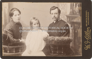
Photograph, M. J. Allan, Possibly Catherine Shillinglaw with Edward Henry Bottle and his daughter Ethel May Bottle, c.1890
Shillinglaw family members that were part of the Salvation Army included Elizabeth who married John Docherty in 1894, Catherine who married Edward Henry Bottle in 1897 and Jane who married William James Sommerville in 1887. Photographer Mark Joseph Allan operated from 318 Smith Street Collingwood from 1887-1901 Edward Henry Bottle previously married Eleanor Unsworth in 1875. They had four children, Edward John (1876), William Embassy (1879), Henry Charles (1881) and Ethel May (1883), all born at Bacchus Marsh. Eleanor (Ellen/Helena) died 1883 at Bacchus Marsh. He married Catherine Shillinglaw in 1897. CABINET 1866-1905 The Cabinet photo was introduced in 1866 in answer to a demand for a larger format photograph which could be mounted for a cabinet or on the wall. They were 4.5 inches by 6.5 inches (11.5 x 16.5 cm), more than twice the size of the cdv. They cost about twice as much as a cdv but eventually displaced them. They were not extensively produced until 1880 and had ceased by 1905. Coloured mounts, especially maroon or green, indicate a date between 1880 and 1890. - Frost, Lenore; Dating Family Photos 1850-1920; Valiant Press Pty. Ltd., Berwick, Victoria 1991marg ball collection, shillinglaw family photo album 2, cabinet photo, 1890, m.j. allan photographers 318 smith st collingwood, 1887-1901, catherine bottle (nee shillinglaw), edward henry bottle, ethel may bottle, salvation army, unknown -
 City of Moorabbin Historical Society (Operating the Box Cottage Museum)
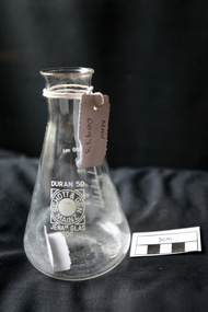
Manufactured Glass, Pharmacy beaker, c1950
Otto Schott, a chemist and glass engineer, had the vision of uniform production ie making glass items that would resemble one another. At the end of the eighteenth century, with most glass items still created by hand, the quality of output was still a guessing game. Schott was the first to render this an industrial certainty. 1884 Otto Schott, Ernst Abbe and Carl and Roderich Zeiss found the Schott & Associates Glass Technology Laboratory in Jena, Germany. Glastechnisches Laboratorium Schott & Gen was born. Production started in 1886. Original products included optical and thermometer glasses. The following year, a crucial discovery was made: borosilicate, a heat and chemically resistant glass. By it’s 25th year anniversary, the company had grown from an experimental glass factory into an internationally renowned manufacturer of optical and industrial glasses. Soon to be added was fiolax, tube-shaped glass used for vials, ampoules and syringes thus allowing the company to play a significant role in supplying Europe's nascent pharmaceutical industry. Post WW2 USA Army opens new factory in Mainz, West Germany and factory in Jena , East Germany taken over by the DDR State both using same trade name. Legal action for 30 years resolved in 1980 - split name. Berlin Wall 1989, Factories reunited 1991A pharmaceutical clear glass beaker with graduation 100ml -300ml DURAN 50Front : DURAN 50 / SCHOTT & GEN / MAINZ / JENA (ER) GLAS 300 Back : PYREX 300pharmacy, medications, medicines, glass manufacturing, glass works, early settlers, moorabbin, bentleigh, cheltenham, jenaer glaswerk schott & gen company, west germany, east germany, berlin wall, ww2 1939-45, schott otto, zeiss roderich -
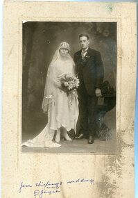 Orbost & District Historical Society
black and white photograph, July 1922
Jean Stirling , born 1901 in Orbost, married Charles Frances Reginald Joyes on 15th July 1922 in Orbost. Jean's father was John Stirling, son of James Stirling and Ann Gray. Her mother was Robina Harvey McNair, Aged 19 James Stirling arrived in Melbourne on January 26, 1842 with his family - parents, three sisters and two brothers. James Stirling moved around a lot to Whittlesea, Ballarat goldfields, Cunninghame, (now Lakes Entrance), then to the Old Station about 36 miles to the east along the coast near the mouth of the Snowy River and for a time settled there with his wife also from Wigton, Scotland, and their family four sons two daughters (James, John, William, George, Margaret and Polly). The first settler to occupy the Marlo township area was James Stirling around the year 1875. He built a bark hut on the bluff that had two rooms, bark walls, earthen floors and a shingle roof. By 1884, this structure had expanded to a 9 roomed accommodation house and in 1886 became the Marlo Hotel when a liquor license was granted. (more information from “Snowy River Mail”, Wednesday, April 13th 1977: MEMORIES OF MARLO by Mrs Elsbeth Conlon (nee Stirling )This photograph is associated with the Stirling family early settlers of Marlo. It is also a pictorial record of styles of wedding dress popular in the 1920s.A black / white studio portrait / photograph of a bridal couple. The bride on the left is wearing a typical 1920s wedding dress. tTe front is short with a hem that is in different length in front than behind. She is wearing a hat in the cloche-style. She is holding a bouquet of flowers and her train is draped to the left. The groom is wearing a three piece morning suit. he has a with a wingtip collar white dress shirt and a cravat tie.on front - hand - written "Jean Stirling's wedding (Marlo) ? Joyce"stirling-jean-wedding melba-&co wedding-clothing-1920s joyes-charles-francis-reginald -
 Orbost & District Historical Society
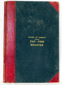
ledger, 1906
This ledger was used by the Shire of Orbost from 1906 to 1910. The item was donated to Orbost & District Historical society from P.R.O.V. as a Place of Deposit (POD) item for safe keeping by a local history group or museum. The shire covered an area of 9,347 square kilometres and existed from 1892 until 1994 when it became part of the East Gippsland Shire Council. Orbost was at first included in the Bairnsdale Shire from 1882 and was later part of the Tambo Shire. Because of travelling distances the Croajingalong Shire was created in 1892 (name changed to Orbost Shire 17.2.1893 with James Cameron as the first Shire President. In 1994 it amalgamated to become part of East Gippsland Shire Council. In Australian suburbs and rural towns where the sewer wasn't connected, people usually had an outside toilet. The toilet seat was made of a plank of wood secured at its ends to the walls of the building with a large round hole in the middle. Underneath was the removable sanitary pan and on a regular basis, usually weekly, the full pan was taken away and replaced with an empty one. This was the job of the sanitary carter. the sanitary depot was in Martins Lane, Orbost Development of the Orbost Wastewater Treatment Facility began in the 1960’s with the construction of four treatment lagoons. Shortly after the construction of the lagoons the sewerage system was installed throughout Orbost.This item is a record of accounting for the local government. The collection of sanitary pans was a necessary service before the Orbost township was had its own wastewater treatment facility.A large register of pan fees for the Shire of Orbost. A black hard cover book with red binding and marbled end pages. Entries are hand-written in black ink.On spine - "PAN FEES REGISTER: in gold lettering. In centre of front cover in gold - "SHIRE OF ORBOST (underlined) PAN FEES REGISTER"orbost-shire-council ledger-pan-fees sewage orbost-township-sanitary-service -
 Glen Eira Historical Society
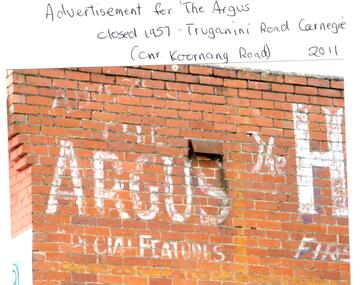
Photograph - CARNEGIE
24 photographs relating to Carnegie plus 1 slide: 1/Two photographs, one of Koornang Road c.1920’s and one of flower shop rear of library, date unknown. 2/One photograph of Carnegie Post Office c. undated. 3/Two photographs Koornang Road, Carnegie and phone boxes, Carnegie, dated 1914. 4/Two photographs (the same) of an RSL Ball dated 15/08/1937. 5/17 black and white negative photos – reprinted, date unknown, of Carnegie Library, shop front opening Koornang Road. 6/Slide showing Koornang Road, Carnegie looking South. 7/6 photocopied postcards from Valentines Real Photo Series, in album owned by Mrs. Zoe Mason, collected and returned to Pam Speedy (daughter) 12 Wattle Grove, East Malvern, 15/03/1999. Photocopied pages from 1923 Sands and McDougalls included with some prints to give an idea of architecture and other retail trade. 8/Two photocopied prints of Carnegie Flood. 1946 – Koornang Road, shows shopkeepers in street at that time. 9/Two photographs of brick wall advertising the "Argus" newpaper, which closed in 1957. Photos taken in 2011 when building was exposed prior to rebuilding on site.koornang road, rosstown road, carnegie, shepparson street, carnegie library, carnegie post office, mcallister b., glen huntly, glenhuntly, phone boxes, memorial hall, bamfield m., tranmere avenue, carnegie railway station, stations, libraries, post offices, memorial hall carnegie, progress hall, carnegie community singing, social clubs, chadstone progress, newspapers, temminghoff robert, carnegie chamber of commerce, caulfield city council, rob’s chocolate box, rosstown, ross william murray, rosstown railway, elsternwick, oakleigh, city of caulfield, glen huntly road, glenhuntly road, grange road, carnegie primary school, primary schools, murrumbeena, neerim road, dandenong road, koornang park, lord reserve, rosanna street reserve, packer oval reserve, caulfield swim centre, holywood grove, mile end road, mcpherson avenue, munster avenue, rosstown hotel, leila road, methodist church, toolambool street, carnegie theatre, carnegie estate agency – sims and broadbent, woorayl street, estate agents, cowie j. mrs., confectioner, woodhouse e., stationer, mckay jno. a., mckay jonathon, small goods, perry w. b., chemists, kinsman e. h., newsagents, jones a. w., mckee wm., furniture stores, neil geo. m., grocer, truganini road, brick -
 Robin Boyd Foundation
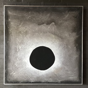
Painting, Asher Bilu, Solstar, 1968
Robin Boyd most likely saw Solstar at Asher Bilu's exhibition at South Yarra Gallery in September 1968. In November 1968, Robin Boyd arranged for the loan of this painting from South Yarra Gallery to Australian Pavilion at Expo '70 in Osaka, where Boyd was appointed Exhibit Architect. It hung in the bedroom over a bed, containing a life-size cut-out figure by Bruce Petty, in the Model House Interior exhibit on modern living in the Space Tube. On its return from Expo, the painting was in transit at the Boyd's home in Walsh Street and they liked it so much that they decided to buy it. Solstar originally hung on the wall at the end of the galley kitchen. The artwork at the Boyd's home in Walsh St has been moved several times over the years. Solstar now hangs above the dining table, but at the time of Solstar's acquisition, the Boyds hung the painting "Winter Triumphant" (1920) by Penleigh Boyd, Robin Boyd’s father, above the dining table. In early 2021, Asher and Luba Bilu visited Walsh St to view Solstar again. Asher was extremely happy with how the painting looked and its condition 53 years after painting it. He requested it be hung a little higher and he returned in April to make some minor restorations to remove scratches. Silver mixed media with large black circular area in the central lower half. On reverse has the title: Solstar/A. Bilu/Arrow showing which way up. Unsigned on the front.asher bilu, penleigh boyd, expo 70, osaka, robin boyd, south yarra gallery, walsh st artwork, ohm2022, ohm2022_13 -
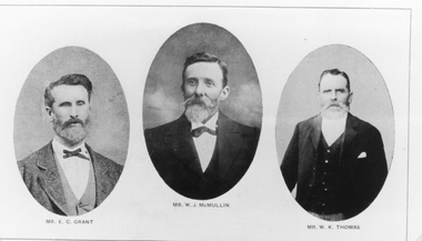 Stawell Historical Society Inc
Photograph, St Matthews Presbyterian Church with Mr E C Grant, Mr W.J. McMullin, Mr W.K. Thomas -- 3 Photos
E.C. Grant. W.J. McMullin. W.K. Thomas (Presbyterian) the 3 photos copied from Jubilee History 1860 -1911 St Matthews Presbyterian (Church Stawell). The Jubilee History was printed and taken from The Times, Main St. Stawell. Mr. E.C. Grant was Treasurer for 29 years. A tablet placed on the wall above the vestry door to perpetuate the memory of Mr. E. C. Grant, one of the greatest benefactors the church ever had. The inscription reads: In memoriam/ erected by the congregation of St Matthew's/ in memory of / The Stirling worth of / Edmund Craigie Grant/ who died 4th July 1894/ aged 63 years. He was a sincere Christian/ A most Liberal & generous giver/ and a true lover of his kind. / Well done good, and faithful servant Matthew XXV. v23. Mr. W.J. McMullin was a secretary of the Sabbath School - later became superintendent a position he held for 26 years. Up to the time of his death - Faithfully discharged his duties. Mr. W.J. McMullin had the distinction of serving as an elder for 26 years from 1883 until the time of his death in 1909. Mr. W.K. Thomas was leader of the choir which he conducted for 21 years - until his death 1901. Black & white photographs of oval shaped portraits of gentlemen. An enlargement is made of each individual. The gentlemen are formally dressed.Mr. E.C. Grant, Mr. W.K. Thomos, Mr. W.J. McMullin.stawell portrait -
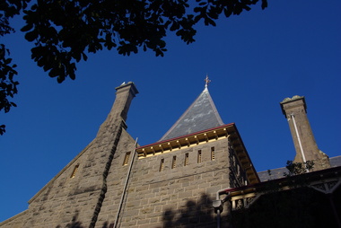 Ballarat Heritage Services
Photograph - Image - Colour, Clare Gervasoni, Bishop's Palace Ballarat Featuring Chimneys and Roof Line, Ballarat, 2014, 23/02/2014
Bishops Palace was built in 1877 as the home for the first Catholic Bishop of Ballarat. Designed by Melbourne architect, Joseph Reed, of Reed and Barnes, it was built by George Broom at a cost of £6,000. Reed and Barnes also designed Melbourne’s State Library, Ripponlea Estate and the Melbourne Royal Exhibition Building. The original heritage-listed gold lead stencilled paintwork that can be seen in the front entry and on the staircase walls at Bishops Palace was replicated in the Royal Exhibition Building. The original property was 140 squares set on 11 acres of gardens and took up an entire block of Sturt Street. This was on scale with the importance of Ballarat as a gold-mining centre at the time. Bishop's Palace is of architectural, aesthetic and historical significance to the State of Victoria. The two-storey bluestone mansion is an impressive example of 19th-century Gothic architecture with an unusual design. It retains many of its original features, including lead stencilled paintwork, cornices, ceiling roses, fixtures and fittings. Since sold by the Catholic Church the Bishops Palace has undergone a number of transformations in its lifetime, from the home of the first Bishop to a private residence, and today, as a luxurious accommodation, wedding and events venue. The grounds were subdivided over the years, and the property is now surrounded by four of the original 11 acres of gardens. It opened its doors to the public in 2019.Colour image of the bluestone Bishop's Palace, and it's cast iron lace.architecture, garden, bishop's palace, cast iron lace, cast iron, catholic church -
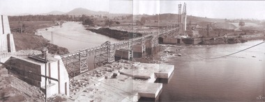 Wodonga & District Historical Society Inc
Album - Hume Reservoir Australia Album - General View of Works from New South Wales end, Looking Upstream, August 1927, 1927
This set of photos is from a leather bound album bearing the inscription "HUME RESERVOIR AUSTRALIA" plus 'The Rt. Hon. L. C. M. S. Amery, P. C., M .P.' all inscribed in gold. It was presented to The Rt. Hon. L. C. M. S. Amery, P. C., M. P, Secretary of State for Dominion Affairs on the occasion of his visit to the Hume Reservoir on 2nd November 1927. This album is of local and national significance as it documents the planning and development of the Hume Reservoir up to 1927. It was the largest water reservoir in the British Empire. The album records the pioneering engineering work that went into its construction.DEPARTMENT OF PUBLIC WORKS, N.S.W. RIVER MURRAY WATERS SCHEME. HUME RESERVOIR. 22. General View of Works from New South Wales end, Looking Upstream. Features: At the left, part of the North Wing Wall, the highest part of which is 26 feet below its ultimate height. Below in the foreground is the portion of the dam where provision is to be made for hydro-electric generation. The tubes, three in number, 13 feet in diameter, will be laid on the level shown and an early start will be made in laying them. The level for the other four regulating outlets, 9 feet in diameter, together with a part of the spillway section of the dam, is underwater at this stage and it may be remarked that at one point, about half way across the channel where the water is now flowing, the concrete foundations are about 80 feet below the level of the water. The broken surface of the water is due to the large “plums” in the concrete. The still water in the right foreground is the stilling pool over the concrete floor of which there is now more than 20 feet of water and by means of which the discharge from the outlet pipes will be quelled. The trestlework on the upstream side of the dam carries the concrete belt conveyor. It extends from the concrete mixer house, which is out of the picture, behind the wing wall, along almost the entire length of the concrete portion of the dam. The concrete is discharged from the belt at any desired point by means of trippers, one of which may be seen over the second trestle. On the other side of the flowing water is the coffer dam. A channel 300 feet wide involving about 140,000 cubic yards of excavation and dug for the temporary diversion of the river as it is flowing now. To the right top of the view beyond the Coffer Dam is the earth embankment being thrown across the major part of the valley by the Victorian Constructing Authority. The Mitta Mitta River flows into the Murray at the far end of the reach of water on the left. August 1927.hume reservoir australia, river murray waters scheme, hume reservoir construction -
 Eltham District Historical Society Inc
Photograph - Digital Photograph, Alan King, St Margaret's Anglican Church, Pitt Street, Eltham, 30 January 2008
St Margaret’s Church of England was officially opened on December 12, 1861. It is the oldest intact church building in Eltham. At the time it was known as Christ Church until its consecration in 1871, when it was completely free of debt (£1,700 for the church and parsonage) despite the district’s poverty. This was largely due to the free labour and materials, including locally made bricks donated by local artisans and others. The church is historically significant because it is the oldest church in the former Shire of Eltham and has associations with the philanthropist and founder of Brighton, Henry Dendy (who donated the land on which the church is built), the architect Nathaniel Billing and the prominent local builder, George Stebbing. The church is architecturally and aesthetically significant because it is constructed in the Gothic Revival style with several stained-glass windows of various dates and is also a very early use of polychromatic brickwork in Victoria. Billing was one of the first Melbourne architects to employ polychromatic brickwork and an important early architect. The rear wall was intended to be temporary. A major feature of the design is the large buttresses with long, steeply graded upper faces. The overall design is well proportioned with the surface brick patterns relieving an otherwise austere design. The church is spiritually and socially significant because it has been an important place of worship for the people of Eltham for almost 150 years. The land on which the buildings stand was donated by Henry Dendy. Dendy arrived in Melbourne in 1841 after purchasing in England eight square miles at Brighton under the system of "special surveys". After this land passed out of his hands, Dendy moved about Victoria, visited England, then returned to settle in Eltham where he purchased a flour mill. Dendy chaired the meeting held in 1860 “for the purpose of devising such means as may be expedient for the establishment of a Church of England in the township of Eltham”. He became chairman and treasurer of the church committee. Unlike the establishment of many early churches in Victoria where a vicar was appointed to a parish and later a permanent church was constructed, the population at Eltham initiated action to build a church. The nearest church at that time was at Heidelberg and the Eltham settlement was part of the parish of St Johns Heidelberg. Isolation and the tedious, time consuming journey between Heidelberg and Eltham resulted in the Eltham community taking its own action. The original vicarage (Dendy House) at the rear of the church is also an important part of the cultural significance of this place because it is connected to the church and the development of the Eltham area. Together, the church and the vicarage are aesthetically significant because they form a significant streetscape feature. The mud-brick community hall designed by Robert Marshall was added in 1978. In 2014 the original temporary rear wall was removed as part of a modern extension designed by Architects Atelier Wagner and constructed by Conrad Construction and Management. Covered under Heritage Overlay, Nillumbik Planning Scheme. National Trust of Australia (Victoria) State significance Victorian Heritage Published: Nillumbik Now and Then / Marguerite Marshall 2008; photographs Alan King with Marguerite Marshall.; p67This collection of almost 130 photos about places and people within the Shire of Nillumbik, an urban and rural municipality in Melbourne's north, contributes to an understanding of the history of the Shire. Published in 2008 immediately prior to the Black Saturday bushfires of February 7, 2009, it documents sites that were impacted, and in some cases destroyed by the fires. It includes photographs taken especially for the publication, creating a unique time capsule representing the Shire in the early 21st century. It remains the most recent comprehenesive publication devoted to the Shire's history connecting local residents to the past. nillumbik now and then (marshall-king) collection, eltham, st margaret's anglican church, st margaret's church, st margarets church hall, christ church -
 Eltham District Historical Society Inc
Photograph - Digital Photograph, Alan King, St Margaret's Anglican Church, Pitt Street, Eltham, 30 January 2008
St Margaret’s Church of England was officially opened on December 12, 1861. It is the oldest intact church building in Eltham. At the time it was known as Christ Church until its consecration in 1871, when it was completely free of debt (£1,700 for the church and parsonage) despite the district’s poverty. This was largely due to the free labour and materials, including locally made bricks donated by local artisans and others. The church is historically significant because it is the oldest church in the former Shire of Eltham and has associations with the philanthropist and founder of Brighton, Henry Dendy (who donated the land on which the church is built), the architect Nathaniel Billing and the prominent local builder, George Stebbing. The church is architecturally and aesthetically significant because it is constructed in the Gothic Revival style with several stained-glass windows of various dates and is also a very early use of polychromatic brickwork in Victoria. Billing was one of the first Melbourne architects to employ polychromatic brickwork and an important early architect. The rear wall was intended to be temporary. A major feature of the design is the large buttresses with long, steeply graded upper faces. The overall design is well proportioned with the surface brick patterns relieving an otherwise austere design. The church is spiritually and socially significant because it has been an important place of worship for the people of Eltham for almost 150 years. The land on which the buildings stand was donated by Henry Dendy. Dendy arrived in Melbourne in 1841 after purchasing in England eight square miles at Brighton under the system of "special surveys". After this land passed out of his hands, Dendy moved about Victoria, visited England, then returned to settle in Eltham where he purchased a flour mill. Dendy chaired the meeting held in 1860 “for the purpose of devising such means as may be expedient for the establishment of a Church of England in the township of Eltham”. He became chairman and treasurer of the church committee. Unlike the establishment of many early churches in Victoria where a vicar was appointed to a parish and later a permanent church was constructed, the population at Eltham initiated action to build a church. The nearest church at that time was at Heidelberg and the Eltham settlement was part of the parish of St Johns Heidelberg. Isolation and the tedious, time consuming journey between Heidelberg and Eltham resulted in the Eltham community taking its own action. The original vicarage (Dendy House) at the rear of the church is also an important part of the cultural significance of this place because it is connected to the church and the development of the Eltham area. Together, the church and the vicarage are aesthetically significant because they form a significant streetscape feature. The mud-brick community hall designed by Robert Marshall was added in 1978. In 2014 the original temporary rear wall was removed as part of a modern extension designed by Architects Atelier Wagner and constructed by Conrad Construction and Management. Covered under Heritage Overlay, Nillumbik Planning Scheme. National Trust of Australia (Victoria) State significance Victorian Heritage Published: Nillumbik Now and Then / Marguerite Marshall 2008; photographs Alan King with Marguerite Marshall.; p67This collection of almost 130 photos about places and people within the Shire of Nillumbik, an urban and rural municipality in Melbourne's north, contributes to an understanding of the history of the Shire. Published in 2008 immediately prior to the Black Saturday bushfires of February 7, 2009, it documents sites that were impacted, and in some cases destroyed by the fires. It includes photographs taken especially for the publication, creating a unique time capsule representing the Shire in the early 21st century. It remains the most recent comprehenesive publication devoted to the Shire's history connecting local residents to the past. nillumbik now and then (marshall-king) collection, eltham, st margaret's anglican church, st margaret's church, christ church -
 Flagstaff Hill Maritime Museum and Village
Equipment - Stevenson Screen, Thomas Stevenson, ca. 1910
Stevenson screens were first introduced in Australia in the 1880s and were widely installed by 1910. The screens have been used to shelter and protect thermometers and other meteorological instruments from rain and direct heat while the holes and double-louvre walls allowed air to flow around them. Sometimes other meteorological instruments were included in the weather stations, so there were different Stevenson Screen sizes. This authentic, original Stevenson screen was previously owned by the Australian Bureau of Meteorology and was used for many years for weather readings at the Cape Otway Light Station in southwest Victoria. The Lighthouse Keepers recorded the readings for minimum and maximum temperatures at 9 a.m. every day from January 1865 until April 1994. The equipment was sheltered in a Stevenson Screen from 1902 until April 15 1994, when the mercury thermometer was replaced by a platinum resistance probe within an Automatic Weather Station (AWS). This Stevenson screen is one of the two screens that then became redundant. The other Stevenson screen was kept to display to visitors. Lightkeepers were no longer required at the Cape Otway Light station either, due to the automated system. The meteorological instruments donated with the screen were used for measuring temperature and humidity. They are mounted on a metal bracket that fits across the screw holes on the screen’s internal frame. The glass-covered Relative Humidity (RH) sensor was made by the renowned precision instrument maker, Rotronic AG of Switzerland, which was founded in 1965. The firm made its first electronic temperature and humidity instrument in 1967. Meteorological records have been collected in Australia from the 1800s. The records were collated, published and used as a basis for weather forecasts. Many sectors, such as maritime and agriculture industries, have relied on these figures for making important decisions. The quality and placement of the meteorological instruments used to measure temperature and humidity are of utmost importance for accuracy. In early colonial times, there were no national standards for meteorological instruments that would allow for accurate figures and comparisons. Once the Bureau of Meteorology was established (around 1908 to 1910) the department installed Stevenson screens throughout Australia, many at lighthouses and light stations, and the measuring instruments were standardised. The Stevenson Screen was named after its inventor, Scottish Civil Engineer Thomas Stevenson (1818-1887) who was also the father of Robert Louis Stevenson, author. Stevenson developed the small thermometer screen around 1867. It had double-louvred walls around the sides and a top of two asbestos sheets with an air space between them and was thickly painted with a white coating that reflected the sun’s rays. This design was modified in 1884 by Edward Mawley of the Royal Meteorological Society. Standards were set for the locations of the screens and instruments, including their distance above ground level and the direction the door faced.Stevenson screens played a significant part in providing a standardised shelter for all meteorological instruments used by the Australian Bureau of Meteorology from about 1910 until 1994. The readings from the instruments gave the meteorological statistics on which weather forecasts throughout Australia were based. This Stevenson screen was used locally at Cape Otway, along the Great Ocean Road in southwest Victoria, so contributed towards our local forecasts and weather warnings.Stevenson screen, original, from the Australian Bureau of Meteorology’s weather station at the Cape Otway Lighthouse. The screen is a white wooden cupboard with a slanted cover raised above the top. The top has ten drilled ventilation holes, and the sides and door are made of downward-slanting double louvres. Two brass hinges join the door to the lower edge of the screen and a metal fitting at the top edge allows for a padlock closure. The screen is supported on four short legs, each with a hole drilled from side to side for fitting to a frame. Inside the screen are two wooden frames fitted with hooks and screws. The floor has three boards; one across the back and one across the front at the same level, and a board wider than the space between these boards is fitted higher, overlapping them slightly. Inside the screen, a pair of electronic instruments with short electric cables is mounted on a metal bracket with drilled holes in it. One of the instruments is a Relative Humidity (RH) probe. It is 26 cm long and is a glass tube with a filter on one end and an electrical connection on the other. It has inscriptions on its label, showing that was made by Rotronic AG, Switzerland. The other instrument is a Resistance Temperature Device (RTD) thermometer. It is 22.5 cm long and has a narrow metal probe joined to a hexagonal metal fitting. A brass plate on the front of the screen has impressed inscriptions. The screen is Serial Number 01/C0032, Catalogue Number 235862.Stamped into brass plate "CAT. NO. / 253862 / SERIAL NO. 01/C0032" On instrument’s electrical fitting; “CD2” [within oval ‘+’ above S] “Serie693 op65 / 220/380V~16A” On instrument’s glass; “rotronic ag” “SWISS MADE” “CE / CH-8303 / Bassersdorf” Symbol for [BARCODE] “ART NO MP 101A_T4-W4W” “POWER 4.8.30VDC“ “OP. RANGE: 0-100%RH/-40+60° C” “OUT H 0-100% 0-1V” “OUT T -40+60°C -0.4..+0.6V” “SERIE NO 19522 009”flagstaff hill maritime museum and village, warrnambool, maritime museum, maritime village, great ocean road, shipwreck coast, cotton region shelter, instrument shelter, thermometer shelter, thermoscreen, thermometer screen, measuring instruments, meteorological instrument, weather recording, weather station, lighthouse equipment, light station equipment, stevenson screen, marine instruments, mercury thermometer, platinum resistance probe, aws, automatic weather station, rotronic ag, swiss made, meteorological device, weather forecast, weather prediction, weather records, meteorological forecast, meteorological record, australian bureau of meteorology, bureau of meteorology, bureau, bom, relative humidity, rh, relative humidity probe, resistance temperature device, rtd, thermometer, temperature, humidity, cape otway, cape otway lighthouse, cape otway light station, rotronic, switzerland, swiss instrument, thomas stevenson, double-louvered walls, edward mawley, royal meteorological society, 01/c0032, serial number, cat. no. 235862, serial no. 01/c00323 -
 Federation University Historical Collection
Photograph (black & White), Major General, Sir William Penn Symons - South Africa
William Penn Symons' first combat experience was in South Africa during the Ninth Xhosa War, 1877-78. In 1879 he took part in the Zulu war. He then served during the Burma Expedition (1885-89). In 1889 he received the Companion of the Order of the Bath. In 1898, following other campaigns, he was awarded the Knight Commander of the Order of the Bath. In 1899, Symons was given the staff rank of brigadier general and was to be General Officer Commanding of Natal. He was asked by the War Office to advise on the number of troops required to safely garrison the Natal from the threat of invasion from the Boer Republics of the Transvaal and Orange Free states. Cabinet decided to send ten thousand extra troop abut they also appointed Lieutenant General Sir George White to supersede Symons as Generat Officer Commanding in Natal. Penn Symons, on his own authority deployed one of his brigades to Dundee, a town north of Ladysmith. The position of Ladysmith anad Dundee was precarious as they stand in a triangle of Natal, Orange Free State and Transvaal. White wanted to recall the Dundee garrison to Ladysmith but because of political pressure from Sit Walter Hely-Harrison, the Governor of Natal, he agreed to leave them there. The Boers declared war on 11 October and began crossing the Natal borders the following day. On 20 October 1899 Boer troops on the nearby Talana Hill proceeded to open fire on the town. The British guns moved to return fire as the general surveyed the Boer positions and gave orders to his commanding officers. Symons believed in old fashioned military tactics of close order but these formations were not designed to be used against lonf range bolt action rifles and Symons' brigades would be the first of manyin this war to pay the heavy cost ofthe mistake, as many generals would repeat it. The infantry battalions set off from the east of the town. The first part of the advance went well and they reached a small wood at the foot of the hill where they found shelter. Beyond the wood was a wall and then open ground. Symons rode up to the wood to find out why the attack had halted. He ordered the men to proceed, rode through the wood then walked through the gap in the wall. After a few moments he returned and was helped to remount his horse. He rode back from the front lines until he was out of sight of his troops before he asked for assistance from the Indian stretcher bearers. He had been shot in the stomach. Symons was taken to the field hospital at Dundee. After a few wasted days Symons' replacement, Brigadier General Yule, decided to abandon the town and the worst-wounded to the Boers and steal away at night to Ladysmith. Symons became a prisoner of war along with many others. He felt betrayed by Yule and just before he died he implored the medical officer, Major Donegal, to "tell everyone I died facing the enemy". Individual image from photographed poster of tobacco and cigarette cards.william penn symons, south africa, ninth xhosa war, companion of the order of the bath, knigt commander of the order of the bath, general officer commanding in natal, dundee, ladysmith, orange free state, transvaal, sir walter hely-harrison, governor of natal, boers, brigadier general yule -
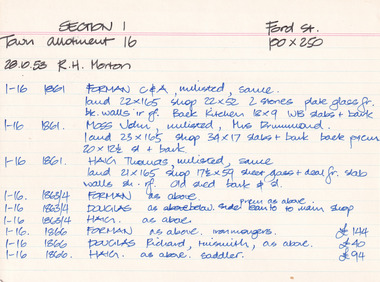 The Beechworth Burke Museum Research Collection
Card (Series) - Index Card, George Tibbits, Ford Street, Beechworth, 1976
George Tibbits, University of Melbourne. Faculty of Architecture, Building and Town & Regional PlanningIndex system that support the research for Beechworth : historical reconstruction / [by] George Tibbits ... [et al]Arranged by street names of BeechworthEach index card includes: street name and number of property, image of property, allotment and section number, property owners and dates of ownership, description of the property according to rate records, property floor plan with dimensions.beechworth, george tibbitsbeechworth, george tibbits