Showing 17165 items
matching bay-bridge
-
 Marysville & District Historical Society
Photograph (item) - Black and white photograph, Unknown
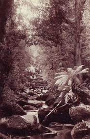
An early black and white photograph which shows a man and a woman standing on the bridge that crosses the Steavenson River at the base of the Steavenson Falls in Marysville in Victoria.An early black and white photograph which shows a man and a woman standing on the bridge that crosses the Steavenson River at the base of the Steavenson Falls in Marysville in Victoria. The Steavenson Falls are named after the Victorian Assistant Commissioner of Roads and Bridges, John Steavenson who arrived in Victoria in the early 1860s.steavenson river, steavenson falls, marysville, victoria, waterfalls, john steavenson -
 Sunbury Family History and Heritage Society Inc.
Photograph, 27 June 1934
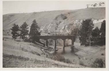
This is a photograph of the bridge in the Bulla township which spans the Deep Creek, a tributary of the Maribyrnong River. It has been constructed from bluestone which is found across the volcanic western plains in Victoria. Kaolin was quarried from the cliff face in the background and was used in the making of bricks and pottery products manufactured at Northcote and Brunswick potteries.This is one of the many notable bluestone bridges which were built in the district in the nineteenth century.A black and white photograph of a valley with a five arched bridge spanning a river. There are high cliffs in the background.bulla township, deep creek, bridges -
 Eltham District Historical Society Inc
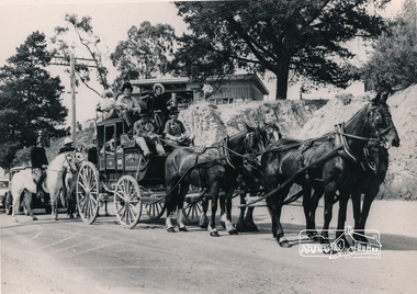
Photograph, Cobb and Co. Coach and horses, ERSILAC Parade, c.1960
Near the corner of Main Road and Bridge StreetBlack and white photograph featuring a Cobb and Co coach drawn by four horses with a full complement of passengers in period clothing. Taken near the corner of Main Road and Bridge Street. Part of a procession/parade.cobb and co, bridge street, ersilac parade, horse drawn carriage, main road -
 Rutherglen Historical Society
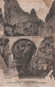
Image, Etablissement de photographie Giletia, c1910
Found at the rubbish tip. Written by Percy Fullerton during WWI, to his future wife Fern Aitken.Black and white photograph on postcard, showing an arched bridge in mountainous terrain.At bottom of photo: "13. Grimaldi (Italia) Ponte San Luigi - Frontiera Francia é Italia" On back of postcard: Postmark - "Grimaldi di Ventimiglia | Porto Maurizioi | 4.1.18" Message: "Dear Fern, Having quite a good time. This is being sent from the bridge as seen in PC. Regards to all, Percy" Address: "Miss F Aitken", 'Ferndale', Rutherglen, Victoria, Australia" percy fullerton, fern aitken, world war 1, world war i, ww1, wwi -
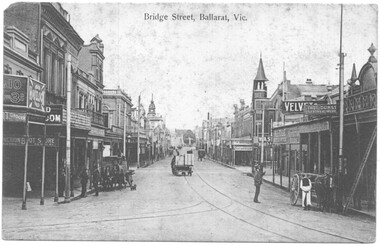 Ballarat Tramway Museum
Postcard - Bridge Sreet Ballarat Vic, VSM Melbourne
Postcard - Bridge Sreet, Ballarat Vic showing tram tracks, a number of horse drawn carts and cabs. On the far right, a tram stop sign can be seen, along with men talking. In the view are shops, businesses or advertisements for: Junction Boot Store, Havelock Tobacco, Halls Corner, A Bregeut Ales & Butter shop, W A Stark Wines and Spirits, Velvet Soap, Thomas Dunstan? Leather Merchant.Yields infomation about the corner of Bridge Street, Main Road and Victoria Streets.Black and white postcard titled Bridge Sreet Ballarat Vic, looking west from the corner of Bridge Street, Main Road and Victoria Streets 1910c. Divided back type, published by VSM Melboune and printed in Prussia.bridge street, ballarat, stones corner, victoria street, main road, tramways, tram track, horse drawn vehicles -
 Lakes Entrance Historical Society
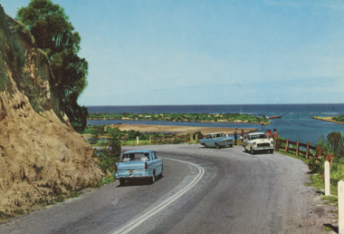
Postcard - Princes Highway Lakes Entrance, AFK International Publishers, 1970 c
Parking bay for viewing the Entrance situated on a sharp bend of the Princes Highway. Also in image part of Bullock Island and New Works area. Three motor cars in picture, post and rail safety fence Lakes Entrance Victoria. Also three colour postcards of same view showing progress at parking bay to steel mesh fence and steel guard rails numbers 04206.1, size 9 x 14 cm, 04206.2, 04206.3 size 10 x 14.5 cmColour postcard showing parking bay for viewing the Entrance situated on a sharp bend of the Princes Highway. Also in image part of Bullock Island and New Works area. Three motor cars in picture, post and rail safety fence Lakes Entrance Victoriacivil engineering, islands, waterways, gippsland lakes, vehicles -
 Sunbury Family History and Heritage Society Inc.
Photograph
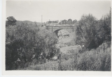
The single span bluestone bridge is on the Calder Highway at the base of Corkscrew Hill between Gap Road and the town of Gisborne. In the early 1990s the highway was widened and dual carriageways constructed, as a result the traffic no longer travelled along the winding Corkscrew Hill road. The bridge still stands between the two carriageways. A black and white photograph with a cream border of a single arched stone bridge spanning a watercourse. Small bushes are growing in the foreground and there are some buildings dotted across the hill in the middle distance.bridges, corkscrew hill, calder highway -
 Port Melbourne Historical & Preservation Society
Book - Johnny ALLSORTS, Pawn shop, Bay Street, Port Melbourne, Particulars of Pledges, c. 1892
Kept by Robert POWELL at 173 Bay Street, Port Melbourne, and discovered at rear of the premises c1980 by Arnold GOETZ of Alfred M NOTT when moving in. (Fred NICHOLAS, Chemist, had been previous occupant for 50 years).'Particulars of pledges' register from pawn shop Johnny Allsorts of Bay Street. Dark blue fabric cover bound in leather. One of three from the 1890s, this one 7/4/1892 - 6/11/1896.depression, business and traders - pawnbrokers, robert powell, elizabeth powell, bay street, johnny allsorts pawnbroker, arnold w goetz -
Port Melbourne Historical & Preservation Society
Book - Johnny ALLSORTS, Pawn shop, Bay Street, Port Melbourne, Particulars of Pledges, c. 1896
Kept by Robert POWELL at 173 Bay Street, Port Melbourne, and discovered at rear of the premises c1980 by Arnold GOETZ of Alfred M NOTT when moving in. (Fred NICHOLAS, Chemist, had been previous occupant for 50 years).'Particulars of pledges' register from pawn shop Johnny Allsorts of Bay Street. Dark green fabric cover bound in leather. One of three from the 1890s, this one 1/12/1896 - 21/7/1899.depression, business and traders - pawnbrokers, robert powell, elizabeth powell, bay street, johnny allsorts pawnbroker, arnold w goetz -
 The Cyril Kett Optometry Museum
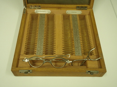
Trial Set of Lenses, unknown, 1905 (estimated)
This case only includes spherical lenses and has no cylindrical lenses for correction of astigmatism. The lenses have no rims, which was unusual after 1900. The set appears to have had very little use as it is in excellent condition.This is a late example of a trial case comprising only spherical lenses. The trial frame is a very rare type.Small timber cased trial set of spherical lenses only. No rims on lenses. Case labelled with lens powers in dioptres and inches. Trial frame included of unusual design:each eye rim has a sprung top cover to secure lens in place. Nickel alloy. Fixed bridge stamped 62, tapered sides with loop ends. Also a lens handling tool (nickel alloy) to position a lens in front of patient's eye.Lens powers labelled in inches and dioptres. Trial frame bridge stamped '62'.optometry, lenses, refraction, trial case, trial set -
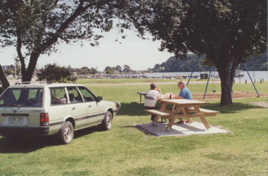 Lakes Entrance Historical Society
Photograph - Eastern boat ramp Lakes Entrance Victoria, LE Tidy Town Committee, 1994 c
Eastern boat ramp on North Arm, old concrete bridge over North Arm in distance Lakes Entrance VictoriaColour photograph of picnic area adjacent to Eastern boat ramp on North Arm, old concrete bridge over North Arm in distance Lakes Entrance Victoriarecreational facilities, boat ramp, gippsland lakes, parks -
 Clunes Museum
Photograph, BAWDEN PHOTOGRAPHER, CIRCA 1890
TULLAROOP CREEK FROM "ROCKS" NEAR SITE OF PORT PHILLIP MINE. ABOUT 1890 - NOTE GOVERNMENT BRIDGE IN DISTANCE. THIS WAS REBUILT IN STRAIGHT STEEL GIRDERS IN 1896.ORIGINAL SEPIA PHOTOGRAPH OF TULLAROOP CREEK, IN FOREGROUND VIEWS OF CLUNES TOWNSHIP. TWO MILE HILL IN LEFT FAR DISTANCE. (SUSPENSION BRIDGE IN FOREGROUND)local history, photography, bridges - buildings and landscape of clunes -
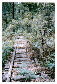 Marysville & District Historical Society
Photograph (item) - Colour photograph, 01-1964
A colour photograph of the timber tramway bridge along the Michaeldene Walking Track near Marysville in Victoria.A colour photograph of the timber tramway bridge along the Michaeldene Walking Track near Marysville in Victoria. The Michaeldene Trail to Taggerty River Lookout is a 4.3 kilometer lightly trafficked loop trail located near Marysville, Victoria. The track is one of several walking tracks located in and around Marysville in Victoria.MARYSVILLE JANUARY 1964timber tramway, michaeldene walking track, marysville, victoria, walking track -
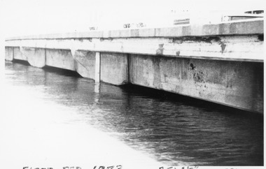 Charlton Golden Grains Museum Inc
Photograph, Charlton Tribune, B/W Photograph of 1973 Flooded Avoca River, February 1973
1973 Flooded Avoca River in Charlton Victoria at the Paterson Bridge. Water Level 25ft 1 1/2 inches - all local waterunframed 1973 Flooded Avoca River in Charlton Victoria at the Paterson Bridge. Water Level 25ft 1 1/2 inches - all local waterflood charlton victoria, james paterson bridge, local water -
Clunes Museum
Postcard
A PICTURE OF APOLLO BAYlocal history, document, card, greeting card -
 Lakes Entrance Historical Society
Photograph - Bullock Island Lakes Entrance, M Holding, 1988 c
Kalimna Heights showing development on Bullock Island including Pecks Factory. The Club Spit of dredged sand is acquiring vegetation. April Hamer dredge moored at Port Jetty, new bridge in place Lakes Entrance VictoriaAlso two colour photographs showing dumped sand on Bullock Island taken from Princes Highway lower parking bay June 2000. Donor L P Newspaper number 04209.1 size 10 x 15 cm and 04209.2 size 10 x 15 cm|Two colour photographs of Gippsland Ports Facilities taken from waterway numbers 04208.3 and 04208.4 size 10 x 15 cmColour photograph taken from Kalimna Heights showing development on Bullock Island including Pecks Factory. The Club Spit of dredged sand is acquiring vegetation. April Hamer dredge moored at Port Jetty, new bridge in place Lakes Entrance Victoriaislands, waterways, gippsland lakes -
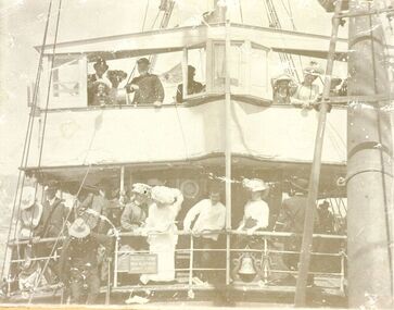 Port Fairy Historical Society Museum and Archives
Photograph
S.s.Casino 1910. The people on the decks are tourists coming from Terang and surrounding areas to spend the day at the seaside. The steamer S.S.CASINO was much loved by the whole Port Fairy community- with the possible exception of some of the fishermen whose boats she ran down! Transport of the large quantities of wool, potatoes, onions, grain, sheep, cattle and other produce grown on the rich lands of the Western District Belfast was served by a plethora of shipping, both sail and steam, but only one of the steamers then in the regular trade (S.S. DAWN) would ever be able to get up the river and reap the cost savings of loading against a wharf. It was not unusual for four steamers to be anchored in the bay at once and for seven or eight different steamers to call during a week. A number of inter-colonial steamers also called to pick up produce for delivery to Melbourne, Sydney and Adelaide. Production in the Western District was increasing and virtually all of that production had to go through one of the western ports in order to reach markets. By 1882 a meeting 15ft. March, 1882, in the office of auctioneer, J.B. HoIden in Cox Street took action and it was unanimously resolved - that the Belfast & Koroit Steamship Company be formed with a capital of £20,000 in 10,000 shares of £2 each". A number of steamers were offered by letter to the fledgling company, including the new and almost sister ships, CASINO and HELEN NICHOLL. The CASINO was on her delivery voyage from England was due to arrive in Warrnambool to load potatoes for Sydney and, initially, arrangements were made for her to call into Port Fairy for inspection by the BKNS Co directors. She eventually proceeded direct to Warrnambool and the Directors inspected her there. Without hesitation they purchased her even though they had to raise a large bank loan to do so. The CASINO arrived in Port Fairy on Saturday, 29th. July, 1882, steaming triumphantly up the Moyne River, and was greeted by crowds, many of whom had driven in from the surrounding countryside, which gave her “loud ringing English cheers". By 1884 the CASINO could not carry all the cargoes available to her and in December of that year the company purchased the new steamer BELLINGER to provide additional capacity. She helped to open up the intermediate ports of Lorne, Apollo Bay and Port Campbell, but the BELLINGER was not really suitable for the trade and she was sold in 1887, leaving the CASINO to operate alone -as she was to do for almost all of the next 45 years. The opening of the railway in 1890 decreased the cargo available to the steamers and the economic depression of the early 1890's worsened the situation. The weak soon began to fall by the wayside and when the Portland & Belfast SN Co. decided to go into liquidation in April 1895, the Belfast & Koroit Company bought the Portland Company's steamer DAWN on advantageous terms, a substantial part of the payment being in BKSN Co shares. The BKNS Co and the Howard Smith Line came into direct head to head competition and nearly forced the BKNS Co out of existence. Cargo dropped to such an extent that in 1899, they reached agreement that only one ship would run and that the ship which ran would pay a weekly amount to the competitor to stay out of the trade. This controlled service ceased in1909, and competition intensified when Howard Smith placed the newly built, larger steamer EUMERALLA on the run. The BKNS Co survived this competition and even prospered during it partly by extending on a more regular basis, the CASINO'S voyages to South Australian ports Port Macdonnell, Kingston, Beachport, Robe and, on occasions Adelaide. There were setbacks when, on 20 October 1924, CASINO went ashore at the Kennett River, near Apollo Bay, and again, in February l929, when she struck a submerged object at Warrnambool and had to be beached. The railways placed great competitive pressure on the small steamship company and this pressure was intensified when the Great Depression slashed the market for Western District produce, BKNS Co struggled on, paying dividends in most years, and the company planned a big celebration for the CASINO'S fiftieth anniversary in the trade on 29th July, 1932. Disaster struck soon after 9 o'clock on the morning of Sunday I0 July, 1932 when the CASINO was lost at Apollo Bay together with the lives of 10 crew members. Black and white photograph of tourists crowded on the decks of s.s.Casino during a sail around the bay for Terang dayship, boat, sea, river, s.s.casino 1910, transport, 1910, wool, onions, grain, sheep, cattle, steam, terang day -
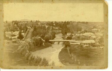
 Orbost & District Historical Society
black and photograph / postcard, 1.4.1908
This postcard was sent to Annie Gilbert (Mrs John Gilbert) of Tullagoota, Orbost. It was written by "Grace", probably her sister, Grace Cameron Annie Gilbert was the daughter of John Cameron who selected the first land on the Snowy River flats. This is a photograph of the original Orbost / Snowy River Bridge , a suspension bridge which opened in 1893. It has been taken when the Snowy River was in flood. It is similar to other photographs held in The State Library, Victoria. The Snowy River Mail and Tambo and Croajingolong Gazette Sat 12 Aug 1893 records the opening of this bridge as "the most important public event that has yet been commemorated in Eastern ......The Messrs McLeod, with whom the first settlement of this district is generally associated, took up their residence on the eastern bank of the Snowy River about the year 1841 or 42. The late Mr W. Roadknight and Mr T. T. Stirling took possession of the territory on the western side of the Snowy about 35 years ago. During the occupation of the country by cattle owners, very little progress was made in the way of roads and bridges, and except to the hardy and lexperienced bushman, it might have been generally regarded as inaccessible. About the year 1877, however, the late Mr James Robertson eldest son of Mr James Robertson, of Lochend farm, selected land now occupied by his father, about four miles from Orbost on the west bank of the river, Mr John Cameron visited the. district shortly after a .tour of inspection and returned later with his brothers, James and Alick Gameron, but found that during their absence Mr Ernest Watt had found his way on the scene and pegged out a selection, thus anticipating the advent of the Camerons by about 12 hours. We understand that a Mr Kidd, who selected the property now occupied by Mr W. J. Ross, at Pumpkin Point, was one of the earliest batch of settlers.........."This item is associated with Annie Gilbert (nee Cameron) reported to have been the first white girl to be born in Orbost. It is a pictorial record of the suspension bridge over the Snowy River which has since been replaced twice.A faded black / white postcard of a bridge across a river. There are cattle in the river and the banks are tree-covered.on back - a hand-written letter addressed to Mrs J. Gilbert Tullagoota Orbost.cameron-annie suspension-bridge-orbost snowy-river-orbost -
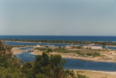
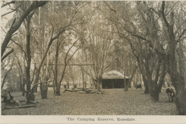 Lakes Entrance Historical Society
Postcard, Camping Reserve Rosedale, 1940 c
Also a black and white postcard of highway bridge over the Latrobe River Rosedale 05412.1 9 x 14 cmBlack and white postcard of camping reserve showing picnic shelter and two fire places set in timbered area and glimpses of highway bridge through trees Rosedale VictoriaThe Camping Reserve Rosedalecamping, bridges -
 Orbost & District Historical Society
book, Snowy River Mail as "Mail" Print, Princes Freeway Orbost Section, 2117.1 : 1976 2117.2 : 4.9.2013
The Snowy River Bridge, Princes Freeway, Orbost, Victoria was opened by the Hon. J A Rafferty, Minister for Transport, 25 November 1976. ‘The bridge was built at a cost of A$2.4 million and is the first of four bridges to be built as part of the 8.4 kilometre freeway bypass of Orbost. Construction of the bridges commenced in January 1975, with an expectation to open the bridge across the Snowy River as soon as possible. Less than two years later, on 25 November 1976, the bridge across the Snowy River was opened to traffic, allowing the old bridge to be demolished. The remainder of the Orbost Bypass, both the floodplain crossings and the eastern section around the township itself, was declared ‘Princes Freeway’. The newspaper article was written by David Jellie as part of the centenary celebrations of Vic Roads/Country Roads on 4.9.2013. David Jellie was the project engineer for the Snowy River Crossing Project.This book and article contain historical information and details about the construction of the bridges on the Orbost section of the Princes Freeway.2117.1 isaA thin paperbook book which contains a map, history and construction details of the Princes Freeway at Orbost. It has a program for the opening ceremony of the snowy River Bridge in 1976. 2117.2 is an article from the snowy River Mail on the history of the highway. It is dated 4.9.2013.In pencil - 20csnowy-river-bridge jellie-david princes-freeway-orbost -
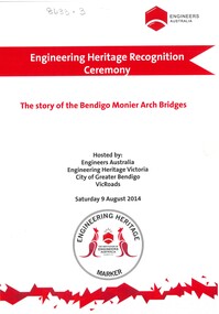 Bendigo Historical Society Inc.
Booklet - Engineering Heritage Recognition Ceremony
In 1867, Frenchman Joseph Monier patented the use of metal reinforced concrete for use in horticultural troughs. Francois Hennebique expanded this idea into a general construction technique including for the construction of bridges bridges with the first bridge built in 1875. In Victoria, Monash and Anderson, representatives of the Australian patent holders and later Victorian patent holders. The Bendigo Monier Bridges were built between 1901 and 1902. Monash's contribution was not in the actual technology but in the promotion and defence of the new technology that was faced by much doubt and scepticism.Ten page booklet with a red and white cardboard cover produced for the Engineering Heritage Recognition Ceremony held on 9th August 2014. Includes the story of the Monier Arched Bridges in Bendigo. Includes B&W and coloured photographs. Produced by Engineers Australia.monier, monier bridges, sir john monash, joshua anderson, engineering -
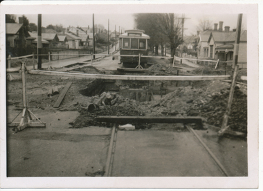 Ballarat Tramway Museum
Photograph - Digital image, Wal Jack, 12/06/1955 12:00:00 AM
Yields information the reconstruction of the Canadian Creek Bridge in 1955.Digital image from the Wal Jack Ballarat Album of No. 32 at Canadian Creek bridge in Barkly St, Mt Pleasant during the reconstruction of the bridge. Photo dated 12-6-55 and shows the reconstruction work in progress. Tram was isolated to enable the service in Barkly St during the reconstruction of the Canadian Creek bridge during June-July 1955, see Reg Item 5155, 5157 as well and 5301, 5302 and 5305. See image i2 for rear of photograph. See image i3 for hi res scan of print. See image i4 for hi res scan of negativeOn rear in ink "SEC Ballarat No. 32 in Barkly St west of creek - old bridge pulled down 12-6-55." In top right hand corner is Wal Jack stamp with number T177 written in.trams, tramways, mt pleasant, canadian creek, barkly st, tram 32 -
 Port Melbourne Historical & Preservation Society
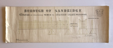
Plan, Charles Clay, Borough Surveyor, Elevation of Proposed Fence to Station Place Reserve, c. 1881
Although undated, the plan is probably from 1880-81. The plan is signed by Charles CLAY, Fred WILLIAMS and Witney Henry BATES. Charles CLAY was the Borough Surveyor from 1860 to 1884. Fred WILLIAMS was a Councillor 1875 to 1886 and served as Mayor, 1880-81. It is not known who Witney Henry BATES was. A note in pencil, probably added later, indicates the fence was between Graham and Bridge Streets.Undated Borough of Sandridge hand-drawn plan for a proposed picket fence at Station Place Reserve.'between Graham and Bridge Streets' handwritten in pencil below and to the right of the main title.local government - borough of sandridge, engineering - fences, charles clay, witney henry bates, frederick williams -
Port Melbourne Historical & Preservation Society
Document - Memoir of 'The Flat' between Lt Bay and Lt Dow Streets, Port Melbourne, 1936
Memoir written by Ed Whiting about "The Flat", Bay St and Litle Bay St, during the 1930s. social activities, engineering - roads streets lanes and footpaths, domestic life, built environment, edwin whiting, violet wood, thelma trembeth, lionel wood, micky clezishen, alf wood, leo 'doc' wood -
 Melbourne Legacy
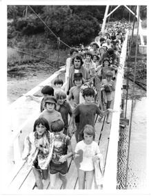
Photograph - Junior legatee outing, Somers Camp 1979, 01/1979
A photo of a large group of children crossing a bridge enroute to the beach. It came from an envelope with other camp photos. The Legacy envelope was marked "P6 Junior Legatee Camps and Hols" in red pen, and dated Jan 1977 in pencil. The contents will be items 00418 to 00425. Melbourne Legacy provides camps for junior legatees. The camps gave the children an opportunity of a summer beach holiday with other Legacy children. It started with outings to the property of Legacy founder, Legatee Stan Savige, who had a place in Balnarring. close to the beach. Permanent camp buildings were built in 1930. In 1930 Lord Somers (Governor of Victoria) also started a camp at a nearby property and the area was renamed Somers. Legacy Somers Camps continued intermittently at Stan's property until it was decided in 1951 to make other arrangements for holidays. A record of Junior Legatee camps.Black and white photo of children crossing a bridge at the beach.Handwritten on back "Jan 1979" in blue pen. Stamped "The property of Melbourne Legacy" in purple ink. Stamped "Copyright The Herald and Weekly Times" in blue ink. junior legatee outing, bridges, beach, somers camp -
 Orbost & District Historical Society
black and white photographs, 20th century
These photographs are probably of bridges on the East Gippsland railway line. 3162.2 is possibly Hospital Creek and 3162.3 possibly Burn Road Newmerella. The Orbost-Bairnsdale railway initially played a crucial role in developing agricultural industries in Gippsland as well as tourism. It opened in 1916 and operated until 1987, principally carrying timber and farming produce. In the early days of the railway's operation dedicated passenger trains ran but these ceased by the 1930s. The line was completely closed to freightage in 1987.The track infrastructure was dismantled in 1994 and has been redeveloped as the East Gippsland Rail Trail.These photographs are associated with the history of the Orbost-Bairnsdale railway line and therefore reflects the role that the rail line played in the social and economic history of Orbost. Three black / white photographs of railway bridges. 3162.1 has a steam train on the bridge. 3162.3 shows three men on the right working at clearing vegetation. 3162.3 has been taken from a height.orbost-bairnsdale-railway east-gippsland-railway bridges-railway -
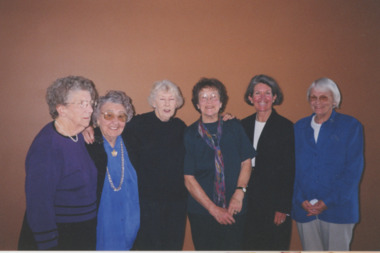 Lakes Entrance Historical Society
Photograph - Bridge Club Champions ,Lakes Entrance Victoria, Lakes Post Newspaper, 1/10/2001 12:00:00 AM
Bridge Club Champions Ros Creaser Dorothy Bald Pat White Betty Alexander Trish Brown and Dot Lawrence Lakes Entrance VictoriaColour photograph of Bridge Club Champions Ros Creaser Dorothy Bald Pat White Betty Alexander Trish Brown and Dot Lawrence Lakes Entrance Victoriacelebrations, clubs, cards, recreation -
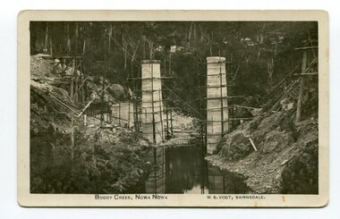 Orbost & District Historical Society
photograph / postcard, early 20th century
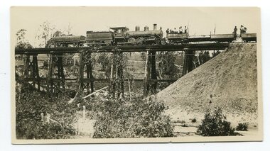
Boggy Creek Bridge was built in 1916 as part of the Bairnsdale to Orbost extension to the main Gippsland Railway, and is situated in the middle of the township of Nowa Nowa, crossing a steep-sided and well-timbered creek-valley. This section of the line closed in 1987.This item is a pictorial record of the construction of the Boggy Creek railway bridge on the East Gippsland line. This bridge plays a major part in the identity and history of the town of Nowa Nowa, since Boggy Creek’s steep sided valley divides the township into two components. A black / white photograph on a postcard showing the construction of a railway bridge across a creek. The end pylons are evident and there is scaffolding on both sides of the creek. Two copies of a black / white photograph showing the construction of a railway bridge across a cree. The end pylons are evident and there is scaffolding on both sides of the creek. There is a steam train on the rail track.on front of postcard - caption - " Boggy Creek, Nowa Nowa, W.S. Vogt, Bairnsdale"boggy-creek-bridge vogt-w.s. railway-bridges east-gippsland-railway railway-construction train -
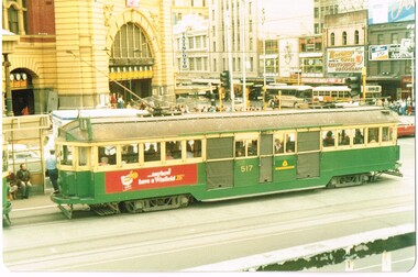 Melbourne Tram Museum
Photograph - Set of 4 Colour Print/s, c1985
Set of four colour prints of trams in Flinders St taken from the Princes Bridge station building deck - 14-5-1985, by an unknown photographer. All printed on Fujicolor Paper with rounded edges. .1 - W2 517 on route 8 northbound in Swanston St with Flinders St station entrance in background. Has a Winfield cigarette advertisement on the side. .2 - W2 453 on route 8, southbound about to cross Princes Bridge with the Anniversary Arch 1984-85 in the background. .3 - W2 605 and W6 994 northbound in Swanston St, with the Flinders St Station concourse buildings in the background. Has a "new black & white 30's" cigarette, Invicta and King Gee work trousers advertisements. .4 - W5 831, south bound on route 72 at the station stop. Has a Reflex copying paper advert on the side panel..3 has in ink on the rear - "W6 994, W2 605 W5 ? Princes Bridge 14.5.85"trams, tramways, flinders st station, princes bridge, swanston st, tram 517, tram 453, tram 994, tram 605, tram 831 -
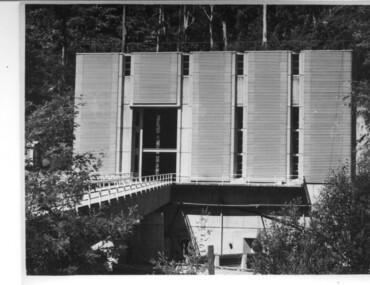 Kiewa Valley Historical Society
Photograph of Clover Power Station, No. 3 Power Station, after May 1944
In July, 1941 work commenced on the site of the power station with the building of a coffer dam and excavation for the power station building and machine foundations followed. Work proceeded, and the access bridge, transformer foundations and transfer track were completed in April, 1943 and the power station building in May, 1943. Installation of the machines was then proceeded with and No. 1 machine was run for the first time in June 1944. No. 2 machine was completed in April, 1944 and placed in service in May.A pictorial record for the State Electricity Commission of the first Power Station commissioned in the Kiewa Hydro Electric Scheme.Black and white photograph of the bridge and entrance to No. 3 Power Station (Clover Power Station).Handwritten on back of photograph in blue ink "No. 3 Power Station".clover, power station, machine, kiewa scheme