Showing 10531 items
matching land
-
 City of Kingston
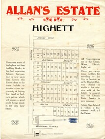
Pamphlet - Colour, Allan's Estate Highett, 1930s
Sales plan for land in the suburb of Highett, bounded by Spring Road, Highett Road and Worthing Terrace.The developing urban area of Highett within the City of Kingston. This land sale pamphlet illustrates the subdivision of land within the municipality and the changing demographic of the district as new houses are constructed.Colour pamphlet advertising Allan's Estate, Highett. Incorporates a map of the estate bordered by Spring Road, Highett Road and Worthing Terrace.Handwritten in grey pencil on reverse: Allan's Estate / Highett Crossed out in blue pencil on front: Name and address of what appears to be a solicitorhighett, land sales, estate -
 City of Kingston
Pamphlet - Black and white, Stott & Burke, Highland Estate Bentleigh, c.1915
Sales plan for land in the suburb of Bentleigh, along Collins and Ross Streets, bounded by Jasper Road.The developing urban area of Bentleigh within the City of Kingston. This land sale pamphlet illustrates the subdivision of land within the municipality and the changing demographic of the district as new houses are constructed.Black and white pamphlet advertising for private sale the Highland Estate, Bentleigh. Incorporates a map of the estate between Collins St and Ross St, bordered by Japser Road. Handwritten in grey pencil on map: additional subdivisions numbered 15-19 drawn along Ross St Handwritten in grey pencil on map: indecipherable annotations to subdivisions 1, 3 and 14land sales, bentleigh, estate -
 Greensborough Historical Society
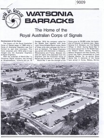
Article - Article, Newsletter, Watsonia Barracks: the home of the Royal Australian Corp of Signals
A short history of the Royal Australian Corps of Signals at Watsonia Barracks, including background history of the land.Printed article with black and white photos, 3 pageswatsonia army barracks, simpson army barracks -
 Kew Historical Society Inc
Plan, Melbourne & Metropolitan Board of Works : Borough of Kew : Detail Plan No.1581, 1904
The Melbourne and Metropolitan Board of Works (MMBW) plans were produced from the 1890s to the 1950s. They were crucial to the design and development of Melbourne's sewerage and drainage system. The plans, at a scale of 40 feet to 1 inch (1:480), provide a detailed historical record of Melbourne streetscapes and environmental features. Each plan covers one or two street blocks (roughly six streets), showing details of buildings, including garden layouts and ownership boundaries, and features such as laneways, drains, bridges, parks, municipal boundaries and other prominent landmarks as they existed at the time each plan was produced. (Source: State Library of Victoria)This plan forms part of a large group of MMBW plans and maps that was donated to the Society by the Mr Poulter, City Engineer of the City of Kew in 1989. Within this collection, thirty-five hand-coloured plans, backed with linen, are of statewide significance as they include annotations that provide details of construction materials used in buildings in the first decade of the 20th century as well as additional information about land ownership and usage. The copies in the Public Record Office Victoria and the State Library of Victoria are monochrome versions which do not denote building materials so that the maps in this collection are invaluable and unique tools for researchers and heritage consultants. A number of the plans are not held in the collection of the State Library of Victoria so they have the additional attribute of rarity.Original survey plan, issued by the MMBW to a contractor with responsibility for constructing sewers in the area identified on the plan within the Borough of Kew. The plan was at some stage hand-coloured, possibly by the contractor, but more likely by officers working in the Engineering Department of the Borough and later Town, then City of Kew. The hand-coloured sections of buildings on the plan were used to denote masonry or brick constructions (pink), weatherboard constructions (yellow), and public buildings (grey). The streets and built structures in this plan were surveyed in 1903 and released to contractors in 1904. In addition to the designation of building types by colour, the plan includes detailed descriptions of land use and ownership. While many buildings remain from this period, a number of the buildings represented have been demolished including the original Kew Town Hall, and the Congregational and Roman Catholic churches in Walpole Street. While the mansion ‘Illapa’ in Princess Street is still extant – now part of ‘Rylands’ – the neighbouring mansion ‘Elsmere’ was demolished some decades ago. Rivalling Illapa and Elsmere in size were two mansions in Walpole Street, one named on the plan as ‘Gnarlbine’. Over time, Kew Junction and the south side of High Street have been reconfigured and widened, so that the commercial buildings on the corner of Princess and High Street no longer exist. A surprising feature of this part of central Kew to the northwest of Kew Junction is the amount of vacant land. In a number of cases, this land is noted by the contractor as used for vegetable gardens.melbourne and metropolitan board of works, detail plans, maps - borough of kew, mmbw 1581, cartography -
 Orbost & District Historical Society
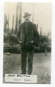
black and white photograph, before 1921
Jack Bruton selected land at Murrungowar and held the licence for the Murrungowar Hotel. He later became a butcher in Orbost. He was on the first Orbost Golf Club committee in 1906. .The golf club was established in 1906 it was originally formed as the Snowy River Golf Club and played on private land near the banks of the Snowy River just to the south of town.This is a pictorial record of Jack Bruton, one of the early settlers of Murrungowar, a former township east of Orbost.A black / white photograph of a man standing outside alone with his hands in his pocket. He has a moustache and has a pipe in his mouth. He is wearing a hat.on front - "Jack Bruton died 1921" on back - "Mr Jack Bruton, Murrungower Hotel"bruton-jack murrungowar-hotel orbost-golf-club -
 Greensborough Historical Society
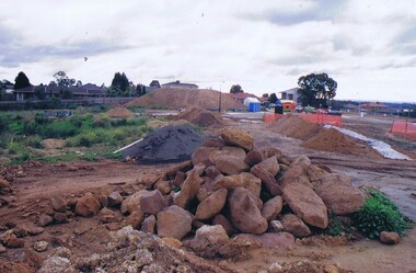
Photograph - Digital image, Frank Solomon, Development of pig farm to residential blocks, 1, 02/08/2009
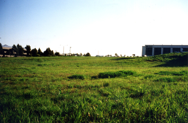
A view of the redevelopment of the pig farm in Weidlich Road Greensborough, owned by Werner Hanusch. The land was used as a pig farm and quarry from 1954 and this photo shows early stages of the land being subdivided into the Evelyn Way estate. This project of fifty, one double storey, dwellings was commenced on 2/8/2009 and completed on 6/2/2011.An example of the changing land use in Greensborough, from farming to residential.Digital copy of colour photographwerner otto fritz hanusch, pig farm st helena, weidlich road greensborough, one evelyn way greensborough -
 Greensborough Historical Society
Photograph - Digital image, Frank Solomon, Development of pig farm to residential blocks, 2, 02/08/2009
A view of the redevelopment of the pig farm in Weidlich Road Greensborough, owned by Werner Hanusch. The land was used as a pig farm and quarry from 1954 and this photo shows early stages of the land being subdivided into the Evelyn Way estate. This project of fifty, one double storey, dwellings was commenced on 2/8/2009 and completed on 6/2/2011.An example of the changing land use in Greensborough, from farming to residential.Digital copy of colour photographwerner otto fritz hanusch, pig farm st helena, weidlich road greensborough, one evelyn way greensborough -
 Greensborough Historical Society
Photograph - Digital image, Frank Solomon, Development of pig farm to residential blocks, 3, 02/08/2009
A view of the redevelopment of the pig farm in Weidlich Road Greensborough, owned by Werner Hanusch. The land was used as a pig farm and quarry from 1954 and this photo shows early stages of the land being subdivided into the Evelyn Way estate. This project of fifty, one double storey, dwellings was commenced on 2/8/2009 and completed on 6/2/2011.An example of the changing land use in Greensborough, from farming to residential.Digital copy of colour photographwerner otto fritz hanusch, pig farm st helena, weidlich road greensborough, one evelyn way greensborough -
 Greensborough Historical Society
Photograph - Digital image, Frank Solomon, Development of pig farm to residential blocks, 4, 02/08/2009
A view of the redevelopment of the pig farm in Weidlich Road Greensborough, owned by Werner Hanusch. The land was used as a pig farm and quarry from 1954 and this photo shows early stages of the land being subdivided into the Evelyn Way estate. This project of fifty, one double storey, dwellings was commenced on 2/8/2009 and completed on 6/2/2011.An example of the changing land use in Greensborough, from farming to residential.Digital copy of colour photographwerner otto fritz hanusch, pig farm st helena, weidlich road greensborough, one evelyn way greensborough -
 Greensborough Historical Society
Photograph - Digital image, Frank Solomon, Development of pig farm to residential blocks, 5, 02/08/2009
A view of the redevelopment of the pig farm in Weidlich Road Greensborough, owned by Werner Hanusch. The land was used as a pig farm and quarry from 1954 and this photo shows early stages of the land being subdivided into the Evelyn Way estate. This project of fifty, one double storey, dwellings was commenced on 2/8/2009 and completed on 6/2/2011.An example of the changing land use in Greensborough, from farming to residential.Digital copy of colour photographwerner otto fritz hanusch, pig farm st helena, weidlich road greensborough, one evelyn way greensborough -
 Whitehorse Historical Society Inc.
Photograph, Tally Ho Business Park
Tally Ho Business Park was developed by Land Lease, commencing in 1988, and then CGA Bryson from the late 1990's. It was completed in 2002. The land on which it stands was previously the site of the Tally Ho Boys Home. This home was run, from 1903-1986 by the Wesley Central Mission, which caters for boys from the slums. It closed in 1986.Coloured photograph of Tally Ho Business Park in the early stages, looking north towards Burwood Highway.tally ho business park east burwood -
 Melbourne Legacy
Document - Document, notes, Re. Hostel
Legatee Russell's assessment dated 16 November 1942 of a property owned by a Mr J. Trim at Sackville Street, Kew, in connection with the proposal to establish a Hostel. His main concern was that the property had too much land attached, and he discusses possible solutions before concluding that an alternative property with less land would be preferable.A record to the types of properties available at the time in relation to the needs of prospective children.Two typed foolscap sheets, carbon copies, two punched holes for filing.Signed by Legatee Eric Russell, Chairman Hostel Committee.residences, holmbush -
 Vision Australia
Model - Object, Tactile globe, 1950-1965 approx
Used to teach geographical information, this tactile globe was most likely produced by the RNIB and used at the RVIB Burwood School. Equator is raised and marked in black rubber. Topography land masses and meridians are tactically represented, and includes place names in Braille. A different shade of green is used to represent land masses, and major rivers are shown as well.Green plastic tactile globe with metal stand.Variouseducation aids and devices, rvib burwood school -
 Orbost & District Historical Society
map/poster, Victorian Government Printer, 22.4.1926
The Department of Crown Lands and Survey was originally established in 1857 as part of the Board of Land and Works. In 1964 it ceased to be controlled by the Board. The Department functioned for almost twenty more years before being combined with other Ministries to form the Department of Conservation, Forests and Land. It was responsible for the management of the State's Crown land and pastoral estates. This map was used by Don Mehlert after 1928. The VERMIN AND NOXIOUS WEEDS ACT 1928 was an Act to consolidate the Law relating relating to Vermin and Noxious Weeds. E. J. E. G. Pemberton who published this poster was Superintendent of Field Staff, Dept. of Lands and Survey. This map and posters are significant records of early settlement history in Murrangower, between Cabbage Tree and Orbost,A paper map of Murrangower showing settlement subdivisions. This is glued onto the back of four overlapping cloth poster of "Notices of Vermin Destruction". All print is black."DON MEHLERT" in black pen. Pike's block shaded in blue. School site marked in blue pencil. on poster "MURRANGOWAR" along side.map-murrangower poster-vermin-and-noxious-weeds murrangower-settlement -
 Shepparton RSL Sub Branch
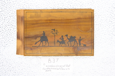
Postcard and Pressed Flowers Book, Wooden Covered Postcard and Pressed Flower Book from Jerusalem 1941, approximately 1941
souvenirs from the middle Eastern Countries during WW2A wooden covered book; 10 pages with post card and on left hand side and pressed flower arrangements on opposite page. Pages separated by translucent tissue paperBlack inked drawing depicting camels , cameleers and palm tree on front cover; central back wooden cover 'Jerusalem' printed Inside cover in handwriting " To Mother From Dad 18th January 1941" Book title " Flowers and Views of the Holy Land - Fleurs et vues de la Terre Sainte" postcard pressed flower book -
 The Beechworth Burke Museum Research Collection
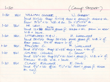
Card (Series) - Index Card, George Tibbits, Camp Street, Beechworth, 1976
George Tibbits, University of Melbourne. Faculty of Architecture, Building and Town & Regional PlanningIndex system that support the research for Beechworth : historical reconstruction / [by] George Tibbits ... [et al]Arranged by street names of BeechworthEach index card includes: street name and number of property, image of property, allotment and section number, property owners and dates of ownership, description of the property according to rate records, property floor plan with dimensions.beechworth, george tibbitsbeechworth, george tibbits -
 Greensborough Historical Society
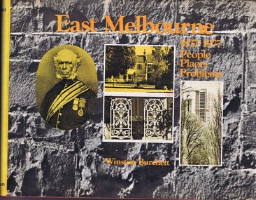
Book, Craftsmen Press, East Melbourne: 1837-1977: people, places, problems, 1977
A history of early development and more recent redevelopment in East Melbourne, from a town planning perspective.177 p., illus., maps.non-fictionA history of early development and more recent redevelopment in East Melbourne, from a town planning perspective.east melbourne, town planning, melbourne -
 Greensborough Historical Society
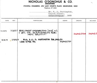
Legal record - Account, Nicholas O'Donohue & Co, Nicholas O'Donohue & Co to Partington 1971, 12/07/1971
A solicitor's account to Alan Partington following a land transaction with Development Underwriting Vic. P/L in 1971. Part of many land deals made by the Partington family in the sale of the original Greensborough farmland.Solicitor's account, black text on white paperalan partington, william alan partington, partington family, land deals greensborough, nullarbor -
 City of Moorabbin Historical Society (Operating the Box Cottage Museum)
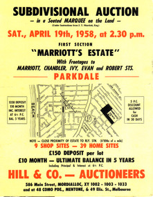
Flyer - Marriott's Estate, Parkdale, 1958
After WWII there was a decline in the market gardens in the City of Moorabbin, as the value of the land was more profitable than the crops.Example of the progress of the Municipality of MoorabbinPhotocopy of advertising flyer for auction of real estate sales - plan of building blocks for saleMarriott's Estate, Parkdale - Auction 19 April 1958 - 39 home sites - 9 shop sitesmarriott street, chandler st, ivy st, robert st, parkdale, real estate, auction -
 City of Moorabbin Historical Society (Operating the Box Cottage Museum)
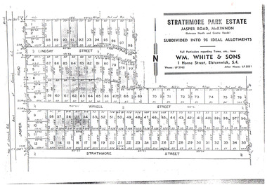
Flyer - Strathmore Park Estate, Jasper Road McKinnon, 1942
After WWII there was a decline in the market gardens in the City of Moorabbin, as the value of the land was more profitable than the crops.Example of the progress of the Municipality of MoorabbinPhotocopy of advertising flyer for auction of real estate sales - plan of building blocks for saleStrathmore Park Estate, Jasper Road Bentleigh Subdivided into 98 Ideal Allotmentsstrathmore street, wavell street, lindsay street, jasper road, mckinnon, bentleigh, real estate, auction -
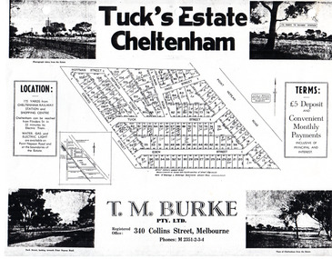 City of Moorabbin Historical Society (Operating the Box Cottage Museum)
Flyer - Tuck's Estate, Cheltenham, 1940
After WWII there was a decline in the market gardens in the City of Moorabbin, as the value of the land was more profitable than the crops.Example of the progress of the Municipality of MoorabbinPhotocopy of advertising flyer for sale of real estate sales - plan of building blocks for saleTuck's Estate Cheltenham - plan of subdivisionedward street, point nepean road, eden street, tuck street, hoffman street, elman road, page street, cheltenham, real estates, auction, tuck -
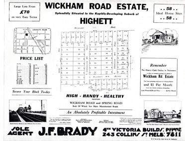 City of Moorabbin Historical Society (Operating the Box Cottage Museum)
Flyer - Wickham Road Estate, Highett, 1940
After WWII there was a decline in the market gardens in the City of Moorabbin, as the value of the land was more profitable than the crops.Example of the progress of the Municipality of MoorabbinAdvertising flyer for auction of real estate sales - plan of building blocks for saleWickham Road Estate, Highett 58 Home siteshillcrest ave, wickham road, spring road, grandview road, maroona road, highett, land sales, real estate -
 Port Melbourne Historical & Preservation Society
Document - purchase and building costs SSB, Public Records Office Victoria (PROV), 1886 - 1982
The State Savings Bank building was constructed c1891. This note outlines land purchase costa and building costsCOPYRIGHT Public records Office Victoria .03 - 1886 document built environment - commercial, business and traders, state savings bank of victoria -
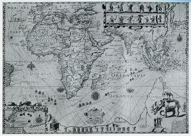 Ballarat Heritage Services
Map, Plancius's Map (Amsterdam), 1594, 1594
Copy of a Dutch map published in Amsterdam. showing a large stretch of outhern land called Terra sustralis Copy of a map from 'A Short HIstory of Australia' by Ernest Scott.map, plascius, placius's map, terra australis, dutch map -
 Ballarat Heritage Services
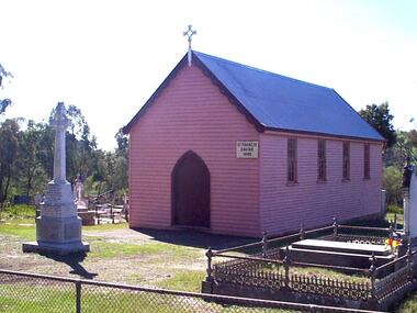
Photograph - Photograph - Colour, Clare Gervasoni, St Francis Xavier Chapel, Eganstown, 1999, 28/09/1999
The St Francis Xavier Chapel and Catholic Cemetery was established on land donated vby squatter John Egan.Three photographs of St Francis Xavier Chapel, the chapel in the Eganstown Catholic Cemetery. The grave stone at the front of the church is for John Egan. st francis xavier chapel, eganstown, 1999, eganstown catholic cemetery, eganstown, church, chapel, cemetery, john egan -
 Lakes Entrance Regional Historical Society (operating as Lakes Entrance History Centre & Museum)
Postcard, 1955c
Kalimna Hotel built 1884 to 1885 by Thomas Laughton on land previously leased by Peter Egan FishermanTinted postcard of Kalimna Hotel showing a Pioneer Tourist Coach parked at the front with glimpse of Beer Garden on Western side of main building, Hotel Road Kalimna Victoriabusinesses -
Whittlesea Historical Society Inc.
Document - Receipt, Yan Yean Public Cemetery, 1892
Yan Yean Public Cemetery receipt for Allotment of Land for the deceased Jas H. Lockwood. Dated 1892.A small paper receipt, 1 of 2 items pinned togetherSigned by James Ryan Jnr, Secretary.yan yean cemetery, james h lockwood -
 Sunbury Family History and Heritage Society Inc.
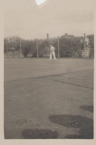
Photograph, c 1930s
The man was photographed playing tennis on the tennis courts that were sited on railway land in Evans Street Sunbury. A small snapshot of a man on a tennis court.tennis, tennis courts -
 Tarnagulla History Archive
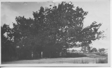
Photograph: Oak Tree, Llanelly, 1922
Not clear whether Annie Heffernan is the photographer or owner of the land where tree was situated. Donald Clark Collection. A monochrome photograph of a large oak tree in Llanelly, Victoria. Accompanied by a poem by John Hurford typed on a piece of paper. Title of poem is 'The Oak'. Dated 12/02/1922. The poem is catalogued separately.Written on reverse: 'Oak Tree Annie Heffernan Llanelly 1922'.llanelly, trees, tree -
 City of Kingston
Pamphlet - Black and white, J. F. Brady, The Hill Estate, Highett, c. 1905
Sales plan for land in the suburb of Highett, bounded by Sandford Street, Turner Street and Point Nepean RoadThe developing urban area of Highett within the City of Kingston. This land sale pamphlet illustrates the subdivision of land within the municipality and the changing demographic of the district as new houses are constructed close to infrastructure.Black and white pamphlet advertising for sale the Hill Estate, Highett. Incorporates a map of the estate bordered by Sandford Street, Turner Street and Point Nepean Road.Handwritten in grey pencil on reverse: The Hillland sales, highett, estate