Showing 446 items
matching slab
-
 Mt Dandenong & District Historical Society Inc.
Photograph, Looking Down Falls Road
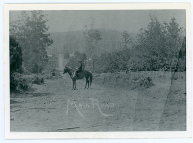
Edward John Price was a son of early settler Edward Joseph Price. Edward Joseph was the first settler in the Village Settlement when he took out Lot 1, Section 1. He built a small home of slabs and brought his family up in 1896. From the outset the Price family ran a store from their home.This picture, taken 1914, shows Edward John Price on his pony delivering papers from his parent's newsagency that was opposite 'Mountjoy' guesthouse on Ridge Road. He was taking them to Lily Badenhop's post office in Blythe's Road. The section of road he is on was called Main Road and is now Falls Road.Black and white photograph showing a man on horseback in the centre of an unmade road that is running into the distance.Trees, a fence and houses can be seen with hills in the background. Reverse of photograph has handwritten description by John Lundy-Clarke.On Front MAIN ROAD On Reverse Looking down Falls Road then the main road in 1914. Before Frank Craig built The Fron (1918). Dunbar’s house Halcyon on left of road. The hall on its right with Keogh’s sheds showing further in the trees. The horseman is Edward John Price who delivered the daily papers to Lil Badenhop’s shop. The bag he carried them in can be seen hanging from the saddle pommel. The first road formation can be seen on the bank to the right. The road seen was constructed 1905 by Bill McGivern.edward john price, edward joseph price, lily badenhop, post office, falls road, main road, mountjoy, frank craig, bill mcgivern, dunbar, halcyon, keogh, farndons hall -
 Mt Dandenong & District Historical Society Inc.
Photograph, Edward Joseph Price and Grandson
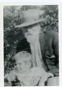
John Lundy-Clarke grew up in the Kalorama/Mt Dandenong area and later in life (1972-74) began to write a comprehensive history of the district working from an original settlement map in an effort to cover all areas. Edward Joseph Price took out Lot 1, Section 1 of the Village Settlement and became the first settler, moving his family up into a slab hut on his selection in 1896. Edward Joseph had two sons (Charles Joseph and Edward John) and a daughter (Kathleen Nathalie Caroline). Edward Joseph Price is holding his grandson Teddie, son of Edward John Price. Photo taken 1936.Black and white photograph in close up showing an old man with a white beard wearing a brimmed hat holding a male toddler under the arms. Reverse of photograph has handwritten description by John Lundy-Clarke.Edward Joseph Price and his grandson Teddie son of Edward John. E. Joseph was the first settler in the Village Settlement choosing LOT 1, part of which is still family property (1974). He worked for the surveyors who were marking out the blocks, and disregarded their advice as to which had the best soil, and so doing he obtained the best commercially. He died in 1943 leaving two sons & daughter. Edward John born 1899 died 1974. Charles born 1892 died 1958. Kathleen born 1895 died 1954. Wife Annie nee Ross died 1932.edward joseph price, edward john price, teddie price -
 Mt Dandenong & District Historical Society Inc.
Photograph, Home and Shop of Edward Joseph Price
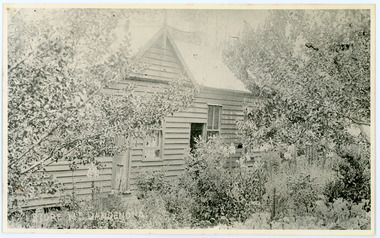
John Lundy-Clarke grew up in the Kalorama/Mt Dandenong area and later in life (1972-74) began to write a comprehensive history of the district working from an original settlement map in an effort to cover all areas. Edward Joseph Price was the first settler to take up a lot (Lot 1, Section 1) in the Village Settlement. He built a slab hut and brought up his family in 1896. This photograph shows a newer home built in 1908. It had a section used as a shop and also had a large room built that was to be used for public gatherings. Health department regulations led to this being impossible. The house faced Ridge Road.Black and white close up photograph showing a building made from wooden boards with trees in the front. Reverse of photograph has handwritten description by John Lundy-Clarke.On Front STORE MT DANDENONG On Reverse Home and Shop of Edward Joseph Price LOT 1 SECT 1 erected in 1908 on site of earlier dwelling from which goods had been sold without a special room for shop. In picture the room on the extreme left was bedroom for boys Charlie and Ted (Edward John). Under the gable was a large room planned for public use but never used owing to Health Department Regulations. The narrow door (open) and window were the shop which was the district’s first newsagency. Window behind leaves at right was the kitchen. 1908-1912. Gabled portion is now part of home “Mirra Laken” 1975edward joseph price, store, shop -
 The Beechworth Burke Museum Research Collection
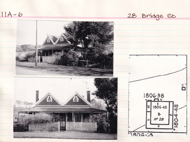
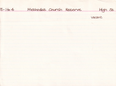
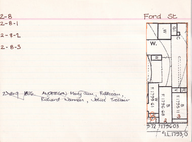
Card (Series) - Index Card, George Tibbits, 28 Bridge Street, Beechworth, 1976
George Tibbits, University of Melbourne. Faculty of Architecture, Building and Town & Regional PlanningIndex system that support the research for Beechworth : historical reconstruction / [by] George Tibbits ... [et al]Arranged by street names of BeechworthEach index card includes: street name and number of property, image of property, allotment and section number, property owners and dates of ownership, description of the property according to rate records, property floor plan with dimensions.beechworth, george tibbitsbeechworth, george tibbits -
 The Beechworth Burke Museum Research Collection
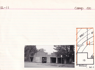
Card (Series) - Index Card, George Tibbits, Camp Street, Beechworth, 1976
George Tibbits, University of Melbourne. Faculty of Architecture, Building and Town & Regional PlanningIndex system that support the research for Beechworth : historical reconstruction / [by] George Tibbits ... [et al]Arranged by street names of BeechworthEach index card includes: street name and number of property, image of property, allotment and section number, property owners and dates of ownership, description of the property according to rate records, property floor plan with dimensions.beechworth, george tibbitsbeechworth, george tibbits -
 Bacchus Marsh & District Historical Society
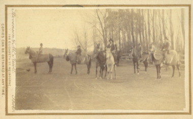
Photograph, Horses and riders from Woolpack Stables Bacchus Marsh 1883
This image is one of a series of photographs taken by Melbourne based photographers Stevenson and McNicoll who visited Bacchus Marsh and its nearby districts between September and November 1883. In 1850 a new Woolpack Inn was built for Mr. J.E. Crook, replacing the original slab building of 1845. Stables for twenty horses was also built in 1850, and in 1851, Crook established a coach service to the goldfields. After 1862, Crook pursued an interest in horse breeding, using the stables to accommodate his horses. The most notable of his horses was Saladin, which won the Australian Cup in 1872 after two dead heats with The Flying Dutchman. James Elijah Crook died in 1889.Small sepia 'carte de viste' style unframed photograph on card with gold border framing photograph. Housed in the Jeremeas Family Album which contains photographs of Bacchus Marsh and District in 1883 by the photographers Stevenson and McNicoll. The photo shows a group of men and horses from The Woolpack Inn stables, seven horses and six riders, one horse being held on a short rein by a rider on a white horse. Most of the horses are heavily clothed in winter rugs while the riders are clothed in sports jackets and hats. The scene is a winter one.Printed On the front: Stevenson & McNicoll. Photo. 108 Elizabeth St. Melbourne. COPIES CAN BE OBTAINED AT ANY TIME. On the back: LIGHT & TRUTH inscribed on a banner surmounted by a representation of the rising sun. Copies of this Portrait can be had at any time by sending the Name and Post Office Money Order or Stamps for the amount of order to STEVENSON & McNICOLL LATE BENSON & STEVENSON, Photographers. 108 Elizabeth Street, MELBOURNE. stevenson and mcnicoll 1883 photographs of bacchus marsh and district -
 Bendigo Historical Society Inc.
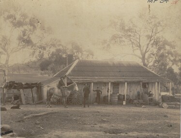
Photograph - FARMHOUSE NEAR MT SUGARLOAF - SLAB HUT, c.1880
Sepia photograph. Slab hut with bark roof, verandah. One brick chimney, weatherboard skillion at L end. One male under verandah. One male in yard. One male mounted on horse. Barrels, wheelbarrow, four wheeled horse drawn vehicle under or near verandah. Inscriptions on front 'MP94', in red ballpoint ink '28'.On Back in grey lead 'Axedale family near Sugarloaf'.( near Fosterville ) On back in red ball point pen '28'. History of object: Previous Acc. No. 'MP 94'. An important photo of early settlers showing type and construction of farmhouse, type of farm implements and clothingBendigo Advertiserbuildings, residential, cottage -
 Bendigo Historical Society Inc.
Newspaper - JENNY FOLEY COLLECTION: INSTITUTION
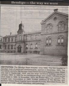
Bendigo Advertiser "The way we were" from 1999. Institution: The Bendigo Base Hospital, circa 1900. The first hospital in Bendigo, built of slabs and weatherboards, opened in November, 1853. The foundation stone for the Bendigo Gold District General Hospital in Lucan Street was laid in September, 1858, and the large sandstone building opened in January, 1859. In 1864, the two sandstone wings were added followed by the clock tower in 1866. In November, 1873, the Bowen Wing was opened. The hospital was incorporated in 1883. Further additions to the Bendigo and Northern District Base Hospital have included Kurmala, Stanisteet House, the George and Edith Lansell laboratory, and pathology.newspaper, bendigo advertiser, the way we were -
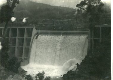
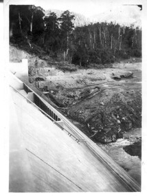
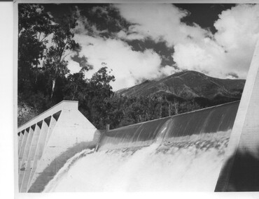 Kiewa Valley Historical Society
Photograph of Lake Guy Dam, Spillway, Lake Guy Dam, c1945
In December 1939 the excavation of the diversion tunnel at the site of Junction (Lake Guy) Dam was commenced and finished in February, 1940.This allowed the stream to be diverted to facilitate the dam wall construction. This is a 'slab and buttress' dam. It is framed with timber and concrete then poured into the structure. A contract was let to Lewis Construction Co. for the construction of the dam, and the first batch of concrete was placed in September, 1940. Industrial trouble caused some delays but there was also slow progress on the part of the contractor and the work was taken over by the S.E.C., terminating the contract. The dam was completed in March, 1944. The lake is named after Mr. L.T. Guy who was the Resident Engineer, in charge of construction work and associated activities on the Kiewa area, from 1939 until November 1946. An historical pictorial record taken for the State Electricity Commission of Junction Dam (Lake Guy) on spill. Mt. Arthur is in the background and there is still evidence of the destruction of trees from the 1939 bushfires. Black and white photograph of Lake Guy Dam . The dam is spilling and Mt. Arthur is in the background. Hand written on back of photograph in blue ink " Lake Guy Dam".dam, lake, water, mr. l.t.guy -
 Melton City Libraries
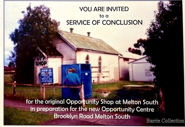
Flyer, Melton South Uniting Church Opportunity Centre, 2016
The Opportunity Shop – Established 1975 by Edna Barrie 1992 In 1985 the need for more shop space became apparent. Les [Bone] had plans drawn up (Surv 12/8/84) and approved by the Melton shire Council for a storeroom extension (17.800 x 9500) 1986 the small ancillary rooms at the rear of the timber church were demolished allowing the concrete slab to be laid. The building was completed in 1987. By the early 1900s the old timber Church had deteriorated, this lead to it being demolished in 2/11/1993. It was replaced with a new building containing a Pastoral Office, a meeting room and a furniture and homeware section. It was dedicated by Rev Ian Hickingbotham at 11am Sunday 5th June 1994. Invites to the service of conclusion of the original Uniting Church Opportunity Centre and official opening to the new shop in Melton Southchurches, local identities -
 Bacchus Marsh & District Historical Society
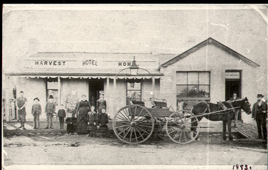
Photograph, Harvest Home Hotel Main Street Bacchus Marsh c.1880s-1890s
The Harvest Home Hotel was licensed as a beer shop in 1866. Patrick Vallence was the licensee. On his death in 1874 his widow Mrs M. A. Vallence obtained the license. The date that this image was created has not been identified. Around 1883 George Marshall was leasing the hotel. The people in this image are could be members of the Marshall family and some of the staff who worked in the hotel at this time. Following a decrease in the population of Bacchus Marsh by 1911 the hotel had lost its licence. The Vallence family still owned the building after the loss of the hotel license in 1911and it was used for some years after this as a private residence by some members of the Vallence family. Small black and white photograph. The image depicts the Harvest Home Hotel situated in Main Street Bacchus Marsh. The name of the hotel can be seen above the verandah roof. The building appears to be of stone with decorative stonework corners. A verandah is inset to the left of a gabled front section which has its own door and window. A deep gutter runs along the front of the hotel, with a slab acting as a bridge to the road. Standing in front of the building facing the camera is a group of adults and children, men and women and boys and girls. A four seated buggy drawn by a single horse is also present in the image. The lantern erected above the horse trough can be seen.hotels bacchus marsh, vallence family bacchus marsh, marshall family bacchus marsh, harvest home hotel bacchus marsh -
 Kiewa Valley Historical Society
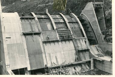
Photo - Junction Dam Construction, Circa 1940's
Junction (Lake Guy) Dam is a 'slab and buttress' type wall. A timber frame is built and then filled with concrete. The first batch of concrete was placed in September, 1940. By June, 1941 the buttresses were finished to a height safe from floods and in October of that year a flood of 2,800 cusecs occurred but with only slight damage to the installations. Industrial trouble caused some delays but there was also slow progress on the part of the contractor and the work was taken over by the S.E.C., terminating the contract. The dam was completed in March, 1944. A walkway was made through the dam wall. Lake Guy was named after Mr. L.T. Guy who was the Resident engineer, in charge of construction work and associated activities on the Kiewa Area from 1939 to November 1946Photos of the construction of the Junction Dam detail the harsh conditions faced by construction workers, building dams and villages to accommodate workers in the 1940s to the 1950s. Australia at this period in time, experienced a surge of population (influx of World War II refugees), which was the catalyst for developing and undergoing an enormous hydroelectricity program for the Alpine regions, both in Victoria and New South Wales. This program was initiated to supply electricity to the major southern Australian cities of Adelaide, Melbourne and Sydney. It was thought that these developments would reduce, if not eliminate, the requirement for coal driven power stations. However time has demonstrated that these power stations have not matched the demand required by the industries and the populations of the major urban and cities.Black and white photograph of Junction Dam constructionjunction dam, bogong, secv -
 Kiewa Valley Historical Society
Photo - Junction Dam Diversion Tunnel
Junction (Lake Guy) Dam is a 'slab and buttress' type wall. A timber frame is built and then filled with concrete. The first batch of concrete was placed in September, 1940. By June, 1941 the buttresses were finished to a height safe from floods and in October of that year a flood of 2,800 cusecs occurred but with only slight damage to the installations. Industrial trouble caused some delays but there was also slow progress on the part of the contractor and the work was taken over by the S.E.C., terminating the contract. The dam was completed in March, 1944. A walkway was made through the dam wall. Lake Guy was named after Mr. L.T. Guy who was the Resident engineer, in charge of construction work and associated activities on the Kiewa Area from 1939 to November 1946.Diversion dams are installed to raise the water level of a body of water to be redirected. The redirected water is used for hydro electric power generation. A diversion tunnel is usually bored through solid rock next to the dam site to bypass the dam construction site. The dam is built while the river flows through the diversion tunnel.Photos of the construction of the Junction Dam detail the harsh conditions faced by construction workers, building dams and villages to accommodate workers in the 1940s to the 1950s. Australia at this period in time, experienced a surge of population (influx of World War II refugees), which was the catalyst for developing and undergoing an enormous hydroelectricity program for the Alpine regions, both in Victoria and New South Wales. This program was initiated to supply electricity to the major southern Australian cities of Adelaide, Melbourne and Sydney. It was thought that these developments would reduce, if not eliminate, the requirement for coal driven power stations. However time has demonstrated that these power stations have not matched the demand required by the industries and the populations of the major urban and cities.Black and white photograph of Junction Dam diversion tunnel at Bogong VillageHandwritten on back - Junction Dam Diversional Tunnelbogong, secv, junction dam, lake guy -
 Kiewa Valley Historical Society
Photograph - Junction Dam spilling
Junction (Lake Guy) Dam is a 'slab and buttress' type wall. A timber frame is built and then filled with concrete. The first batch of concrete was placed in September, 1940. By June, 1941 the buttresses were finished to a height safe from floods and in October of that year a flood of 2,800 cusecs occurred but with only slight damage to the installations. Industrial trouble caused some delays but there was also slow progress on the part of the contractor and the work was taken over by the S.E.C., terminating the contract. The dam was completed in March, 1944. A walkway was made through the dam wall. Lake Guy was named after Mr. L.T. Guy who was the Resident engineer, in charge of construction work and associated activities on the Kiewa Area from 1939 to November 1946Photos of the construction of the Junction Dam detail the harsh conditions faced by construction workers, building dams and villages to accommodate workers in the 1940s to the 1950s. Australia at this period in time, experienced a surge of population (influx of World War II refugees), which was the catalyst for developing and undergoing an enormous hydroelectricity program for the Alpine regions, both in Victoria and New South Wales. This program was initiated to supply electricity to the major southern Australian cities of Adelaide, Melbourne and Sydney. It was thought that these developments would reduce, if not eliminate, the requirement for coal driven power stations. However time has demonstrated that these power stations have not matched the demand required by the industries and the populations of the major urban and cities.Black and white photograph of Junction Dam spilling at Bogong VillageHandwritten in pencil - Junction Dam spillingbogong, junction dam, lake guy, secv -
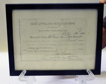 Orbost & District Historical Society
Certificate - share, 30/10/1940
Share certificate issued by New Gippsland Boulder Mine - operating at Errinundra and receipt for Herbert, Eric W. Receipt is for amount of four pounds - signed by Bird, W. Prospectus was printed in 1934 at office of Snowy River Mail - 4 page booklet. Gold, copper and silver were the target minerals.The crusher from the Boulder Mine is now at the Slab Hut in Orbost. The first Gippsland Boulder Co.,was at Boulder Creek – 13 miles north of Club Terrace, within 2 miles of Errinundra River. The company registered in January 1898 and commenced crushing in September with a 10-head battery. In the first nine months’ yields totalled 1,418 oz from 972 tons.There was a tramway between the mine workings and the battery.The crusher from the Boulder Mine is now at the Slab Hut in Orbost. This document is a reference for gold mining and exploration in the Far East Gippsland area. The Herbert family has reside in Orbost since the late 19th century.Copy of New Gippsland Boulder Mine share certificate and receipt. Framed in small black wooden frame.certificate-share-new-gippsland-boulder-mine mineralogy mining boulder-creek -
 Bendigo Historical Society Inc.
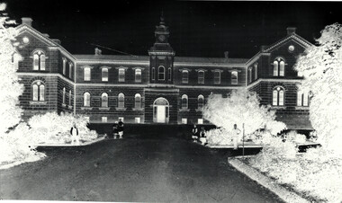
Document - Bendigo Base Hospital, 1853-1970s
The hospital was first mooted in 1853. The first site chosen was "Hospital Hill" between Rowan and Mackenzie Streets and behind the present Lister House School of Nursing. The first building was a primitive affair of slab and weatherboard daubed with clay somewhere near the middle of the present Short St - which at the time extended to the brow of the hill behind the Sacred Heart Cathedral site. The new building was greatly need to serve the hundreds of diggers then active on the field. Messrs Vahland and Gezchmann, Architects, designed a new building of stone and brick, the cenre portion of the hospital to hold 100 beds. This centre portion cost 12,000 pounds and was erected in three months. Patients were transferred from the old site on Hospital Hill to the new building in December 1858.Black and White photo negative of the front of the hospital; Notes on the History of "The Bendigo Gold District Hospital"; letters re classification by the National Trust of Australia (Victoria).history, national trust bendigo collection, bendigo, bendigo base hospital, bnedigo hospital, bnedigo gold district hospital -
 Bendigo Historical Society Inc.
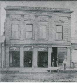
Photograph - VIEW POINT HOTEL: BENDIGO
Black and white photo: View Point Hotel, Charing Cross, Bendigo. 2 storey rendered building with parapet. 4 rectangular windows at top. 3 large windows and doorway at bottom. Portion of single storey building at left with corrugated roof verandah. At right, single storey building without verandah. At front, slab lined drain, wooden trough at front with horse. 2 males standing in doorway. Inside building at bar, 1 male, 1 female behind bar. Lamp at front centre. In image: M. Langridge's/View Point Hotel/ Imperial Fire Insurance co./Office/Gilles & Co/Stock and Share brokers. ' Williams' on back in pencil '15'.batchelderbuildings, hotel, view point hotel -
 Eltham District Historical Society Inc
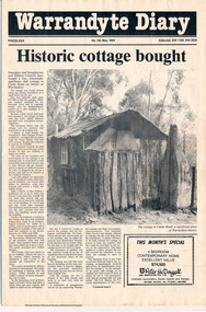
Folder, Warrandyte Miner's Cottage, 1984
Report and photograph about purchase of historically significant slab cottage in Castle Road, Warrandyte. Newspaper also includes articles relating to Jock Macneish and his ultra-light aircraft, construction of foot bridge over Andersons Creek, Mrs Ruth Norman, Warrandyte Co-op, local results of the 1981 census, construction of elderly citizens' flats in Stiggant Street (Warrandyte), South Warrandyte Primary School, Professor's Hill and Warrandyte Football Club. The road guide features advertisments for Inglenook Tea Rooms, Warrandyte, Warrandyte Recreation Reserve Cafe (Mrs C. Miller, Proprietress), Eltham Motor Garage, Plaza Cafe Eltham, Eltham Park Team Rooms, Diamond Creek Garage and Engineering Works and The Dean Guesthouse Strathewen.Complete issue of "Warrandyte Diary" No 145, May 1984 with feature article headed "Historic cottage bought". 12 pages with section cut out of back page. Also includes photocopy of Broadbents Roadguide: central Victoria, 1946 pages 230-231HG Booklet 281981 census, advertisment, andersons creek, castle road, diamond creek garage and engineering works, eltham motor garage, eltham park team rooms, footbridge, harry gilham collection, inglenook tea rooms, jock macneish, mrs c. miller, mrs ruth norman, plaza cafe eltham, professor's hill, senior citizens, south warrandyte primary school, stiggant street, the dean guesthouse strathewen, warrandyte, warrandyte co-op, warrandyte football club, warrandyte recreation reserve cafe, warrandyte slab cottage -
 Bendigo Historical Society Inc.
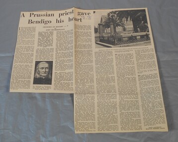
Newspaper - Lydia Chancellor collection: A Prussian priest gave Bendigo his heart
George Henry Backhaus (1811-1882) was born in Prussia. He was ordained as a Catholic priest in 1836 and began his missionary work in India. In 1846 he came to Australia, first ministering in Sydney and then Adelaide. With the discovery of gold in Victoria, Backhaus believed he was called to become a missionary on the goldfields. His first Bendigo mass was celebrated 2/5/1852. He travelled extensively throughout the goldfields eventually establishing a tent church on the site of St Killians in 1852. In 1853 this was replaced by a slab-walled and canvas-roofed church.. The site also included a Catholic school. In 1863 he returned to Germany but came back to Bendigo in 1867. He retired from parish work in 1881 and moved to Melbourne but as his health declined he returned to Bendigo in 1882 to die.The age from 08/01/1966. Article titled: A Prussian priest gave Bendigo his heart, Churches of history - 9 by John Hetherington. The article details the life of Dr. Henry Backhaus, the first Catholic priest in Bendigo.In blue pen "The Age" 8-1-66bendigo churches, backhaus, st.killian -
 The Beechworth Burke Museum Research Collection
Card (Series) - Index Card, George Tibbits, Corner Church, Ford & High Streets, Beechworth, 1976
George Tibbits, University of Melbourne. Faculty of Architecture, Building and Town & Regional PlanningIndex system that support the research for Beechworth : historical reconstruction / [by] George Tibbits ... [et al]Arranged by street names of BeechworthEach index card includes: street name and number of property, image of property, allotment and section number, property owners and dates of ownership, description of the property according to rate records, property floor plan with dimensions.beechworth, george tibbitsbeechworth, george tibbits -
 The Beechworth Burke Museum Research Collection
Card (Series) - Index Card, George Tibbits, 39 Ford Street, Beechworth, 1976
George Tibbits, University of Melbourne. Faculty of Architecture, Building and Town & Regional PlanningIndex system that support the research for Beechworth : historical reconstruction / [by] George Tibbits ... [et al]Arranged by street names of BeechworthEach index card includes: street name and number of property, image of property, allotment and section number, property owners and dates of ownership, description of the property according to rate records, property floor plan with dimensions.beechworth, george tibbitsbeechworth, george tibbits -
 Eltham District Historical Society Inc
Photograph, Peter Pidgeon, Birch Cottage, Eltham-Yarra Glen Road, Christmas Hills, 27 September 2018, 2018
Originally built by John Hill, a shoemaker at Kangaroo Ground around 1878. In the late 1970s when our Society was the Shire of Eltham Historical Society, an offer was made to the Society regarding use of an old cottage at Christmas Hills. The cottage sat beside Watsons Creek just outside the then Shire of Eltham but following municipal restructuring it now lies within the Shire of Nillumbik. For various reasons the offer ultimately lapsed. At that time some research on the cottage was carried out for the Society by Keith Chappel as part of a larger research project that he was doing. Keith’s notes were taken from Lands Department records and showed that the property was the subject of a permissive occupancy of Crown land comprising the creek reserve. In 1903 a Miner’s Right of one acre in area was granted to Edwin Samuel Birch. In 1907 Birch applied to purchase this land but was unable to because it was part of the creek reserve. The documents show that the cottage existed at that time. Upon Birch’s death in 1932, his daughter, Honor Mary Birch was granted a permit to occupy the residence. Honor Mary Birch, known as Nora, was born 1900, the daughter of Edwin Samuel Birch and Honor (nee Young). In 1939 she married George Henry Williams (aka Henry). Honor died 8 July 1976. Her siblings were Margaret Martin (dec), Bert Birch and Brigidene Brinkkotter. In her will she gave and bequeathed “all the improvements on the land held by me at Christmas Hills under Permissive Occupancy from the Department of Land and Survey consisting of the house property thereon and all the contents of the said house to my nephew Brian Joseph Martin of Christmas Hills aforesaid farmer”. The will described the property as a four room, five square house, about 100 years old with enclosed verandah, including kitchen, combined lounge dining room, bedroom and store room; built of ‘bush slabs’ with a corrugated iron roof. A dairy had been erected in 1935. After her death, the property was acquired by the Melbourne Metropolitan Board of Works in 1978. The property is listed on the Victorian Heritage Database HO200-Hill, later Birch farm complex, 945 Eltham-Yarra Glen Road, Watsons Creek and described as: The house has a steep but simply gabled roof form clad with corrugated iron, vertical adzed hardwood slab front wall construction, split palings to the gable ends; rubble freestone chimney at one end (with added gsi flue), pole-framed Graeme Butler & Associates, 2006: 101 Shire of Nillurnbik Planning Scheme Amendment C13 Heritage Assessments verandah (rebuilt?); six-pane double-hung sash windows; T&G bead-edge boarded ledged & braced door; and paling clad rooms added at verandah ends. A slab-clad large fireplace is at the north corner of the house, with a gsi upper cladding added and an internal lining of rubble stone. The rear facade is different construction, being drop-slab, and sits beneath a rear skillion addition to the main gabled form: this may be more recent construction. The house appears to have been once set up for public display and may have been recreated in part for that purpose. Outbuildings are reached by a track along the east side of the house, including what may have been a creamery (typical standard inter-war design clad with corrugated iron and lined with 1938 Lysaght Queens Head Australia galvanised sheet iron) and a paling clad gabled out-house. Timber outbuildings of differing eras are to the north-west of the house, with pole framing and paling infill construction and Redcliffe brand corrugated iron. Post and rail (front) and split paling (rear) fence remnants line the front boundary. Pepper trees part of house yard landscape49 born digital images (includes one panoramic stitch and nine frames from drone video)birch cottage, christmas hills, early settlers, edwin samuel birch, honor mary birch, john hill, watsons creek -
 Bendigo Historical Society Inc.
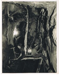
Photograph - MINERS AT WORK: BENDIGO
black and white photograph of two workmen seated on bush timber fitted between vertical rock faces. The ladder is probably from the level immediately below. The lamps are ' Bendigo bucket carbide lamps ' Some advisers consider consider that this photograph is posed as workers are not safely placed. In grey lead ' miners at work ' down below' in Bendigo ' a signature ' J.J. Stanistreet ' a caption ' Hercules Mine ' ? On back in black pen ' miners shaping shaft prior to ' boxing in' with red gum slabs - note white quartz reef on wall face ' On small paper inclusion ' Miners placing staging for stoping on spurs' Mining Revival C 1930's.. James Lerk 26 Nov. 1999 - not as described in ink on rear 'person, group, mining -
 Bendigo Historical Society Inc.
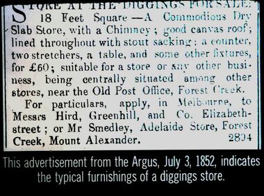
Slide - DIGGERS & MINING. STORES AT THE DIGGINGS, c1852
Diggers & Mining. Stores at the diggings. Store at the digging for sale: 18 Feet Square - A Commodious Slab Store, with a Chimney; good canvas roof, lined throughout with stout sacking: a counter, two stretchers, a table, and some other fixtures, for 60 Pounds; suitable for a store or any other business, being centrally situated among other stores, near the Old Post Office, Forest Creek. For particulars, apply, in Melbourne, to Messrs Hird, Greenhill, and Co. Elizabeth street: of Mr Smedley, Adelaide Store, Forest Creek, Mount Alexander. 2804. This advertisement from the Argus, July 3, 1852, indicates the typical furnishings of a diggings store. Markings: 5 994.LIF. 5. Used as a teaching aid.hanimounteducation, tertiary, goldfields -
 The Beechworth Burke Museum Research Collection
Card (Series) - Index Card, George Tibbits, Camp Street (Cnr Camp & High Streets), Beechworth, 1976
George Tibbits, University of Melbourne. Faculty of Architecture, Building and Town & Regional PlanningIndex system that support the research for Beechworth : historical reconstruction / [by] George Tibbits ... [et al]Arranged by street names of BeechworthEach index card includes: street name and number of property, image of property, allotment and section number, property owners and dates of ownership, description of the property according to rate records, property floor plan with dimensions.beechworth, george tibbitsbeechworth, george tibbits -
 The Beechworth Burke Museum
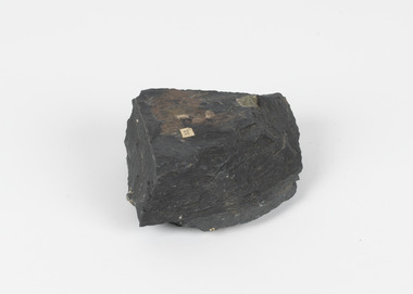
Geological specimen - Slate with Iron pyrites
This specimen was recovered from Moonambel, Donkey Hill, Victoria. Established in the early 1860's, Moonambel is a small town in the Pyrenees region of the Australian state of Victoria. In the 1850s the location of Moonambel was part of the ‘Mountain Creek’ pastoral run, but in 1860 reports began to appear of a gold-rush at McKinnon’s ‘Mountain Creek’ station. By 1861, a township had developed on the diggings site, and on 21 October 1861 the “municipal district of Moonambel, on Mountain Creek” was proclaimed. The name 'Moonambel' is believed to be an aboriginal word meaning 'hollow in the hills'. Slate is a stone with a fine grain that is noted for its persistent strength and ability to naturally split into slabs. It forms under low temperatures and is most often created from clay. Pyrite is a crystallising compound that occurs naturally in grey and blue-black slate that is colloquially referred to as slate-rust as it resembles regular rust. This specimen is part of a larger collection of geological and mineral specimens collected from around Australia (and some parts of the world) and donated to the Burke Museum between 1868-1880. A large percentage of these specimens were collected in Victoria as part of the Geological Survey of Victoria that begun in 1852 (in response to the Gold Rush) to study and map the geology of Victoria. Collecting geological specimens was an important part of mapping and understanding the scientific makeup of the earth. Many of these specimens were sent to research and collecting organisations across Australia, including the Burke Museum, to educate and encourage further study.Pyrite is iron sulphide (also known as “fool's gold”) which is commonly found in slates.Existing label: 53 /moonambel, slate, pyrite, burke museum, beechworth, indigo shire, beechworth museum, geological, geological specimen, mineralogy, victoria -
 Kiewa Valley Historical Society
12 small black and white photgraphs of Junction Dam and surrounding area, Photo No. 1 c1940, all others c 1948
Junction Dam is a reinforced slab and buttress type construction and was commenced in February, 1940 by Lewis Construction Company. Stiff leg derricks were erected at appropriate locations at the site of the dam and used for the disposal of excavated material and the placing of concrete. A rock crushing and screening plant was established at a site a short distance upstream from the dam site and concrete was supplied from a central mixing plant placed close to the upstream toe of the structure. The SEC took over the construction in April 1942 and the dam wall was completed in March, 1944. Bogong township was commenced in early 1940 with the construction of a workmen's camp housing 96 men, (known as Junction camp). Construction of housing for families commenced shortly after. Forty houses, plus office, workshops, stores and laboratory accommodation were completed over the next 5 years,Of historical significance as a pictorial record of Junction Dam, Lake Guy and Bogong Village, as the photos were taken only 4 years after completion and one photo taken on completion of the dam wall but before the lake was filled with water.12 small black and white photographs of Junction Dam, Bogong Village and surrounding area.Photo 1 - On the back upper edge in pen 'Junction Dam'. Then '12' in pencil, circular stamp, printed in centre 'Print by Willson White Albury'. Photo 2 - On the back upper edge in pen 'Junction Dam October 1948'. Stamp as no. 1 photo. Stamp '998L' lower centre. Photo 3 - on the back upper edge in pen 'Junction Dam October 1948'. Circular stamp with 'Kodak Print' . Lower centre back is stamped 'velox' and '998L'. Photo 4 - upper back, in ink - 'Junction Dam Spion Kopje in background. October 1948'. Stamps as photo no. 4. Photo 5 - upper back, in ink - 'Lake Guy (orange filter) October 1948'. Centre back, in pencil '29' and circular stamp with words 'Print by Willson White Albury'. Photo 6 - upper back edge 'Junction, Bogong from Radio Receiving Shack Dec. 1948'. In pencil '14'. Photo 7 - On back of photo 'View of Mountains from Little Arthur Fire Track October 1948'. Two circular stamps with 'Kodak Print', another two stamps - 'Velox' and '998L'. Photo 8 - On back in ink 'Loone's Store Bogong with Spion Kopje in background. October 1948'. Lower down, stamps 'Velox' and '998L'. Part of circular stamp with one word 'Kodak'. Photo 9 - on back in ink 'Junction Camp, Bogong Village & Lake Guy from Little Arthur Fire Track. October 1948'. Stamped across writing '998L'. Lower down stamped 'Velox' and circular stamp with words 'Kodak Print'. Photo 10 - on back in ink 'Junction Camp & Bogong Village Lake Guy in Foreground. October 1948'. Stamps as photo 9. Photo 11 - on back in ink 'Junction Camp & Bogong Village, Lake Guy in Foreground. October 1948'. Lower stamp '998L'. Photo 12 - 'Junction of Rocky & Pretty Rivers with tennis courts in foreground October 1948' . Circular stamp with words, 'Print by Willson White Albury'. Number '29' written pencil.junction dam; bogong village; kiewa hydro electric scheme; lake guy -
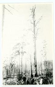 Mt Dandenong & District Historical Society Inc.
Photograph
William Dower came with his family to the Mt Dandenong in 1898, taking up a 10 acre allotment. William and his wife Elizabeth had seven boys (Will, Harry, Bert, Walter, Joe, Edgar, Robert) and four girls (Emmy, May, Ada, Ruby). The property secured by William Dower was known as ‘Cambridge Gardens’ and had a two room slab hut. William and his sons added another five rooms using trees from the property. The family established extensive crops and worked hard for their success. The acreage extended to 30 when the family bought up neighbouring properties. Standing on William Dower's land this mighty tree was 286 feet high to its broken top with a 66 feet girth. It took Wally and Bert Dower a week to grub out the tree and then another week for the wind to blow it down.Black and white photograph with a very tall dead tree in the centre. A group of people visible in the foregrounddower, william dower, tree, wally dower, bert dower -
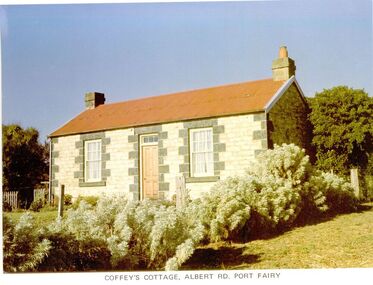 Port Fairy Historical Society Museum and Archives
Photograph
65 Albert Road. the land was first owned by George Bull when he bought it in 1860. The house was built around 1862. Members of the family owned it until 1893 when it was sold to William Johnson. Johnson died in 1897 and Catherine Sara Ryan nee Hain bought it and lived there until she died in 1927. The cottage was then sold to the Coffey family who retained the property until 1974. The cottage is conventional coursed limestone building with bluestone quoins, gabled roof, chimneys at each end and a skillion on the western side, added at a later date. It was originally a two-roomed dwelling with kitchen. Behind the cottage is a slab-sided wooden gable ended shed, containing a large limestone rubble chimney and a sleeping area within the south facing skillion section. It is unlikely that it is older than the cottage, but it is an unusual, crude structure, presumably for general farming purposes.Coloured photographcottage, building, home, house, coffey's cottage, albert road, ryan, hain, johnson, george bull -
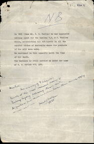 Melbourne Legacy
Document, Stan Savige, 1954
Typed notes on the life of Legatee Stan Savige's business. It says: "In 1923 (then Mr S G Savige) he was appointed selling agent for the Geelong R. S. & S. Woollen Mills, establishing his sub-agents in all the capital cities of Australia where the products of the mill were sold. He continued in this capacity until the time of his death. The business is still carried on under the name of S.G. Savige Pty Ltd." With an added note from Frank Doolan dated 1/1/1958, that the attached pages include a copy of Legatee Schofield's speech at the first Annual Meeting of Geelong Legacy following Stan's death. He says it quotes a few slabs verbatim from Stan's speech of 4/11/1939. That speech titled 'Legacy and Sister Clubs' is also in the archive. It was sent to Frank Doolan as part of an early archive project.A record of a speech at Geelong Legacy that honours Stan Savige.Note on white foolscap paper with some biographical details of Legatee Savige and a hand written note saying the attached was Legatee Schofield's speech about Savige.stan savige, geelong legacy