Showing 5602 items matching " suburbs"
-
 City of Kingston
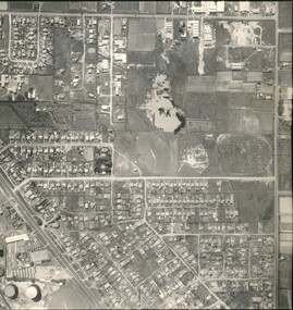
Photograph - Black and white, Aerial photograph Highett, 26 March 1956
Part of broad aerial photographic survey of the area. Aerial photograph Highett - Highett Reserve, Sandpits, Gasworks, Nepean Highway, Chesterville Road, Wickham Road.The photograph shows the development of the city of Highett, suburban expansion and industrialisationsquare black and white photographic print on paper, with thick black border; printed text on bottom indicating date and other reference codeshighett, city of moorabbin, aerial photograph, suburbs, highett gas works, recreation, infrastructure -
 Greensborough Historical Society
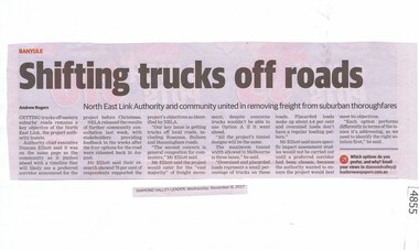
Newspaper Clipping, Diamond Valley Leader, Shifting trucks off roads, 08/11/2017
Getting trucks off eastern suburbs' roads remains a key objective of North East Link, the project authority insists.News article 1 page, black text.north east link, rosanna, banyule, rosanna road, trucks -
 Melbourne Tram Museum
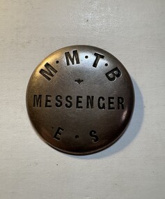
Badge - "MMTB Messenger ES", Stokes and Sons, 1920s
Use to identify a tramway employee, involved in delivery of messages, correspondence etc in the Eastern Suburbs system. Made by Stokes and SonsDemonstrates the method of identifying MMTB employees.Round pressed brass badge with the words "Messenger" pressed into the centre of the badge, around the bottom portion of the badge, the letters "ES". Has a nickel-plated finish with the MMTB initials on the top part of the badge. On the rear of the badge, two metal lugs have been soldered onto the badge to enable it to be worn on a uniform with a leather strap on a button.badges, mmtb, messenger -
 St Kilda Historical Society
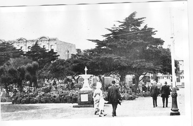
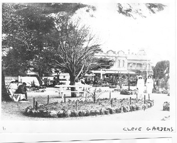
Photograph, Cleve Gardens, c. 1915-1916
St Kilda, c. 1915-1916black and white photograph, unmountedCleve Gardens c/r Fitzroy St & Beaconsfield Pde. Handwritten on back Melbourne - Suburbs - St Kilda. The Cleve Reserve corner of Fitzroy Street and Beaconsfield Parade. St Kilda by the Sea p32 �Stamped National Library of Australia Canberra -
 St Kilda Historical Society
Photograph, St Kilda By the Sea Annual, Paradise Pictures, Esplanade, St Kilda c1915, c. 1915
copy(?) of black and white photograph fair conditionHand written on back: U 4 Paradise, C 154, and Melbourne Suburbs St Kilda Paradise, St Kilda by the Sea Annual p.84 Season 1915-16 F 600:65 Stamped National Library of Australia, Canberra -
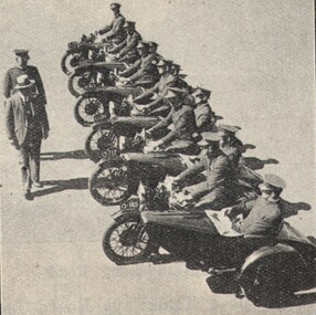 Victorian Interpretive Projects Inc.
Image, Motorcycle Police, 1934, c1934
In 1934 Melbourne city and suburbs were divided into areas and patrols. The patrols were covered by motor cycles, bicycles and foot constables. Eleven police officers sit on motorbikes with side cars, and are being inspected by two people.police, motorcycle, motorbike, -
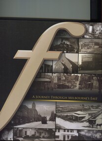 Surrey Hills Historical Society Collection
Book, A journey through Melbourne's east, 2008
Pictorial representation of the development of Melbourne's eastern suburbs. A collection of photographs of the local eastern area of Melbourne showing a lot of 'then' and 'now' photographs.A collection of photographs of the local eastern area of Melbourne showing a lot of 'then' and 'now' photographs.fletcher and parker, fletchers, real estate agents, melbourne, hawthorn, balwyn, camberwell, kew, land use, ashburton, montagnana-wallace, (mr) neil wallace, (mr) neil montagnana -
 City of Kingston
Pamphlet - Colour, Roy Dunn Pty. Ltd, Central Corner Estate Moorabbin and Highett, c. 1923
Sales plan for land in the suburbs of Highett and Moorabbin, bordered by Point Nepean Road and Wickham Road East incorporating William StreetThe developing urban area of Highett and Moorabbin within the City of Kingston. This land sale pamphlet illustrates the subdivision of land within the municipality and the changing demographic of the district as new houses are constructed close to infrastructure.Colour pamphlet advertising for private sale land in the Central Corner Estate in Moorabbin and Highett. Incorporates a map of the estate bordered by Point Nepean Road and Wickham Road East, with subdivisions also available on both sides of William Street. Handwritten in blue pencil on subdivision plan: a tick is drawn on subdivisions 2-18 Handwritten in blue pencil on subdivision 6: a box with an x inside Handwritten in blue pencil on subdivisions 10 and 12: S Handwritten in black ink on front page: [indecipherable] / McKittricks Handwritten in grey pencil on rear page: McKilhick / Nepean Rd Handwritten in grey pencil on rear page upside down: 160000 / 15 8300 [crossed out] land sales, estate, highett, moorabbin -
 Ballarat Tramway Museum
Memorabilia - Set of 17 reproduction Sydney Destination Rolls, 1965
Set of 9 replica destination rolls produced by the AETA, mid-1960s to give details of each destination roll of Sydney tram or trolley buses. 1 - Western suburbs - AETA No 1 - 1250mm long 2 - Eastern suburbs - AETA No. 2 - 1150mm long 3 - North Sydney - Manly - AETA No. 3 - 1040mm long 4 - Watsons Bay - AETA No. 4 - 700mm long 5 - Newcastle - AETA No. 5 - 620mm long 6 - Enfield Depot - AETA No. 6 - 363mm long 7 - Wylde St Trolley Bus AETA No. 8 - 112mm long x 71mm wide 8 - Kogarah Trolley bus - AETA No. 9 - 305mm long x 71 mm wide 9 - North Sydney - Manly AETA No. 12 - 690mm long x 50mm wide 10 - Eastern Suburbs - AETA No. 14 - 770mm long x 50mm wide 11 - Western Suburbs - AETA No. 16 - 1270 long x 50mm wide 12 - North Sydney / Manly side - AETA No.17 - 519mm long x 80mm wide 13 - Western Suburbs side - AETA No. 18 - 665mm long x 80mm wide 14 - Watsons Bay - AETA No. 20 - 1160mm long x 48mm wide 15 - Eastern Suburbs - AETA No. 21 - 11540mm long x 48mm wide 16 - North Sydney - AETA No. 22 - 750mm long x 48mm wide 17 - Eastern Suburbs Side - AETA No. 23 - 523mm long x 87mm wide The envelope in which they were received by the donor - preprinted for the Electric Traction magazine with a 2/5d stamp, Registered mail has been retained. Date stamped 30 Aug. 1965. Yields information about Sydney tramcar and trolley bus destination rolls.Set of 18 paper rolls of varying length, printed and joined by glueing.tramways, destination rolls, sydney, aeta, destination roll, buses, trolley buses -
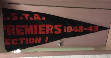 Kew Historical Society Inc
Award, Auburn Heights Tennis Club, ESTA Premiers Section 1 Pennant, 1948-1949
Sports Clubs in Kew in the final decades of the 19th century and in the early 20th century were often umbrella organisations with facilities for a number of sports. Typically in Kew, this included teams in lawn bowls, tennis and croquet. The Kew Bowling Club was formed in 1880 while the privately owned Auburn Heights Recreation Club was opened in 1904. By 1998, the two Clubs decided to amalgamate at the Auburn Heights site in Barkers Road, forming the Kew Heights Sports Club. The combined club was itself taken over by the Melbourne Cricket Club in 2012 becoming MCC Kew Sports Club. In 2017 MCC Kew closed and its landholding was subsequently sold to Carey Baptist Grammar School. Both the Kew and Auburn Heights Clubs assembled important collections. These historically significant and large collections were donated to the Society in 2020. The collections include manuscripts, pictures, trophies, plans, honour boards etc. References Barnard FGA 1910, 'Sports and Pastimes' in Jubilee History of Kew Victoria: Its origin & progress 1803-1910. Chapman J & C 1999, The history of the Auburn Heights Recreation Club, 1904 to 1908. Reeve S 2012, City of Boroondara: Thematic Environmental History, p.216.The combined collections of the four sporting clubs making up the collection number hundreds of items that are historically significant locally. They are also significant to the sporting history of the greater Melbourne area and to the sports of lawn bowls and tennis in Australia in the 19th and 20th centuries. The collection illuminates two of the Victorian historic themes - 'Building community life' through forming community organisations and 'Shaping cultural and creative life' by participating in sport and recreation.Black cloth pennant with appliquéd red lettering identifying the Auburn Heights Tennis Club as winners of the ESTA (Eastern Suburbs Tennis Association) Premiers Section 1 1948-49. [The item forms part of the large historic Auburn Heights Recreation Club collection, with items relating to the sports of lawn bowls, tennis and croquet, gifted to the Kew Historical Society in 2020].E.S.T.A. / PREMIERS 1948-49 / SECTION 1auburn heights recreation club - barkers road - kew (vic), auburn heights tennis club - pennants, e.s.t.a -
 Melbourne Tram Museum
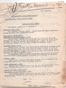
Document - Instruction, Melbourne & Metropolitan Tramways Board (MMTB), "Easter Season - 1941", Feb to April 1941
Set of 24 quarto sheets, typed some carbon copy, some original on MMTB departmental paper outlining the Easter Services for 1941 for the various depots, routes, frequency and tables to be operated. Written for both the Northern and Southern districts, including bus services. Signed by J. M. Harry District Traffic Superintendent Southern and C. E. Hall, northern suburbs.On top edge in heavy black pencil "Easter Season 1941"trams, tramways, mmtb, public transport, holiday arrangements, buses, services -
 Melbourne Tram Museum
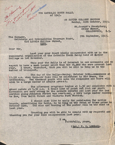
Letter, St Joseph's Presbytery, Catholic Youth Rally, 9/09/1943 12:00:00 AM
Catholic Youth Rally of 1943 Sunday 24 October 1943, 11:50 AM Letter from FW Lombard to MMTB advising of event and requesting permission to display advertising material on trams. Letter also informs that bus services along Johnston St were inadequate for the number of people attending from the Northern suburbs. Memos dated 9 September 1943."Copy Mr Harry for information and attention. WR 10/9/43" written in top left corner in red ink.trams, tramways, events, festival, johnston st -
 Whitehorse Historical Society Inc.
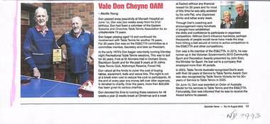
Article, Don Cheyne OAM, Aug 2023
Don Cheyne OAM died on 01/06/2023non-fictionDon Cheyne OAM died on 01/06/2023eastern suburbs and churches table tennis association, cheyne don oam, st ninian's unitingchurch blackburn south, mahoney's reserve -
 St Kilda Historical Society
Photograph, Cleve Gardens, c. 1915-1916
St Kilda, c. 1915-1916black and white photograph, unmountedCleve Gardens c/r Fitzroy St & Beaconsfild Pde. Handwritten on back Melbourne - Suburbs - St Kilda. The Cleve Reserve corner of Fitzroy Street and Beaconsfield Parade. St Kilda by the Sea Annual p35 �Stamped National Library of Australia Canberra -
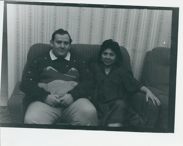 Uniting Church Archives - Synod of Victoria
Photograph, c. 1986
Fred and Christine Stern were house parents for Maroondah Youth Accommodation Project that supplies emergency accommodation for disadvantaged youth of the eastern suburbs of Melbourne.B & W gloss photograph of Fred and Christine Stern seated on a couch.fred stern; christine stern; maroondah youth accommodation project -
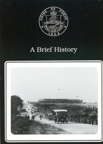 Greensborough Historical Society
Booklet, Shire of Corio, A Brief history of the Shire of Corio, 1980s
History of Shire of Corio, a local government area between Geelong and Werribee. The Shire included all of Geelong's northern suburbs and existed from 1861 to 1993.12 p., printed in green on white paper, photographs, stapled.geelong, shire of corio, werribee -
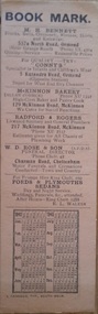 Hymettus Cottage & Garden Ballarat
Work on paper - Bookmark, Calendar Bookmark
This bookmark illustrates advertising techniques using this medium in the 1940s Melbourne suburbs with a calendar for 1945 and 1946. It highlights a variety of businesses including a local circulating library.The Hymettus Bookmark Collection provides a comprehensive insight into commercial advertising and promotion using the medium of the bookmark in Australia and also places Australia's bookmarks in a transnational context from the nineteenth to the twenty-first centuries. This collection of bookmarks forms arguably the largest private collection in Australia. This bookmark highlights local businesses in the area in the 1940s and the place of circulating libraries in the suburbs.Niladvertising, ormond, mckinnon, cheltenham -
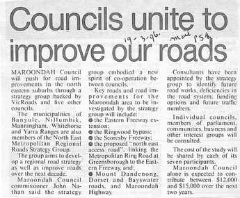 Ringwood and District Historical Society
Newspaper, Scrapbook Clipping, Library Collection, Ringwood, Victoria
Newspaper Clipping from The Mail, 19-3-96, P 5. Councils unite to improve our roads.Maroondah Councilwill push for road improvements in the north eastern suburbs through a strategy group backed by Vicroads and five other councils. The municipalities of Banyule, Nillumbik, Manningham, Whitehorse and Yarra Ranges are also members of North East Metropolitan Regional Roads Strategy Group. -
 City of Kingston
Photograph - Colour, 1998
The name Mordialloc was derived from the name Moody Yallock, which comes from the Bunurong language. The Bunurong Peoples are the Traditional Owners of this area. The name means “high water” or “high creek”. In 1839, colonial authorities declared the mouth of the creek, and an additional 830 odd acres as an Aboriginal Reserve, although this proclamation was never gazetted. The reserved land included part of the Carrum Carrum Swamp which was abundant with wild life and natural resources. Regular encroachments, including land sales which began in 1863, were made on the land until 1878 when the Reserve was declared closed, and the land was opened up to land sales. Market gardening and suburban house lots quickly began to develop, and Mordialloc became a renowned picnic and holiday site. Mordialloc Creek is a popular bay side destination for local and visitors, and is a site for boating, kayaking, fishing and swimming, along with many other activities.Colour photograph of Mordialloc Creek, looking inland.Small fishing and leisure boats are moored on either side of creek, with a view of the Mordialloc Bridge Hotel in the background.mordialloc, bunurong, traditional owners, suburbs, boats, fishing, waterways, hotel -
 City of Kingston
Photograph - Colour, Paul Tresize, 1998
The name Mordialloc was derived from the name Moody Yallock, which comes from the Bunurong language. The Bunurong Peoples are the Traditional Owners of this area. The name means “high water” or “high creek”. In 1839, colonial authorities declared the mouth of the creek, and an additional 830 odd acres as an Aboriginal Reserve, although this proclamation was never gazetted. The reserved land included part of the Carrum Carrum Swamp which was abundant with wild life and natural resources. Regular encroachments, including land sales which began in 1863, were made on the land until 1878 when the Reserve was declared closed, and the land was opened up to land sales. Market gardening and suburban house lots quickly began to develop, and Mordialloc became a renowned picnic and holiday site. Mordialloc Creek is a popular bay side destination for local and visitors, and is a site for boating, kayaking, fishing and swimming, along with many other activities.Colour photograph of Mordialloc Creek, looking inland. Boats are moored on either side of the creek and the Bridge Hotel is visible in the background.mordialloc, bunurong, traditional owners, suburbs, boats, fishing, waterways, hotel -
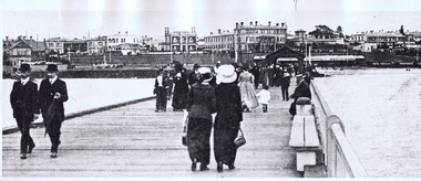 St Kilda Historical Society
Photograph, St Kilda Pier. View of Esplanade from Pier 1915-16, c. 1915
black and white photograph (a copy?)Inscription: View of Esplanade from Pier 1915-1916. Melbourne - Suburbs - St Kilda. View of Esplanade from the Pier. St Kilda by the Sea Annual, p.21. Season 1915/16. F600:65. Stamped National Library of Australia, Canberra. H 76 -
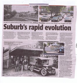 Greensborough Historical Society
Newspaper Clipping, Diamond Valley Leader, Suburb's rapid evolution, 12/04/2017
Eltham was described as a blossoming township and featured in the top 10 fastest growing Victorian suburbs during the 1960s. This article looks at some historic sites in Eltham and how they look today.News article 2 pages, black text, colour image.eltham, changes over times -
 Robin Boyd Foundation
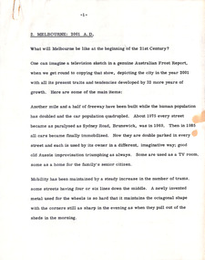
Document - Manuscript, Robin Boyd, Melbourne: 2001 AD, 1969
Searing critique on the public apathy of the environment in which we live, as well as the dichotomy of the professional view of the city and suburbs. Boyd imagines what Melbourne might be like in year 2001.Original manuscript of an article published as 'Melbourne 2001 AD' in "The Australian", 05.03.1969. This is the second of a series of three articles about Melbourne published on consecutive days (see D022 and D024).Typewritten (c copy), quarto, 7 pagesmelbourne, trams, flies, road congestion, robin boyd, manuscript -
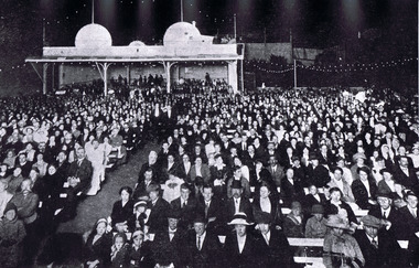
 City of Kingston
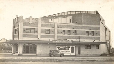
Photograph - Digital image, Black and white, c.1928
Image of the newly opened Mentone Picture Theatre located on Point Nepean Road in Mentone. Local picture theatres abounded in the in the suburbs of Kingston from the 1920s through to the late 1950s. The New Mentone Picture Theatre was dreamt up and developed by Albert Lydford who along with other promoters, formed a company that provided the finance for the erection of a large cinema right at the junction of Balcombe Road and Point Nepean Road. The New Mentone Picture Theatre operated in competition with a council owned facility on Brindisi Street and within three years of opening, the council theatre was closed. The New Mentone Theatre flourished until the late 1950s. It offered three changes of program each week. Two movies screened on Mondays and Tuesdays. On Wednesday a new bill went on for just one night, and then the main feature of the week, a movie the likes of Casablanca, was shown from Thursday through to Saturday. During its heyday there were full houses almost weekly. Saturday night shows were often booked out in advance and some families had permanent bookings at weekends. Locals treated the place as a centre of social activity, a venue for an enjoyable night out that did not involve great expense or long travel times. The advent of television in the 1950's, saw the theatre close forever in 1960.Sepia toned image of the New Mentone Picture Theatre, located on Point Nepean Road, Mentone.theatre, movies, mentone, entertainment -
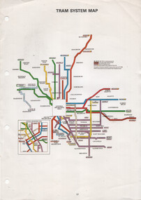 Melbourne Tram Museum
Map, The Met, "Tram System Map", c1990
Tram system map published by The Met to show the various Melbourne tram routes, route numbers, principal road names, suburbs and tram routes within the Central Business District.Provides information about Melbourne tram routes c1990Printed A4 full colour sheet with four punch holes on left hand side.tramways, melbourne, the met, map, tram routes, routes -
 Melbourne Tram Museum
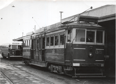
Photograph - St Kilda Station - tram 35 and half cab bus, The Age, July 1957
Photo, from The Age used in item 7194 reporting on the closure of the St Kilda - Brighton tramway from Elwood depot to Middle Brighton on 1/7/1957. Photo shows Victorian Railways tram No. 35 at St Kilda Railway station with the privately operated bus behind. The service was operated by the Eastern Suburbs Omnibus Service using some half-cab buses. The bus is a Leyland OPS4 built in 1950 and subsequently sold to Eastern Suburbs Omnibus service in 1957. Was it on hire to the Brighton bus company? Yields information about replacement of trams on the St Kilda Brighton line by buses in July 1957. Photograph - St Kilda Station - tram 35 and half cab bus - has "The Age" stamp on the rear.Has notes on rear in pencil - see context.trams, tramways, vr trams, st kilda brighton electric tramway, closure, buses, bus replacement, eastern surburbs omnibus -
 Eltham District Historical Society Inc
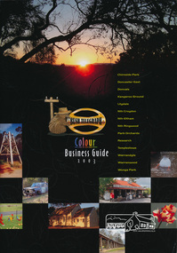
Book, Bush Telegraph Colour Business Guide 2003, 2003
Second publication following the success of the 2002 edition, aims to provide the local community with a comprehensive resource, promoting local businesses and services. This edition has broadened the demographic to include 14 suburbs.Soft cover book of colour display advertisements for business's located in Chirnside Park, Doncaster East, Donvale, Kangaroo Ground, Lilydale, Nth Croydon, Nth Eltham, Nth Ringwood, Park Orchards, Research, Templestowe, Warrandyte, Warranwood and Wonga Park areas arranged by category as listed in the contents page. Includes a sprinkling of historical images and brief descriptions of each area. Also includes lists of Child care, Churches, coming events and schools. 63 pagesbusiness directory, chirnside park, doncaster east, donvale, kangaroo ground, lilydale, nth croydon, nth eltham, nth ringwood, north eltham, park orchards, research (vic.), templestowe, warrandyte, warranwood, wonga park -
 Ithacan Historical Society
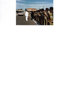
Photograph, Greek scouts Box Hill, c1970s
The Greek Community from the eastern suburbs of Melbourne established a scout group in Box Hill. The group functioned until the late 1980s. The photograph was taken when the Governor came to inspect the group. Sotiri Sikiotis, former Treasurer and Honorary Life Member of the Ithacan Philanthropic Society was actively involved in Melbourne's Greek scout movement and was on the committee of the first Melbourne 1st Greek Scout Group.A coloured photograph of a guard-of-honour comprising of a scout group being inspected by a visiting dignitary . -
 Bendigo Historical Society Inc.
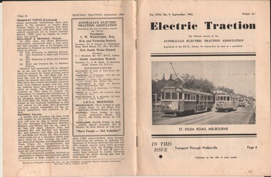
Document - BASIL MILLER COLLECTION: TRAMS - JOURNAL 'ELECTRIC TRACTION', September 1963
Journal of Australian Electric Traction Association. Volume XVII, No. 9, September 1963, 16 pages. History of document: Part of 'Basil Miller Tramways Collection'. Cover picture: most of the tram services to Melbourne's South Eastern suburbs operate along tree lined St. Kilda Road. W4 Class car 672 is about to pass four inbound cars in this road during the weekend of the Royal Visit earlier that year.Pub: Australian Electric Traction Asscn. Printer: O'Loughlin Bros. Pty. Ltd., Sydney, NSW.document -
 Bayside Gallery - Bayside City Council Art & Heritage Collection
Photograph, Department of Crown Lands and Survey, Victoria, Brighton, Elwood and Elsternwick, c. 1965-71
The Department of Crown Lands and Survey (1857-1983) was responsible for the administration of survey and mapping and the sale, occupation and management of crown land throughout its existence. This aerial photograph shows parts of Brighton, Elwood and Elsternwick and was taken circa 1965-71.brighton, department of crown lands and survey, aerial photograph, bayside, port phillip bay, map, cartographic material, elwood, elsternwick, elsternwick park, elwood tram depot, elwood pier, new street, glen huntly road, st kilda street, nepean highway