Showing 5515 items matching "boroondara"
-
 Kew Historical Society Inc
Archive (Sub-series) - Subject File, Kew Historical Society, Grip of Time, 1982
Various partiesReference, Research, InformationSecondary Values (KHS Imposed Order)Subject file containing both primary and secondary sources relating to the sculpture by Peter Schipperheyn (b.1955) - Grip of Time (1979) - installed on the north wall of the Kew Town Hall (now the Kew Library) in 1983. Mrs Laurel Abercrombie, a Kew resident, donated the sculpture to the City of Kew in 1982, and it formed part of the ‘municipal collection’ of the former City of Kew (now City of Boroondara). A note in the file records that prior to its installation on its current site; it was attached to a brick wall at the side of Abercrombie Galleries, Johnson Street, Collingwood. It was restored by the sculptor c.1996. The file contains two colour photographs of the sculpture and newspaper articles recording controversy at the time of its installation. The file also contains correspondence between the Society and the City of Boroondara relating to the plaque that was beside the sculpture.kew historical society - archives, kew library, kew civic hall, kew town hall, grip of time, peter schipperheyn (1955-), artworks - kew (vic), city of kew - municipal collectionkew historical society - archives, kew library, kew civic hall, kew town hall, grip of time, peter schipperheyn (1955-), artworks - kew (vic), city of kew - municipal collection -
 Kew Historical Society Inc
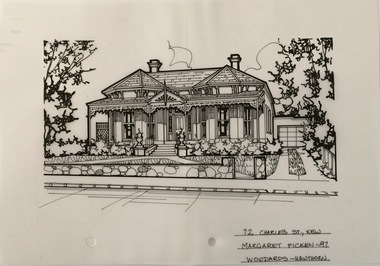
Drawing - Property Illustration, Margaret Picken, 72 Charles Street, Kew, 1997
After training as a Cartographic Draftsman within the mining industry, I worked as a property illustrator for real estate firms in the eastern suburbs of Melbourne for 23 years from 1983. I initially photographed houses with a Polaroid camera and made a 'thumbnail' sketch while there. The photos were used to scale off a sketch in pencil and then that sketch was overlaid with drafting film and the 'pen and ink' completed. The pens I used were the Rotring ‘Rapidigraph’ drafting pens. The ink was also made by Rotring (German).The film was ‘Rapidraw’, polyester drafting film, double matte. It takes a very fine line and doesn’t bleed. As well as house sketches, there were often floor plans and site plans ordered. Aerial sketches were ordered when the property needed an overall view. (Margaret Picken, 2020)This drawing is one of a series created by Margaret Picken for a range of real estate agents in Melbourne between c.1983 and c.2005. Each work is signed and dated by the artist.Gift of Margaret Picken, 2020Victorian villa of Hawthorn brick. Built in 1890 and with Grade B heritage listing by the City of Boroondara. Rear additions and alterations in 1999. Replacement verandah roof and floor in 2020. Stone fence has been replaced with a palisade fence. The pen and ink architectural drawing on drafting film of 72 Charles Street, Kew was made by Margaret Picken in 1997.72 CHARLES ST., KEW / MARGARET PICKEN ~97 / WOODARDS ~ HAWTHORNartist -- margaret picken 1950-, architectural drawings -- houses -- kew (vic.), 72 charles street -- kew (vic.) -
 Kew Historical Society Inc
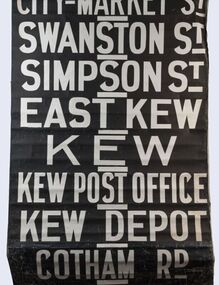
Functional object - Destination Roll, Melbourne & Metropolitan Tramways Board, 1960s
In an era predating the computerisation of equipment on public transport, where trams in Melbourne were driven by drivers and conductors sold fares, destinations were shown at the front and rear of the tram within a glazed box. A driver adjusted the roll to select each new trip destination. Given the length of rolls, in this case approximately nine metres, this could be a time consuming process. In addition to the named destination roll, each tram included a separate roll listing the route numbers.The roll was purchased at a Leski Auction in Armadale as part of a large group of tramways memorabilia including tram 'rolls' from New South Wales, Victoria, South Australia and Tasmania. The auction house described the collection as "The collection of destination blinds or rolls that forms the core of the Railways Trams & Buses Section (Lots 655 – 732) is the best we have ever offered and represents a life-time of collecting by an Adelaide enthusiast, now deceased." Melbourne & Metropolitan Tramways Board Tramways Destination Roll. Black and white paint on linen roll. Forty-eight named destinations including four depots - Camberwell, Hanna Street, Hawthorn, Kew. Multiple destinations in what is now the City of Boroondara (Kew, Hawthorn and Camberwell); including East Kew, Kew, Kew Post Office, Kew Depot, and Cotham Road.Named destinations beginning to end: “Olympic Park / Special / Football / Racecourse / Richmond / Burnley / Riversdale / Wattle Park - Warragul Rd / Wattle Park - Elgar Rd / City / Burwood / Hartwell / Bowen St / Camberwell Depot / Camberwell Jucn / Leura Grove / Gardener / Glenferrie Rd / Chapel St / St Kilda Rd / Camberwell / City / Lonsdale St / University / City via William St / Domain Rd / Hanna St Depot / South Melb & St Kilda Beach / Prahran / North Richmond / Windsor / Hawthorn Depot / Hawthorn / Spencer St / Toorak Rd / Swan & Church St Cnr / North Balwyn / City Flinders & Spencer Sts Corner / City - Market St / Swanston St / Simpson St / East Kew / Kew / Kew Post Office / Kew Depot / Cotham Rd / Malv Tn Hall"melbourne & metropolitan tramways board -
Kew Historical Society Inc
Archive (Sub-series) - Subject File, Kew Historical Society, Gallipoli & Beyond 2015, 2014
Boroondara Historical Societies AssociationReference, Research, InformationProvenance orderGallipoli & Beyond was a Commonwealth funded project involving members of the Boroondara Historical Societies Association. The project involved roadshow, exhibitions, talks, and the publication of a history. The file contains newspaper and magazine, articles/clippings, promotional materials, certificates, etc. The Kew Historical Society participated in a number of events and held an exhibition on the embarkation photographs of Josiah Earl Barnes. The captions and the posters are held separately in the map drawers.photographers - kew (vic) - josiah earl barnes, first world war, boroondara historical societies association (bhsa), gallipoli & beyond - special projects, wwiphotographers - kew (vic) - josiah earl barnes, first world war, boroondara historical societies association (bhsa), gallipoli & beyond - special projects, wwi -
Surrey Hills Historical Society Collection
Work on paper - Vertical file, Athletics
A vertical file containing information related to athletics clubs and competition in Surrey Hills and Mont Albert: 1. Athletic club – Surrey Hills: 6 notes from Boroondara Standard, various dates (2 pages). 2. Excerpts from Box Hill Reporter, various dates; Ken James research (18 pages). This represents part of Ken's research into clubs and societies of the area.athletics, ken james -
 Melbourne Tram Museum
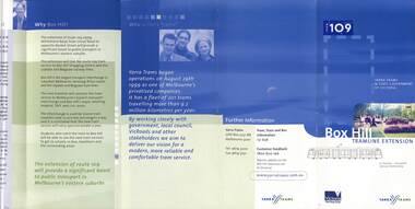
Pamphlet, VicRoads, "Have your say on improving tram 109", Sep. 2005
Pamphlet or book - 12 pages, A4 landscape printed on gloss white paper, centre stapled, titled "Have your say on improving tram 109", consultative or consultation document for the Box Hill tram route. Gives information and consultative meetings - looks at the relocation and reconstruction of tram stops, centre platform stops, kerb access stops, maps and alternative stop locations from Kew Junction to Union Road - stops within the City of Boroondara. Contains a form that could be posted back to VicRoads. Published 9/2005c, has dates for October 2005 meetings. Has the logos of Victorian Government, VicRoads, Yarra Trams and the City of Boroondara. Two copies held .1 - five fold pamphlet - DL - titled "Box Hill Tram line extension", promoting the construction of the route 109 to Box Hill. Message from the Minister, Peter Batchelor, who is Yarra Trams, project details, benefits and why.trams, tramways, yarra trams, route 109, box hill, mont albert, kew junction, superstops, tram stops, city of boroondara, vicroads, new tramway, construction -
 Kew Historical Society Inc
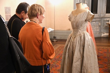
Exhibition: Fashion in the Age of Elegance 1840-1900 [Series 2], 2023
The Kew Historical Society holds a nationally significant Fashion & Design collection. In 2023 this collection was augmented by a donation by descendants of Francis Henty of nineteenth and early twentieth century costumes and costume accessories. These rare and aesthetically significant acquisitions increased the importance of the nineteenth century costume collection held by the Society. Following their accession, the Henty costumes were exhibited with other notable examples of fashion and design, previously donated by descendants of the Coombs and Weir families.7 x Photos of the opening night of Fashion in the Age of Elegance 1840-1900, held at Villa Alba Museum during the 2023 Australian Heritage Festival. The exhibition showcased items drawn from the Henty, Coombs and Weir Collections. Guests included members of Kew Historical Society, Villa Alba Museum, Heidelberg Historical Society, Royal Historical Society of Victoria, Museums Victoria, City of Boroondara, and National Gallery of Victoria. fashion -- nineteenth century, exhibitions -- kew historical society, henty collection, coombs collection, weir collection -
 Melbourne Tram Museum
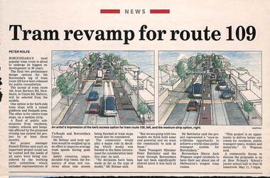
Newspaper, Progress Press, "Tram revamp for route 109", 10/05/2004 12:00:00 AM
Newspaper clipping - from The Progress Press, 10 May 2004, titled "Tram revamp for route 109" looking at different types of tram stops for the section of Route 109 between Barkers Road Hawthorn and Union Road Balwyn. Quotes the Transport Minister Peter Bachelor, Project Manager Russell Bittner and Boroondara Mayor Jack Wegman. Item by Peter Rolfe, has images of proposed stops. This did not occur.trams, tramways, route 109, tram stops, whitehorse rd, city of boroondara -
 Kew Historical Society Inc
Plan - Subdivision Plan, J R Mathers & McMillan, Clutha Subdivision, 1940
Pru Sanderson, in her groundbreaking ‘City of Kew Urban Conservation Study : Volume 2 - Development History’ (1988), summarised the periods of urban development and subdivisions of land in Kew. The periods that she identified included 1845-1880, 1880-1893, 1893-1921, 1921-1933, 1933-1943, and Post-War Development. These periods were selected as they represented periods of rapid growth or decline in urban development. An obvious starting point for Sanderson’s groupings involved population growth and the associated economic cycles. These cycles also highlighted urban expansion onto land that was predominantly rural, although in other cases it represented the decline and breakup of large estates. A number of the plans in the Kew Historical Society’s collection can also be found in other collections, such as those of the State Library of Victoria and the Boroondara Library Service. A number are however unique to the collection.The Kew Historical Society collection includes almost 100 subdivision plans pertaining to suburbs of the City of Melbourne. Most of these are of Kew, Kew East or Studley Park, although a smaller number are plans of Camberwell, Deepdene, Balwyn and Hawthorn. It is believed that the majority of the plans were gifted to the Society by persons connected with the real estate firm - J. R. Mathers and McMillan, 136 Cotham Road, Kew. The Plans in the collection are rarely in pristine form, being working plans on which the agent would write notes and record lots sold and the prices of these. The subdivision plans are historically significant examples of the growth of urban Melbourne from the beginning of the 20th Century up until the 1980s. A number of the plans are double-sided and often include a photograph on the reverse. A number of the latter are by noted photographers such as J.E. Barnes.The subdivision plan for the Clutha Subdivision is one of the largest in the Society’s collection. The plan includes a map of the proposed allotments, photographic views to the north and south, and information about the kinds of buildings that could be constructed on the allotments. The subdivision was bounded by Studley Park Road, and Carson, Stevenson and Edgecombe Streets. Two new streets, Mackie Court and Younger Street were created as part of the subdivision. The subdivision took its name from ‘Clutha’, the home of John Carson, who was to become Mayor of Kew in 1863. A Report to the City of Boroondara outlined how: ‘The Clutha estate was progressively developed from 1940, with new houses under construction on the Studley Park Road, Carson and Edgecombe Street frontages by 1941. By 1943, directory listings were available for all addresses with the exception of Mackie Court. Building ceased after the government’s prohibition on civilian building was enforced from 1942, with little change in listings until the 1950s when the remainder of the subdivision was developed’."H"subdivisions - kew - studley park, clutha subdivision, studley park road -
 Kew Historical Society Inc
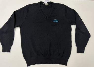
Uniform - Kew Library Uniform : long sleeve jumper
The Kew Library was run by the City of Kew until it was amalgamated into the Boroondara Library Service, when Kew became part of the City of Boroondara in 1994.Black Kew Library woollen long sleeve jumper with the name of the library embroidered in acqua thread. This black jumper was part of a new colour scheme, superseding the previous royal blue uniforms."Kew Library"library uniforms, kew library, jumpers, clothing -
 Kew Historical Society Inc
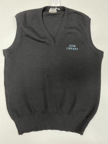
Uniform - Kew Library Uniform : sleeveless jumper
The Kew Library was run by the City of Kew until it was amalgamated into the Boroondara Library Service, when Kew became part of the City of Boroondara in 1994.Black Kew Library woollen sleeveless jumper with the name of the library embroidered in acqua thread. This black jumper was part of a new colour scheme, superseding the previous royal blue uniforms."Kew Library"library uniforms, kew library, jumpers, clothing -
 Kew Historical Society Inc
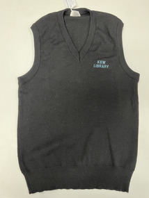
Uniform - Kew Library Uniform : sleeveless jumper
The Kew Library was run by the City of Kew until it was amalgamated into the Boroondara Library Service, when Kew became part of the City of Boroondara in 1994.Black Kew Library woollen sleeveless jumper with the name of the library embroidered in acqua thread. This black jumper was part of a new colour scheme, superseding the previous royal blue uniforms."Kew Library"library uniforms, kew library, jumpers, clothing -
 Kew Historical Society Inc
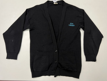
Uniform - Kew Library Uniform : cardigan
The Kew Library was run by the City of Kew until it was amalgamated into the Boroondara Library Service, when Kew became part of the City of Boroondara in 1994.Black Kew Library woollen cardigan with the name of the library embroidered in acqua thread. This black jumper was part of a new colour scheme, superseding the previous royal blue uniforms."Kew Library"library uniforms, cardigans, kew library -
 Kew Historical Society Inc
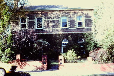
Slide - 4 Selbourne Road, Kew, 1979
One of a group of slides taken by members of the Society of built heritage in Kew in 1979-80. The selection of subject matter reflects the priorities of the period. The colour of some slides has degraded.The slides represent a snapshot in time of built architecture in Kew, much of which has changed in the forty-plus period since they were created.Colour positive transparency (slide) of 4 Selbourne Road, Kew, the former home of Sir Wilfred Kent-Hughes (1895-1970) who was the State Member for Kew from 1927-1949. Subsequently he was elected to the Federal Parliament as the Member for Chisholm. The two-storey, double fronted, polychrome brick house is within the City of Boroondara's Glenferrie Road Precinct, which includes a number of individually significant architectural designs, the majority of which are Victorian mansions.historic houses -- kew (vic.), 4 selbourne road -- kew (vic.), sir wilfred kent-hughes -
 Surrey Hills Historical Society Collection
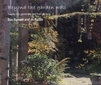
book, Beyond the garden wall: twenty-two gardeners and their gardens, 2008
This book was compiled by Sue Barnett at the request of the project participants from material gathered as part of the project "Beyond the Garden Wall". This project was devised and managed by a team at Surrey Hills Neighbourhood Centre Inc. with funding from the Victorian Department of Planning and Community Development (VDPCD) under the "Images of Age' grant 2007. It involved conducting oral histories, reflection on the part of the participants through visual diaries, photography and painting. A short video of some of the gardens was also commissioned. All the elements came together during Seniors Festival in an exhibition held at the Augustine Centre, and opened by Jane Edmanson. At the request of the VDPCD, a modified exhibition was held in 2008 at 'Australia on Collins' during the 2008 Seniors Festival. Sue Barnett and Jo Reitze (Mrs de Carteret) are Surrey Hills residents. This provides a snapshot of 20 gardens and the 22 passionate gardeners who created them. The prose provides a potted history of the gardeners and their philosophical approach, accompanied by portraits of them and cameo photos of their gardens, as well as a photo of the painting of the garden as seen by artist Jo Reitze. All the gardens were situated within the City of Boroondara and all the gardeners were over 60 years of age. Prose written by Sue Barnett; photography by Sue Barnett and Jo Reitze.gardening, anecdotes, (ms) jo reitze, (ms) susan barnett, sue barnett, paintings, gardeners -
Camberwell Historical Society
Poster (Item), Australian National Song
Taken from: Poulton, F. & Sheedy K. (2015) Boroondara Remembers. Stories from World War 1. City of Boroondara; Barnett, S. (2015) Personal communication.australia, military, national -
 Kew Historical Society Inc
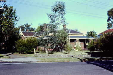
Slide - Villa, 16 Redmond Street, 1979
One of a group of slides taken by members of the Society of built heritage in Kew in 1979-80. The selection of subject matter reflects the priorities of the period. The colour of some slides has degraded.The slides represent a snapshot in time of built architecture in Kew, much of which has changed in the forty-plus period since they were created.Colour positive transparency (slide) of a single-storey Victorian tuck-pointed polychrome villa (formerly known as 'Roylands', 'Myrambeek') on the corner of Redmond and Fellows Streets, Kew. Research by Lovell Chen established that the house was built in 1892-3 and that owners have included Charles Bennett, Zilpah Bennett, Catherine Bucknall, Frederick Umber, George Darby etc. The 2014 report recommended that the house be included in the Schedule to the Heritage Overlay of the Boroondara Planning Scheme as an individually Significant place."Cnr Redmond and Fellows Streets"historic houses -- kew (vic.), victorian villas -- kew (vic.), 16 redmond street -- kew (vic.), roylands, myrambeek -
Canterbury History Group
Document - Boroondara voters 1870 and 1880
handwritten notes on voters for BoroondaraA4 sheetelectoral rolls, canterbury -
Kew Historical Society Inc
Archive (Series) - Subject File, Kew Historical Society, Hawthorn (Vic) - History, 1958
Various partiesReference, Research, InformationSecondary Values (KHS Imposed Order)Subject file containing typescripts relating to the early history of Hawthorn. The files were donated to the Society from the Preshil School archives. Some of the files were subsequently moved to other files or archive boxes including ‘Maps of Kew’ (archive file) and the newspaper collection (boxed newspapers). The files currently stored in this archive file include: Allen, J Alex, ‘The Red Lion Inn and Early Hawthorn’ (RHSV 1946), Serpell, TE, ‘Early History of Hawthorn’ (5pp), and Bonwick, J, ‘A Sketch of Boroondara’ (1858).hawthorn - history - 19th century, red lion inn, james bonwickhawthorn - history - 19th century, red lion inn, james bonwick -
 Melbourne Tram Museum
Map, Metlink, "City of Moonee Valley - Local Travel Guide - July 2008", Sep. 2008
Map, Guide book, Pamphlet, 21 fold, pocket size, titled "City of Moonee Valley - Local Travel Guide - July 2008" detailing public transport services in the City. Includes map of the tram, train networks, tickets information, tram traction , Connex SMS updates and info on Metlink including contact details. Has a detail map showing services in the city and adjacent overlap area of buses, trams and trains including route numbers. See Reg Item 2250 for City of Boroondara version.trams, tramways, city of moonee valley, map, guides, bus services, metlink, connex -
 Kew Historical Society Inc
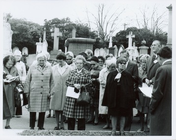
Photograph - Tour of the Boroondara (Kew) General Cemetery, 1977
Boroondara Cemetery, established in 1858, is within an unusual triangular reserve bounded by High Street, Park Hill Road and Victoria Park, Kew. By the 1890s, the Boroondara Cemetery was a popular destination for visitors and locals admiring the beauty of the grounds and the splendid monuments. The Boroondara Cemetery is of historical significance for the graves, monuments and epitaphs of a number of individuals whose activities have played a major part in Australia's history. They include the Henty family, artists Louis Buvelot and Charles Nuttall, businessmen John Halfey and publisher David Syme, artist and diarist Georgiana McCrae, actress Nellie Stewart and architect and designer of the Boroondara and Melbourne General Cemeteries, Albert Purchas.Walking tour led by Kew Historical Society members for members of the Royal Historical Society of Victoria in 1977. The photograph shows members of both parties assembled at a grave in the Cemetery. The photograph was one of six taken by KHS member Stewart West on that occasion, and subsequently donated by him to the collection by him.Reverse: "Front row in dark coat and glasses - Mrs Mills, With dark glasses reading - Mrs Ekberg (KHS member); Second from right Mr Slattery then president of Society; Far left Miss B Mackie (KHS member)" boroondara general cemetery, kew cemetery, walking tours -
 Kew Historical Society Inc
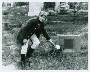
Photograph - Tour of the Boroondara (Kew) General Cemetery, 1977
Boroondara Cemetery, established in 1858, is within an unusual triangular reserve bounded by High Street, Park Hill Road and Victoria Park, Kew. By the 1890s, the Boroondara Cemetery was a popular destination for visitors and locals admiring the beauty of the grounds and the splendid monuments. The Boroondara Cemetery is of historical significance for the graves, monuments and epitaphs of a number of individuals whose activities have played a major part in Australia's history. They include the Henty family, artists Louis Buvelot and Charles Nuttall, businessmen John Halfey and publisher David Syme, artist and diarist Georgiana McCrae, actress Nellie Stewart and architect and designer of the Boroondara and Melbourne General Cemeteries, Albert Purchas.Walking tour led by Kew Historical Society members for members of the Royal Historical Society of Victoria in 1977. The photograph shows a Kew youth placing a sprig of Rosemary on Ellen Quick's grave. The photograph was one of six taken by KHS member Stewart West on that occasion, and subsequently donated by him to the collection by him.Reverse: "Kew youth placing a sprig of rosemary on grave of Ellen Quick nee Derrick who was the first burial on 12/3/1859. Her family Derricks were early Kew Landowners." boroondara general cemetery, kew cemetery, walking tours, ellen quick, dannock family, kew pioneers -
Kew Historical Society Inc
Archive (series) - Subject File, Barkers Road, 1953
Various PartiesReference, Research, InformationKHS OrderSubject file with multiple items of research relating to the history of Barkers Road, previously Barkers Track (sic) including: 2 copies of ‘Barkers Track: Recollections of the Hawthorn Kew Boundary’ (Typescript, Mervyn Chinner, undated, 4pp), ‘The Boroondara Family Hotel’ (Photocopied typescript, 1987, 10pp), ‘Barkers Road (Gwen McWilliam, 1976), a photocopy of an ADB entry on BARKER, Edward (1816-1885). The file also includes a typed letter to Mrs Dickins from Cr WHS Dickinson (1953) relating to the state of Barkers Road and sundry newspaper clippings/articles.barkers road - kew (vic.), barkers track - kew - hawthornbarkers road - kew (vic.), barkers track - kew - hawthorn -
Canterbury History Group
Document - Thematic Environmental History, Built Heritage, 1/05/2012
Thematic Environmental Heritage. Final document produced, after community consultation, for the City of Boroondara by Built Heritage242 pages city of boroondara, back yards, canterbury, churches, cottages, dairies, danks family, elgar survey, exploration, frognall, goldings boot factory, maling road, malone's hotel, maps, masonic lodges, national parks, native plants, outer circle railway line, police stations, post offices, railways, rochester road, schools, shrublands, soldiers memorial hall, sport, telephone exchanges, theatres, transport, wildlife, canterbury road, land subdivisions, parks and reserves -
![Public Works, Barry Street [Kew], 1955](/media/collectors/550653872162f11fb04854aa/items/586f97ffd0ce2307f0beee65/item-media/586f985ed0ce2307f0bf0aa6/item-fit-380x285.jpg) Kew Historical Society Inc
Kew Historical Society IncPhotograph, City of Kew, Public Works, Barry Street [Kew], 1955, 1955
Original photograph donated to the Kew Historical Society by the City's Engineering Department before the amalgamation of Kew into the City of Boroondara in 1994.This 1955 photograph provides a fine snapshot of the work of local government engineering departments in the 1950s. They reveal they types of labour conducted, the techniques used and the equipment and machinery in the possession of the local government authority.Trees in Barry Street, Kew. Barry Street, Kew, looking south to the intersection of Stawell Street. Inscription [pencil] B1955. Stamped: "Please quote No. Gx2320 when ordering. Laurie Richards JW 1528"barry street (kew), gutters, nature strips, street trees -
 Kew Historical Society Inc
Photograph, City of Kew, Public Works, Road Making, c.1920s
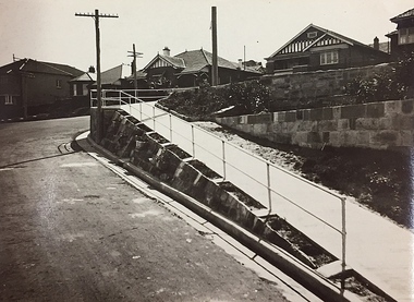
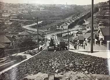
An original photograph donated to the Kew Historical Society by the City's Engineering Department before the amalgamation of Kew into the City of Boroondara in 1994. While not all of the photographs are of Studley Park, Kew or East Kew, each photo provides a fine snapshot of the work of local government engineering departments of the period. They reveal they types of labour conducted, the techniques used and the equipment and machinery in the possession of the local government authority.Public works. A high retaining wall holds back an embankment on a steep slope around which a road turns. It is believed that the photograph dates from the 1920s. Inscription on reverse: "A difficult corner designed to obviate the use of steps. / Pedestrians using the road in front of the dwellings step off the pathway at the telegraph pole".city of kew (engineering department), engineering, road construction building -
 Kew Historical Society Inc
Photograph, City of Kew, Public Works, Road Construction, c. 1920s
An original photograph donated to the Kew Historical Society by the City's Engineering Department before the amalgamation of Kew into the City of Boroondara in 1994. While not all of the photographs are of Studley Park, Kew or East Kew, each photo provides a fine snapshot of the work of local government engineering departments of the period. They reveal they types of labour conducted, the techniques used and the equipment and machinery in the possession of the local government authority. Public works. A photograph of a suburban street under construction using a steamroller. The street was photographed to demonstrate the issues relating to grading. Neither the street nor the location has been identified. Inscription on reverse: "The construction of a roadway in a 1 in 3 1/2 grade. / The waggon is hauling the roller, by means of a cable attached to a pulley anchored at the top of the grade." engineering, city of kew (engineering department), road making construction -
 Kew Historical Society Inc
Photograph, City of Kew, Public Works, Road Construction, c.1920s
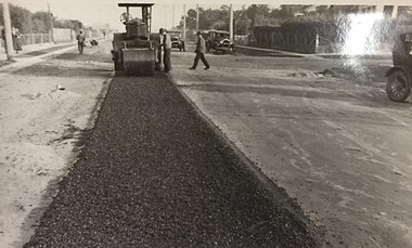
An original photograph donated to the Kew Historical Society by the City's Engineering Department before the amalgamation of Kew into the City of Boroondara in 1994.While not all of the photographs are of Studley Park, Kew or East Kew, each photo provides a fine snapshot of the work of local government engineering departments of the period. They reveal they types of labour conducted, the techniques used and the equipment and machinery in the possession of the local government authority. Public works. A photograph of a suburban street under construction using a steamroller. Neither the street nor the location has been identified. It is believed that the photograph can be dated to the 1920s. Inscription on reverse: "Road making. (?1920s cars)".steamroller, road construction building, city of kew, city of kew (engineering department) -
 Kew Historical Society Inc
Photograph, City of Kew, Public Works, Road Construction, c.1920s
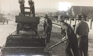
An original photograph donated to the Kew Historical Society by the City's Engineering Department before the amalgamation of Kew into the City of Boroondara in 1994.While not all of the photographs are of Studley Park, Kew or East Kew, each photo provides a fine snapshot of the work of local government engineering departments of the period. They reveal they types of labour conducted, the techniques used and the equipment and machinery in the possession of the local government authority. Public works. A close-up photograph of a grader being pulled by a truck. road construction building, city of kew, city of kew (engineering department), bituminising, grader