Showing 378 items matching "north court"
-
 Public Record Office Victoria
Despatch, 28 February 1855
VA 466 Governor (including Lieutenant Governor 1851-1855 and Governor's Office)Eureka Stockade:Charles Hotham reporting the result of the trial of two of the Ballaarat rioters, at the Supreme Courttrial -
Public Record Office Victoria
Court Record, 1855
VA 475 Chief Secretary's DepartmentEureka Stockade:Goodenough's testimonytrial -
 Public Record Office Victoria
Court Record, 17 January 1855
VA 475 Chief Secretary's DepartmentEureka Stockade:Proceedings of the Supreme Court in the matter of Queen v. Hayes and otherstrial, supreme court, eureka, eureka stockade -
Public Record Office Victoria
Legal record (item) - Divorce Papers for Frank Paice and Florence Paice (otherwise Cox)
A file previously held in the collection of the Supreme Court of Victoria and now in Public Record Office Victoria contains records of the annulment of the marriage of Florence Cox in 1919. As the earliest known record of a person with intersex variations in Victorian history, Cox’s story – and this record – are of unique historical significance to the LGBTIQ+ history of the State. Florence Cox (1887–1950) had a middle-class upbringing in Melbourne. In 1914 she travelled to Bengal to marry her fiancé Frank Paice and to join him in his missionary work for the Baptist church. The couple returned to Melbourne in 1918 and the following year the Supreme Court of Victoria, at Paice’s request, annulled their marriage. The Supreme Court file reveals that Paice declared he had been unable to consummate the marriage, due to ‘a malformation frigidity or other defect of the parts of generation’ of his wife. Both Paice and Cox were subject to medical examination, which established that Cox had what is recognised today as the intersex condition complete androgen insensitivity syndrome. The court determined that marital intercourse, as it was understood at the time, was impossible for Paice and Cox, and granted the request for an annulment. Paice remarried, fathered children and led a successful professional and civic life, serving a period as Mayor of Nunawading, in the middle- class eastern suburbs of Melbourne. Cox’s life was very different. It is unlikely that anyone in her life would have known what had prompted the end of the marriage, but gossip would certainly have focussed on her part in it. She never remarried and, although she remained connected to her family, her story was rarely discussed. Cox was admitted to Mont Park Mental Hospital in Melbourne’s northern suburbs in 1945, where she died five years later. The Supreme Court file preserves one of the most detailed medical descriptions of a person with intersex variations from that period. It is particularly striking that following the court case, the file was closed ‘forever’. This indicates how seriously the court took the case, and its determination to protect Cox and Paice from public scrutiny. It speaks loudly to the thinking of the time on a matter that was rarely, if ever, raised in public. In 1997, Cox’s great-nephew Ian Richardson set out to investigate the secrecy surrounding his great-aunt Florrie. Following a relentless, two-year campaign by Richardson and other descendants of Cox and Paice, the Supreme Court file was finally opened to the public. Richardson’s book, God’s Triangle, recounts his quest and brings Cox’s story out of the archives and into the light. Quoted from "A History of LGBTIQ+ Victoria in 100 Places and Objects" by Graham Willett, Angela Bailey, Timothy W. Jones and Sarah Rood. -
 Melton City Libraries
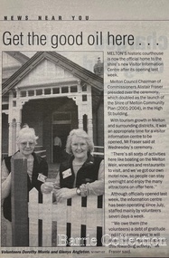
Newspaper, Get the good oil here…, 2001
"A court was established in Melton by 1864, when the first recorded case was heard before Mr BA Porter JP, with Mr A Carroll as the Clerk of Courts. John James was convicted of being drunk, for which he was fined five shillings or 24 hours imprisonment. The court was held in the ‘long room’ of the old Melton Hotel, before moving to rented accommodation at the Raglan Hotel, and finally to the Roads Board office. Tenders for construction of the present building were called for by the Public Works Department on 13th February 1892. The architect Samuel Edward Brindley was born in Birmingham, England, in 1842. He was articled to the local architect, J.R. Botham, FRIBA, before emigrating to Victoria where he was employed as an architect in the Education Department from 18 August 1873. With the amalgamation of the architectural branch of the Education Department with the Public Works Department in 1884, Bindley was placed in charge of Victorian government building design for the North-Western District. In 1975, the Melton and District Historical Society became concerned at hearsay that the court house was to be demolished to make way for carparking space. Melton had been declared a ‘satellite city’ and was developing rapidly. A new shopping centre had recently been built at a setback of 60 feet (c.18 metre) from 323-329 High Street, and the court house, together with the adjacent weatherboard police station, had been left standing alone. A new police station was planned, and the weatherboard police station was subsequently demolished. In its nomination of the building for National Trust classification the Society argued that the Court House was ‘the best of two early buildings left in the main street’ (the other being a bluestone hotel) and that its loss would be ‘tragic’. However the nomination was unsuccessful, the National Trust at the time judging that it was of no particular ‘distinction’ or ‘antiquity’. The building continued to be used as a court house at least until 1991 when the Department of Housing and Construction (formerly the PWD) conducted a heritage study of court houses. By this time Federation-era architecture had achieved acceptance within the heritage movement. The building was recognised as being ‘the only surviving example in brick of the Federation Queen Anne style which was used for court houses only twice.’ Twenty years later when it was proposed to modify the eastern façade of the building to accommodate a café, the M&DHS was again concerned. This time the National Trust objected that the proposed extension would be an over-development of the site, and questioned the changes to the interior court room furnishings and fittings. The site never appears to have been nominated to the Victorian Heritage Register. It has since been converted into the Shire of Melton Tourist Information Centre". Opening of the Visitor Centre in Meltoncouncil, local architecture -
Friends of Ballarat Botanical Gardens History Group
Work on paper - Richard Armstrong Crouch. 1868-1949. Last Will and Testament, Benefactor - Prime Ministers' Avenue, Ballarat Botanical Gardens, 30/10/1948 and 8/12/1949
R.A.Crouch made this Will the year before he died.R.A. Crouch became famous especially for his endowment to the Prime Ministers' Avenue.3 typed pages; copy grey at the bottom of each page. p.1 bottom of page, dated 30/10/1948. pp.2&3 Inventory of Assets.Signed R.A.Crouch and in longhand below, Jean, Elva, Honey and then an illegible signature. pp 2&3, Heading "In the Supreme Court dated 8/12/1949 and witnessed.john garner, doctor, richard alexander crouch, ballarat botanical gardens, prime ministers' avenue, prime ministers' busts, ballarat art gallery, solicitor, soldier, politician, benefactor., crouch, john garner collection, gardens, ballarat -
 Mont De Lancey
Book, E.W. Cole, Sketches by Boz
Charles Dickens' first published book, Sketches by Boz is a funny and touching observation, fancy and fiction showing the London he knew in all its complexity - its streets, theatres, inns, pawnshops law courts, prisons and of course the river Thames.A small faded green hardback novel, The Sketches of Boz by Charles Dickens. The front cover has no title but the spine has faded gold lettering of the title, author and publisher as well as decorative symbol. 558p.At the front is a page with an inscription in black ink handwriting and a date.fiction Charles Dickens' first published book, Sketches by Boz is a funny and touching observation, fancy and fiction showing the London he knew in all its complexity - its streets, theatres, inns, pawnshops law courts, prisons and of course the river Thames.books, fiction books, historical fiction -
 Mont De Lancey
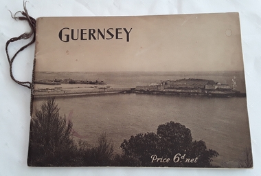
Booklet, The Star and Gazette Company Ltd, The Bailiwick of Guernsey, 1921
A historical descriptive booklet describing the charms and amenities of the wonderful island of Guernsey and all it has to offer. It includes archaeology, schools and colleges, churches, yachting, agriculture, sports, the growing industry. It has small sections on Alderney and Sark.A slim rectangular brown toned softcover booklet with Guernsey printed in black lettering at the top of the front cover and Price 6d. net printed in white lettering at the bottom right. The front and back covers depict a large overall scene of Guernsey from the land looking over the water. The Bailiwick of Guernsey: (The Islands of Guernsey, Alderney and Sark) is printed on the title page with a sepia coloured photograph of the reception of their majesties the King and Queen, and Princess Mary on the occasion of their visit, July11, 1921. There are many black and white photographs throughout the booklet. It has brown thin cord tied on the spine. 24p.non-fictionA historical descriptive booklet describing the charms and amenities of the wonderful island of Guernsey and all it has to offer. It includes archaeology, schools and colleges, churches, yachting, agriculture, sports, the growing industry. It has small sections on Alderney and Sark.history booklet, guernsey history -
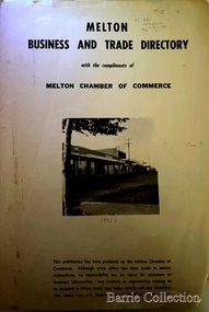 Melton City Libraries
Booklet, Melton Business and Trade Directory, c.1965
BUSINESS TRADE AND DIRECTORY MAP NORTH of High Street RALIEGHS Road - Early settlers Oliver Reierson ( Norwegian) Raliegh SHEBLER Court Auguste EMIL Court Jongebloed Family residence “Hemlich” ALEXANDRA Street Coronation King, Queen Alexandra - 1903 O’NEILS Road Farmer OLDERSHAW Road CORR Grove Early landowner, Teacher at the Common School – Denominational Churches, 1850’s Wesleyan (Methodist) BRYAN Court 1850’s resident renamed from earliest town site - Flat HURLEY Street Early settler and farmers - CHESNEY Road was named Minns, due to duplication altered to Chesney (Minns) SOUTH of High ALKEMADE Drive. Family name ARNOLD Court Family BARRIES Road Charles Ernest Barrie “Darlingsford” 1911 Residence KILPATRICKS Road became Barries Road west of Station Road BLACKWOOD Drive Alexander, Early settler CALLANAN Drive Surveyor early LUBY Court John Luby - Crown Grant Land title KERWIN Street Michael - Crown Grant land title (deleted due to Freeway)Pamphlet of Melton Businesses and map of the townlocal identities, misc., council -
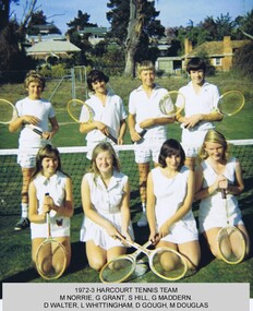 Harcourt Valley Heritage & Tourist Centre
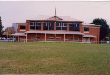
Tennis Club Photograph, Harcourt Tennis Club, 1973
Tennis was first played at Harcourt North at the "Brooks Tennis Courts" and as it increased in popularity a team commenced playing at courts at the corner of High and Market Sts Harcourt in the early 1900s. At one time it was known as the Alexander Tennis Club.New courts at the football oval in Bridge Street were eventually replaced by courts at the new oval at Binghams Road, Harcourt. The Harcourt teams play in the Castlemaine District Lawn Tennis Association competition. This team shot, chosen at random from our holdings, depicts young players of both sexes.Tennis has proven to be a great social game involving a high proportion of women and young people in the competition.Colour Photograph of the 1972/3 Harcourt tennis teamHarcourt Tennis Club -
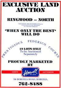 Ringwood and District Historical Society
Pamphlet, Land Auction Brochure - Federico Courts Estate, Ringwood North, Vic. Circa 1988
... - Federico Courts Estate, Ringwood North, Vic. Circa 1988 Pamphlet ...Bifold brochure advertising auction of 19 residential allotments on Saturday 15th October, (1988?). Brochure includes terms of sale, description of subdivision features and local facilities, with locality map. Subdivision includes Federico Court and Gilston Way, Ringwood North. Agents/Auctioneers - B.S. Howell Real Estate, 94 Boronia Road, Boronia, (Phone) 762 8488. -
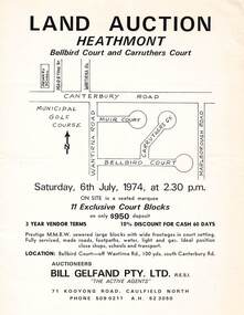 Ringwood and District Historical Society
Flyer - Land Auction, Carruthers Estate, Heathmont, Victoria - 1974
Double-sided page advertising auction of 11 allotments on Saturday, 6th July, 1974, with locality map and plan of subdivision in Carruthers Court and Bellbird Court, Heathmont. $950 deposit, 3 year vendor terms, 10% discount for cash 60 days. Handwritten notation indicating Lot 22 "sold for $127,000 - all other lots passed in around $11,000".Auctioneers - Bill Gelfand Pty. Ltd., R.E.S.I. 71 Kooyong Road, Caulfield North, Phone 5090211 A.H. 523050. -
 Federation University Historical Collection
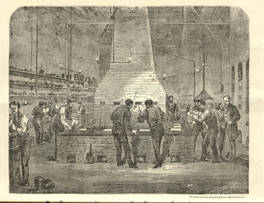
Booklet, The School of Mines Ballarat: A Statement of the Objects and Present Resources of the School, 1873, 1873
The Ballarat School of Mines was the first School of Mines in Australia and was established in 1870. 22 page booklet titles 'The Ballarat School of Mines: A Statement of the Objects and Resources of the School.' The book has a number of illustrations including the interior of the Ballarat School of Mines Laboratory, and the former Ballarat Circuit Court House. It includes a statement of the formation, progress, and present position of the School of Mines, Ballaarat. The image of the Ballarat School Mines Assay Room shows assay furnaces, crucibles, chimney, and teacher Joseph Flude on the far right. This room is now is a building known as the 'Old Chemistry Building'. Plan and elevation of the new Metallurgical Laboratory and Proposed Chemical Laboratory is depicted.On front cover "Recorded in M-A" "1873"ballarat school of mines, assay, courthouse, joseph flude, crucible, furnace, flude, warrington rogers, brough smyth, harrie wood, wood, james bickett, bickett, redmond barry, somerville learmonth, metallurgy, chemistry, laboratory, examinations, mining engineer, assayer, inorganic chemistry, underground managers, captains of shift, engieners, enginedrivers, louis balhausen, james campbell, l.s. christie, j.j. casey, alexander dempster, g. higinbotham, james martin, alexander millan, malcolm morrison, band of hope and albion, city of ballarat mining company, city of canterbury gold mining company, egerton mining company, el dorado gold mining company, golden reef gold mining company, happy valley company, hope quartz mining company, long tunnel gold mining company walhalla, hopewell quartz mining company, imperial quartz mining company, student numbers, fees, magdala quartz mining company stawell, mariners and sloane's quartz mining company, new north clunes company, park company, temperence quartz company, tookey quartz company new zealand, walhalla gold mining company, matthew seal, harrie woodmuseum, duke of cornwall claim, john lynch, robert m. sergeant, engineers, f.w. niven, william henry barnard, ballarat school of mines museum, museum, ballarat school of mines library, donations of specimens, mining -
 Ringwood and District Historical Society
Document - Folder, Land Sale - Monterey Park Subdivision, Warrandyte Road, Ringwood North, Vic. - 1981
Foolscap manilla folder containing double-sided flyer advertising residential subdivision development, including outline of local facilities and services, with locality map and layout of Monterey Park streets. Subdivision includes Parkwood High School, Tortice Drive, Heape Way, Appleberry Place, Stringybark Court, Conifer Court, Crawley Grove, Monterey Close (later Monterey Place), Lucy Place, Middlebrook Drive, Gahnia Close, Glanfield Court, Cone Close, Jull Parade, Pinus Close (later Pinetree Court), Radiata Close, Old Warrandyte Road, and entry from Warrandyte Road. Vendor - Jennings Industries Limited, 690 Springvale Road, Mulgrave, 3170, Phone 5618000. A4 enclosures with tables showing each allotment List Price, Builders Price, Cash Price and Terms Price. Information page headed "Form of Restrictive Covenant to be incorporated in Transfer" specific to Certificates of Title. Restrictive Covenant (summary): (Name/s) "... will not erect or construct or cause to be erected or constructed on the land hereby transferred (a) Any front boundary fence, other than a fence which does not exceed one metre in height unless the same is set back as least 1.5 metres from the front boundary and the same is effectively screened from that boundary by the planting of trees, shrubs or plants. (b) Any side boundary fence other than a fence which is set back at least 1.5 metres from the front boundary on which does not exceed 1 metre in height within 1.5 metres of the front boundary. (c) For a period of 5 years from the date hereof, any building on the said land unless and until the Plans and Specifications thereof have first been approved by the said Residential Developments Pty. Limited. (d) For a period of 2 years from the date hereof whilst the said land remains vacant any Signboard or Notice advertising the sale of the said lot or any other lot. These covenants shall appear on the Certificate of Title to issue for the said land and run with the land." -
 Ringwood and District Historical Society
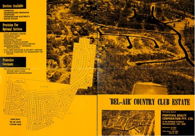
Flyer, Land Sale Brochure, Bel-Air Country Club Estate, North Ringwood - circa 1978
Double sided A2 size yellow and black gloss print advertisement for residential subdivision, with progressive allotment price list notices. Subdivision includes Glenvale Road, Kubis Drive, June Square, Jenkins Close, Werac Drive, Manuela Terrace, Rudolf Court, Lyn Court, Burlock Avenue, Debbie Place, Pamela Place, Iluka Place, Chifley Parade, Menzies Crescent.Vendor and Managing Agents - McKuke Pty Ltd (Frank Kubis) and Perpetual Realty Corporation Pty. Ltd., 97-99 Spring Street, Melbourne, Vic. 3000. Telephone 63 4881, 63 3721, After hours 299 2085, (059) 84 1381. -
 Lakes Entrance Historical Society
Photograph - Whiter's Camp Park, Bulmer H D, 1935
Black and white aerial view of Whiters Camp Park, looking north from Roadknight Street, showing layout of park including tennis courts, bowling green, picnic area, cottages, rotunda, and the family residence. Lakes Entrance Victoria tourism, camping -
 Bendigo Historical Society Inc.
Document - MISS G ALICE JONES COLLECTION: ACCOUNT
Bendigo Amalgamated Gold Fields Ltd. To Miss G. Alice Jones. Re You V Geo Lakey - County court Summons £59.18.3. Scale C, Sale to Ennor. To Osgood, Land Tax, You V Brauman C. C. S. No. 27 (Special) Scale D £137.1.7, You V Brauman C.C.S. No. 38 (Ordinary), You V Brauman C.C.S. 1924 No. 43 (Special) £137.1.7., Clarence Freeholds-Sale to Bowden, Sea Co. Machinery & Freehold land, Land transferred from New Vic. Catherine Co., re Koch's Pioneer G.M. Co. N.L. transfer of G.M. Lease No 9791 Bendigo, re North Ulster G.M. Co. N.L. transfer of G.M Lease No. 9789 Bendigo. Details of costs and dates varying from June 28, 1923, to March 30, 1925.Also dated 3/6/25 and Pd 30/7/25.the miss g. alice jones collection - account, bendigo amalgamated goldfields ltd, geo lakey, mr stanfield, mr jn smalley, mr thomson, mr crow, mr ennor, osgood, mylon, mrs murdock, constable thomson, brauman, mr miller, melbourne sun, clarence freeholds, j h curnow & son, gazette, sea co, mr legge, mr skews, h m legge & co, new vic catherine co, koch's pioneer g m co nl, north ulster g m co nl, g m lease no 9789 bendigo -
 Ballarat Tramway Museum
Album - Postcards & Photographs - Vic Solomons and others - Australian Tramways, Vic Solomons, 2023
Contains 184 images of postcards and photographs collected primarily by Vic Solomons of Sydney, with others from the collection of Wal Jack and Warren Doubleday. Covers almost all of Australia's tramway systems. 1 Post Card Hay St Perth Looking East No 3 Unknown Perth 2 Post Card Cars 30 & 90 both on Route 19 pass in Barrack St looking South Perth WA 1935.02.18 Perth 3 Post Card Hay St Looking East Perth WA Unknown Perth 4 Post Card William St Perth WA Unknown Perth 5 Post Card Perth from Shaftsbury Hotel Unknown Perth 6 Post Card Hay St Perth WA Looking East Unknown Perth 7 Post Card Barrack St Perth Unknown Perth 8 Post Card Murray Views No 3 High St Showing Town Hall Fremantle WA Unknown Fremantle 9 Post Card High St Fremantle WA Unknown Fremantle 10 Post Card View of Bolder City Golden Mile in the Background (Section No 1) 1908.08.20 Kalgoolie 11 Post Card Hannan St Kalgoolie 1900.08.19 Kalgoolie 12 Post Card Hannan St Kalgoolie WA (No 2) Unknown Kalgoolie 13 Post Card Intersection Hannan & Maritana Sts Kalgoolie WA Unknown Kalgoolie 14 Post Card Hannan St Kalgoolie Unknown Kalgoolie 15 Post Card Lane Street Bolder City Unknown Kalgoolie 16 Post Card Hobart Double Deck Tram Unknown Hobart 17 Post Card Macquarie St Hobart Unknown Hobart 18 Photo Liverpool Street Hobart Unknown Hobart 19 Photo Hobart 21 Unknown Hobart 20 Photo Hobart 14 in Elizabeth St Hobart Unknown Hobart 21 Post Card Macquarie St Hobart Unknown Hobart 22 Post Card Macquarie St Hobart Tas Unknown Hobart 23 Photo Double Decker Tram 3 at G.P.O. Hobart Tas No 31 Unknown Hobart 24 Post Card Double Decker Tram 19 Hobart Tas A B Series No 24 Unknown Hobart 25 Photo Hobart Municipal Tramways Tas No 95 Unknown Hobart 26 Post Card Elizabeth St Hobart Unknown Hobart 27 Post Card Elizabeth St Hobart Unknown Hobart 28 Post Card Elizabeth St Hobart Unknown Hobart 29 Post Card Elizabeth St Hobart Tas Unknown Hobart 30 Post Card HMT 21 with crew at Beach Road Terminus Unknown Hobart 31 Post Card HMT 9 & another with crew at Beach Road Terminus. Front cover photo of Destination GPO 1921.01.00 Hobart 32 Post Card Cascade Road and Mount Wellington Hobart Unknown Hobart 33 Post Card Elizabeth St Hobart Unknown Hobart 34 Post Card Elizabeth St Hobart Unknown Hobart 35 Post Card Elizabeth St Hobart 1915.04.07 Hobart 36 Post Card Macquarie St Hobart Tas Unknown Hobart 37 Post Card Macquarie St showing Post Office Hobart 1908.03.12 Hobart 38 Post Card Hobart Municipal Tramways 21 Unknown Hobart 39 Post Card Elizabeth St Hobart Tas Unknown Hobart 40 Post Card Liverpool Street Hobart Unknown Hobart 41 Post Card Electric Tram Launceston Tas 446 W J Little Photo 1919.02.08 Launbceston 42 Post Card Launceston Tram no 3 1911.08.30 Launbceston 43 Post Card Launceston Tram no 3 passes tram No 1 Unknown Launbceston 44 Post Card Tram 6 at Trevallyn a popular suburb Launceston Tasmania Unknown Launbceston 45 Post Card Tram 7 at Trevallyn Road Terminus Launceston Tasmania Unknown Launbceston 46 Post Card Tram 4 in Brisbane St Launceston Unknown Launbceston 47 Post Card Tram 9 in Brisbane St Launceston Tasmania Unknown Launbceston 48 Post Card Camerom Street Launceston Tasmania Unknown Launbceston 49 Post Card Murray Views No 15 Jetty Road Glenelg Terminus 1962-02-08 Adelaide 50 Post Card Bay Tram at Jetty Road Terminus Glenelg SA Unknown Adelaide 51 Post Card Tram 3 in King William Street Adelaide S Aust Unknown Adelaide 52 Post Card Valentine Series No 3065 The Old Horse Tram Victor Harbour Unknown Victor Harbour 53 Post Card Bourke Street Melbourne with Cable Car Looking East 1904.04.25 Melbourne 54 Post Card Opening of New Electric Tramway Elsternwick 1913-11-13 Melbourne 55 Post Card Cable trams in Clarendon St Sth Melb Unknown Melbourne 56 Post Card Pall Mall from Charing Cross Bendigo Unknown Bendigo 57 Post Card Tram 4 & 7 pass at The Fountain and Mitchell Street Bendigo Vic Rose Series P 3198 Unknown Bendigo 58 Post Card M&MTB 133 at Charing Cross bound for Eaglehawk Bendigo Vic Murray Views No 45 Unknown Bendigo 59 Post Card Pall Mall Bendigo Vic Unknown Bendigo 60 Post Card Charing Cross & Mitchell St Bendigo Trams passing 1919.00.00 Bendigo 61 Post Card Pall Mall Looking East Unknown Bendigo 62 Post Card Electric Trams and City Hotel Bendigo Vic Unknown Bendigo 63 Post Card Moorabool Street Geelong V 23 Unknown Geelong 64 Post Card Murray Views No 3 Moorabool Street Geelong Vic Unknown Geelong 65 Post Card The Rose Series P 2487 Ryrie Street Geelong Vic Unknown Geelong 66 Post Card Southern Cross Series 2696 Ryrie Stret Geelong Vic Unknown Geelong 67 Post Card The Rose Series P 1490 Ryrie Street Geelong Vic 1920-03-04 Geelong 68 Post Card Valentine Series No 1568 Lower Sturt Street Ballarat Unknown Ballarat 69 Post Card Rose Series P 1710 Sturt Street Ballarat Victoria Unknown Ballarat 70 Post Card Sturt Street Ballarat Victoria Unknown Ballarat 71 Post Card Horse Tram In Sturt Street Ballarat 1905.11.10 Ballarat 72 Post Card Sturt Street Ballarat Looking North-West Unknown Ballarat 73 Post Card Shoppes Square Sturt Street Ballarat Looking North Unknown Ballarat 74 Post Card Junction Sturt and Lydiard Streets Ballarat 1909-09-01 Ballarat 75 Post Card The Electric Supply Co Souvenir Tram Ticket No 3085of the opening of Electric System August 18 1905 1905.08.18 Ballarat 76 Post Card Sturt Street Ballarat Victoria 1907.11.25 Ballarat 77 Post Card Off to the Gardens Electric Tram Ballarat Unknown Ballarat 78 Post Card Sturt Street Ballarat 1907.04.16 Ballarat 79 Post Card Sturt Street Ballarat Looking East Electric tram with Double Deck Trailer 1911.04.17 Ballarat 80 Post Card Sturt Street Ballarat Looking East Unknown Ballarat 81 Post Card Sturt Street Ballarat Looking West 1911.03.01 Ballarat 82 Post Card Town Hall and Sturt Street Ballarat Unknown Ballarat 83 Post Card Lydiard Street Ballarat 1906.11.23 Ballarat 84 Post Card Looking North along Adelaide Street from George Street Brisbane Sidues Series No 764 Unknown Brisbane 85 Post Card Looking South along Queen Street from the Creek Street Intersection Brisbane Qld Sirues Series No 1379 Unknown Brisbane 86 Post Card George Street from near Supreme Court Brisbane Unknown Brisbane 87 Post Card Queen and Eagle Streets Brisbane 1907.07.04 Brisbane 88 Post Card Queen Street showing His Majesty’s Theatre Brisbane Unknown Brisbane 89 Post Card Queen Street Treasury Building 1908.01.20 Brisbane 90 Post Card G P O and Queen Street Brisbane Unknown Brisbane 91 Post Card Queen Street Brisbane Looking from Wharf Street Unknown Brisbane 92 Post Card Customs House Brisbane 1905.02.16 Brisbane 93 Post Card Queen St Brisbane 1905.09.16 Brisbane 94 Post Card Queen St Brisbane 1907.11.19 Brisbane 95 Post Card Treasury Buildings Brisbane Unknown Brisbane 96 Post Card Queen and Eagle Streets Brisbane Unknown Brisbane 97 Post Card The Valley Corner Brisbane Unknown Brisbane 98 Post Card Brisbane Queen Street opposite General Post Office Unknown Brisbane 99 Post Card North Quay and Milton Beach Brisbane Q Unknown Brisbane 100 Post Card Victoria Bridge Brisbane South Side 1907.08.14 Brisbane 101 Post Card Victoria Bridge Brisbane Unknown Brisbane 102 Post Card Breakfast Creek Bridge Brisbane Q Unknown Brisbane 103 Post Card Melbourne Street Station South Brisbane Queensland Unknown Brisbane 104 Post Card General Post Office Queen Street Brisbane 1955.09.23 Brisbane 105 Post Card Customs House Brisbane 1904.11.04 Brisbane 106 Post Card Queen St Brisbane 1919.11.00 Brisbane 107 Post Card Queen St Brisbane Sidues Series No 627 Unknown Brisbane 108 Post Card Creek Street Brisbane Queensland Unknown Brisbane 109 Post Card Customs House and Garden Reach Brisbane Queensland 1910.00.08 Brisbane 110 Post Card Queen and Creek Streets Brisbane 1909.06.07 Brisbane 111 Post Card Queensland National Bank andd Queen Street Brisbane Queensland Unknown Brisbane 112 Post Card Queen Street and Treasury Buildings Brisbane 0000.09.07 Brisbane 113 Post Card Queen Street showing “Courier” Buildings Brisbane Unknown Brisbane 114 Post Card Intersection George & Roma Streets Brisbane Q 1916.05.11 Brisbane 115 Post Card Adelaide Street Brisbane Q Unknown Brisbane 116 Post Card G P O Queen Street Brisbane Q Unknown Brisbane 117 Post Card Treasury Building Brisbane 1906.03-20 Brisbane 118 Post Card Queen and Eagle Streets Brisbane 1907.02.01 Brisbane 119 Post Card Queen St Brisbane Unknown Brisbane 120 Post Card Queen St Brisbane Q Unknown Brisbane 121 Post Card Victoria Bridge Brisbane 1906.07.30 Brisbane 122 Post Card An Unusual View showing Head of Queen Street Victoria Bridge & South SideSuburbs Brisbane Q Unknown Brisbane 123 Post Card Petries Bight Brisbane Q Unknown Brisbane 124 Post Card South End Victoria Bridge Brisbane Q Unknown Brisbane 125 Post Card Customs House Brisbane Unknown Brisbane 126 Post Card Photo of toastrack car circa 1910 Unknown Brisbane 127 Post Card Treasury Buildings Brisbane Unknown Brisbane 128 Post Card East Street Rockhampton with Steam Tram & trailer Unknown Rockhampton 129 Post Card Post Office Rockhampton with steam tram Unknown Rockhampton 130 Post Card East Street Rockhampton with Steam Trams Rose Series P 7154 Unknown Rockhampton 131 Post Card William Street Rockhampton Rose Series P 7156 Unknown Rockhampton 132 Post Card Central East Street Rockhampton Q with Steam Trams Unknown Rockhampton 133 Photo Sturt St Ballarat Unknown Ballarat 134 Photo Bridge Street Ballarat Unknown Ballarat 135 Post Card George St Sydney Unknown Sydney 136 Post Card Elizabeth St Sydney Unknown Sydney 137 Post Card Railway Square Unknown Sydney 138 Post Card Sydney Harbor Bridge - pending receipt 139 Post Card Kings Cross - Mowbray Series with description on rear from C Roy G Field Unknown Sydney 140 Post Card Kings Cross - Mowbray Series with description on rear from C Roy G Field Unknown Sydney 141 Post Card Central Railway Station Sydney - Rose Series P6033 1954-01-26 Sydney 142 Post card William Street Darlinghurst looking towards City - Rose Series P6602 unknown Sydney 143 Post Card Circular Quay Sydney - Rose Series P6680 Unknown Sydney 144 Post Card View at Manly NSW - Rose Series B1003 Unknown Sydney 145 Post Card Hunter St Newcastle NSW - Rose Series P7843 Unknown Newcastle 146 Post Card Bank Corner Newcastle NSW - Mowbray Series No. 155 Unknown Newcastle 147 Post Card Hunter St Newcastle NSW Unknown Newcastle 148 Post Card Criterion Hotel Hunter St Newcastle NSW Unknown Newcastle 149 Photo Horse tram at Newtown Station 1894 to 1898 - PTC photo c1894 Newtown 150 Photo Steam tram motor No 3 at Railway Square 1879 1879 Sydney 151 Photo Railway steam tram c1900 with a horse drawn double deck bus c1900 Sydney 152 Photo Steam motor 5A and doubled deck bus Unknown Sydney 153 Photo Steam motor 53A with detail notes on rear 1922 Sydney 154 Photo Cable tram set at Milsons Point ferry terminal c1900 Sydney 155 Photo Early Sydney electric car - Ocean St - Rose Bay Unknown Sydney 156 Photo George St looking souoth c1905 c1905 Sydney 157 Photo Tram 165 at Circular Quay Unknown Sydney 158 Photo Tramcar ferry or transporter at The Spit Unknown Sydney 159 Photo tram 882 George St at Marti Place, 1937 1937 Sydney 160 Photo Tram 826 Railway Sq area Unknown Sydney 161 Photo Railway Sq in background, Broadway with double decker bus and toastrack car late 1930s Sydney 162 Photo Coupled St Pitt St? - photo Ben Parle Feb. 1950 Sydney 163 Photo Electric tram No. 2 - North Sydney with side trolley pole running Unknown Sydney 164 Photo George St - Horden's Corner Unknown Sydney 165 Photo George St at Martin Place c1920 Sydney 166 Photo Castlereagh St Sydney c1928 c1928 Sydney 167 Photo Railway Sqare c1920 c1920 Sydney 168 Photo Darling St Countereweight Unknown Sydney 169 Photo Trolley bus depot Unknown Sydney 170 Photo Trolley bus No. 14 Unknown Sydney 171 Photo Newcastle Railway Station with steam tram - Wharf Road?? Unknown Newcastle 172 Photo High St West Maitland - steam tram Unknown Maitland 173 Photo High St West Maitland - steam tram Unknown Maitland 174 Post Card Argent St near tram terminal Broken Hill NSW c1900 Broken Hill 175 postcard Argent St looking south Broken Hill - with Ken Magor's notes on rear Unknown Broken Hill 176 Photo Toronto - steam tram 61A Unknown Toronto 177 Photo 124A trial run 1911? Sutherland - Cronulla line 1911 Sutherland 178 Photo 103A at a tram stop Unknown Sydney 179 Photo Cable tram set at Crows Nest terminus grip car 12, trailer 22 Unknown Sydney 180 Photo Cable tram Queens Square Sydney 1903 Sydney 181 Photo cars 2078 and 2077 Chatswood late 1950s Sydney 182 Photo car 1877 Balmain area late 1950s Sydney 183 Photo Trolley bus - Rockdale destination Late 1950s Sydney 184 Photo Broken Hill steam tram - motor 18A North Tram Unknown Broken Hill 185 Photo Millars Point Sydney NSW - ferry/tram interchange, unknown Sydney All items imaged including the rear or back where there was writing of information. All files stored on the Museum's Photo Collections directory. Demonstrates through the medium of many images, Australian tramway systems and Ballarat's place in them.Album - heavy card covers, plastic lined with postcard or 6x4 photo sleeves.australia, tramways, postcards, photographs, steam trams, horse trams, cable trams, trolley buses -
 Wodonga & District Historical Society Inc
Photograph - First Presbyterian Church, Wodonga
Members of the Presbyterian faith were among the first settlers in the North-east of Victoria, and in the year 1842 the Presbytery of Melbourne requested the Rev. Peter Gunn, Minister of the Gaelic Church, Melbourne, to visit Presbyterians along the Murray River. This was the first of a series of annual visits, and was of a missionary nature. In May 1851, the Rev. David Hunter Ballantyne was appointed to the Wodonga district based out of Albury. In 1860 the Presbytery of Beechworth was formed, and from it two large presbyteries have grown - Wagga Wagga and Beechworth. In the early days the services at Wodonga were held in the old court house, which still stands. Wodonga Presbyterian Church continued as part of the Parish of Albury until the end of 1887, when it was placed under the administration of the Session of the Beechworth Church, with a home missionary in charge. Mr William Cooper was placed in charge for the first months, then Mr William Smith, a city missionary who had recently arrived from Scotland, was appointed. Mr Smith conducted a cordage factory at Stonleigh. He remained as missionary in charge for the next 10 years, and in that time the church steadily progressed. Plans were made for the erection of the building which now stands in High Street, Wodonga. Mr John Whan was a Founding Member of the Church and was appointed Sunday School Superintendent, an office which he held for 46 years, rendering extensive and valued service to the church and congregation. With a growing congregation and realising the challenges presented to the Church by changing conditions, land for a new church was sought. In September 1950 property was purchased in Nilmar Avenue in Wodonga and the new Presbyterian Church St Stephens became their new home. With the amalgamation of the Presbyterian and Methodist Churches, the new Church became the Uniting Church. The original Presbyterian Church was later sold to the Free Serbian Orthodox Church.These photographs are significant because they provide evidence of the changing nature of religious worship and groups in Wodonga.A collection of black and white photographic images depicting the first Presbyterian Church at Wodonga. The Church was later taken over by the Free Serbian Orthodox Church.presbyterian church, free serbian orthodox church, wodonga churches -
 Eltham District Historical Society Inc
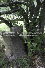
Photograph - Digital Photograph, Alan King, Heritage apple tree, 24 January 2008
This old apple tree situated beside the Plenty River Trail at Greensborough has been associated with Melbourne Founder John Batman. The concrete block is inscribed with the date 1841, when the tree was thought to have been planted. Known as Batman's Tree, this apple tree is on the bank of the Plenty River near Leischa Court, Greensborough. It is said that Melbourne Founder John Batman may have planted the tree and later signed his treaty here with the Aboriginal people. It still bears fruit and its recorded on the National Trust's Register of Significant Trees, as the oldest apple tree in Victoria. Published: Nillumbik Now and Then / Marguerite Marshall 2008; photographs Alan King with Marguerite Marshall.; p7This collection of almost 130 photos about places and people within the Shire of Nillumbik, an urban and rural municipality in Melbourne's north, contributes to an understanding of the history of the Shire. Published in 2008 immediately prior to the Black Saturday bushfires of February 7, 2009, it documents sites that were impacted, and in some cases destroyed by the fires. It includes photographs taken especially for the publication, creating a unique time capsule representing the Shire in the early 21st century. It remains the most recent comprehenesive publication devoted to the Shire's history connecting local residents to the past. nillumbik now and then (marshall-king) collection, greensborough, john batman tree, plenty river trail -
 Eltham District Historical Society Inc
Photograph - Digital Photograph, Alan King, Maroondah Aqueduct Siphon Bridge over the Plenty River, 26 January 2008
Opened in 1891, the bridge formed part of the Maroondah Aqueduct carrying water from Watts River near Healesville to the reservoir at Preston where it joined Melbourne's metropolitan water system. Covered under Heritage Overlay, Nillumbik Planning Scheme. Published: Nillumbik Now and Then / Marguerite Marshall 2008; photographs Alan King with Marguerite Marshall.; p99 Built to supply thirsty Melbourne in the late 19th century, the siphon bridge spanning the Plenty River off Leischa Court, Greensborough, was part of an engineering masterpiece. Opened in 1891, the bridge formed part of the Maroondah Aqueduct carrying water from the Watts River near Healesville to the reservoir at Preston where it joined the metropolitan distribution system. A major link in Melbourne’s water supply, it also had a huge impact on communities, which mushroomed along its route. Named after the Aboriginal word for the area around the Maroondah Reservoir, the Maroondah Aqueduct was fully operational until the 1970s. Since the 1980s the land along parts of the aqueduct have been used for walking and bicycle riding, shaded in places by Monterey Pine trees planted to stabilise the surrounding ground. From 1857 the Yan Yean Reservoir supplied Melbourne’s water but the growing city needed additional catchments.1 In 1886 work began on a weir on the Watts River to enable the aqueduct to carry most of the river water 41 miles (66km) to Melbourne. The aqueduct, built by the Board of Works, is the oldest remaining aqueduct near Melbourne and was probably the first built with concrete.2 Although the aqueduct is now only used between the Maroondah and Sugarloaf Reservoirs, it can still be traced across the Shire. It extends from the Maroondah Reservoir through Christmas Hills, Kangaroo Ground, Research, Eltham, St Helena and then previously wound west through Greensborough to Reservoir.3 Built by horse and manpower the aqueduct gravity fed 25 million gallons (113.6ML) of water a day to Melbourne along a gradient of one foot to the mile. It included 25 miles (41km) of open concrete and brick channel, six miles (10km) of tunnels, and nine miles (15km) of 14 inverted siphons of riveted wrought-iron across creeks. Bricks for the aqueduct were made from clay found near the sites and remains of several kilns can still be found between Kangaroo Ground and Christmas Hills. Building the aqueduct transformed local communities. An abattoir was established at Christmas Hills. Grog shanties and labourers’ camps sprang up and local courts dealt with cases of ‘petty pilfering and boisterous behaviour’.4 The Kangaroo Ground school population jumped to 91, crammed into a room with one teacher. Miners who built the tunnels camped just north of Churinga in Greensborough – then called Tunnel Hill Camp – and adjacent to the Evelyn Arms Hotel. The miners’ high spirits were sometimes quenched in horse troughs or by a ‘welt under the ear and kick on the behind’ as the local constable calmed them down rather than lock them up.5 But the growing city of Melbourne needed more water, so the O’Shannassy catchment, east of Warburton, was added to the system in 1914. In 1920 work began on the present concrete Maroondah Dam one mile (1.6km) from the weir on the Watts River. The aqueduct capacity was thus doubled to 50 million gallons (227ML) a day.6 Intense land development threatened to pollute the open water supply, so channel sections were replaced with large pipes. In the late 1960s a large water main was built from the tunnel outlet at Research and extended through St Helena and Greensborough, so this section of the aqueduct was taken out of use. Long sections of the unused open channels in Greensborough and Bundoora were destroyed, but the old channel in Research and Eltham North remained largely intact. In the 1970s, the Sugarloaf Reservoir was constructed, inundating 445 hectares of land in Christmas Hills. Sugarloaf was officially opened in 1980 and serves as a water storage and treatment plant supplying Melbourne. In the early 1980s pipes replaced the section from Sugarloaf Reservoir to the tunnel entrance at Kangaroo Ground. The Research-Kangaroo Ground tunnel operates as part of the pipeline system.This collection of almost 130 photos about places and people within the Shire of Nillumbik, an urban and rural municipality in Melbourne's north, contributes to an understanding of the history of the Shire. Published in 2008 immediately prior to the Black Saturday bushfires of February 7, 2009, it documents sites that were impacted, and in some cases destroyed by the fires. It includes photographs taken especially for the publication, creating a unique time capsule representing the Shire in the early 21st century. It remains the most recent comprehenesive publication devoted to the Shire's history connecting local residents to the past. nillumbik now and then (marshall-king) collection, maroondah aqueduct, pipe bridge, siphon bridge -
 Eltham District Historical Society Inc
Photograph - Digital Photograph, Marguerite Marshall, Jelbart home, 93 Arthur Street, Eltham, 11 November 2006
Situated at the top of the hill in Arthur Street, the former Jelbart residence and barn were part of a major change that transformed Eltham's character in the late 1960s. Built from the mid 1940s through mid 1950s when Eltham was a rural community, the Jelbrat residence and barn are all that remain of a family property of some 250 acres (100 ha). With growing population pressures, in the late 1960s, owners Ron and Yvonne Jelbart decided to subdivide their property creating the Woodridge Estate in the early 1970s, a major factor towards the transformation of Eltham to the suburb it is today. The Jelbarts had moved to Eltham in the early 1940s when they purchased a poultry farm in New Street, now Lavendar Park Road. (The local Black Friday bushire of January 13, 1939 had started at C.A. (Clarrie) Hurst’s Eltham Poultry Farm and Hatchery in New Street.) Jelbart was primarily a businessman importing office machinery but desired farm beef and dairy cattle so the couple purchased the virgin bushland at what was then at the end of a dirt road, Arthur Street. With post war shortages of most building materials, they followed the example of the Eltham Artists' Colony (later called Montsalvat) and built thier home from mud-bricks and recyclked materials. The barn was first to be completed in 1945 which they made their home whilst building the main residence. It took eight years to complete the two buildings. Both the main residence and the barn are now separate homes, and along with the remaining property being sub-divided further in 1998 are now part of the Kinloch Gardens Estate at 93 Arthur Street. Covered under Heritage Overlay, Nillumbik Planning Scheme. Published: Nillumbik Now and Then / Marguerite Marshall 2008; photographs Alan King with Marguerite Marshall.; p139 Standing on a hilltop at Arthur Street, Eltham, the Jelbart residence and former barn were part of a major change that transformed Eltham’s character in the late 1960s. Built from the late 1940s to the mid 1950s when Eltham was a rural community, they are all that remain of what was once a family property of around 250 acres (100 ha). As population pressure increased in the late 1960s, owners Ron and Yvonne Jelbart, decided to subdivide their property. The break-up of this property into the Woodridge Estate in the early 1970s, was a major factor towards transforming Eltham into the suburb it is today.1 Although standing only a few minutes from Eltham’s busy hub and hundreds of houses in Woodridge, scarcely any urban sound disturbs the peace. Views from the two buildings are almost exclusively of trees and extend to Mt. Dandenong to the south-east, the Great Divide to the north, and Melbourne city to the south-west. The Jelbarts had lived in Eltham since the early 1940s when they bought a poultry farm in New Street, now Lavender Park Road. Although Jelbart was primarily a businessman importing office machinery, he was keen to farm dairy and beef cattle, so the couple bought rough bushland at what was then the end of Arthur Street. But a shortage of building materials following World War Two hampered their plans to build their new home, so they followed the example of the Eltham Artists’ Colony (later called Montsalvat) and used mud-bricks and recycled materials.2 With great determination the family and friends constructed their house. Massive timber frames and huge quantities of mud-bricks were made on site. The barn was built first in 1945, and two years later, while camping inside, the Jelbarts started building their house. It took eight years to construct the two buildings, even with the help of professional tradesmen. The buildings, with timber frames infilled with mud-brick and plastered, are reminiscent of the English Tudor style. The Jelbarts are of Cornish stock. Much of the timber framework came from demolished bridges or warehouses, and recycled slate was used for roofs and floors. Quality second-hand materials were readily available in the late 1940s and 1950s when there was much demolition in Melbourne and little respect for heritage. A former 19th century Toorak mansion Woorigoleen provided the magnificent stone fireplace, the timber panelling and the parquetry floor in the living room. The large stone gateposts at the entry of the property came from Melbourne University. Almost no mechanical equipment was used to build the 55 square house and the 25 square barn. Massive timber frames were erected using block and tackle pulleys and timbers were shaped, sawn and drilled by hand. Son and architect Ian, with his family, have lived in and extensively renovated both buildings since the early 1970s. Ian transformed the steep ridge of the property into a plateau, where the main house Kinloch stands, surrounded by terraces and lawns. The grounds retain many native plants, including massive yellow boxes – some nudging 80 years. Ian attached 70 metres of pergolas draped with wisteria, roses and grape vines, to three sides of the house. The beautiful garden is featured in the book Through the Rose Arbour by Rosemary Houseman. The two-storey barn – now a house – retains traces of its original use. The cow-shed with milking and feed-rooms, and the machinery-shed remain. The house, separated on the ground floor by a breeze-way, soars two storeys and includes a mezzanine. These are connected by spiral staircases, to timber-beamed and plaster-lined high-pitched ceilings. The house also descends to a wine cellar. Curiously the roof is of corrugated iron on the south and slate on the north, to save costs. Small-paned windows and three French doors open onto the front lawn, which extends to Jelbart Court.This collection of almost 130 photos about places and people within the Shire of Nillumbik, an urban and rural municipality in Melbourne's north, contributes to an understanding of the history of the Shire. Published in 2008 immediately prior to the Black Saturday bushfires of February 7, 2009, it documents sites that were impacted, and in some cases destroyed by the fires. It includes photographs taken especially for the publication, creating a unique time capsule representing the Shire in the early 21st century. It remains the most recent comprehenesive publication devoted to the Shire's history connecting local residents to the past. nillumbik now and then (marshall-king) collection, eltham, arthur street, jelbart barn, jelbart home, kinloch gardens -
 Eltham District Historical Society Inc
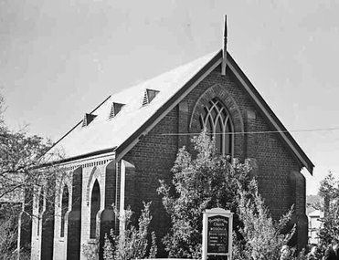
Photograph - Digital Photograph, Alan King, Eltham Court House, 730 Main Road, Eltham, 28 December 2007
The Eltham Court House is Eltham's oldest public building. It was classified by the National Trust in 1977. In 1857 five Eltham residents petitioned the licensing magistrates of the Heidelberg district asking for better police protection, including from itinerant gold prospectors who turned to crime when their quest was unsuccessful. In response the Eltham Courthouse was constructed in 1860. Over the years it has also been used for other activities, including for electoral polling purposes, inquests, early meetings of the Eltham Roads Board and even as an overflow classroom. This type of localised solution is characteristic of the self-reliance preserved in Eltham today. The court house is an important symbol of the spirit which makes Eltham distinctive as a community. The Eltham Courthouse is historically significant because its construction was intended to emphasise the centralised control over law and order in the Colony of Victoria in the wake of the 1852 Snodgrass committee report on the Victorian police force and the resulting Police Regulation Act (1853). The nature of the Court House planning and use of architectural devices make the building's function easily interpreted. The arrangement of rooms, with public entry and clerical rooms to the rear, and the use of raised floor levels throughout these spaces to signify relative rank is easily perceived. The distinction in entries, public, magistrate and person-in-custody, and the existing court furniture enhances appreciation of this building. The Eltham Court House is one of only two intact examples in the state of this simple design with projecting entry. The building is of architectural significance because it retains intact early features. These include use of handmade bricks, simple decoration, roof trusses, timber ceiling boards, original windows, doors and associated hardware and a collection of court furniture. Additions to the court house have been done in a manner which did not interfere with the fabric of the original building. Typical cases heard before the Court of Petty Sessions included financial debt, straying livestock, theft, assault, drunkenness, public disorder, truancy, motor vehicle offences, unregistered animals and failing to have children attend school, or be vaccinated. The courthouse operated for over 120 years before it closed in 1985. In April 2021, Nillumbik Shire Council authorised restoration of the building and furnishings. The extensive works required for the total restoration of this highly valued heritage building was undertaken by Ducon Building Solutions and other specialist contractors. Covered under Heritage Overlay, Nillumbik Planning Scheme. Victorian Heritage National Trust of Australia (Victoria) State significance Published: Nillumbik Now and Then / Marguerite Marshall 2008; photographs Alan King with Marguerite Marshall.; p65 A demand for better police protection resulted in the building of the Eltham Courthouse and the police residence beside it. In 1857 five Eltham residents petitioned the Heidelberg district licensing magistrates. They pointed out that Eltham had two hotels, a population of about 1000, and many strangers employed on the public roads. Yet the nearest police were at Heidelberg eight miles (12.8km) away, or at the Caledonia Diggings 21 miles (33.7km) away.1 Subsequently the courthouse and then the police residence, near the corner of Main Road and Brougham Street, were built in 1859/60. The courthouse is Eltham’s oldest public building and the National Trust classified it in 1977. It ceased operation in 1984 and has since been used by local groups. There are only six other known examples of similar small brick country courthouses in Victoria . For £536, a Mr Duncan built the courthouse – a neat, narrow, oblong building with handmade orange bricks. Its gabled roof and porch are covered with brown slate tiles and it has 12-paned windows. Inside, the roof is peaked and the courthouse is still ventilated by oblong slits near the ceiling. Most of the fine carved timber and upholstered furniture is original. The original prisoners’ door, now permanently closed, led from the police station to the dock. Builders, Langridge Wright and Witney built a timber police station (since demolished) and a brick residence to its north,2 for £1150/7/-. Built around the same time were the lock-up behind the residence, also later demolished, and the two-storey orange brick stables. The former police residence also has a brown slate roof and handmade bricks. The front veranda roof is made of corrugated iron, as is the roof of the back weatherboard extension. The application for police protection was approved within a few months and police operated from a cottage rented at ten shillings a week and owned by William Jarrold. This was probably the one at the corner of Main Road and Dalton Street called Jarrold or White Cloud Cottage. In 1858 a second constable was appointed to Eltham following a fight at the hotel. The timber police office a replica of which was built in the early 1990s is at the building’s side. The lock-up was demolished following the relocation of the police to a new station in about 1952. The residence has been used as the Eltham District Historical Society centre since 1997. Records show court cases were held at Eltham before the courthouse was built, but the location is unknown. Some court cases were not very different from those today. In 1891 a man was charged with being drunk while in charge of a horse and was fined ten shillings. The courthouse was used for other purposes during its long history. It was probably used as a polling place as indicated by old photographs of election-day crowds outside. The Eltham Road Board met there from the early 1860s until 1868 when the Board transferred to Kangaroo Ground. During the same period the Road Board Secretary used the courthouse as an office until 1867 when it was transferred to his home at Wingrove Cottage. The courthouse was also used as an overflow classroom for the Dalton Street school in 1875. The two buildings can further link us with Eltham’s early days through Police Department correspondence. The first constable-in-charge was George Reid. In 1860 a letter to The Argus newspaper signed ‘A Sufferer’ declared the Eltham police were not active enough in their duties. The writer suggested that the ‘very snug’ police quarters were too comfortable, and he detailed various incidents including one of an alleged break-in to the Road Board Secretary’s home. But the Board Secretary, C S Wingrove, wrote to the Police Department refuting The Argus letter saying he had received full co-operation from Sen. Constable Peter Lawler.This collection of almost 130 photos about places and people within the Shire of Nillumbik, an urban and rural municipality in Melbourne's north, contributes to an understanding of the history of the Shire. Published in 2008 immediately prior to the Black Saturday bushfires of February 7, 2009, it documents sites that were impacted, and in some cases destroyed by the fires. It includes photographs taken especially for the publication, creating a unique time capsule representing the Shire in the early 21st century. It remains the most recent comprehenesive publication devoted to the Shire's history connecting local residents to the past. nillumbik now and then (marshall-king) collection, eltham, eltham court house, main road -
 Ringwood and District Historical Society
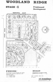
Flyer - Land Sale, Preplanned Development - Woodland Ridge Estate Stages 1, 2 and 3, Ringwood North, Vic. - circa 1972
Subdivison maps of Woodland Ridge Estate. Stage 1 includes Berringa Road, Oban Road, Athelstane Drive, Braimton Close, Karima Court, Tania Place, Runyan Court. Stage 2 includes Athelstane Drive, Cormiston Road, Linda Place, Casula Place, Oban Road. State 3 includes Williams Road, Athelstane Drive, Tania Place and Cormiston Road. Developer - A.V. Jennings Industries (Aust) Ltd., 690 Springvale Road, Mulgrave, 3170. Phone 560 8411. Supplementary page with early 2000s sale prices for eight addresses - 16 Athelstane Drive Ringwood 3134 $210,000 4/4/2000 19 Athelstane Drive Ringwood 3134 $235,000 14/1/2000 27 Cormiston Road Ringwood 3134 $246,000 28/10/2000 1 Runyan Court Ringwood 3134 $183,000 2/5/2001 4 Runyan Court Ringwood 3134 $179,000 14/8/2000 11 Runyan Court Ringwood 3134 $193,000 28/4/2000 7 Runyan Court Ringwood 3134 $187,500 14/1/2000 4 Casula Place Ringwood 3134 $216,000 13/2/2001 Accompanying handwritten notation by Richard Carter R.E.S.I. - "Purchaser of 'Pre-planned Development' lots also agreed to purchase the house planned for the lot. Bramton Court "Witheld" for display homes. Stage 3 one acre sites drained north therefore not readily sewered." -
Glen Eira Historical Society
Article - Glen Eira Parks and Gardens
This file contains four items. 1/ An article in the Glen Eira News reporting on a new park with indigenous planting and an interpretive walk being developed to link Duncan McKinnon Reserve and Packer Park in Murrumbeena, dated September 2000. 2/ An article from the Glen Eira Leader on the converting of sports grounds from cool season to warm season grasses, as well as the installation of subsurface drip irrigation at Princes Park, Caulfield South, dated March 2012. 3/ An article from the Caulfield/Port Phillip leader reporting Caulfield RSL military historian Carl Johnson’s appeal to have a “lone pine” in Caulfield Park designated as a war memorial, dated 11/9/2012 4/ An article from the Glen Eira/Port Phillip Leader reporting on the Friends of Caulfield Park organising the first band stand concert in over twenty years with the City of Glen Eira Band, dated 6/11/2012glen eira council, hawthorn rd caulfield, glen eira rd caulfield, glen eira, caulfield, parks, reserves, leila rd caulfield, glen eira city council, landscaping, memorial park, kooyong rd caulfield north, caulfield recreation tennis club, murrumbeena rd caulfield, churchill green housing estate, north rd caulfield, boake street caulfield, exservices organisation, rsl clubs, sporting clubs, recreations, sportsgrounds, clubs, tennis clubs, associations, leisure, cultural events, cultural activities, sports establishments, recreations establishments, irrigation, water conservation, conservation of natural resources, water supply, ovals, playing fields, tennis courts, murrumbeena park, school concerts, musical activities, musical events, glen eira artists society, dimarco lisa, st. aloysius college, band rotundas, entertainment structures, musical ensembles, city of glen eira band, bands, the friends of caulfield park, gallipoli lone pine, princes park, packer park, duncan mckinnon reserve, king george reserve, caulfield park, glenhuntly park, glen huntly park, bentleigh reserve, victory park, schools, education establishments, recycling, water disposal, cultural structures, cultural establishments, caulfield rsl, johnson carl, war memorials, monuments, memorials, avenue of honour, “lone pine”, glen eira leader, glen eira news, caulfield/port phillip leader, glen eira leader -
 Glen Eira Historical Society
Article - Glen Huntly Park
... Playgrounds Tennis courts North Caulfield/ Glen Huntly Cricket Club ...This file contains two items. 1/ An article from the CAULFIELD CONTACT on the history of Glen Huntly Park and its facilities, dated Jan/ Feb 1992. It includes 2 black and white photos: one of Cr Nicholas Gold and one of Mr Victor Townsend (Secretary/Treasurer for Glen Huntly Park Committee of Management) in front of the new pavilion. 2/ Two of the same original colour photographs of the pavilion at Glen Huntly Park, date unknown.glen huntly park, e. e. gunn park, city of caulfield, caulfield, glen huntly, football clubs, cricket clubs, caulfield north ward, caulfield racecourse, neerim road caulfield, booran road caulfield, parks, reserves, glen huntly sports ground, gold nicholas cr, townsend victor, clyde holding mp, pavilions, barbecues, picnic spots, playgrounds, tennis courts, north caulfield/ glen huntly cricket club, glen huntly amateur football club, the bloods football club, australian rules football, sports establishments, recreations establishments, sports grounds, sports, recreations, sporting clubs, clubs, associations, football clubs, tennis clubs, cricket clubs, leisure, cultural events, cultural activities, ovals, playing fields -
 Bendigo Historical Society Inc.
Photograph - BASIL MILLER COLLECTION: NUMBER 7 TRAM
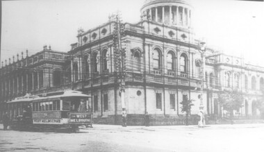
Black and white photograph taken while on board tram, of another tram heading up Pall Mall, destined for North Bendigo line. Post Office, Law Courts and City Family Hotel are all visible ion the background. Stamped in black on the back of photo: Photograph by Claver P. Carroll 79 Eaglehawk Road Eaglehawk. No. TR25. There are two copies of this photo.Claver P. Carrollbasil miller, bendigo trams -
 Melbourne Tram Museum
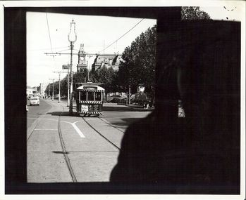
Photograph, Cable tram 364 Lonsdale St at William St, 1890s
The photograph shows a cable tram in Lonsdale St crossing William St. Alf Twentyman in his notes has identified it as West Melbourne trailer 364. In the background is the Supreme Court building and a tangle of telephone wires.Yields information about cable trams in the 1890s.Photograph, black and white, with notes on the rear.On rear in blue ink "West Melbourne 364 probably early 1890s, later became North Melburne No. 4"trams, tramways, cable tram, tram 364, lonsdale st, william st, supreme court -
 Stawell Historical Society Inc
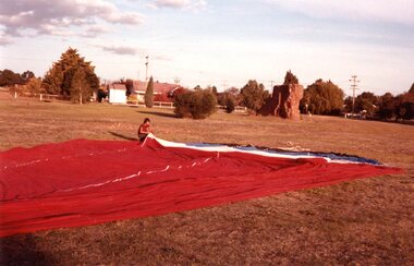
Photograph, Aerial Photos of Stawell from a Hot Air Balloon 1985 -- 12 Photos
Series of 12 Aerial Photos of Stawell. Hot Air Balloon 1985. Photos taken during hot air balloon rides May & June 1935. The rides left from land near leisure complex, Houston St and Newington Rd corner. The rides first over Stawell and drifted towards the Black Range. This vacant site is now the location of Stawell indoor heated and outdoor pools. 1 & 2. Setting up balloon. 3. North Park Area Lamont St. 4. Netball & Tennis courts Athletic track. 5 Wimmera St, Trotting track & Drive-in Scallan St. & Main St. 6. State School 502 Jenning-Campbell & Houston St's. 7 Ligar St. crosses Campbell & Houston St's. 8. Ord St, 502 School yard. 9. Central Park Napier, Wakeham & Shirreff St's also Railway & Foot Bridge. 10. Central Park. 11. Sloane St. on left Trotting track & Drive-in. 12. The Old Lake oval. Series of twelve photos mostly consisting of aerial photos and two of a large balloon on the ground. stawell -
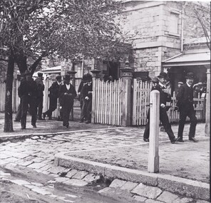 The Beechworth Burke Museum
Photograph, c1860
The photo depicts men dressed in formal suits and in bowler hats walking out the front of the Beechworth Court House. Beechworth became known as the legal headquarters of north-east Victoria after the establishment of the Circuit Court in 1857. This was later known as the Court of Assize and dealt with cases surpassing the reach of the General Sessions and County Courts. The Court House was built a year after for these proceedings and was extended in 1865. As the image is undated the year is not known, however it can be assumed it was taken after 1857 as the Court House is pictured.The photograph holds historic significance as it contributes to an understanding of the legal systems in Beechworth at that time. Specifically, the popularity of the Court House as a large number of people are pictured in the photo, which may represent the frequent use or interest in a signifiant trial that may have occurred at the place.Black and white landscape photograph printed on paper.beechworth courthouse, court house, beechworth, bowler hats, trial, legal, law, court, proceedings, circuit court, court of assize, assize, county courts, general sessions