Showing 1066 items matching "over the river"
-
 Melbourne Tram Museum
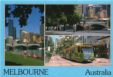
Postcard, Bartel Postcards, three photos of Melbourne scenes, early 1990's
... - Bartel Postcards: 1 - View of Melbourne over the Yarra River...: 1 - View of Melbourne over the Yarra River 2 - Princes ...Colour postcard 3 photo panels, blue border, divided back - Bartel Postcards: 1 - View of Melbourne over the Yarra River 2 - Princes Bridge 3 - B2 2013 in Bourke St, East Brunswick, Route 96 Back has space for name and address, stamp and a message and details of the postcard. Produced by Bartel Postcards possibly early 1990's Card No. BG318 Has "Melbourne Australia" along the bottom edge. Two copies held.trams, tramways, bourke st, mall, b class, tram 2013 -
 Ballarat Tramway Museum
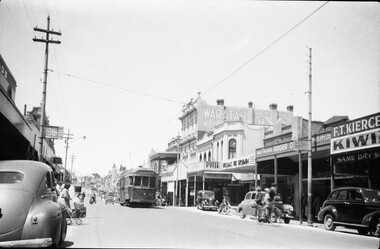
Photograph - Black & White Photograph/s, Negative, Ellis Collection, c1950
... side of the street. c1950. Note the road lifting over... lifting over the Yarrowee River bridge. The two signs on either ...Yields information about the appearance of Bridge St and the use of the trams c1950.Black and white photograph of a bogie tram 22 west bound in Bridge St. Has a group of ladies on either side of the road waiting to board? Note the signs on the poles on either side of the roadway. Has the Waratah Motors, Roger David stores on the west side of the street. c1950. Note the road lifting over the Yarrowee River bridge. The two signs on either side of the road "No Parking over 1 hour Park 1 Foot from kerb" Negative number 1140. Negative scanned at 2400dpi. On the top edge of one of the prints "same as 1094"trams, tramways, ballarat, bridge st, signs, tram 22 -
 Wangaratta Historical Society
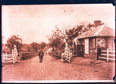
Toll Gates, Wangaratta Toll Bridge, Mid 19th Century
... and the new bridge over the Ovens river was opened in 1855; a charge... was sunk and the new bridge over the Ovens river was opened in 1855 ...Wangaratta Toll Gates were erected after the punt was sunk and the new bridge over the Ovens river was opened in 1855; a charge was made for people, animals, carts, cars and buses and trucks later on. A gatehouse keeper lived in a residence near the gates to charge users when they crossed. The gates were refurbished by the students at the local GOTAFE college and are being rehoused as a feature of the river beautification works along the Ovens River.The Toll Gates were on the first (and only bridge at the time) that crossed near the junction of the Ovens & King rivers at Wangaratta in the mid 1800's. They are a vital part of the city's heritage.Two white timber gates, hung on white timber posts by metal hinges. wangaratta toll gates -
 Kiewa Valley Historical Society
Photograph - Folder of Photographs – Photocopied set of 10 black and white photographs (pages 19 - 28) from the display folder put together by KVHS to document life on the Kiewa Valley Hydro-electric Scheme
... house – 1950 4-Bridge over Pretty Valley River, Bogong 5-Rocky... No K6331 Kiewa Hydro Electric Works Bogong-Bridge over Pretty... Hydro Electric Works Bogong-Bridge over Pretty Valley River ...Although the Kiewa Hydro-Electric Scheme was first proposed in 1911, construction did not commence until 1938. As part of the push to cut electricity costs and diversify supply, the Victorian Government (circa 1930) initiated the conversion from primarily brown coal supply to hydro – electricity. Field investigations during the 1940’s resulted in a new proposal for a scheme that had more than double the capacity of the 1938 scheme. The Kiewa Hydroelectric Scheme became the largest scheme of its kind in the State Of Victoria and the second largest scheme in Australia. The number of personnel involved in the planning and construction of the scheme increased dramatically. During the late 1940’s, most activity centred around the construction of the West Kiewa Power Station, Rocky Valley Reservoir, McKay Creek Power Station and the Bogong Creek Aqueduct.A common thread across all the larger hydro scheme constructions was the need for workers, both qualified and unqualified who came from around the world seeking a new life for themselves and their families. New accommodation and facilities were required for the army of workers engaged in construction in often remote and wild areas. The SEC had a high demand for timber, and set up the first of a number of sawmills at Bogong Creek in 1939 and set up the first hardwood logging in the headwaters of the Kiewa River. These new ‘towns’ such as Mt Beauty and Bogong, survived, serving the needs of operational personnel and their families, and expanding with growth of new industries. Mount Beauty, and to a lesser extent Bogong, are among these places. Large A3 size spiral bound display folder containing 21 pages of photocopied black and white photographs of various aspects of the early days of the Kiewa Valley Hydro-electric scheme including equipment, various work sites and photographs of workers and their families. 1-Allis Chalmers Tractor School 2- Gardens outside Administrative Office – Mt Beauty 3- Mt Beauty house – 1950 4-Bridge over Pretty Valley River, Bogong 5-Rocky Valley Spillway Tunnel break through 6-Ni 1 Headrace Tunnel drilling face 7-No 4 Power Station Drilling 8-Clover Dam Flood Waters 9-No1 Head Race Tunnel Portal Building 10-Clover Dam 1-STATE ELECTRICITY COMMISSION OF VICTORIA Date: 5.9.49 Time: 10amm No K5174 Kiewa Hydro Electric Works Allis Chalmers Tractor School Page number 19 2-STATE ELECTRICITY COMMISSION OF VICTORIA Date: 22.2.50 Time: 3.30pm No K5601 Kiewa Hydro Electric Works Gardens outside Administrative Office – Mt Beauty Page number 20 3-Mt Beauty house – 1950 Page number 21 4-STATE ELECTRICITY COMMISSION OF VICTORIA Date: 23.10.50 Time: 11.15am No K6331 Kiewa Hydro Electric Works Bogong-Bridge over Pretty Valley River Page number 22 5-STATE ELECTRICITY COMMISSION OF VICTORIA Date: 23.6.50 Time: 2.30pm No K5844 Kiewa Hydro Electric Works ROCKY VALLEY SPILLWAY TUNNEL BREAK THROUGH Page number 23 6-20/3/52 – No. 1 Headrace Tunnel Drilling face (E.E.E. contract) Page number 24 7-6/6/52 – No 4 Power Station – Drilling Page number 25 8-STATE ELECTRICITY COMMISSION OF VICTORIA Date: 6/6/52 Time: No K7113 Kiewa Hydro Electric Works Clover Dam Flood Waters Page number 26 9-STATE ELECTRICITY COMMISSION OF VICTORIA Date: Oct 1952 Time: No K7239 Kiewa Hydro Electric Works No. 1 HEAD RACE TUNNEL PORTAL BUILDING. Handwritten underneath – This information from Ron White-the later Principal Hydro Engineer of the SEC. Oct 1952 Location incorrect? All work on No 1 had ceased after financial crash of 1951. This photo would refer to No 4 Headrace Tunnel? Page number 27 10-STATE ELECTRICITY COMMISSION OF VICTORIA Date: Jan 1953 Time: No K7307 Kiewa Hydro Electric Works CLOVER DAM Page number 28 secv; kiewa hydro electric scheme; bogong; mt beauty; construction area -
![Sketch - Digital image, William Poulter's Bonnie Vale [sketch], 1925c](/media/collectors/4f729f5697f83e03086015b8/items/54d0485a2162f10e70db9490/item-media/54d0489e2162f10e70db9ed3/item-fit-380x285.jpg) Greensborough Historical Society
Greensborough Historical SocietySketch - Digital image, William Poulter's Bonnie Vale [sketch], 1925c
... , over the Plenty River is the house property known as 'Blackjack... of Poulter Reserve, over the Plenty River is the house property known ...Copy of sketch of William Poulter's property "Bonnie Vale". William Poulter and his wife Mary arrived in Victoria in 1849 and settled in Greensborough in 1853, constructing "Bonnie Vale" soon after their arrival. The old house was completely destroyed by fire circa 1960. Bonnie Vale, if existent in modern times would have been found in south eastern centre of Poulter Reserve, over the Plenty River is the house property known as 'Blackjack' on 59 Hume Street.Greensborough pioneer family Digital copy of black and white sketch. -
 City of Greater Bendigo - Civic Collection
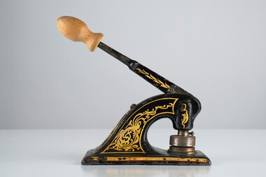
Ceremonial object - Common Seal
... over the Loddon River for gold diggers en route... over the Loddon River for gold diggers en route ...Bridgewater is a situated 39km northwest of Bendigo and 170 km from Melbourne. It was established as a crossing point over the Loddon River for gold diggers en route to the Inglewood gold diggings. As gold began to dry up in the district the town of Bridgewater developed due to its proximity to the river which it relied on for industries such as brewing, farming and market gardens. As demand on the water supply grew, the Water Works were established to ensure supply and manage the quality of the water for drinking. Decorated hand operated cast iron embosser with 40mm seal head attached. Gold and orange painted decorations extend from top edge of handle to sides of base. Original knob has been replace with a newer wooden knob. Well used showing all over signs of wear. Seal is for the Bridgewater Waterworks Trust 1927.Bridgewater Waterworks Trust 1927.loddon shire -
 Melbourne Tram Museum
Slide - set of 3, Chris Jacobson, Z class tram No 1, May 1975
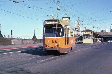
... Elgar Road. 2 - In Wallen Road, just over the Yarra River Bridge... - In Wallen Road, just over the Yarra River Bridge at Hawthorn 3 ...Set of three Colour slides of a new Z class, No. 1 tram dated May 1975. The tram entered service on 5/5/1975 - see reference. 1 - Leaving Batman Ave terminus, route 70 for Wattle Park Elgar Road. 2 - In Wallen Road, just over the Yarra River Bridge at Hawthorn 3 - Swan St - Batman Ave intersection with the Olympic Swimming pool in the background along with a W class running a route 77.Yields information about Z class 1 and Batman Ave terminus.Set of 3 Kodachrome colour slides, cardboard mount.All have "Chris" in ink on the rear.tramways, z class, new tram, tram 1, batman ave, route 70, wallen road -
 Orbost & District Historical Society
railways envelope, C 1980's
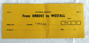
... of the river, in order to save on the costs of a bridge over the river... of the river, in order to save on the costs of a bridge over the river ...This item was used by Victorian Railways 1970's/1980's. It was used at Orbost Railway Station for the consignment of timber from Orbost to Westall.. Westall was a major timber-receiving depot near Dandenong, Victoria. Westall railway station is located on the Pakenham and Cranbourne lines in Victoria, Australia. It serves the south-eastern Melbourne suburb of Clayton South, opening on 6 February 1951. Westall station was opened as a workers only platform on 16 October 1954. It was provided for the adjacent Martin & King railway coachbuilding factory. The station was opened to the public on 1 June 1959 when all trains on the line began stopping there. The Bairnsdale-Orbost railway was opened in 1916 to serve the agricultural and timber industry. Because of the decline in traffic and heavy operating costs, the line was finally closed in August, 1987. Orbost Railway Station was opened on Monday 10 April 1916 as the terminus of the Orbost railway line, and closed in 1987. The station was located on the west side of the Snowy River despite the town of Orbost being on the east side of the river, in order to save on the costs of a bridge over the river, which at the time had highly variable levels. This item is associated with the history of the Orbost-Bairnsdale railway line and therefore reflects the role that the rail line played in the social and economic history of Orbost.An unused brown/buff coloured goods/freight consignment envelope used by Victorian Railways, this one for timber from Orbost to Westall. It is DL size.2497-78 VICTORIAN RAILWAYS G.F 63 From ORBOST to WESTALL MASS Tonnes kg Vehicle No Contents TIMBER Consignee Date orbost-bairnsdale-railway westall -
 Eltham District Historical Society Inc
Photograph, Doug Orford, Completion of bridge works across Yarra River at rear of Eltham Lower Park, August 2004
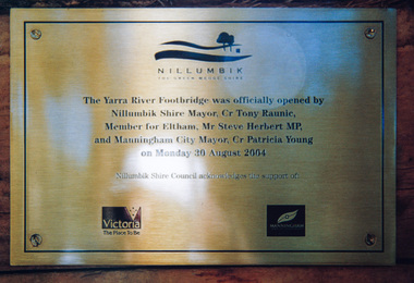
... lovely views over the Yarra River.... lovely views over the Yarra River. bridges yarra river eltham ...Plaque commemorating the opening of the Yarra River Footbridge opened by Nillumbik Shire Mayor Cr. Tony Ranuic, Member for Eltham, Mr Steve Herbert MP, and Manningham City Mayor, Cr. Patricia Young on Monday 30 August 2004. Nillumbik Shire Couuncil acknowledges the support of the Victorian State Government and City of Manningham. The footbridge links the Diamond Creek Trail between the Shire of Nillumbik and City of Manningham. It is a shared pathway and also links with the Main Yarra Trail. It affords lovely views over the Yarra River.One of three colour photographsbridges, yarra river, eltham south, eltham lower park, lenister farm, homestead road, plaque, yarra river footbridge, steve herbert, tony ranic, patricia young -
 Eltham District Historical Society Inc
Newsletter, Newsletter, No. 230 October 2016
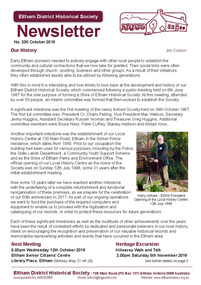
... of Maroondah Aqueduct Pipe Bridge over the Plenty River... of Maroondah Aqueduct Pipe Bridge over the Plenty River ...Contents: • Our History by Jim Connor • Our Next Meeting - Wednesday 12th October • Heritage Excursion - Kileavey Walk and Talk - Saturday 5th November • The Festive Reason by Mal Harrop • History of Maroondah Aqueduct Pipe Bridge over the Plenty River at Greensborough by Anne Paul • One Hundred Years Ago: Eltham and District - July-December 1916 by Liz Pidgeon • From the Hurstbridge Advertiser 2 March 1923 • Refurbishment of our Local History Centre • ... and also • Contacts for the Eltham District Historical Society The Shire of Eltham Historical Society was formed in October 1967. The first newsletter of the Society was issued May 1978 and has been published continuously ever since on a bi-monthly basis. With the cessation of the Shire of Eltham in late 1994, the Society's name was revised to Eltham District Historical Society and this name first appeared with issue No. 103, July 1995. The collection of the Society's newsletters provides a valuable resource on the history of the Society's activities, office bearers and committee members, guest speakers and subjects of historical interest pertinent to the former Shire of Eltham and the Eltham District.A4 photocopied newsletter distributed to membersnewsletter, eltham district historical society, shire of eltham historical society -
 Federation University Art Collection
printmaking - Acquatint, Sara Bowen, 'Reeds/Juanbung' by Sara Bowen, 2008
... into abstracted curves of water that run over river banks and among... that run over river banks and among islands of reeds. This item ...Sara Bowen (1966 - ) Born England. Arrived Australia October 2006. Artists' Statement: Reeds/Juanbung is part of a series of prints centred on the looded country where the Murrumbidgee and Lachlan rivers meet. Unmapped and unmappable, with no fixed landmarks, it fascinates me. early drawings have evolved into abstracted curves of water that run over river banks and among islands of reeds. This item is part of the Federation University Art Collection. The Art Collection features over 1000 works and was listed as a 'Ballarat Treasure' in 2007.Sugarlift acquatint with blind embossing.art, artwork, sara bowen, etching, printmaking, embossing -
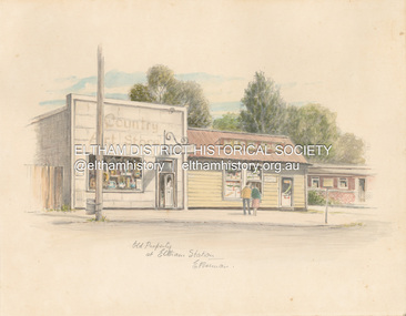 Eltham District Historical Society Inc
Artwork, other - Sketch, E. Foreman, Old property at Eltham Station, c.1980
... was taken over as River Clay run by Leo Haanappel and Coeny Dommers... was taken over as River Clay run by Leo Haanappel and Coeny Dommers ...Situated at 965 Main Road adjacent to the Eltham Railway Station, the Country Art Store was originally a hairdresser and Tattersalls agency In 1968 Pam Robinson and Caroline Shenton opened a small shop on the corner of Main Road and Napoleon Street. Four months later a damaged fire hyrdant flooded the store and ruined all their stock. The pair moved to the former hardresser shop at 965 Main Road, adjacent to the Eltham Railway Station, opposite the Stationmaster's house and opened the Country Art Store and adjacent gallery. At the time the only other shop selling pottery was the Potters Cottage in Warrandyte. During the 1970s the gallery was the Wiregrass Gallery. In 1993, after 25 years operating the Country Art Store, the pair decided to sell up and move to warmer climates. During the course of their business a number of craft shops and galleries opened and closed in Eltham. One such shop was Bimbadeen, next to Ansell and Muir's chicken shop opposite Eltham Lower Park. That business run by Don Brown, then a local artist was taken over as River Clay run by Leo Haanappel and Coeny Dommers but ultimately sat in a flood plain and was demolished. When the Country Art Store became available in 1993, Leo Haanappel and Coeny Dommers took it over. The premises became Platform 3095 cafe around 2015.Old Property at Eltha Station E. Foremanart store, country art store, country art store (eltham), eltham railway station, platform 3095, restaurants, shops, wiregrass gallery -
 Orbost & District Historical Society
black and white photograph, C1890
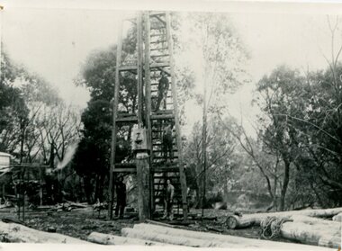
... over the Snowy River at Orbost being built. a copy was also... over the Snowy River at Orbost being built. a copy was also ...This photograph shows the construction of the first bridge over the Snowy River at Orbost being built. a copy was also donated by Gil and Heather Richardson. The first pile bridge over the Snowy River was just completed by Mr Jim Granter when the 1891 flood took out the centre,. There were differences of opinion as to whether the council should pay . The Shire Secretary, Mr John Draffin, persuaded them to honour their obligations. Mr Granter and Mr Clarke finished it as a suspension bridge which was opened by Mrs William Watt. Soon after a mob of cattle stampeded, the weight snapped the cable, letting one side sag. Mr R.P. Cameron repaired it and this bridge remained until 1922. "In 1890 the contract for a bridge was let to Mr James Granter for £1450. This structure with additions and improvements made to it was to cost the ratepayers about £2,500, and its erection was proceeded with in a very satisfactory manner until, just as the greater-part of the work had been completed, the flood of 1891 came down on it, piling up mountains of logs, timber and debris against the piers, which had not been made wide enough apart to allow for. contingencies of this kind. The structure held out bravely until the turn of the flood and then gave way with a crash, about five bays from the centre disappearing in the stream." ( Snowy River Mail August 12 1893)This is a pictorial record of the construction of the first bridge over the Snowy River.A black / white photograph of four men working on the construction of a new bridge and its pylons a man is standing on a timber tower/ derrick. There are logs in the foreground, trees in the background. sheds on the left and possibly a steam engine.on back - "first bridge - 1st pile being driven"snowy-river-bridge granter-jim bridge -
 Orbost & District Historical Society
black and white photograph, Howard D. Bulmer, first half 20th century
... A new bridge over the Snowy River at Orbost was opened... gippsland A new bridge over the Snowy River at Orbost was opened ...A new bridge over the Snowy River at Orbost was opened for traffic on June 20th 1922. It was intended as a road and rail bridge, and was again partly washed away by flood waters in 1934. After the end of the first World War the Victorian Railways considered an extension of the railhead across the river at Orbost, and in 1922 a new timber and steel girder structure, a joint Country Roads Board — Victorian Railways venture, was built and completed at a cost of £41,000 (the steel girders came from the Flinders Street viaduct reconstruction). Subsequently it was decided decided not to take the railway across the river, and the bridge was only used by road traffic. This is a pictorial record of an early bridge over the Snowy River at Orbost.A black / white postcard photograph of a bridge across a shallow river with men on horseback underneath.snowy-river-bridge -
 Bendigo Military Museum
Album - ALBUM, PHOTOGRAPH WW2
... . There are no embarkation dates recorded but on 1.6.44 repairing a bridge over.... There are no embarkation dates recorded but on 1.6.44 repairing a bridge over ...Cyril Raymond Scarborough PRE WW2 served in 38th BN Militia 1921-1938. From 1939 h tried to join the RAAF as “Carpenter General” his trade, rejected several times no position available. Finally accepted on 26.2.42 age 37 plus years No 51255. There are no embarkation dates recorded but on 1.6.44 repairing a bridge over the Raku River Aitape during enemy action and occupation he crushed his right foot and was hospitalised in New Guinea returning to duty on 16.10.44. At the end he enlisted in the “Interim Army” from 24.7.46 and went on to serve in BCOF Japan. He was discharged with the rank of CPL on 31.5.48 Photo album, heavy cardboards cover with red fabric covering, held together by cloth fabric, front has a Japanese layered depiction of a person, has 48 pages of photos taken at Australia, Morotai , Labuan and Japan. Inside front cover “ CYRIL R. Scarborough, 5 ACS RAAF/ WAKUNI Japan” Page 3 “ on tour 21.1.46 to 26.6.47 Australia, Ambou, Morotai,Labuan, Japan” , albums, photographs, ww2, japan -
 Orbost & District Historical Society
folder, Orbost Bridges - Snowy River Road Bridges, 1974 1976
... involving not only a new bridge over the Snowy River (including... involving not only a new bridge over the Snowy River (including ...This folder was compiled in October 2015 from documents, magazines. papers and photographs donated by David Jellie, engineer in charge 1974 - 1976. In early 1974, as an Engineer with the Country Roads Board, David came to Orbost as the Supervising Engineer for the construction of the new bridges which were part of an 8.4km Orbost bypass road design. This was a major project involving not only a new bridge over the Snowy River (including Lochiel Lagoon), but other bridges over Ashby’s Gulch and Watt’s Gulch. These new bridges were opened in November 1976 with the unveiling of a plaque on the eastern end of the $2.4M Snowy River Bridge. (ref. May Leatch)This item is a useful reference tool on the construction history of the Snowy River Road bridges.A white plastic folder - Orbost Bridges - Snowy River Road Bridges. it contains newspaper articles, booklets, photographs and documents relating to the construction of the Snowy River Road Bridge in 1974 -1976.on front cover - 1974 - 76 ORBOST / SNOWY RIVER ROAD BRIDGES * construction * photos * articles * plans Donated by David Jellie Oct 2015snowy-river-bridges jellie-david -
 Orbost & District Historical Society
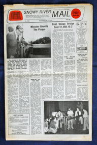
newspaper, Snowy River Mail, 1.12.1976
... a new bridge over the Snowy River (including Lochiel Lagoon... a new bridge over the Snowy River (including Lochiel Lagoon ...In early 1974, as an Engineer with the Country Roads Board, David came to Orbost as the Supervising Engineer for the construction of the new bridges which were part of an 8.4km Orbost bypass road design. This was a major project involving not only a new bridge over the Snowy River (including Lochiel Lagoon), but other bridges over Ashby’s Gulch and Watt’s Gulch. These new bridges were opened in November 1976 with the unveiling of a plaque on the eastern end of the $2.4M Snowy River Bridge. The new bridge, built by the CRB at a cost of $2.4 million, is 1.6 metres above the record flood levels of 1971. (ref. May Leatch) This newspaper contains contemporary reports of a significant event in Orbost.A Snowy River Mail newspaper, dated 1.12.1976. It contains news articles, photographs and advertisements. The main article relates to the official opening of the Snowy River Bridge and the unveiling of a plaque on the eastern approach. It also contains a history of the first Snowy River Bridge.snowy-river-bridge orbost-bridges snowy-river-mail -
 Orbost & District Historical Society
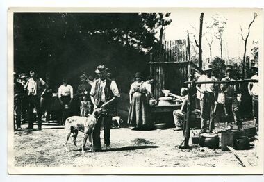
black and white photograph, C1914
... of the river, in order to save on the costs of a bridge over the river... of the river, in order to save on the costs of a bridge over the river ...This is a photograph of a railway camp, set up to house workers and their families when building the Bairnsdale to Orbost Railway from 1914-1916. The man in the foreground was one of three men killed in an explosion "noon on the railway construction works at Hagen's Cutting, about two miles from Orbost, three men being killed. The victims were John Carroll, con- tractor, his son, Peter Carroll, and John Sullivan, a navvy. The gang had just finished work, and the three stayed behind to draw a blasting charge, which had missed fire yesterday. J. Carroll was using a pick, and it is presumed that the tool struck a percussion cap, and fired the charge. He and Sullivan were killed instantly, Carroll being literally blown to pieces. Fragments of his body and garments were recovered from the surrounding bush, and the main portion of the trunk, with leg attached, was hurled a distance of 200 yards. Peter Carroll was terribly- injured, and he died before medical aid arrived." (from The Mercury Saturday March 114 1914) The Bairnsdale-Orbost railway was opened in 1916 to serve the agricultural and timber industry. Because of the decline in traffic and heavy operating costs, the line was finally closed in August, 1987. Orbost Railway Station was opened on Monday 10 April 1916 as the terminus of the Orbost railway line, and closed in 1987. The station was located on the west side of the Snowy River despite the town of Orbost being on the east side of the river, in order to save on the costs of a bridge over the river, which at the time had highly variable levels. This item is associated with the history of the Orbost-Bairnsdale railway line and therefore reflects the role that the rail line played in the social and economic history of Orbost.A black / white photograph of a campsite. There is a kitchen outside a rough construction. Men and women are standing in the backgroundd with one man and a dog in the foreground.on back - "Man with dog killed in explosion"orbost-railway transport railway-bairnsdale-orbost explosion-railway -
Peterborough History Group
Newspaper articles pertaining to Peterborough from 1990 to 1999
... Flooding at Peterborough 28/6/1994 Residents undecided over River... to Peterborough - river flooding and quality, concerns over council ...Various newspaper articles kept by Mrs Dawn Irvine, all pertaining to Peterborough - river flooding and quality, concerns over council boundary realignment. Article titles: 6/10/1992 Flooding at Peterborough 28/6/1994 Residents undecided over River 4/7/1994 Letter from Warren Moore. Peterborough is alive, the way residents like it. 26/12/1994 Letter from R. Irvine. Apprehension over changes 17/6/1998 Algae fear prompts call to open Curdies River 13/4/1999 Battlelines on the Curdies 14/4/1999 Peterborough residents urge BHP to find alternative waste disposal optionHistoric overview of the towns' concerns at that time. Seven newspaper cuttings of various sizes all regarding aspects of Peterborough. Includes objection to BHP discharging waste into the Curdies River and flooding. warren moore, ronald irvine, curdies river, moyne council, council boundary realignment, curdies river flooding, floods, peterborough, blue green algae, river quality, bhp waste management, bhp -
 Orbost & District Historical Society
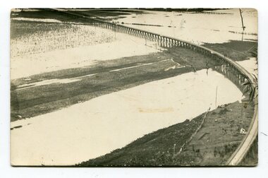
black and white photographs, second half 20th century
... 3154.1 is a postcard of the Orbost viaduct over the flooded... gippsland 3154.1 is a postcard of the Orbost viaduct over ...3154.1 is a postcard of the Orbost viaduct over the flooded Snowy River flats. 4153.2 is of a goods train on the viaduct. 3154.3 is of a loaded goods train with the driver at the window. Two men are standing on the plate and there are two workers below where there is some water and flood debris. 3154.4 is of amachine moving flood debris on the rail line. 3154.5 shows flood damage to the viaduct across the Snowy River flats. Two men are driving a dozer.This item is associated with the history of the Orbost-Bairnsdale railway line and therefore reflects the role that the rail line played in the social and economic history of Orbost.Five black / white photographs associated with the Orbost railway line during a flood.orbost-railway east-gippsland -railway orbost-floods -
 Melbourne Tram Museum
Pamphlet, Yarra Trams, "Your new accessible tram stops", Apr. 2007
... over the Yarra River - has map. 2 - 3 fold DL for stops 38, 42... 96, 109, and 112 - on the Specert St Bridge over the Yarra ...Set of five Pamphlets - DL - 3 fold, full gloss paper titled "Your new accessible tram stops" about the introduction in April 2007 of upgrades stops in Burwood Highway - stops 59, 61, 62, and 63 to Superstops. Has VicRoads logos as well as Vic Government and Yarra Trams. Two copies held. 1 -2 fold DL - for stops 124A on routes 96, 109, and 112 - on the Specert St Bridge over the Yarra River - has map. 2 - 3 fold DL for stops 38, 42, 48 and 52 Dandenong Road - Nov. 2007 3 - 3 fold DL for stops 22, 23, 24 and 26 Queens Parade Fitzroy North, Nov. 2008 4 - 3 fold DL for stops 53 to 59 - Matthews Ave Airport West April 2008trams, tramways, yarra trams, burwood, vermont south, superstops, route 75, spencer st, route 96, route 109, route 112 -
 Melton City Libraries
Photograph, Melton Railway Bridge, c.1884
... , lattice girder trestle bridge over the Werribee River (now Melton... girder trestle bridge over the Werribee River (now Melton ..."The Melton Viaduct, opened in 1886, is of State heritage significance as a very large and visually distinctive wrought iron, lattice girder trestle bridge over the Werribee River (now Melton Reservoir). It comprises 18.3 and 9.1 metre spans, in a generally alternate arrangement, of total length 375 metres, and standing 38 metres over the Werribee River. Wrought iron small section iron was used to build tension trussed trestle legs, which supported four lines of rivetted wrought-iron deck-type double lattice trusses. It has bluestone abutments and pier bases of coursed rock-faced bluestone with drafted margins. The larger half-piers, now usually submerged in the Melton Reservoir have sharp tapered cutwaters and curved coping at the tops. While designed to carry two rail tracks it has only ever been used as a single track line. Despite several alterations to its deck structure, it remains an outstanding example of a lighter structural design employing open metal trestle supports and metal truss girders. The direct Melbourne to Ballarat railway link of which the Melton viaduct was the major engineering work contributed significantly to the history and development of Victoria. This new link reflected Ballarat’s diversifying economy as well as the commercial and political influence of the metropolis. Construction of the bridge, and the associated large workers camp, were extensively photographed, documenting an important episode in local history. The railway enabled the development of new industries in the Melton area, notably the timber industry and a chaff industry of national importance, greatly facilitated the later transition of the Shire from a pastoral to a farming economy, and struck a major blow to Melton township’s era as a wayside town servicing Ballarat road (especially coach) traffic". Melton Railway Bridge being built across the Werribee Rivertransport -
 Greensborough Historical Society
Photograph - Digital Image, Aqueduct Greensborough, 1960c
... the wrought iron aqueduct pipes over the Plenty River. The use... to carry the wrought iron aqueduct pipes over the Plenty River ...The Pipe Bridge at Greensborough is a significant and highly visible part of the system. It was constructed to carry the wrought iron aqueduct pipes over the Plenty River. The use of wrought iron meant the pipes were 75% lighter than cast iron, with the bridge construction reflecting this innovation. Photograph of the Maroondah Aqueduct pipe bridge at Greensborough. The Pipe Bridge is 210 feet long, divided into 4 spans. The main girders are light lattice 11 feet deep and 11 ft 4 inches apart. The bridge carried two wrought iron tubular mains, 53 inches in diameter, supported at intervals by cross girders and chairs, placed between the main girders. The bridge is carried on braced cast-iron columns, 18 inches in diameter, set on concrete foundations, with a clear headway of 20 feet above the Plenty River. The eastern side of the bridge is reinforced with a bluestone abutment at the river bank.Digital copy of colour photograph.maroondah aqueduct, aqueduct pipe bridge greensborough -
 Orbost & District Historical Society
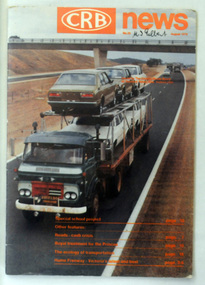
magazine, CRB News, August 1976
... River (including Lochiel Lagoon), but other bridges over Ashby’s... River (including Lochiel Lagoon), but other bridges over Ashby’s ...By 1910 it had become apparent that there was a need for a central roads authority to take over responsibility from the Board of Lands and Works for the care and management of the main roads of the state of Victoria. Because there was no consistent and systematic policy for road maintenance Victorian roads were in a deplorable condition. At this time the use of the motor car accentuated the demands for better roads. As a result of these needs the Country Roads Act 1912 was proclaimed in 1913 providing for the establishment of the Country Roads Board as a central road authority with responsibility for those roads within the State considered to be main roads. the C.R.B. was responsible for the construction of roads and bridges including the Snowy River road bridges in Orbost. This was a major project involving not only a new bridge over the Snowy River (including Lochiel Lagoon), but other bridges over Ashby’s Gulch and Watt’s Gulch. These new bridges were opened in November 1976 with the unveiling of a plaque on the eastern end of the $2.4M Snowy River Bridge. (ref. May Leatch) This is a useful reference tool on the history of the construction of the Snowy River road bridges.A journal, titled "CRB News" . On the front cover the title is in orange print with No. 33 August 1976 above a coloured photo of a truck carrying two tiers of new vehicles along a main sealed road. It contains information and photos of the construction of the Snowy River road bridges.on front cover - handwritten in black - "M. I. Gilbert"crb-news country-roads-board snowy-river-road-bridges -
 Ringwood and District Historical Society
Book, A Burns Family History, 2019
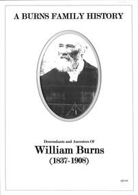
... at Burns Bridge 1.1.2 Renaming of Burns Bridge over Goulburn River... at Burns Bridge 1.1.2 Renaming of Burns Bridge over Goulburn River ...Descendants and Ancestors of William Burns (1837-1908) Compiled by Neville Burns (Great Grandson) and Meaghan Bosaid (GG Granddaughter).CONTENTS INTRODUCTION Chapter 1 - William Burns and descendants. 1.1 William Burns (Great Grandfather) 1.1.1 Bridge Inn at Burns Bridge 1.1.2 Renaming of Burns Bridge over Goulburn River 1.2 George Paul Burns (Grandfather) 1.2.1 Spouse 1.2.2 Sons 1.3 Clarence (Clarrie) Henry Burns (Father) 1.3.1 Spouse 1.3.2 Children 1.4 Neville Clarence Burns 1.4.1 Spouse 1.4.2 Children 1.4.3 Some Recollections of Early Ringwood Chapter 2 - Ancestors of William Burns 2.1 Summary of Ancestors of William Burns 2.2 Detail of each generation of Ancestors ACKNOWLEDGEMENTS In compiling this Burns History some of the information came from our own family records and recollections, but the greater input, particularly the early historical content, was obtained from the resources and records of organisations and Societies and other published material mentioned herein. I would like to acknowledge and thank Russ Haines and Members of the Ringwood and District Historical Society who unearthed the many photographic records of early Ringwood and the various articles related to the Burns family. I also thank the society for authorising the use of a number of relevant photographs, some of which appear in Hugh Andersons Book - Ringwood - Place of Many Eagles. Early information of the Burns family was also obtained from the Mansfield Historical Society and the Jamieson Historical Society and I thank the volunteer staff of both organisations for their help. Electronic files of the book added 15 October 2024 -
 Orbost & District Historical Society
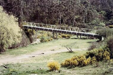
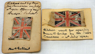
ribbon, 1922
... . This was the second bridge over the Snowy River. The first bridge.... This was the second bridge over the Snowy River. The first bridge ...They are both pieces of ribbon used for the opening of the snowy River Bridge on July 4 1922. The ribbon was made to represent the red, white and blue of the British flag. This was the second bridge over the Snowy River. The first bridge was officially opened in August, 1893 (ref. S.R.M. 12.8.1893) by Mrs W. Watt, the mother of Councillor Watt, who presided over the opening of the 1922 bridge. This bridge was extensively damaged when a herd of cattle allegedly stampeded over it causing the cable to snap. Even after repairs it became obvious that a new bridge was needed. This second bridge, was built by the Victorian Railways and the Country Roads Board. Constructed at a cost of 35,000 pounds and used second-hand girders from the Flinders Street- Spencer Street viaduct. On July 4 1922 it was officially opened by Mrs James Cameron. Unfortunately, her husband, who had long championed the building of the bridge so that it would be ready for the railway to continue to the border, was too ill to attend the ceremony. In fact, James Cameron died on July 13 after a long and severe illness (ref. S.R.M. 20.7.1922). Souvenirs kept by enthusiastic spectators like this have helped to preserve the history of an important Orbost event.Two pieces of ribbon in British flag pattern of red, white and blue. These have been pinned onto card with a handwritten description of their history.snowy-river cameron souvenir -
 Orbost & District Historical Society
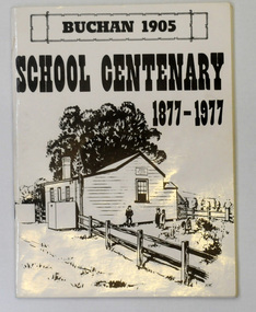
letter book, James Yeates & Sons (Printing) Pty Ltd, 1977
... the bridge over the Buchan River. This original school building must... the bridge over the Buchan River. This original school building must ...This book was prepared for the Buchan School centenary. In the Buchan District itinerant teaching was conducted in buildings with log walls and a bark roof typical of the mid 19th century. Not until 1878 was the first State school built on the same general site as the present school, on the Orbost Rd, ⅓ of a mile from the bridge over the Buchan River. This original school building must have been constructed from high quality timber, because it still serves as the shelter pavilion. On 11th of July 1878 William Scott opened the first school of approximately 40 pupils ranging from Grade 1 - 8. A larger weatherboard school was erected in 1914. A residence was provided for the HT in 1934 and in 1956 a second classroom erected and attached to the 1914 building. Unfortunately, all records of the Committee were lost in a fire when the homestead of Alex Cameron, then serving as Committee Secretary, was burnt to the ground, but it is well known to local citizens that Frank Moon, local prospector, explorer and discoverer of the famous Buchan Limestone Caves, attended school at SS1905 Buchan. (ref SCHOOLS EAST GIPPSLAND - John Phillips)This book is a useful research tool on the history of Buchan.Two copies of a 273 pp paper covered booklet. The cover is white with the title in black print. On the front is a sketch of an old school building. On the back is a black/white photograph of children running downhill. A book on the history of the Buchan school no.1905. Includes photographs, maps and lists of school students and staff.book buchan-history buchan-school -
 Wodonga & District Historical Society Inc
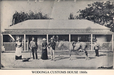
Photograph - Old Customs House, Wodonga, 1860s
... . Wodonga Customs House was built near the end of Union Bridge over... was built near the end of Union Bridge over the Murray River in 1859 ...Customs duties were a means of raising revenue between the 1850’s and Federation. They were first introduced by NSW in November 1854 after it was separated from the colony of Victoria three years earlier. J P Hanify was appointed as sub-collector at Belvoir, the official name present day Wodonga at that time. Wodonga Customs House was built near the end of Union Bridge over the Murray River in 1859 Tariffs or customs duties greatly angered residents and it was little wonder the customs officer of the day was always an unpopular man. Tariffs had to be paid on articles such as tobacco, many food items and new clothing that were carried across the Border. The range of items was extended over time, leading to some farmers even swimming their livestock across the river to avoid duties at the Customs house. The levying of duties ended with Federation in 1901. Francis Cobham depicted in this photograph, took up the position of Customs officer in 1867 and remained there until his retirement in 1890. The building was originally a 2 roomed custom house in 1856 but was extended to provide living quarters for the Cobham family while a nearby cottage became the Customs house. The building was moved to a position south of the lagoon in the mid 1980’s and is now a restaurant.This image represents an important stage in the development of colonial relationships and rivalries in Australia.Black and white photograph of Customs officer Francis Cobham in Wodonga c 1860customs house wodonga, albury wodonga border, colonial rivalry victoria /nsw, tariffs -
 Ballarat Heritage Services
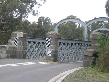
Photograph, Redesdale Bridge, 2016, 18/01/2016
... with bluestone abutments which was installed over the Campaspe River... over the Campaspe River in January 1868, although the bridge ...The Redesdale Bridge is a wrought iron and timber structure with bluestone abutments which was installed over the Campaspe River in January 1868, although the bridge actually bears the date 1867. In 1859, the "Herald of the Morning", a ship carrying a cargo including 350 tons of ironwork for the Hawthorn bridge, caught fire and was scuttled a quarter of a mile off the jetty at Sandridge. A Melbourne salvaging firm raised the ironwork from the bottom of the bay, but after details of an arranged sale to the government caused a scandal in Parliament, the material was sold privately to the Melbourne foundry Langlands & Co. Two hundred tons of it was sold to the goldfields shires of McIvor and Metcalfe for only £1000. The bridge was designed by engineer T.B. Muntz and built by a contractor named Doran, and was completed late and considerably over budget at £6274. The bridge spans 45.7m across the river and has two roadways which are carried between three metal lattice girders in a through truss configuration. The design for the Hawthorn bridge had the deck supported over the trusses, and to stiffen the through truss configuration three sets of distinctive paired arches connect the trusses above the roadways. The roadway decking is constructed of longitudinally placed timbers on timber cross girders which rest on the lower chords of the trusses. (Heritage Victoria) A number of colour photographs showing the historic bridge at Metcalfe.metcalfe, shire of metcalfe, bridge, municipal boundary, shire of mcivor, redesdale bridge, campaspe river, t.b. muntz, doran -
 Eltham District Historical Society Inc
Negative - Photograph, Warrandyte Bridge over River Yarra, c.1910
... Warrandyte Bridge over River Yarra...View of the 1875 timber trestle bridge over the Yarra River... Elliot to erect a bridge over the Yarra River at Warrandyte ...View of the 1875 timber trestle bridge over the Yarra River reproduced from a newsprint image. Also known as Anderson's Creek (Road) Bridge A contract was accepted for William Elliot to erect a bridge over the Yarra River at Warrandyte on Anderson's Creek Road and other improvements for £1,331.6.2 - Gazette No. 143. Tuesday, November 13th 1860 - http://gazette.slv.vic.gov.au/view.cgi?year=1860&class=general&page_num=2161&state=V&classNum=G143&id=). The bridge was washed away by floods in 1863. It was replaced with a taller timber trestle structure in October 1875, designed and built by C.S. Wingrove, Shire Clerk, Engineer and Surveyor for Eltham Shire Council. A replacement for this bridge was commenced in 1955 to cope with increasing traffic and this structure was widened in 2018 to meet further traffic demands. Argus (Melbourne, Vic. : 1848 - 1957), Thursday 23 September 1875, page 7 ________________________________________ THE WARRANDYTE BRIDGE. The ceremony of formally opening the newly erected bridge over the Yarra at Ander-son's Creek was performed on Monday last, in the presence of the members of the Eltham and Bulleen shire councils whose territories it joins, and a goodly number of the residents of the district. The task was delegated to Mr. Cameron, M.L.A., who, after a few introductory remarks declared the bridge to be opened, and christened it the " Warrandyte Bridge." The party then adjourned to Grant's Hotel, where a cold collation had been prepared. The chair was taken by the president of the Eltham shire (Mr. John Bell) and the vice chair by Mr. Kent, a member of the Bulleen council. Mr Robert Williamson proposed "Success to the bridge," coupling with it the name of Mr. Cameron, to whose exertions was in the main to be attributed the erection of that structure which was an ornament to the district and would prove of great service to both sides of the river. Mr. Cameron, in responding, alluded to the great difficulties, mainly of a pecuniary nature, that had been encountered in carrying out the project, and which had only been got over by their united efforts and by the liberal spirit in which the late Commissioner of Roads had dealt with the case. The healths of the contractor and the engineer were also drunk. The bridge is a trussed timber one, resting on yellow box piles sunk into the solid rock, each pier being weighted with 50 tons of stone. The abutments consist of dry stone walls, 6ft. thick at the base, and tapering to 3ft. on the top, the face of the work having a batter of 1 to 1. The length of the bridge is 308ft., there being four openings in the centre of 66ft. each, and two at the ends of 20ft. each. The width in the clear is 9½ft., and the height from the bed of the river about 33ft. The approaches comprise 1,100 cubic yards of earthwork, and the formation of 48 chains of sideling, the whole cost of the work, which was carried out under the direction of the engineer to the Eltham Shire Council, being £1,413.This photo forms part of a collection of photographs gathered by the Shire of Eltham for their centenary project book,"Pioneers and Painters: 100 years of the Shire of Eltham" by Alan Marshall (1971). The collection of over 500 images is held in partnership between Eltham District Historical Society and Yarra Plenty Regional Library (Eltham Library) and is now formally known as the 'The Shire of Eltham Pioneers Photograph Collection.' It is significant in being the first community sourced collection representing the places and people of the Shire's first one hundred years.Digital image 4 x 5 inch B&W Neg B&W Print 12.5 x 9 cmsepp, shire of eltham pioneers photograph collection, warrandyte, bridge