Showing 4521 items
matching park street
-
 Kew Historical Society Inc
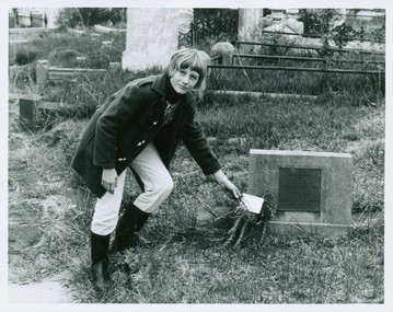
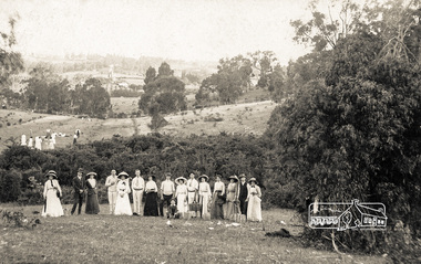
Photograph - Tour of the Boroondara (Kew) General Cemetery, 1977
... an unusual triangular reserve bounded by High Street, Park Hill Road... triangular reserve bounded by High Street, Park Hill Road ...Boroondara Cemetery, established in 1858, is within an unusual triangular reserve bounded by High Street, Park Hill Road and Victoria Park, Kew. By the 1890s, the Boroondara Cemetery was a popular destination for visitors and locals admiring the beauty of the grounds and the splendid monuments. The Boroondara Cemetery is of historical significance for the graves, monuments and epitaphs of a number of individuals whose activities have played a major part in Australia's history. They include the Henty family, artists Louis Buvelot and Charles Nuttall, businessmen John Halfey and publisher David Syme, artist and diarist Georgiana McCrae, actress Nellie Stewart and architect and designer of the Boroondara and Melbourne General Cemeteries, Albert Purchas.Walking tour led by Kew Historical Society members for members of the Royal Historical Society of Victoria in 1977. The photograph shows a Kew youth placing a sprig of Rosemary on Ellen Quick's grave. The photograph was one of six taken by KHS member Stewart West on that occasion, and subsequently donated by him to the collection by him.Reverse: "Kew youth placing a sprig of rosemary on grave of Ellen Quick nee Derrick who was the first burial on 12/3/1859. Her family Derricks were early Kew Landowners." boroondara general cemetery, kew cemetery, walking tours, ellen quick, dannock family, kew pioneers -
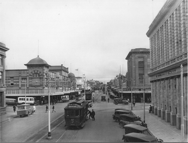
 Kew Historical Society Inc
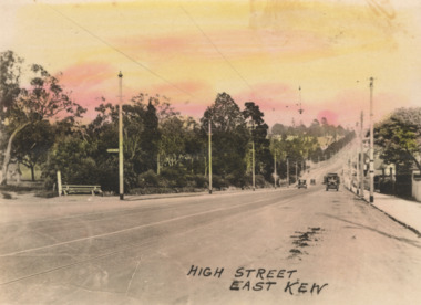
Postcard - High Street, East Kew, c.1927
... through the intersection of Studley Park Road, Denmark Street... through the intersection of Studley Park Road, Denmark Street ...High Street, Kew is the main Road in Kew. It was once also known as Bulleen Road, or Main Street. This section of the road is in Kew, although the narrow section on the right hand side of the photo is now Kew East. High Street progresses through a number of significant road junctions: beginning at Barkers Road; progressing through the intersection of Studley Park Road, Denmark Street and Princess Street at Kew Junction; branching left at the junction with Cotham Road; before reaching the junction with Valerie Street and Harp Road. It reaches its end at the junction of Burke Road, Kilby Road, Bulleen Road and High Street itself. An early photograph of this iconic Memorial that locates it in its context. Small, colorised real photo postcard of High Street, East Kew. Electric light poles line the road. Victoria Park is on the left and further on the horizon is the Boroondara General Cemetery.high street -- kew (vic.), victoria park, tram lines -- kew (vic.) -
 Ballarat Heritage Services
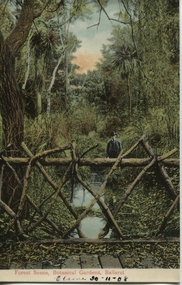
Postcard, Ballarat Botanical Gardens, c1908
... were the street plantings, parks and botanical gardens... City image were the street plantings, parks and botanical ..."Within six years of its first land sales in 1852, founder members had challenged council over horticultural decisions and Ballarat's main thoroughfare contained fences squares, trees and flower beds. The major works that projected the Garden City image were the street plantings, parks and botanical gardens ..." Reference: Michael Taffe, Growing a garden City: Ballarat Horticultural Society 1859-2009, BHS Publishing, 2014, p. 10.This postcard shows how the botanical gardens in Ballarat, famous for being a Garden City.Coloured postcard Forest Scene, Botanical Gardens, Ballarat printed in red at bottom of card. Elaine 30-11-08 handwritten in black ink underneath.botanical gardens, ballarat, forest scene, gardens, botanical, -
 Kew Historical Society Inc
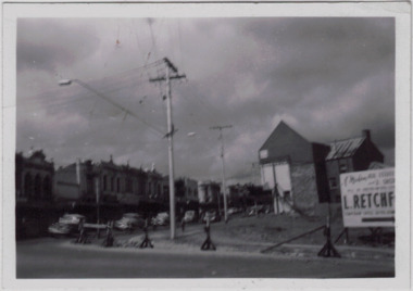
Photograph - Kew Junction during road widening, December 1958
... - Denmark Street, High Street, High Street South, Studley Park Road..., High Street, High Street South, Studley Park Road and Princess ...Kew Junction is the intersection of five major roads - Denmark Street, High Street, High Street South, Studley Park Road and Princess Street. The original widening of High Street in the 1930s expanded that street by removing shops on the south side of the street from Cotham Road to Denmark Street. Further widening in 1958 removed shops at the west end of High Street to allow for increased traffic using Princes Street and Denmark Street.Original, black and white positive of Kew Junction, including the corner with Denmark Street during road widening in the 1958.Inscribed verso: "Kew Junction Dec 1958 / When the road was being widened by the removal of a number of shops / Notice saying Retchford's Estate agency's temporary office is at the top end of Denmark Street, Kew"kew junction, denmark street -- kew (vic.), major roadworks -- kew (vic.) -
 Stawell Historical Society Inc
Postcard, Stawell Photographic Booklet
... : The Willows, Victoria Park 6: Central Park 7: Main Street Looking west...: Central Park 7: Main Street Looking west 8; The Sister Rocks 9 ...Letter containing the following To whom it may Concern, I located this photographic memento of Stawell & the Surrounding district amongst my late parents belongings and thought it may be of interest tp your group as a curio. I would be please if you would accept and retain it.Yellow card Cover containing 9 B/W Photo Scenes of Stawell and Surrounding landmarksFront Cover Stawell Photographic Booklet Rear Cover: From ..... Published by the Valentine Publishing Co. Pty. Ltd. Melbourne an d Sydney 1: Panorama of Stawell 2: The Pinnacle The Grampians 3: The Oval, Central Park 4: Grand Canyon, The Grampians 5: The Willows, Victoria Park 6: Central Park 7: Main Street Looking west 8; The Sister Rocks 9: Rounda, Victoria Park STAWELL. Victoriatourism postcards -
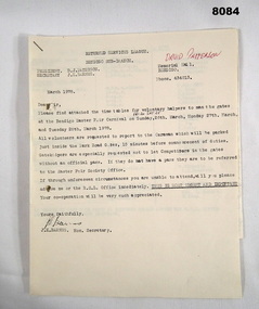 Bendigo Military Museum
Administrative record - RSL ROSTER EASTER FAIR 1978, Bendigo RSL Sub Branch, March 1978
... the entrance gates to the Easter Fair ie Park Road, Barnard Street... ie Park Road, Barnard Street, Fernery Gate and Cohns Gate ...The Bendigo Easter Carnival was a Fund Raiser for the Bendigo Sub Branch for many years. The list of names of the volunteers there are many who were tireless workers for the Sub Branch over many years. Name in red pen. David Patterson refer Cat No 8070.Roster, paper, 4 pages stapled together, the 3/4th pages are fold out. Page 1 is a letter from the Secretary Bendigo RSL Sub Branch detailing the dates and places for RSL Volunteers to man the gates at the Easter Fair and events around town. Page 2 is a list of Volunteers names, dates & places ie Art Show at the Memorial Hall, Football at the QEO, Crowning ceremony at White Hills Technical School. Pages 3/4 details names, dates to man the entrance gates to the Easter Fair ie Park Road, Barnard Street, Fernery Gate and Cohns Gate.Page 1, "Returned Services League Bendigo Sub Branch - President D.J. Paterson - Secretary J.K. Barnes - Memorial Hall - Phone 434013 - March 1978. In red pen on page 1. "David Paterson"brsl, smirsl, easter, -
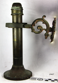 Flagstaff Hill Maritime Museum and Village
Lamp, Late 19th Century
... to become Sherwood-Linley at Nechells Park Works, Eliot Street...Flagstaff Hill Maritime Museum and Village 89 Merri Street ...Isaac Sherwoods Ltd were manufacturers of oil lamps and burners in Birmingham, in 1904 they were trading as Isaac Sherwood & Son Ltd. but by 1920 they had taken over Linley & Co. of 73-75 Great Lister Street, makers of `American' pattern lamps to become Sherwood-Linley at Nechells Park Works, Eliot Street. The company were a leading manufacturer of oil and candle lamps exporting their goods all over the world. The subject lamp is operated with a candle, which is inserted on the underside, it is sprung and as the candle burns the spring keeps the candle pushed upwards keeping the flame burning until the candle is extinct. Sherwoods invented and patented this innovation for candle lamps.The subject item is incomplete however it has some significance as it was designed to be used in a sea going vessel, as a result is quite rare also the item is made by a well known manufacturer.Spring loaded candle Lamp, brass, with gimbal wall attachment for use on a ship, shade and mount missing. Candle-stop has the words "Sherwoods Limited, trademark sound".flagstaff hill, warrnambool, shipwrecked-coast, flagstaff-hill, flagstaff-hill-maritime-museum, maritime-museum, shipwreck-coast, flagstaff-hill-maritime-village, candle lamp, gimbal spring, sherwoods limited -
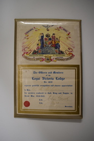 Warrnambool and District Historical Society Inc.
Certificate, Loyal Victoria Lodge, mid 1940s
... the Friendly Societies Park in Koroit Street. The MUIOOF joined... Street (south of Merri St) Warrnambool great-ocean-road The Loyal ...The Loyal Victoria Lodge was established in Warrnambool in1862. It was a Lodge connected with the Friendly Society Manchester Unity Independent Order of Oddfellows. Friendly Societies were established to give members assistance in times of illness and hardship and to offer insurance against such events. The MUIOOF had its origins in Manchester, England. The Warrnambool Lodge built the Oddfellows Hall in Koroit Street in 1869 and in 1872 it joined with other friendly societies and established the Friendly Societies Park in Koroit Street. The MUIOOF joined with the Australian Natives Association and today the new name in Australian Unity. No details are available on W. A. McLean but the certificate indicates that he served his country during World War Two.This certificate is of considerable interest as the Loyal Victoria Lodge was a pioneer friendly society in Warrnambool with its history going back to 1862. It is also a good example of the certificates given to Warrnambool residents who had rendered significant war time service in World War Two.Framed Certificate featuring text and a coloured picture. The picture includes: a dove, five scrolls, a laurel wreath surrounding a globe, three women in long dresses, three young children, two stylised flower beds, rays of light, a hill and four coats of arms. It is covered with clear plastic with a metal back and metal prop. WARRNAMBOOL DISTRICT INDEPENDENT ORDER OF ODDFELLOWS IN VICTORIA MANCHESTER UNITY FRIENDLY SOCIETY. The Officers and Members of the Loyal Victoria Lodge No. 4835 express grateful recognition and sincere appreciation to Bro. W. A. McLean for services rendered to God, King and Empire in Great War, 1939- 1945. N.G.Chas Gerock V.G. F.J. Toogood Rob Fairbridge Secretary. a circular red seal. -
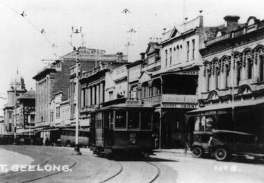
 Ballarat Tramway Museum
Photograph - Geelong 17 - Moorabool St, early 1930s
... Streets, is looking south along Moorabool St. Shows Geelong tram... four buses parked on both streets. In the background ...The photo taken at the corner of Moorabool and Malop Streets, is looking south along Moorabool St. Shows Geelong tram 17 tram about to turn "wrong line" from Moorabool St into Malop St. The tram has the destination of West. Why it is turning at this location is unknown. In the background is another tram running south along Moorabool St along with other trams at the intersection with Ryrie St. The photo shows four buses parked on both streets. In the background are the Solomons store, and the National Bank of Australasia buildings. Has many parked cars. The photo is pre 1934, before the construction of the T&G building at the corner of Moorabool and Ryrie Sts.Yields information about Geelong late 1930s and tramway operations.Black and white photograph - plain back.geelong, tram 17, moorabool st, malop st, tramways -
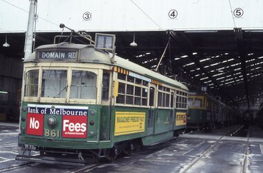 Melbourne Tram Museum
Album - Robert Thomson Slide Collection, "Melbourne 1-10th October 1993"
... RT019 Park Street - tram 844 - "West Preston" - route 10 RT020... RT019 Park Street - tram 844 - "West Preston" - route 10 RT020 ...Photo - see pdf file for further information. Number Brief Description RT001 South Melbourne depot - tram 861 -"Domain Rd" RT002 Fitzroy St, St Kilda - tram 858 - route 16 RT003 "3" - Z class - tram 210 - "City" - route 05 RT004 Swanston St - tram 989 - "University" - route 8 RT005 Swanston St - tram 992 - "City" - route 6 RT006 Swanston St - tram 867 - "City" - route 8 RT007 "2" - Track Relay Wattletree Road RT008 "1" Track Relay Wattletree Road - tram 214 - route 05 RT009 Swanston St - tram 26 - "City - Swanston St" - route 6 RT010 Balaclava Junction - tram 76 - route 09 RT011 "6" - Track Relay Wattletree Road RT012 Fitzroy St - tram 2042 - "East Brunswick" route 96 RT013 Swanston St - tram 985 - "City" - route 8 RT014 "4" - Track Relay Wattletree Road, Malvern East, looking east to terminus at Burke Rd RT015 "5" - Track Relay Wattletree Road RT016 Collins St - tram 923 - "St Kilda Beach" - route 12 RT017 Victoria Pde Siding - tram 67 - "Special" - route 12 RT018 Nth Fitzroy Depot - trams 2037 & 2021 RT019 Park Street - tram 844 - "West Preston" - route 10 RT020 South Melb Beach Ter - tram 49 RT021 St Kilda Line - tram 67 - "East Brunswick" - route 96 RT022 Port Melb Terminus - tram 67 - "Port Melb'ne" - route 111 RT023 Port Melb Line - tram 2038 - "Exhibition Bldg" - route 111 RT024 Sth Melb Depot - tram 937 – “Restaurant" RT025 Collins St - tram 282 - "City" - route 42 RT026 Spring Street - tram 2100 - "City Spencer St" - route 86 RT027 Spring Street - tram 2093 - "Port Melbourne" - route 111 RT028 "1" New Track Spring St RT029 "2" track construction - Spring St RT030 "3" track construction - Spring St RT031 "4" track construction - Spring St RT032 "5" track construction - Spring St Demonstrates the work of Robert Thomson in photography, collection and/or production of slidesAssembled album in a black presentation folder of 32 colour slides, collected or produced by Robert Thomson. All photographs have been scanned and placed on the Museum's G drive. A list of all photographs with details has been compiled. melbourne, tramways, trams, track construction -
 Kew Historical Society Inc
Photograph - Studley Park, 1937
... by the Yarra River, Studley Park Road, Princess Street and Fellows... by the Yarra River, Studley Park Road, Princess Street and Fellows ...Those sections of Studley Park closest to the River Yarra were set aside as parkland in the 1850s. After initial discussions about whether it was a suitable site for a Government House, much of the land was instead gazetted in the 1860s as the location for a new lunatic asylum, to expand overcrowded mental health facilities at the Yarra Bend Asylum on the other side of the river at Fairfield. Those sections of Studley Park bounded by the Yarra River, Studley Park Road, Princess Street and Fellows Street were subdivided and sold at the Crown Land Sales in 1851. Much of this urban area remained open farmland until the twentieth century, apart from mansions, largely located along the main roads.Original, black and white positive print of what is said to represent Studley Park in 1937. If the attribution and date is literally to be understood, then it would appear that the photograph may have been taken from the Kew side of the river looking across to open farmland in the Yarra Bend Park. If the designation of Studley Park is to be understood more loosely, then it might be a view of what is now East Kew, taken from a section of Kilby Road. Inscribed verso: "Studley Park 1937" studley park -- kew (vic.) -
 Kew Historical Society Inc
Work on paper - Sepia Wash & Ink, G B Richardson, Creek and Old Watering Stage, on the Yarra, East Collingwood, 1854, 1854
... Park Road (Johnston Street) Bridge in 1858 made its continued... Park Road (Johnston Street) Bridge in 1858 made its continued ...Blind Creek was located between the Abbotsford Convent and what is now the Collins Bridge in Studley Park. In an 1858 map of East Collingwood by Clement Hodgkinson, in the State Library of Victoria, one can see how the creek was originally a significant landmark in Collingwood; remaining vacant land until a barrel drain enclosed it. The area was later filled in, surveyed and developed. The position where Blind Creek entered the Yarra was in the immediate vicinity of Hodgson’s Punt, which had linked Kew to the other side of the Yarra from 1839. The Punt was purchased by the Colonial Government in 1852 and was in use until the opening of the Studley Park Road (Johnston Street) Bridge in 1858 made its continued use redundantThe point of view selected by the artist for the watercolour is from the banks of Blind Creek in East Collingwood, looking across the Yarra to the Kew side of the river.Inscribed verso 'Creek and Old Watering stage, on the Yarra East Collingwood 1854 / Trees, stage, &c have long since disappeared / [Artist Signature] / FT 110 / Creek itself now being filled in 1903.gb richardson, blind creek - abbotsford, yarra river - abbotsford (vic) - kew (vic), colonial artists, australian art - 19th century, george bouchier richardson -
 Ballarat Heritage Services
Photograph - Photograph - Colour, Clare Gervasoni, Carisbrook Police Lockup, c1998, c1998
... at a cost of 380 pounds. Standing in the park beside Bucknall... of 380 pounds. Standing in the park beside Bucknall Street ...The Logs at Carisbrook was the major gaol in the extensive Carisbrook Police District until 1858, and remained Carisbrook's gaol for low key offenders until about 1900. The lockup was registered by the National Trust on 22/10/1964.Colour photograph of the Carisbrook Police Lockup The Police staton was originally known as the Loddon Punt opening in 1851. The lock up was completed in October 1854 by James Corbet at a cost of 380 pounds. Standing in the park beside Bucknall Street it is the town's one significant historic building. It was originally built on the police paddock adjacent to the primary school and moved to its present site in 1886. The walls are made of interlocking horizontally-laid logs. The shingle roof has been replaced with corrugated iron. The lockup was built on site from local materials, and opened in 1851. It was moved to its current position ofter the original locationn flooded. The police station was closed in 1941. carisbrook, carisbrook lockup, carisbrook police lockup, log cabin, police, police paddock, the logs -
 Eltham District Historical Society Inc
Photograph - Aerial Photograph, Landata, Eltham and Eltham East, Nov. 1931
... Centred over present-day Beard Street bewteen Park Road... melbourne Centred over present-day Beard Street bewteen Park Road ...Centred over present-day Beard Street bewteen Park Road and Main Road, Eltham East Historic Aerial Imagery Source: Landata.vic.gov.au Aerial Photo Details: Project No :1931 Project : MALDON PRISON Run : 20 Frame : 3135 Date : 11/1931 Film Type : B/W Camera : F8 Flying Height : 11000 Scale : 18860 Film Number : 60 GDA2020 : 37°42'16"S, 145°09'41"E MGA2020 : 337912, 5825386 (55) Melways : 22 B2 (ed. 42)aerial photo, eltham, neil webster collection, beard street, eltham east, main road, park road -
 Ballarat Tramway Museum
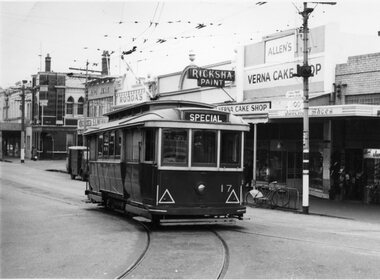
Photograph - Black & White Photograph/s, State Electricity Commission of Victoria (SECV), late 1950's or early 1960
... , intersection of Bridge and Main Streets Ballarat. Parked just past... and Main Streets Ballarat. Parked just past the junction points ...Yields information Bridge Street and the buildings at the junction with Main and Victoria St / Stones corner. Tram parked for some particular reason - see 3807.1 to .3 for a similar set of photographs. Shows shops and cars.Black and White photograph, No. 17 at Stone Corner, intersection of Bridge and Main Streets Ballarat. Parked just past the junction points - reason unknown, see also Reg Item 3803, 3807.1 to 3807.3 - for other photographs of the tram at the same location. Photo late 1950's or early 1960. Also has a number of interesting motor vehicles in the background. In the background a Ricksha Paints (pronounced Rickshaw), Allen's Vernal Cake Shop, Junction Shoes. Roddas, ANZ and the English Scottish Bank of Australia buildings in the view. tramways, trams, bridge st, stones corner, tram 17 -
 Melbourne Tram Museum
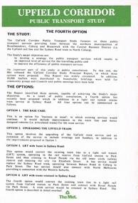
Pamphlet, The Met, "Upfield Corridor Public Transport Study", early 1989
... services in Sydney Road between Bell Street and Park St during... services in Sydney Road between Bell Street and Park St during ...Pamphlet - two A4 sheets - may not have been issued at the same time, titled "Upfield Corridor Public Transport Study", looking at a fourth option for the Upfield line. Lists the four options and gives details of the 4th option - retaining a tram services in Sydney Road between Bell Street and Park St during business hours. Notes the consultative period has been extended to June 1989, gives advice that Ove Arup Transportation Planning has been recently appointed, prior appoints and contact details.trams, tramways, upfield light rail, sydney rd, north coburg, conversion -
 Eltham District Historical Society Inc
Postcard - Photograph postcard, Boxing Day, Eltham, 26 Dec 1912
... College carpark in the Inez Avenue Park region with Diamond Street... College carpark in the Inez Avenue Park region with Diamond Street ...Postcard inscribed on reverse "Eltham 26.12.12" In the distance on the hill to the left of centre is the new St Mary's Catholic Church, corner of Main Road and Henry Street, Eltham (blessed 13 October 1912, later destroyed by fire in 1961). Just below the church, Shillinglaw Cottage is visible with two of the Shillinglaw trees partially obscuring the church. Photograph believed to have been taken just west of the present-day Catholic Ladies College carpark in the Inez Avenue Park region with Diamond Street running up hill behind the fence in middle of picture.Digital file only Postcards scanned from the collection of Michael Aitken on loan to EDHS, 13 Feb 2018michael aitken collection, postcards, eltham, picnic, catholic church, exhibition yprl 2019-12, shillinglaw cottage, shillinglaw trees, summer -
 Bendigo Historical Society Inc.
Photograph - S.E.C. VICTORIA, 1939
... colour utility vehicle parked in williamson street, twin power... of tree, dark colour utility vehicle parked in williamson street ...Photograph - black and white. The new SEC building still under construction. The 'old market building' can be seen to the left of the photo. Man on bicycle in dark clothing, man in black clothing walking to the right, lady in dark clothing walking to the left, light post with three cross bars and street light, advertising material displayed on corner section of fence, man in black standing over bhis bicycle to right of tree, dark colour utility vehicle parked in williamson street, twin power poles connected with 5 or six cross bars, vehicle angle parked in front of utility. Rear of photo has stamped name of the developer of the photo printed by Oliver's Bendigo. Number 79 witten in pencil.Printed by Olivers, Bendigo.organization, public utility, electricity company, s.e.c. victoria. 1939. bendigo. -
 Linton and District Historical Society Inc
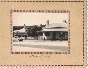
Card/Photograph, Christmas greeting card : A View at Linton, 1941, 1941
... or 1950s Holden?) is parked in Sussex Street outside the bank... South Wales. A car (1940s or 1950s Holden?) is parked in Sussex ...Sent as a Christmas card by T. & G. Thornton in 1941.A very small photograph which has been made into a plain, beige-coloured card with cut decorative edge and printed borders around edge of card and edge of photograph. The photograph shows Linton Post Office and Bank of New South Wales. A car (1940s or 1950s Holden?) is parked in Sussex Street outside the bank building. The words "A View at Linton" are printed on the front of the card underneath the photograph. A paper insert in the card has printed on one half: "May all the joys of an old-time Christmas be yours, and may the New Year be a happy one". Part of the other half of the paper insert has been cut away, but on the part that remains is the inscription: "from Tom & G. Thornton / Xmas 1941".On paper insert: "From Tom and G Thornton-Xmas 1941".tom thornton, g. thornton, linton post office, bank of new south wales linton, greeting cards, christmas cards -
 Ballarat Tramway Museum
Photograph - Black & White Photograph/s, State Electricity Commission of Victoria (SECV), late 1950's or early 1960
... , intersection of Bridge and Main Streets Ballarat. Parked just past... of Bridge and Main Streets Ballarat. Parked just past the junction ...Yields information Bridge Street and the buildings at the junction with Main and Victoria St / Stones corner. Tram parked for some particular reason - see 3807.1 to .3 for a similar set of photographs. Shows shops and cars.Black and White photograph, No. 17 at Stone Corner, intersection of Bridge and Main Streets Ballarat. Parked just past the junction points - reason unknown, see also Reg Item 3802, 3807.1 to 3807.3 - for other photographs of the tram at the same location. Photo late 1950's or early 1960. In the background a Ricksha Paints (pronounced Rickshaw), Allen's Verna Cake Shop, Junction Shoes. Roddas, ANZ and the English Scottish Bank of Australia buildings in the view. Also the signal for incoming trams from Main St, on the post with the tram stop. tramways, trams, bridge st, signals, stones corner, tram 17 -
 Ballarat Tramway Museum
Photograph - Black & White Photograph/s - set of 2, late 1920's, early 1930's
... of soft top cars parked in the street. Photo probably from... parked in the street. Photo probably from a postcard, has ...Yields information about the appearance of Geelong's Birney trams during the 1940's.Black and White Photograph of Geelong No. 10, Malop St, travelling north west to the railway station, during the late 1920s, between Gheringhap and Moorabool St. Tram has the destination of "Station", with the National Mutual, Moran's Hotel Orient in the background. Melbourne Bitter advertisement on the hotel. A number of soft top cars parked in the street. Photo probably from a postcard, has the words "T. Geelong. No. 8" along part of the bottom edge. Photo from the Peter Duckett Collection. For a close up of the tram itself see Reg Item 5822. 4335.1 - Black and White print contained within the Wal Jack Bendigo and Geelong Album, see Reg Item 5003 for more details. Added 7/8/2013. This item is the larger image of the two.On rear, stamped in black ink "Photo supplied from P.W. Duckett Collection, All Rights Reserved, 69 Howitt Rd. Nth Caulfield 3161." In hand writing on the rear "47)" in top left hand corner. In the body of the photograph "Malop St travelling NW to Station, between Gheringhap and Moorabool Sts." 4335.1 - in ink on rear. "Geelong No. 10 Original Condition, photo about 1930" and "Please Return"trams, tramways, geelong, malop st, mesco, tram 10 -
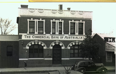 Bacchus Marsh & District Historical Society
Photograph, Commercial Bank of Australia Main Street Bacchus Marsh
... Dodge) is parked on the street. A lone girl stands... Moorish architecture. A car (possibly a 1937 Dodge) is parked ...The Commercial Bank of Australia building was constructed by J. F. Taylor in 1907 and shortly after commenced operations as a bank. The building was in use as a CBA bank until 1976 when it was demolished and a new building erected. The CBA continued its operations at this location; subsequently, various banks, such as the Bank of Melbourne and Westpac operated there. Part of the new building is now in use as a newsagency. The original architectural plans for this building designed by Walter Butler are held by the State Library of Victoria and can be viewed online through the Library's website: Citation: Butler, W. R., & Taylor, J. F. (1906). Design for banking premises at Bacchus Marsh for the Commercial Bank of Australia Ltd. URL: http://handle.slv.vic.gov.au/10381/473561 Black and white photographic print. Photograph of the Commercial Bank 138 Main Street Bacchus Marsh. On the left is a smaller brick building adjoining the bank. On the right there is a partial shot of a shop called The House of Hodgson. The bank building itself is shown as a substantial two-story brick building, the top storey appearing to be a dwelling with three ornamented windows furnished with curtains and blinds. The storeys are divided by a white panel bearing the words "The Commercial Bank of Australia Ltd". The lower storey has a central entrance with a panelled door. The door is flanked by two windows with reinforced lattices. The windows and door are surmounted by decorative arches reminiscent of Spanish Moorish architecture. A car (possibly a 1937 Dodge) is parked on the street. A lone girl stands on the footpath waving at the photographer.On the back: In pencil: 1937 Dodge?shops bacchus marsh vic., main street bacchus marsh vic., banks bacchus marsh vic., commercial bank of australia bacchus marsh -
 Eltham District Historical Society Inc
Photograph - Aerial Photograph, Landata, Montmorency, Feb. 1956
... and Eltham Lower Park to south, Bible Street to east and Para Road... and Eltham Lower Park to south, Bible Street to east and Para Road ...Centred on present day Grand Boulevard and Olympic Way, Montmorency bounded by Diamond Street to north, Old Eltham Road and Eltham Lower Park to south, Bible Street to east and Para Road to west. Historic Aerial Imagery Source: Landata.vic.gov.au Aerial Photo Details: Project No :250 Project : MELBOURNE OUTER SUBURBS PROJECT Run : 17 Frame : 115 Date : 02/1956 Film Type : B/W Camera : EAG9 Flying Height : 10000 Scale : 12000 Film Number : 1176 GDA2020 : 37°43'24"S, 145°07'55"E MGA2020 : 335375, 5823236 (55) Melways : 21 F7 (ed. 42)aerial photo, 1956-02, neil webster collection, eltham, main road, montmorency, bible street, diamond street, eltham lower park, grand boulevard, melway 21f7, old eltham road, olympic way, para road -
 Eltham District Historical Society Inc
Photograph - Aerial Photograph, Landata, Eltham, Vic, Apr. 1963
... Centred on present day Eltham Lower Park bounded... melbourne Centred on present day Eltham Lower Park bounded ...Centred on present day Eltham Lower Park bounded by Brougham Street to north, Yarra River and Fitzsimons Lane Bridge to south, Main Road at Kent Hughes Road to east and Bolton Street to west. Historic Aerial Imagery Source: Landata.vic.gov.au Aerial Photo Details: Project No :486 Project : MELBOURNE (1963) PROJECT Run : 7 Frame : 232 Date : 04/1963 Film Type : B/W Camera : RC8 Flying Height : 5100 Scale : 9600 Film Number : 1805 GDA2020 : 37°44'03"S, 145°08'33"E MGA2020 : 336329, 5822040 (55) Melways : 21 H10 (ed. 42)aerial photo, neil webster collection, 1963-04, bolton steet, brougham steet, eltham, eltham lower park, fitzsimons lane bridge, kent hughes road, melway 21h10, yarra river -
Vision Australia
Administrative record - Text, Quarterly general meeting of the Queensland Society of Blind Citizens: 19/11/1974 - 17/8/1976, 1974-1976
... Armstrong Street, Hermit Park was approved for purchase on 29/6/1976.... Armstrong Street, Hermit Park was approved for purchase on 29/6/1976 ...Minutes of the Queensland Society of Blind Citizens committee including centre activities, staffing changes, fund raising appointment and resignation of committee members and life governorships. Some highlights include: 19/11/1974 - the final meeting of the Queensland Musical, Literary and Self Aid Society for the Blind, dissolving it and vesting all assets to the Queensland Society of Blind Citizens. 21/11/1975 - a report of duplicity from a man who gave a false name and identification, then sold cash and property before absconding. 2/6/1976 - members in Townsville are desirous of purchasing a property to utilise as a headquarters. 41 Armstrong Street, Hermit Park was approved for purchase on 29/6/1976.1 bookqueensland society of blind citizens, queensland musical literary and self aid society for the blind -
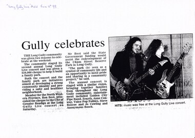 Bendigo Historical Society Inc.
Document - LONG GULLY HISTORY GROUP COLLECTION: GULLY CELEBRATES 5 JUNE 99
... the redevelopment of the Chum Street Reserve Park in Long Gully... of the Chum Street Reserve Park in Long Gully. Entertainment included ...Copy of a newspaper article titled Gully celebrates. The community staged its second annual Long Gully Live concert and was given a $20,00o cheque to help it building family park. Member for the North Western Province, Ron Best, presented the cheque to the City of Greater Bendigo at the Long Gully Live concert. He said the State Government funding would assist the redevelopment of the Chum Street Reserve Park in Long Gully. Entertainment included Golden City Pipe band, Zenyth, Anne Conway, Voice Pop Foibles, Steve Roscoe and Anonymous Bosch. Article includes a photo of two guitarists.bendigo, history, long gully history group, the long gully history group - gully celebrates, long gully live concert, ron best, city of greater bendigo, chum street reserve, golden city pipe band, zenyth, anne conway, voice pop foibles, steve roscoe, jo cowling, anonymous bosch -
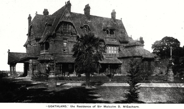 Kew Historical Society Inc
Photograph, 'Goathland', The Residence of Sir Malcolm D McEacharn, 1901-1911
... . The mansion had frontages to Studley Park Road and Stevenson Street... Park Road and Stevenson Street, including gardens laid out ...The architect, Edward Kilburn designed Byram in the Arts & Crafts style for the industrialist George Ramsden. Construction began in 1888 and was reputed to have lasted three years. The mansion had frontages to Studley Park Road and Stevenson Street, including gardens laid out with great taste, including pleasure grounds, tennis lawn, fruit and flower garden, and paddock.The size of many of the trees in the garden indicate that many survived from the garden of Clifton Villa, the previous single-storeyed house built on the site by the Stevenson brothers. Byram had views to Melbourne and Port Phillip Bay. The house was demolished in 1960, despite opposition from the National Trust (Victoria), and its gardens subdivided into residential allotments.An early photograph of Goathland (also known as Byram, Lowan and Tara Hall). The photo shows the front of the building during the period of Sir Malcolm McEacharn’s occupation of the house (1901-11). Edward George Kilburn, of Ellerker & Kilburn, had originally designed the house for the industrialist George Ramsden in 1888. When Sir Malcolm McEacharn purchased Byram, he was to rename it as Goathland. This has led to some confusion, as Goathland was also the name used for McEacharn’s other home in St. Kilda. The period of McEacharn’s ownership represented the high point of the mansion’s history. 'Lost Glories: a memorial to forgotten Australian buildings' was published by David Latta in 1986. It tells the story of a number of significant Australian buildings that had previously been demolished. A chapter in the book was devoted to Goathland, later known as Tara Hall. To supplement the text, he sourced photographs from a range of suppliers, chiefly the Royal Women's Hospital which had once owned Tara Hall, but had sold it in 1960. This is one of the photographs donated to KHS by the author."'Goathland', The Residence of Sir Malcolm D McEacharn"byram, goathland, tara hall, lowan, studley park road -- kew (vic.), melbourne mansions, e g kilburn - architect -
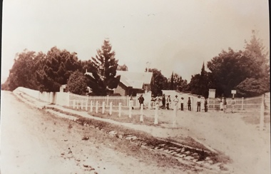 Kew Historical Society Inc
Photograph - Entrance to Boroondara General Cemetery
... an unusual triangular reserve bounded by High Street, Park Hill Road... triangular reserve bounded by High Street, Park Hill Road ...Boroondara Cemetery, established in 1858, is within an unusual triangular reserve bounded by High Street, Park Hill Road and Victoria Park, Kew. The caretaker's lodge and administrative office (1860 designed by Charles Vickers, additions, 1866-1899 by Albert Purchas) form a picturesque two-storey brick structure with a slate roof and clock tower. A rotunda or shelter (1890, Albert Purchas) is located in the centre of the cemetery: this has an octagonal hipped roof with fish scale slates and a decorative brick base with a tessellated floor and timber seating. The cemetery is surrounded by a 2.7 metre high ornamental red brick wall (1895-96, Albert Purchas) with some sections of vertical iron palisades between brick pillars. Albert Purchas was a prominent Melbourne architect who was the Secretary of the Melbourne General Cemetery from 1852 to 1907 and Chairman of the Boroondara Cemetery Board of Trustees from 1867 to 1909. He made a significant contribution to the design of the Boroondara Cemetery. (Source: Heritage Victoria)This photograph is one of the earliest known photographs of the cemetery, showing the early plantings and fences.Later print copy of an undated original photographic positive of the entrance to the Boroondara General (Kew) Cemetery. The Cemetery had been opened in 1855. This view is from Bulleen Road (now High Street) showing a group of 12 or 13 men standing in a line outside the entrance. At this time, the clocktower and high brick fence had not been constructed, but the trees have reached a substantial heightPencil inscription on reverse - "Boroondara Cemetery Entrance 1862"boroondara general (kew) cemetery, cemeteries -- melbourne (vic.) -
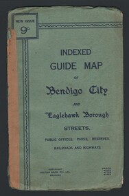 Bendigo Historical Society Inc.
Map - INDEXED GUIDE MAP OF BENDIGO CITY & EAGLEHAWK BOROUGH, Early to mid 1920's
... of Showgrounds between Park St, Baxter Street, Barnard St and Bridge Lane... between Park St, Baxter Street, Barnard St and Bridge Lane. Shows ...Map. Indexed Guide Map of Bendigo City & Eaglehawk Borough. Folded map contained within blue booklet. Booklet is light blue printed with dark blue ink. Copyright Bolton Bros. Pty. Ltd. Bendigo. Printed on front. Map shows the location of Sailors Gully, Peg Leg Gully, California Gully, Long Gully, Eaglehawk Creek, Bendigo Creek, Ironbark Creek. Shows location of Showgrounds between Park St, Baxter Street, Barnard St and Bridge Lane. Shows location of Golden Square Railway Station between Panton St and Allingham St. Shows what is now known as Creek St. Nth & Sth as Clark St Nth & Sth. Also shows Tramway Terminus along Carpenter St and Golden Square Tram Terminus on High St, Golden Square. Map has a street index and an index for Public Offices, Parks and Reserves.map, bendigo, township, indexed guide map of bendigo city and eaglehawk borough -
 Surrey Hills Historical Society Collection
Photograph, "Ancyra" 25 Weybridge Street, Surrey Hills
... on the corner of his property which extended from Weybridge Street.... This was located in the now-park in James Street. John Butler Maling Snr ...John Butler Maling, retired farmer, built his home on the corner of his property which extended from Weybridge Street to Whitehorse Road and from James to Ross Street. From 1853 he lived in a simple farmhouse located near the present Ross Street until he had 'Ancyra' built in c.1889 from bricks made from clay dug from a quarry on the property. This was located in the now-park in James Street. John Butler Maling Snr was born in Shepreth, Cambridgeshire. He married Kate Conlan in 1882 and they had 3 children - Silas, Alick and Zillah. He died in 1912 and is buried in Box Hill Cemetery. Often referred to as John Butler Maling Senior as he had a nephew by the same name. He also lived on a similar sized property known as 'The Willows', located to the west. He became the first Mayor of Camberwell. From c1936 til c1960 the property was used as a rest home (Ancyra Rest Home) and then a nursery (Pied Piper Nursery).This property is important as one of few remaining extant links to pre-urban Surrey Hills, and built from local material.A black and white photograph of a brick house with a slate roof and corrugated iron over the verandah and portico. A picket fence painted a dark colour features decorative finals on the tops of the posts.ancyra, house names, weybridge street, surrey hills, whitehorse road, james street, ross street, john butler maling (snr), mrs kate maling, silas maling, alick maling, zillah maling, miss kate conlan, box hill cemetery, ancyra rest home, pied piper nursery