Showing 389 items
matching water reserve
-
 Ballarat Tramway Museum
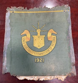
Functional object - Tramcar component - Panel ex Geelong tramcar No. 2 with SECV logo
The penel was recovered by the restorer of MESCo/SECV Geelong tram No. 2 and provided information about the paint scheme and layout. The Geelong tramway system closed in March 1956, No. 2 making its last run in January 1956. The body was subsequently sold to Phil Shoppee, a farmer at Murradoc on the Bellarine Peninsula. The farmer had used the tram body as a feed store, with this part placed up against a water tank or similar. This prevented it from being painted over. The panel shows the methodology of securing it to the tram body and the location of the lining and the emblem. The SECV logo or emblem dates from the formation of the SECV in 1921. The panel dates from the 1950s, possibly from a repaint after the side entry gates on the car were replaced by hinged doors in the mid-1950s. See reference.Yields information about the location of the lining and logo on the tram body and colours. One of the few original SECV logos formed from gold leaf in the Museum's collection.Sheet steel - treated - SEC green paint with a gold leaf SECV logo or emblemtrams, tramways, geelong, tram 2, secv tramways, logos, secv, emblems -
 Ballarat Tramway Museum
Document - Typed extract from SEC Magazine Feb-Apr 1951, State Electricity Commission of Victoria (SECV), "When Electricity and Trams came to Ballarat", 4/1951
The extract titled "When Electricity and Trams came to Ballarat" provides some stories of the early days of tramway operations, including the Sebastopol line and horse trams, a water chute at Lake Wendouee, crew wages, working conditions, windscreens. Written by A W WalkerYields stories about the early days of electric trams in Ballarat and horse trams to Sebastopol.Two sheets of paper, including a carbon copy of a typed extract from SEC Magazine Feb-Apr 1951 titled "When Electricity and Trams came to Ballarat"esco, trams, tramways, ballarat, crews, lake wendouree, windscreens, sebastopol, horse tram -
 Ballarat Tramway Museum
photograph - Black & White - Bendigo water car - track cleaner, Peter Duckett, c1947
Photograph of the Electric Supply Co. (ESCo) Bendigo water tram in front of the depot with two workmen. The tram has been modified with rail scrubbing blocks to clean the head of the rails. Photo by Peter Duckett about 1947.Yields information about the first Bendigo track cleanerPhotograph - Black & White - Bendigo water car - track cleaner - about 1947Details the image on the rear of the print in ink.bendigo, tramcars, esco, water tram, scrubber tram, bendigo tramways, depot -
 Ballarat Tramway Museum
Letter - from Peter Duckett to Wal Jack re Ballarat Sprinkler car tank, Peter Duckett, 8/3/1958
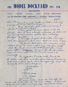
Wal Jack had an extensive range of correspondents throughout Australia and the world who often prepared extensive notes and records for him. This letter from Peter Duckett, the owner and proprietor of the Model Dockyard, dated 8/3/1955 discusses the water tank on the Ballarat ESCo sprinkler tram and its disposal history, First sold to a Mr Colters of Forest St and then sold to a lady in Invermay. Also compares the Ballarat tank to that of Bendigo. Finishes off with a discussion about his visit to Ballarat the previous weekend and the traffic on the road.Demonstrates some of the correspondence that Wal Jack received from around the world and that of Peter DuckettLetter on The Model Dockyard letterhead, printed quarto sheet, hand written by Peter Duckett dated 8/3/1955 - two sheets.letters, wal jack, peter duckett, sprinkler tram, water tanks, ballarat, bendigo, model dockyard -
 Ballarat Tramway Museum
Functional Object - Tramcar Internal Roof Ad, State Electricity Commission of Victoria (SECV), "Buy a BRIQUETTE hot water service", about 1960
Heavy cardboard sheet with printed sheet pasted to one side advertising Briquettes for Hot Water. "Pay less money for more hot water!" Buy a BRIQUETTE hot water service" with a tap in the bottom left hand corner, and steam on bottom edge - Birnie Briquette sign & hand holding two sixpences - 1959 or coins.secv, advertisements, briquettes -
 Ballarat Tramway Museum
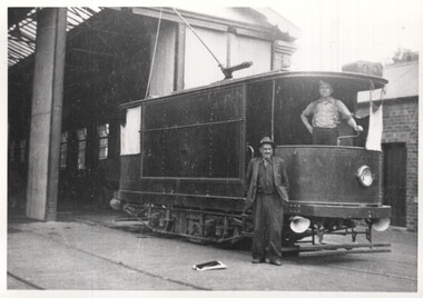
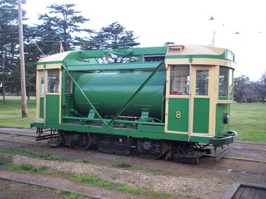
Functional Object - Tramcar, Melbourne and Metropolitan Tramways Board (MMTB), Scrubber Tram No. 8, 1934
One of a few service vehicles built from almost new by the MMTB rather than being a converted vehicle. Donated to the BTM in 1999 and has been an operational tram 2001.Single truck (4 wheels), special purpose tram fitted with two cabs, control equipment, air brakes, track scrubber or cleaning equipment, pump, water and air lines to clean track. Carries approx. 4 cubic metres of water. The tram was built by the Melbourne and Metropolitan Tramways Board in 1934 using the cabs from a C class tram (No. 32). It was transported to the isolated Footscray system a number of times to clean the rails there. In 1961 it received additional body bracing and repainted in the diagonal black and string (light cream) stripes. The tram became 8W during 1975 as the then new Z class trams came into service. By the early 1990's the need for the tram and the other similar cars used to "scrub" the surface of the rails was no longer. The tram was stored at Malvern depot for many years before being donated to the Ballarat Tramway Museum by the Public Transport Commission in September 1999. It has been scrubbing the rails in Ballarat since March 2001. For a detailed article see April 2008 issue of Fares Please. Photo Warren Doubleday 20/9/2008 after painting completed See Destination CityMMTBtrams, scrubber tram -
 Ballarat Tramway Museum
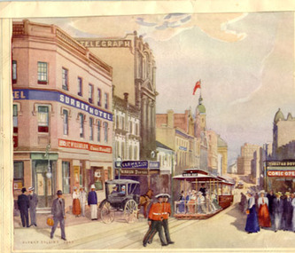
Drawing - Illustration/s, Albert Collins - Original artwork, King St. Sydney Cable trams
Colour print of a water colour by Albert Collins (1945) of a King St. Sydney with a Sydney cable tram set, titled "Another link with the past - King St. in the nineties", mounted onto textured card, lined on outer edges, with a piece of paper detailing the work attached to rear and an inscription.On rear "Compliments from Roy Field"trams, tramways, sydney, cable trams, king st -
 Ballarat Tramway Museum
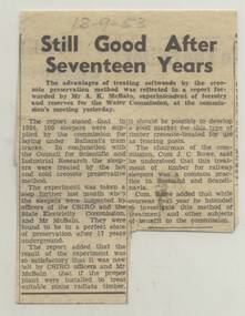
Newspaper, The Courier Ballarat, "Still good after Seventeen Years", 18/09/1953 12:00:00 AM
Yields information about a provision of treated wooden pine sleepers to tramways in Ballarat.Newspaper clipping from The Courier, Ballarat, dated 18-9-53 regarding treated softwood sleepers, 100 installed in 1936 from Ballarat Water Commission, creosote treatment CSIRO. Titled "Still good after Seventeen Years" Record updated and images added 20/8/2013.Pencil date of "18-9-53"trams, tramways, sleepers, tram track, trackwork -
 Ballarat Tramway Museum
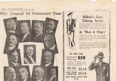
Newspaper, The Courier Ballarat, Courier, 8/3/1938 p21, 22, 29 & 30 - photo of Sturt St, Mar. 1938
Yields information about Ballarat and its locations or environs late 1938.Pages 21,22,29 and 30 of the Centenary issue of the Ballarat Courier, 8/3/1938. Page 21 "When the World was Wide", photos, Ballaarat City Council of Centenary of settlement in the Ballarat district, year, and Sturt St. from Bridge St., possibly original photo of time. Ads. - Marks & Phillips, - Tailors and C.J.Coles. Page 22 - Towns that have a history - Learmonth, Clunes, Creswick and Buninyong. Photos - Learmonth, Clunes and Forestry school Creswick. Ads - State Savings Bank of Vic, Swanston Used Cars. Page 29 - Ballarat's historic Sports Grounds - origin and development, Eastern Oval incident, listing of nuggets found and quartz specimens. Ads for Prestige stockings, T&G Mutual Life and Fosters Lager. Photo of mine at No. 6 shaft on Band of Hope and Albion Consolidated. Page 30 - articles - Ballarat's sporting origins and swamp to reservoir (water supply). Photos of First England Cricket team to visit Ballarat and aqueduct at Kirks storage basin. Ads for Craig Bros, Pratts cash stores, Haymes paints and Ballarat Block Arcade - shops. Record reviewed and images of some of the pages added 10-9-2013trams, tramways, ballarat centenary celebrations, centenary, sports ground, water supply -
 8th/13th Victorian Mounted Rifles Regimental Collection
Photograph
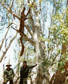
In 1988, as part of a Defence of Mainland Australian policy, defence of facilities of strategic importance in northern Australia were allocated to Army Reserve units. ‘A’ Squadron was allocated the defence of Tindal Air Force base located 15 KM outside Katherine in Northern Territory. Consequently the Squadron deployed on Exercise ‘Northern Explorer’ to gain first-hand knowledge of operating conditions for mounted and dismounted patrolling in the area.Colour photograph of Captain C. Carrington, earing hat, and Sergeant Koschel of ' A ' Squadron 8/13 VMR during Exercise " Northern Explorer." Flood debris caught high in tree branches indicate water level during wet season on Ferguson River, Northern Territory. -
 8th/13th Victorian Mounted Rifles Regimental Collection
Photograph
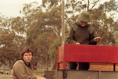
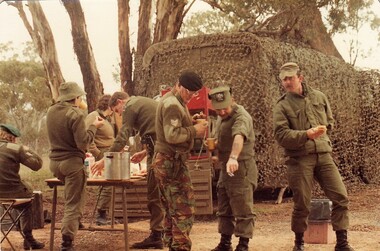
Members of the Women’s Royal Australian Army Corps (WRAAC) were posted to Army Reserve units in the 1980s and 1990s. They were rarely posted to Armoured Fighting Vehicles (AFVs) but were invaluable in the A1 Echelon driving fuel, ammunition, ration and water supply vehicles. Colour photograph of two WRAAC soldiers of 'A' Squadron 8/13 Victorian Mounted Rifles serving a meal from a BBQ set up on back of truck in A1 Echelon during field training. Private L. Cameron at left ; Private T. Roche, right. -
 8th/13th Victorian Mounted Rifles Regimental Collection
Photograph
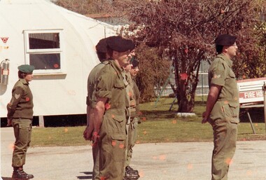
The 8th/13th Victorian Mounted Rifles was raised as a regiment of the Royal Australian Armoured Corps on 1 May 1948 with Headquarters in Melbourne and squadrons in Sale, Benalla/Wangaratta and Albury. In 1955 Regimental Headquarters moved to Wangaratta and a second squadron was located at Albury. The Sale squadron transferred to 4th/19th Prince of Wales’s Light Horse. In 1977 8/13 VMR Regiment was reduced to an independent squadron A Squadron 8th/13th Victorian Mounted Rifles and in 1991 was linked with 4th/19th Prince of Wales’s Light Horse forming the VMR Squadron of that regiment.Members of the Women’s Royal Australian Army Corps (WRAAC) were posted to Army Reserve units in the 1980s and 1990s. They were rarely posted to Armoured Fighting Vehicles (AFVs) but were invaluable in the A1 Echelon driving fuel, ammunition, ration and water supply vehicles. Colour photograph of soldiers of ' A ' squadron 8/13 Victorian Mounted Rifles on parade at Buna Barracks Albury 1986. Sergeant D. Reynolds ( WRAAC ) at left; Corporal B. Lewis at right. -
 8th/13th Victorian Mounted Rifles Regimental Collection
Photograph - Sandwich and tea
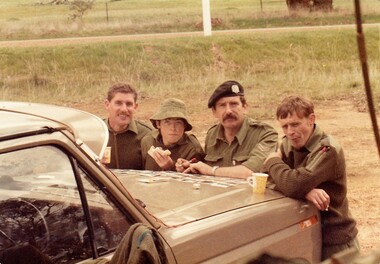
While many recruits could already drive when they joined 8/13 Victorian Mounted Rifles it took many hours of instruction and training before they were licenced to drive heavier, more complex army vehicles both on and off road and under combat conditions.Members of the Women’s Royal Australian Army Corps (WRAAC) were posted to Army Reserve units in the 1980s and 1990s. They were rarely posted to Armoured Fighting Vehicles (AFVs) but were invaluable in the A1 Echelon driving fuel, ammunition, ration and water supply vehicles. Shows citizen soldiers on weekend training.Colour photograph of 4 soldiers of ' A ' Squadron 8/13 Victorian Mounted Rifles at a road side break during a driving exercise, 1986. From left : Corporal M. Roberts, Private T. Roche, Corporal Tewson and Trooper Bowerman.military, citizen soldiers, vmr, uniform -
 8th/13th Victorian Mounted Rifles Regimental Collection
Photograph
While many recruits could already drive when they joined 8/13 Victorian Mounted Rifles it took many hours of instruction and training before they were licenced to drive heavier, more complex army vehicles both on and off road and under combat conditions. Members of the Women’s Royal Australian Army Corps (WRAAC) were posted to Army Reserve units in the 1980s and 1990s. They were rarely posted to Armoured Fighting Vehicles (AFVs) but were invaluable in the A1 Echelon driving fuel, ammunition, ration and water supply vehicles. Two colour photographs of group of soldiers of ' A ' Squadron 8/13 Victorian Mounted Rifles at a meal break during a driving exercise, 1986. Considerable variation in dress and headgear. Green beret at left, Sergeant D. Reynolds; hat Private T. Roche; Black beret Sergeant H. Wilson; no hat Corporal M. Roberts ; peak Cap with badge Warrant Officer 2 Burnie; Peak cap Corporal Potts. -
 Sunbury Family History and Heritage Society Inc.
Photograph, C1916
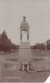
Joseph Starkie was the Chairman of the Sunbury Waterworks Trust from 1905 to 1913. During that time he was instrumental in getting a permanent water supply installed for the town of Sunbury. After his death in April 1913, the townspeople erected a memorial which stood at the intersection of Brook and Stawell Street. It was unveiled on 26 January 1915 by Terence O'Brien. The original memorial included a drinking fountain and horse trough. As traffic increased within the town, the centre section of the fountain, without the horse trough, was resited in a reserve opposite the Memorial Hall. The photograph shows the monument on its original site. The installation of a reliable and permanent water supply for Sunbury was an important achievement for the town in the early years of the twentieth century.A sepia photograph in post card format of a water fountain and trough in a street in front of an avenue of trees.J. D. STARKIE MEMORIALstarkie, joseph daniel., water fountain, j.d.starkie memorial -
 Sunbury Family History and Heritage Society Inc.
Photograph, c1900s
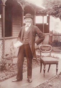
The man photograph in a garden is Joseph David Starkie, who was a Bulla Shire councillor for more than twenty years and during that time he was elected Shire President four times. He was also a member of the Sunbury Waterworks Trust and served as the chairman from 1905 - 1908. While serving on the water board he was instrumental in Sunbury gaining a permanent water supply. A drinking fountain has been erected on a reserve at the Village Green to honour the arrival of the permanent water supply to the town. The installation of a permanent water supply benefitted the town and contributed to a more reliable rail service as steam trains refilled their tanks with water at Sunbury Station. Prior to this the water was transported by horse and cart from nearby Jacksons Creek.A sepia photograph of a well-dressed man who is holding a book and is standing in a front garden of a weatherboard house.starkie, joseph daniel. -
 Surrey Hills Historical Society Collection
Photograph, Surrey Hills Reservoir No 1
Copied by Ken Hall from an early postcard. This is Surrey Hills Reservoir No 1 on the corner of Tower Street built in c1892 at a cost of £12,000 to supply higher sections of the area. The builders were Jack and Bob Laudehr, partners in a wood yard in St. Kilda (Vic). They began by delivering firewood but extended to contract work involving timber. Another of their projects was to lay cable tram tracks commencing in Acland Street St. Kilda and running along The Esplanade. The reservoir in Canterbury Road was a large concrete structure built before the introduction of reinforcements. The excavated material was banked against the sides and pine trees were planted in it to add strength to the embankment. They were paid £2,000 for their work. Construction of Surrey Hills Number 2 Reservoir was completed in 1913 and the accompanying tower was built in 1929. It is assumed that the Miss Hill as the source of the donation (via Bill Dempsey) was Ivy Annie Hill (1902-1984). She was the only female child of William Valentine Dempsey to not marry. Bill Dempsey's mother was Laura Constance 'Birdie' Hill (1900-1968) who married Albert Dempsey.A sepia photograph within a post card of a reservoir on Canterbury Road, Surrey Hills. In the background to the left you can see the top halves of two houses and the tops of some trees. The photo takes up only the central section of the postcard.Below the photo on the front of the postcard on blue biro "Reservor [sic] Canterbury Rd / Surrey Hills." On the rear in grey lead pencil in Jocelyn Hall's handwriting: "Donor W Dempsey ------------- Keep / (nephew) / [arrow pointing down] / From Miss Hill / 10 Pembroke St SH / This house can be / seen in front of / No 12 which has / tower"1890, water supply, mmbw, edward d dyer (mr), 10 pembroke street, 12 pembroke street, surrey hills, ivy annie hill (miss), william valentine hill (mr), canterbury road, tower street, water supply structures and establishments, dams and reservoirs, jack laudehr (mr), bob laudehr (mr) -
 Surrey Hills Historical Society Collection
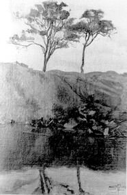
Photograph, Muriel Pornitz (deceased), Quarry on site of Grovedale Road - James Street Park
The photo is of a painting of the dam formed on land between Grovedale Road and James Street, Surrey Hills. It was painted in 1927 by Miss Muriel Pornitz, an art teacher, who lived in Grovedale Road. The land had been part of Mr James Maling Snr’s property and in the 1880s clay was removed to build houses, including his own located on the corner of Weybridge and James Streets. Maling grazed cattle on this area and used it as a dam. The land was subsequently made into parkland, the quarry / dam having been filled in after several drownings had occurred in the 1920s/1930s. See also SHP94, another copy of the same. Muriel Hedwig Lucy Pornitz lived at 22 Grovedale Road, Surrey Hills. She was born c1894 in Balwyn; died in Kew on 1 December 1982. She was the daughter of Konrad Pornitz (1864-1903) and his wife Charlotte Richardson Gooderidge (1863-1942), known as Tottie, who married in 1890. Konrad Pornitz is listed in the 1892 directory as living in Edgevale Road, Kew and the business Pornitz and Ross at 291 & 293 Little Collins Street, importers and commission merchants. The 1896 directory gives the Kew address as 176 Edgevale Road, Kew, however the business Pornitz and Ross was dissolved on 1st day of October 1892, by mutual agreement. Legal notice advised that: Mr Pornitz will hereafter carry on the business on his own behalf at the same address, under the style "Pornitz and Ross". Muriel is buried in Box Hill Cemetery (B-086-0042) along with Ulrich Horst Holm Pornitz known as Horst or Bon (d 1957) and Edith Olga Pornitz (d 1951), her brother and sister. A further sibling (Konrad b 1891) died in infancy. He is buried with his mother in Boroondara (Kew) Cemetery - C/E A 0366. Konrad died at his home 'Yarran' in Lane Cove Road, North Sydney on 31 October 1903; reported in the Sydney Morning Herald. Buried Gore Hill Cemetery, St Leonards, North Sydney. The headstone reveals he was born in Chemnitz, Saxony in 1863. Muriel was also known as Muriel Pornett. She studied at the South Australian School of Arts & Crafts in 1911 under James Ashton and Fred Britton, and at the Australian School of Etching in Sydney. She was also an illustrator and cartoonist. The photo, and the painting from which it is derived, documents the landscape prior to close settlement and is material to early building and farming in the Surrey Hills area.A black and white photograph of a painting of a landscape of parkland. Two trees are on top of a rise and are reflected at the bottom in water. The signature of the artist is in the bottom right corner: "AUST MP 192" (and the rest is cut off).(miss) muriel pornitz, grovedale road, james street, surrey hills, artists, parks and reserves, (mr) john butler maling, snr, quarry, dam, (miss) muriel hedwig lucy pornitz, box hill cemetery, muriel pornett -
 Surrey Hills Historical Society Collection
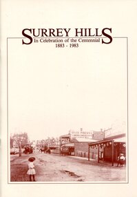
Book, Surrey Hills: in celebration of the centennial 1883-1983, 1983
A pictorial history of Surrey Hills based on information collected and based at the Surrey Hills Neighbourhood Centre. It includes early rural properties and diaries, the coming of the railway, land sub-division and early homes, schools, parks and recreation.A pictorial history of Surrey Hills based on information collected and based at the Surrey Hills Neighbourhood Centre. It includes early rural properties and diaries, the coming of the railway, land sub-division and early homes, schools, parks and recreation.surrey hills, railways, land use, migrants, spanish communities, transport, houses, wattle park, festivals and celebrations, churches, education, water supply, fire stations, hospitals, (mr) george klepper, ainger family, (mr) john woodhead, (mr) h. breedon, medical services, real estate agents, businesses, musical events and activities, entertainment, parks and reserves, scouts, guides -
 Surrey Hills Historical Society Collection
Book, Surrey Hills: in celebration of the centennial 1883-1983, Reprinted November 1992
A pictorial history of Surrey Hills and Mont Albert based on information collected by the history group at the Surrey Hills Neighbourhood Centre. It includes information about early rural properties and dairies, the coming of the railway, land sub-division and early homes, doctors, schools, churches, parks and recreation facilities.A pictorial history of Surrey Hills based on information collected and based at the Surrey Hills Neighbourhood Centre. It includes early rural properties and diaries, the coming of the railway, land sub-division and early homes, schools, parks and recreation.1992surrey hills, railways, land use, migrants, spanish communities, transport, houses, wattle park, festivals and celebrations, churches, education, water supply, fire stations, hospitals, (mr) george klepper, ainger family, (mr) john woodhead, (mr) h. breedon, medical services, real estate agents, businesses, musical events and activities, entertainment, parks and reserves, scouts, guides -
 National Wool Museum
Photograph - Portrait of Dr John Newman, Nicole Marie, 2021
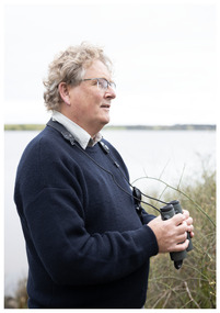
Thousands of volunteers work tirelessly to conserve and protect the environment of Geelong and the Bellarine. Their work often goes unnoticed. In 'The Work of Nature' the National Wool Museum and the Environment Department at the City of Greater Geelong worked with photographer Nicole Marie to showcase the significant contribution of environment volunteers in our region. Each of the eight people showcased in these portraits were nominated by their peers and members of the community for their significant contribution to conserving and protecting the environment. Dr John Newman - Geelong Field Naturalists Club Over almost twenty years John Newman has organised large groups of volunteers to conduct surveys across Geelong and the Bellarine for shorebirds and waterbirds. Understanding and collecting important environmental data helps in the effort to preserve important sites, much of this data is collected by volunteers. The information collected in Geelong and the Bellarine also forms part of national and international datasets that helps in understanding global patterns of migratory birds, such as sharp-tailed sandpiper, red-necked stint and the critically endangered curlew sandpiper. The data collected at the Moolap Saltworks (since 1981) and co-ordinated by John since 2003 highlighted the importance of this site for these three species and played a crucial role in protecting the area as a conservation site. Photo at Taits Point, Lake Connewarre Wildlife Reserve by Nicole Marie.Image showing an environmental portrait of a man holding binoculars with a water landscape in the background.environment, conservation, portraits, geelong, nature, exhibition, work of nature, geelong nature forum, volunteers, lake connewarre -
 Port Fairy Historical Society Museum and Archives
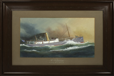
Decorative object - Painting, F. I. Endeavour
For many years this painting hung in the offices of the Belfast & Koroit Steam Navigation Company in Port Fairy. It was painted by Arthur Victor Gregory (1867-1957), a water colourist and marine artist. It depicts the Fisheries Investigation Ship Endeavour, a trawler built to the specifications of the Commonwealth Government in 1909 to assist in identifying new fishing grounds in the seas around Australia. The Endeavour was lost in December 1914 between Macquarie Island and Hobart with the loss of all twenty-one men on board, including Harald Dannevig, the Commonwealth Director of Fisheries.A Painting of a forgotten ship and crew that were forerunners of investigating the reserves of fish in our oceans.A painting of the F. I. Endeavour in a wooden frame. Scroll work on frame.Front - The F. I. Endeavour crossing Bass's Straits A. V. Gregory 10 Reverse - Regal Patronage ?.8.1854 Arthur V. Gregory Marine ? Arthur V. Gregoryship, fishing, scientific, belfast & koroit steam navigation company, endeavour, macquarie island, hobart, harald dannevig -
Friends of Ballarat Botanical Gardens History Group
Work on paper - Crown Land Reserves Improvement Program, Two Projects, C 2001
These documents provide detailed information about improvements to the Adam Lindsay Gordon Cottage and plans for the Removal of Wishing Well and New Water Feature and Path Re-Alignment which has not been completed.These documents give details on how improvements to the Adam Lindsay Gordon Cottage Area would enhance the site and planning for a new water feature and the major re-alignment of paths within the Gardens.3 sheets of paper. 1. entitled Crown Land Reserves Improvement Programme 2. Diagram listing the costings for the Adam Lindsay Gordon Cottage Area 3. Costings listed for the Removal of the Wishing Well and New Water Feature and Path Re-Alignment.p.1 question mark in black biro, end of 4th line. p.2 notes written in blue biro below the diagram are most relevant.john garner, doctor john garner, ballarat botanical gardens, friends of ballarat botanical gardens, crown land reserves improvement programme, adam lindsay gordon cottage area, the removal of the wishing well and installation of new water feature, costs, clips grants programme., gardens, ballarat, john garner collection -
Tarnagulla History Archive
Postcard - Photographic postcard: The Reservoir, Tarnagulla, c. 1900-1930
Williams Family Collection. Photographic postcard, front image depicting the water reservoir at Tarnagulla Recreation Reserve. tarnagulla -
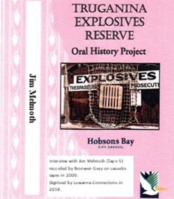 Truganina Explosives Reserve Preservation Society Inc (TERPS)
Digitised Oral History – Truganina Explosives Reserve - Tape 5 Jim Melmoth, 2018
The interviews were recorded in 2000 by Bronwen Gray and Alan Young for the production of Unreserved, Stories from Truganina Explosives Reserve, animated stories from past residents, workers and interested people of the Reserve (subject to copyright 2004). Edgar James (Jim) Melmoth began work at the Truganina Explosives Reserve at age 19 (1952) as part of the maintenance crew – painting, tram line maintenance, storm damage clearance. He helped build the pier extension and the water tower. In this interview he describes some incidents and some amusing stories of the clysdale horses. A primary source of information on memories of the Truganina Explosives Reserve and Altona,VictoriaDigital copy of original cassette recorded in 2000 and digitised in 2018hobsons bay city council, explosives, air raid shelters, altona pier, brown coal, camouflaged fences, world war two, gelignite, horse drawn wagons, clysdale horses, lighters, williamstown, upton street altona, water tower, adze, john gates, public works department, explosives pier, cherry lake, altona, altona meadows, lennie finley -
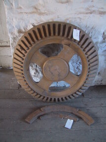
 Parks Victoria - Andersons Mill
Tool - Pattern, ring gear
Used to make cast for the metal ring gear for the water wheel which powered the Mill.Slightly arched wooden pattern with wooden ridges along the edge. Three square metal plates with a hole in the centre, bolted on with four bolts. Ten pentagin pieces of wood attached to the face. -
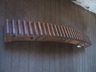
 Parks Victoria - Andersons Mill
Tool - Pattern, wooden
Used as pattern to cast crown wheel of drive on water wheel. Actual drive has since been sold, only mold remainsCircular wooden pattern, raised centre circular area surrounded by four wide, flat spokes at regular intervals (the interim spaces being cut out with rounded corners) which are in turn surrounded by a rim which tapers back from the centre of the piece and has fixed to it regularly interleaved slats. Slats of protruding oblongs tapered from attachment to top and also central end to outer point. Light coloured wood 1 & 2 are Broken off pieces of back. -
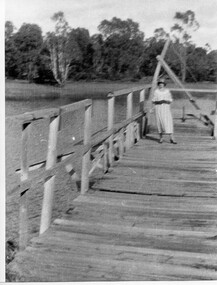 Tarnagulla History Archive
Photograph of a woman on the Reservoir jetty, Tarnagulla Recreation Reserve, Woman on the Reservoir jetty, Tarnagulla Recreation Reserve, circa 1930s (original image)
... . The woman may be a Comrie. tarnagulla recreation reserve reservoir ...Murray Comrie Collection. The woman may be a Comrie.Monochrome photograph depicting a woman on the Reservoir jetty at Tarnagulla Recreation Reserve. This dark, poor quality copy was made from an older original photograph, probably in the late 1960s. tarnagulla, recreation reserve, reservoir, res, jetty, water, people -
 City of Kingston
Photograph - Colour, Paul Tresize, 1998
The name Mordialloc was derived from the name Moody Yallock, which comes from the Bunurong language. The Bunurong Peoples are the Traditional Owners of this area. The name means “high water” or “high creek”. In 1839, colonial authorities declared the mouth of the creek, and an additional 830 odd acres as an Aboriginal Reserve, although this proclamation was never gazetted. The reserved land included part of the Carrum Carrum Swamp which was abundant with wild life and natural resources. Regular encroachments, including land sales which began in 1863, were made on the land until 1878 when the Reserve was declared closed, and the land was opened up to land sales. Market gardening and suburban house lots quickly began to develop, and Mordialloc became a renowned picnic and holiday site. Mordialloc Creek is a popular bay side destination for local and visitors, and is a site for boating, kayaking, fishing and swimming, along with many other activities.Colour photograph of Mordialloc Creek, looking out to the bay. Many small fishing and leisure craft are moored on either side of the banks of the creek. To the right hand side can be seen parklands, while the left hand side has a small inlet in which more small crafts are moored.mordialloc, bunurong, traditional owners, suburbs, boats, fishing, waterways -
 City of Kingston
Photograph - Colour, 1998
The name Mordialloc was derived from the name Moody Yallock, which comes from the Bunurong language. The Bunurong Peoples are the Traditional Owners of this area. The name means “high water” or “high creek”. In 1839, colonial authorities declared the mouth of the creek, and an additional 830 odd acres as an Aboriginal Reserve, although this proclamation was never gazetted. The reserved land included part of the Carrum Carrum Swamp which was abundant with wild life and natural resources. Regular encroachments, including land sales which began in 1863, were made on the land until 1878 when the Reserve was declared closed, and the land was opened up to land sales. Market gardening and suburban house lots quickly began to develop, and Mordialloc became a renowned picnic and holiday site. Mordialloc Creek is a popular bay side destination for local and visitors, and is a site for boating, kayaking, fishing and swimming, along with many other activities.Colour photograph of Mordialloc Creek, looking inland.Small fishing and leisure boats are moored on either side of creek, with a view of the Mordialloc Bridge Hotel in the background.mordialloc, bunurong, traditional owners, suburbs, boats, fishing, waterways, hotel