Showing 7072 items
matching snowy-river
-
 Greensborough Historical Society
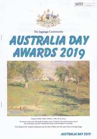
Booklet, Jenny Macklin, The Jagajaga Community Australia Day Awards 2019, 26/01/2019
This booklet lists the recipients of the Jagajaga Community Australia Day Awards 2019, hosted by Jenny Macklin, Federal Member for Jagajaga. GHS Committee Member Anne Paul received a Jagajaga Community Award for services as a volunteer with Greensborough Historical Society, Friends of the Plenty River and the Plenty River Forum. A supplementary page and colour photograph of Anne accompanies the booklet. Short report by Rosie Bray.20 p. booklet, with single page and col. photograph 2 copies`australia day awards, jagajaga, anne paul -
 Geelong RSL Sub Branch
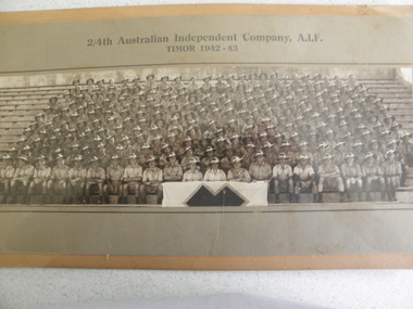
Photograph, 2/4th Independent Company, circa 1943
This photograph is of 2/4th Independent Company A.I.F Timor 1942-43.This Company was formed in December and posted to Katherine, NT, in March 1942. The Company was deployed to areas between McArthur and Ord Rivers and in August moved to Adelaide River. In September the Company moved to Darwin and boarded the destroyer HMAS Voyager and travelled to East Timor (then Portuguese Timor) to reinforce 2/2nd Independent Company.This photograph is the 2/4th Independent Company Members that served in East Timor 1942-43.A photograph attached to cardboard in a metal frame. The Photograph is covered by perspex instead of glass.2/4th Australian Independent Company, A.I.F. Timor 1942-43.east timor, a.i.f. 2/4th independent company. 1942-43. -
 Federation University Historical Collection
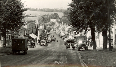
Postcards - black and white, Butt Bourton, Burford
Burford is a small town on the River Windrush in the Cotswold hills in west Oxfordshire, England, about 18 miles (29 km) west of Oxford, 22 miles (35 km) southeast of Cheltenham and only about 2 miles (3 km) from the Gloucestershire boundary. The toponym derives from the Old English words burh meaning fortified town or hilltown and ford, the crossing of a river. (Wikipedia)A streetscape photographic view of Burford, England showing buildings, cars and people. chatham family archive, burford -
 Robin Boyd Foundation
Document - Script, Robin Boyd, The Flying Dogtor. Episode 48 The Tower, 1963
The Flying Dogtor was called to the Snowy Mountains Scheme by the Government to help solve the mystery of a monster or sea serpent, that was wandering the lakes and tunnels. Several times, the Dogtor caught a glimpse of a monster but every time, it got away before he could see it properly or speak to it. Then he came to a weird-looking lookout on the edge of the lake, and paid his sixpence to climb to the platform for a look through a telescope. He heard faintly, a nasty sound of eerie, spidery laughter.The Flying Dogtor" series was broadcast on Australian Television Network (later becoming the Seven Network) between February and April 1964 (see item D254 for schedule).Typewritten, carbon copy, foolscap, 2 pagesHandwritten pencil edits and additions.the flying dogtor, robin boyd, crawford productions, manuscript -
 Orbost & District Historical Society
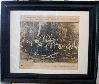
black and white photograph, late 19th century - early 20th century
The local logging industry had its beginning back in 1882. The first batch of timber was cut in a sawmill at Orbost on the Brodribb River.Orbost has historically been based on the timber industry, but that industry has declined considerably over the last 20 years. The number of locals involved in the timber industry has declined and many of the mills have closed. This item reflects a time when that industry was a significant contributor to the economy of the district.A very large framed black / white photograph of a large group of timber workers in a bush setting. Above and below the photograph are their names. The names can be clearly read. The photograph is on a white buff card under glass in a black frame.Names are type - written above and below the photograph.timber-industry -
 Orbost & District Historical Society
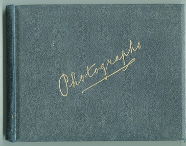
photograph album, James, Harry, 1900 - 1910
Photographs in this album are : forest,creek; Burns Cutting; river with bridge; Tony in his boat (spare print); Murrungowar and three of Conran.Henry James (1860-1932) was a well-known identity in the Orbost district.He was a stock agent and auctioneer who helped to establish the seed bean industry in Orbost. He was the second secretary of the Snowy River Shipping Co. as well as a shire councillor and prominent member of MUIOOF.a fabric covered book with gold print - "Photographs" on front cover. It contains an assortment of photographs.inside front cover - "Photographs taken by Mr Harry James about 1900-10"james-harry photography-orbost-conran-murrungowar -
 Greensborough Historical Society
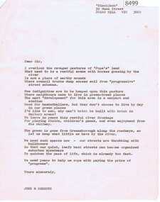
Letter - Poem, June Roberts, Poem by June Roberts, 1960c
Freeform poem protesting loss of amenity of river frontage land in Greensborough, for inclusion in Greenhills Progress Association newsletter, by June Roberts1 p. typed letter, by June M. Robertspoulter reserve greensborough, pope place greensborough, june roberts -
 Greensborough Historical Society
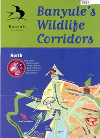
Poster, Banyule City Council, Banyule's wildlife corridors, 2000c
This poster shows the habitat and wildlife corridors within the City of Banyule, including the Darebin Creek catchment and Plenty and Yarra river catchments.Colour poster, folded, printed on bot sides.native fauna, wildlife corridors, wildlife habitat -
 Greensborough Historical Society
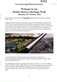
Booklet, Greensborough Historical Society, Poulter Reserve Heritage Walk, 29/10/2022
The Poulter Reserve precinct is bordered by the railway line, Main Street and the Plenty River. This booklet accompanies a guided walk around the area.20 p., text and color and black and white images.poulter reserve greensborough, main street greensborough, plenty river greensborough -
 Greensborough Historical Society
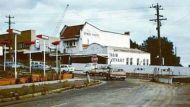
Photograph - Photograph - Digital Image, Main Street bridge Greensborough 1970s, 1970s
A colour photograph of the corner of Para Road and Main Street Greensborough in the 1970s, during the duplication and construction of the bridge over the Plenty River.Digital copy of colour photograph.main street greensborough, para road greensborough, plenty river bridge -
 Mission to Seafarers Victoria
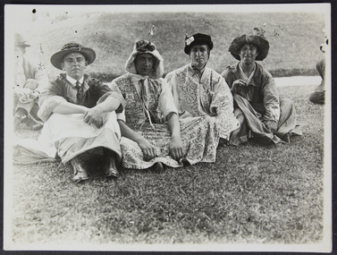
Photograph - Photograph, Black and white, Fancy Dress Race - Boxing Day 1920, 26 December 1920
Arund 100 men were welcomed by Mr and Mrs Duckett on the grounds of their house Riversdale. The party went there by boat on the Yarra river.Small monochrome photograph (faded) depicting small outdoor gathering of seamen, dressed for fun sitting down on the grass.Handwritten on verso in pencil: Boxing Day 1920 / Fancy Dress Race and the number "893"boxing day, 1920, fancy dress, costumes, sailors, seamen, garden, riversdale, edward duckett, picnics, outings, sports -
![Newspaper Clipping - Digital Image, Act at home to help the earth [Greensborough Primary School Gr2062], 18/06/2001](/media/collectors/4f729f5697f83e03086015b8/items/5bb9789021ea6716dc37f527/item-media/5bb978bd21ea6716dc382477/item-fit-380x285.jpg) Greensborough Historical Society
Greensborough Historical SocietyNewspaper Clipping - Digital Image, Act at home to help the earth [Greensborough Primary School Gr2062], 18/06/2001
Students from Greensborough Primary School planted trees along the Plenty River, assisted by Mayor of Banyule Councillor Dale Peters.Newspaper clipping, black and white text and colour image.greensborough primary school, plenty river, dale peters -
 Greensborough Historical Society
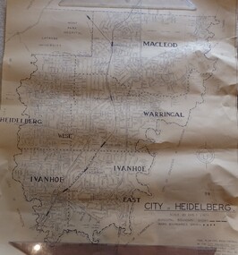
Map, City of Heidelberg. Engineers Dept, City of Heidelberg, 1960s
Map of the City of Heidelberg from the Yarra River in the South to North of Watsonia Military Camp. Shire of Diamond Valley is shown to the north.Map showing municipal and ward boundaries, black text on light brown paper."Scale: 20 CHS = to 1 IN"city of heidelberg -
 Tatura Irrigation & Wartime Camps Museum
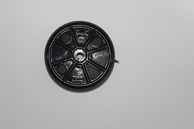
Article - Book Photocopy, John Stewart Dethridge
Excerpt telling the story of John Stewart Dethridge and the Dethridge Meter adopted for standard use by the State Rivers and Water Supply CommissionPhotocopied section of a book on 2 pages with picture of J. S. Dethridge and the Dethridge Meterdethridge, irrigation, dethridge meter, dethridge wheel, j. s. dethridge, john stewart dethridge, john dethridge -
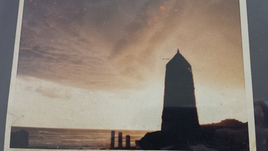 Peterborough History Group
Photograph - James Irvine Memorial
Photograph of the Memorial to James Irvine, Hotel Proprietor, who drowned whilst crossing the Curdies River. The Memorial was erected by the towns people.Significant because it is a memorial to a respected notable resident of the town who tragically drowned crossing the Curdies River 4 x 6 inch sepia photograph of the sunset with James Irvine Memorial in the foreground. Date unknown but appears to be taken prior to footpath and fencing renovations.curdies river, james irvine, peterborough, james irvine memorial -
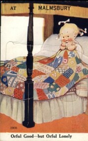 Malmsbury Historical Society
Postcard (Item), "Postcard For Malmsbury, Girl In Bed & Fold Out Scenes C1940", Malmsbury c1940
Associated with - Valentines Novelty Postcard Buildings - Gates/Hotel/River People - "Attwell, M L C, Jessie Swainston Collection" -
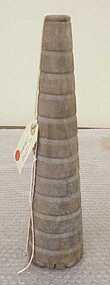 National Wool Museum
Spindle
Was found washed up on bank of Barwon River at Marshall. Object is marked GK probably an abbreviation for Geelong Knitwear or George Kinnear.GK -
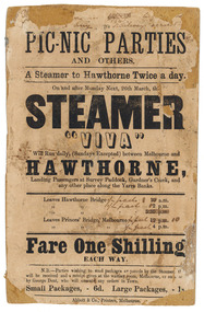 Parliament of Victoria
Flyer for the steamer Viva, Abbott & Co., Printers, c.1860
The "Viva" was a steamboat operated by George Dent that ran on the Yarra River between Princes Bridge and Hawthorn Bridge from 1860-1861. Printer flyer pasted onto cardboard advertising ferry services between Melbourne and Hawthorne [sic]. Corrections to ferry departure times are in black handwritten ink. Flyer has losses around edges and stains from 'blue-tack' verso. Black ink, printed recto: "PIC-NIC PARTIES/ AND OTHERS./ A Steamer to Hawthorne Twice a day./ On and after Monday Next, 26th march, the/ STEAMER/ "VIVA"/ Will Run daily, (Sundays Excepted) between Melbourne and/ HAWTHORNE,/ Landing Passengers at Survey Paddock, Gardner's Creek, and/ any other place along the Yarra Banks./ Leavers Hawthorne Bridge 10 a.m./ 2 p.m./ 5.30 p.m./ Leaves Princes' Bridge, melbourne 12 p.m./ 4 p.m./ Fare One Shilling/ EACH WAY./ N.B.-Parties wishing to send packages or parcels by the Steamer th(?).../ will be received and a receipt given at the waiting room, Melbourne, or on board.../ by George Dent, who will execute any orders in Town./ Small Packages, - 6d. Large Packages, - 1s/ Abbot & Co., Printers, Melbourne.viva steamboat, dent, george, hawthorne, yarra river, princes bridge, melbourne, survey paddock, gardner's creek -
 Melbourne Legacy
Film, Light Horse troops 1940, 1940
A film of Light Horse troops on training manoeuvres in a bush setting by a river in 1940. Full details are not known until the film is played. A record of military manoeuvres in 1940. The link to Legacy is not known but possibly very rare footage.Film on a black metal spool.Spool, Kodak A/asia. Not for camera use. (printed on both sides).world war two, soldiers -
 Bendigo Historical Society Inc.
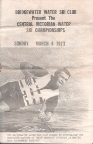
Pamphlet - Aileen and John Ellison Collection: Bridgewater water ski club
Established in 1960 on the Loddon River, the Bridgewater Water ski Club includes a general skiing area, a slalom course and a jumps course.Small pamphlet. Bridgewater water ski club present the Central Victorian water ski championships. Sunday March 4, 1973. on the front cover a male water skier and, on the back, a female one. The pamphlet lists the various categories and the names of the competitors. bridgewater, water ski club -
 Surrey Hills Historical Society Collection
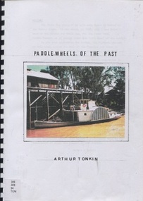
Book, Paddle wheels of the past
The discovery of inland waterways during the early settlement of Victoria and South Australia led to trade being plied up and down the rivers.An A4 80 page comb bound book.paddlewheels, paddlesteamers - murray river (nsw- sa), boats, punts, barges -
 Vision Australia
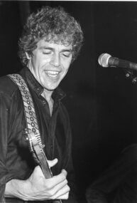
Photograph - Image, Beeb Birtles
Portrait photograph of Beeb Birtles most likely supplied for Carols by Candlelight program when the Little River Band appeared in 1982.B/W photograph of Beeb Birtles.beeb birtles, carols by candlelight -
Greensborough Historical Society
Photograph - Photograph - Digital Image, Marilyn Smith, Greensborough tennis courts 2021, 15/12/2021
Digital image of tree at Greensborough Tennis Courts 15/12/2021, This image shows the trimmed tree near the Plenty River.Part of a collection of miscellaneous historical images with a connection to the local area.Digital colour photograph. greensborough tennis courts, plenty river -
 Kew Historical Society Inc
Photograph - Demolishing the Zig-Zag Bridge, 1929
Henry Beater Christian (1886-1962) , was a descendant of one of the earliest settler families in Kew. Employed at the Kew Asylum as a 'public servant', he was a skilled amateur photographer, photographing numerous scenes in Kew and on his travels around Victoria. The majority of his photographs date from 1916 to 1929. His finest photographs are housed in two photograph albums. Rare photograph of the demolition of the Zig-Zag Bridge linking the two asylums on either side of the Yarra River.Digital copy of a photograph from page 16 of the 47-page photograph album containing 261 gelatinous silver images, loaned by Diane Washfold with permission given to digitise and hold a copy in our collection. The Zig-Zag Bridge linked the grounds of the Yarra Bend and Kew Asylums. The wooden bridge was constructed in the 1870s and lasted through numerous floods until its destruction in 1929. A horizontal structure, the walkway was reached via a wooden staircase on the Kew bank of the river. The steps were required due to the different levels of the banks on this stretch of the river. This is a photo of the bridge before part of it was destroyed in a flood in 1929. A man, perhaps Henry Christian, stands at the right of the foreground."Demolishing Zig-Zag / 6. 1929"henry beater christian (1886-1962), landscape photography, kew (vic.) — yarra river, christian-washfold collection, photograph albums, zig-zag bridge -
 Wodonga & District Historical Society Inc
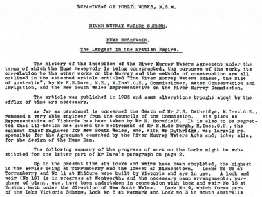
Album - Hume Reservoir Australia Album - Introduction - Part 1, Department of Public Works, N.S.W, 1927
This set of photos is from a leather bound album bearing the inscription "HUME RESERVOIR AUSTRALIA" plus 'The Rt. Hon. L. C. M. S. Amery, P. C., M .P.' all inscribed in gold. It was presented to The Rt. Hon. L. C. M. S. Amery, P. C., M. P, Secretary of State for Dominion Affairs on the occasion of his visit to the Hume Reservoir on 2nd November 1927. This album is of local and national significance as it documents the planning and development of the Hume Reservoir up to 1927. It was the largest water reservoir in the British Empire. The album records the pioneering engineering work that went into its construction.RIVER MURRAY WATERS SCHEME, HUME RESERVOIR THE LARGEST IN THE BRITISH EMPIRE. ' The history of the inception of the River Murray Waters Agreement under the terms of which the Hume Reservoir is being constructed, the purposes of the work, its correlation to the other works on the Murray and the methods of construction are all outlined in the attached article entitled “The River Murray Waters Scheme, the Nile of Australia”, by Mr H.H. Dare, M.E., M.Inst.C.E., Commissioner, Water Conservation and Irrigation, and the New South Wales Representative on the River Murray Commission. The article was published in 1925 and some alterations brought about by the efflux of time are necessary. As far as personnel is concerned, the death of Mr J.S. Dethridge, M.Inst.C.E., removed a very able engineer from the councils of the Commission. His place as Representative of Victoria has been taken by Mr R. Horsfield. It is also to be regretted that ill-health has caused the retirement of Mr E.M. de Burgh, M.Inst.C.E., the eminent Chief Engineer for New South Wales, who, with Mr Dethridge, was largely responsible for the Agreement cemented by the River Murray Waters Acts and, inter alia, for the design of the Hume Dam. The following summary of the progress of work on the Locks might be substituted for the latter part of Mr Dare’s paragraph. Up to the present time six locks and weirs have been completed, the highest in the series being at Torrumberry and the lowest at Blanchetown. Locks No.26 at Torrumberry and No.11 at Mildura were built by Victoria and are in use. A lock and weir (No.10) is in progress at Wentworth, and the necessary camp arrangements, purchase of plant, etc., have been undertaken in connection with lock and weir No.15 at Euston, both under the direction of New South Wales. Lock No.9, which forms part of the Lake Victoria Scheme, Lock No.5 at Renmark and Lock No.3 in South Australia hume reservoir australia, river murray waters scheme -
 Orbost & District Historical Society
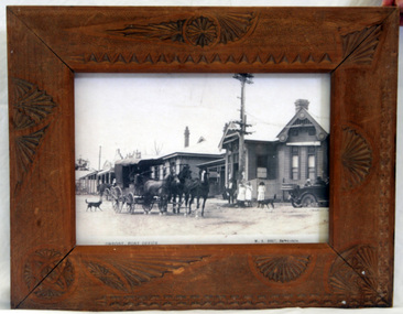
framed photograph, Vogt. W.S, 1917
This photograph was on display in the Orbost Information Centre - the Slab Hut - for many years. Originally the post office was not at Orbost at all but in the small settlement of Newmerella. The building in the photograph was completed and opened in 1898 at a cost of 1038/4/8 pounds. The post office building today is a replica of this building, opened in 2004 after a local campaign to retain a full post office in the town.The photograph of the early post office shows that it was a popular meeting place. Today's post office is a replica of this one and stands on the same site.A framed photograph of the Orbost Post Office (photocopy?) in 1917. The glass was cracked and has been removed. The frame is a wooden one with carved shell shape decorations. In the foreground of the photo is a horse and coach and an early model car. The mail coach is on its way to Cann River. In the car is the Warren family.W.S. Vogt, Bairnsdaleorbost post-office -
 Flagstaff Hill Maritime Museum and Village
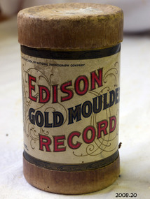
Gramophone cylinders, National Phonograph Co, Old Black Joe, July 29 '02
Gramophone cylinders, black, 6 grooves on interior stored in cardboard round container with detachable lid. Edison Gold Moulded Record, made and sold by National Phonograph Co. at Orange N.J. U.S.A. A - Old Black Joe B - Swanee River Quartette. Pat July 29 '02flagstaff hill, warrnambool, shipwrecked-coast, flagstaff-hill, flagstaff-hill-maritime-museum, maritime-museum, shipwreck-coast, flagstaff-hill-maritime-village, gramophone cylinders, edison gold moulded record, edison record, national phonograph co, old black joe, swanee river quartette -
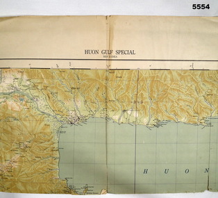 Bendigo Military Museum
Map - MAP, HUON GULF AREA, Aust Survey Corps et al, Aug 43
Refer Cat 5547 - Matheson.This is a single sided map, printed in colour. Scale 1:253,440, 4 miles to an inch, grid squares are 10mm x 10mm. Top right side shows Finschafen. Top centre is Lae, Middle is Salamau. Bottom is Lasanga Island. Top left vicinity is Nadzab and Markham River.There are four "corner" marks in pencil. Two on land and two out in the gulf.ww2, new guinea, map -
Glenelg Shire Council Cultural Collection
Photograph - Compact Disk, 1920-1970
Compact disk of images of Portland and District 1920s-1970s. 54 images including Harbour, Foreshore, High School, Street scenes, ships, trains, harbour opening parade, mounted police 1949, construction of bridge over Surrey River 1954, etc. CD in clear plastic case.compact disk, photography, photography, portland photography -
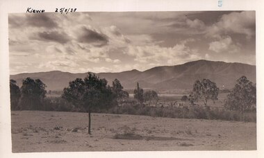 Kiewa Valley Historical Society
Black and white photograph of farmland, Kiewa, 25/8/38, circa 1938
This photograph was taken in August, 1938 some eight years prior to the establishment of Mt. Beauty as a township. The area was still being used for grazing, and the land was eventually acquired from the local land owners by the State Electricity Commission. The construction of the road, from Tawonga to the High Plains, was commenced in April of this year. This allowed men and heavy equipment to be transported to the work sites for the construction of the Kiewa Hydro Electric Scheme This photograph is important as it shows the upper Kiewa Valley as it was before the establishment of the town of Mt. Beauty. The land has been cleared of natural growth and has been used for grazing cattle. By 1946 housing construction had commenced for the new town of Mt. Beauty and by 1948 street construction in the southern part of the town was completed as far as Hill Street.A black and white photograph of farmland with Mt. Emu in the background. This has been taken from where Mt. Beauty township now stands prior to road making and the erection of houses. A line of trees below the hill line indicates the position of the East Kiewa River. (No. 5 in a set of 8) Handwritten in black ink on the upper left corner of the photograph is the inscription 'Kiewa 25/8/38' and the number 5 has been stamped on the upper right hand corner. On the back is the word 'Velox' which is the name of the photographic paper on which the photo was developed.road construction, kiewa, tawonga, mt. beauty, secv