Showing 4217 items
matching creek street
-
 Kew Historical Society Inc
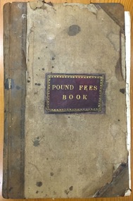
Administrative record (item), Borough of Kew, Pound Fees Book, 1874-1896
While the first successful land sales in Boroondara occurred in Hawthorn in 1843, and Kew in 1845, these areas were to be without local pounds until April 1858, when the Governor of Victoria, in accordance with Act 18 Victoria No 30, was pleased to direct the establishment of a Pound at Glass’s Creek on that part of land bounded by the Kilby Road, Burke Road and High Street. While the Governor was required to proclaim the establishment of a pound, the appointment of a poundkeeper was the responsibility of the Justices of the Peace in the local Court of Petty Sessions. The Pound took its name from the most distinctive natural feature of the area, Glass’s Creek, named after the early pastoralist Thomas Glass.The register is of historic significance as an indicator of suburban life in the second half of the 19th Century. It shows how farming and city life on the urban fringe were intimately connected. It is also significant to the early history of Hawthorn and Kew, who both claimed the Pound following their separation from the Boroondara Roads Board in 1861."Kew Pound Book"glass creek pound (kew), animal pound, dog pound, kew pound, j. smith, john oakes, samuel b. cash, edward s. delaney, emma oswin, samuel cash -
 Kew Historical Society Inc
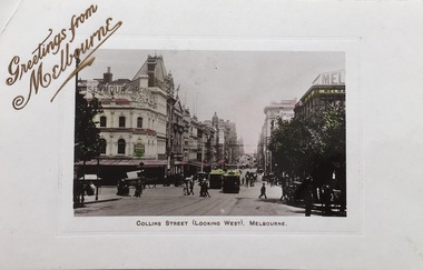
Postcard, Collins Street (looking West), Melbourne, 1907-1914
The Kew Historical Society's postcard collection includes views of Kew, Melbourne and Greater Melbourne as well as those including overseas scenes sent or received from Europe or the Middle East. They date from the 1890s to the 2000s. These postcards may or may not include the name of the publisher or printer. A number of the cards were published as parts of popular series. A way of dating early postcards is to identify whether the reverse was divided by a central line which became the norm after 1902 in the United Kingdom. However, other postcards produced after this date do not always conform to this print layout.Early postcard of MelbourneSepia tinted postcard of Collins Street, Melbourne, Th postcard design includes a line separating the address from the message on the reverse, which dates it after 1902. The stamp on the card is a red Victorian stamp with the head of Queen Victoria in use 1901-1911.Front title - Collins Street (looking West), Melbourne Reverse. - Mrs Garahy, Creek Parade, Clunes, Vic / Dear Mollie / All join with me in wishing you and our dear mother a very prosperous and happy New Year. I am enjoying my holidays very much. I heard Melba last week and went to the pantomime Humpty Dumpty. - it was all lovely. I’ll tell you all about them when I return to Clunes. We were all home for Xmas Day. The first time for 17 years. Fondest love. N.C. / I cut my right hand very badly last Monday and have not been able to write till today. N.C.postcards -- melbourne (vic.), collins street --- melbourne (vic) -
 Kew Historical Society Inc
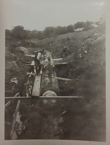
Photograph, City of Kew, City of Kew, Cecil Street Drain, 1936
An original photograph donated to the Kew Historical Society by the City's Engineering Department following the amalgamation of Kew into the City of Boroondara. While not all of the photographs are of Studley Park, Kew or East Kew, each photo provides a fine snapshot of the work of local government engineering departments of the period. They reveal they types of labour conducted, the techniques used and the equipment and machinery in the possession of the local government authority. Historic and rare photograph of major public works in Kew in the 1930s.Public works. Men at work in the creek bed of Connor's Creek in Kew, while constructing the underground drain. Connor's Creek was one of the two main tributaries of the Yarra River in Kew. It originated somewhere near the grounds of Genazzano FCJ College. The barrel drain was finally completed in 1941 at a cost of £14,000. Inscription on reverse: "City of Kew / Cecil st drain / November 1936". city of kew, city of kew (engineering department), engineering, connor's creek (kew) -
 Kew Historical Society Inc
Album - Photographs of heritage sites in Victoria, Eva Grant, 1964-66
Eva Grant was a member of the Kew Historical Society. Three albums in the collection were created by her, this one, the third created between 1964 and 1966. They were donated to the Society by her daughter in 2010. Each of the albums includes photographs and newspaper cuttings collected on her travels to historic places in South East Australia in the 1950s and 1960s. Particular structures photographed in this album include: Barnawatha (Vic.) - The Hermitage | Beveridge (Vic.) - Stone cottage where Ned Kelly was born. | Brighton - St Andrew’s Church graveyard. | Chiltern (Vic.) - lake view [missing] | Cowes (Vic.) - ‘Broadwater’ [originally home of Henty-Wilson family], demolished 1965; Bell of the Speke wreck; Edward’s tree. | Euroa (Vic.) - Habbies Howe | Fairfield (Vic.) - Dight’s Falls; John Dight. | Fernshawe (Vic.) - Queen Mary tree. | Jolimont (Vic.) - Old railway tunnel linking the first Government House (1964); Sign identifying location of first Government House. | Kew (Vic.) - Cairn at Dight’s Falls; Canoe tree, Bowyer Avenue. | Kyneton - De Grave’s Flour Mill - “C”. | Maldon (Vic.) - Chinese oven; Macarthur’s House; Maldon’s oldest resident; Chinese graves x 2; [Beehive Chimney]. | Marysville (Vic.) - Centenary cairn | Mitcham (Vic.), Mud brick house x 2, Deep Creek Road. | Melbourne (Vic.) - St Paul’s Cathedral [renovation] (1964); Wreckers at Damman’s Corner, cnr Bourke and Collins Streets (1964); Princess Gate project x 2 (1964); Colonial Storekeeper’s building on cnr King and Bourke Streets (1966); Early observatory 1861-3; the Honey Memorial. | Mt Oberon (Vic.) - [obsolete] radio telephone dish. | Seymour (Vic.) - Habres (sic) House x 3.| Swan Hill (Vic.) - Major Mitchell’s Cairn (12/1964); Headstone of Andrew Beverage AM (12/1964). | Templestowe (Vic.) - Finn’s Hotel. | Thornton (Vic.) - Eildon Station. | Werribee (Vic.) - Chirnside Memorial [Presbyterian] Church; gaslight beside church | Location unknown, but possibly Swan Hill - Brick house; Wooden bullock dray. | Location unknown - Headstone of John Furlonge 1835.Important record of significant heritage properties in Victoria, many of which have since been demolished.30 page spirex bound drawing book including photographs and newspaper articles of historic buildings in Victoria. The front cover has a picture of a steam boat. The cover is encased in plastic. A number items in the album are annotated with written commentary by Eva Grant who compiled the album. Annotations and transcriptions by Eva Grant on most imageseva grant, photograph albums, heritage places - victoria -
 Kew Historical Society Inc
Album - Photograph Album No.1, Henry Beater Christian, 1924-26
Henry Christian (c.1809-91), the grandfather of the photographer, was one of the first settlers in Kew. He arrived in Victoria with his wife Agnes and son Orlando in 1855 on the Gypsy Queen. He established a rope-making business in Bulleen Road by 1858 but was declared insolvent two years later. In his final years, he was celebrated as one of the oldest living settlers of the district. His son, Orlando Henry Beater Christian (c.1853-1930) became a member of the Hawthorn Band and a foundation member of the Willsmere Swimming Club. Orlando and his wife Elizabeth had four children of which Henry Beater Christian (1886-1962) was the oldest.An album of photographs, compiled by Henry Beater Christian (1886-1962) of Pakington Street, Kew, depicting individuals, natural and settled environments and the interactions between these worlds. Henry Christian, was a keen explorer, not just of his immediate environment but also of the Victorian wilderness. His major opus is contained in two albums in which he records, sometimes in majestic detail and on other occasions the intimate features of the natural world. His photographic travels during the 1920s, often in solitary ramblings but on other occasions with companions, recall the heroic landscape photography of an earlier era, pioneered by Nicholas Caire. In addition to their aesthetic value, the albums are historically significant records within the State of Victoria, of what is now a distant point in time, and of places that have become radically altered through human intervention.Digital copy of a 47-page photograph album containing 255 gelatinous silver images, loaned by Diane Washfold with permission given to digitise and hold a copy in our collection. The album contains a groups of photographic positives taken by Henry B Christian (a resident of Pakington Street), of places in Kew and throughout regional Victoria during the 1920s. The mainly sepia photographs, while small, are of a high resolution. Photographs are typically lightly glued onto pages. Locations are frequently identified by white or black ink, which in a number of cases is illegible due to wear.henry beater christian (1886-1962), landscape photography, photograph albums, kew (vic.) — yarra river, kew (vic.) — zig-zag bridge, kew (vic.) — macauley’s boathouse, studley park (vic.) — yarra river, wonderland — grampians (vic.), black spur (vic.), marysville (vic.), maroondah dam (vic.) — construction, warburton (vic.), cockatoo (vic.), bruthen (vic.), swan reach road (vic.), glen hills (vic.), lightning creek (vic.), omeo (vic.), glen wills (vic.), mt wills (vic.), sunnyside (vic), granite flat (vic.), toolangi (vic.), yea (vic, )., flowerdale (vic.), mt white law (vic.), baw baw (vic.), christian-washfold collection -
 Kew Historical Society Inc
Photograph - Civic event in Stradbroke Park, 1976
Stradbroke Park. Extent: Kilby Road to Harp Road at Burke Road. Historical Documentation: 1851 - Portion 91 purchased by Edward Glynn; 1888 - The Harp of Erin Estate (which included Section 91) offered for sale; 1896 - The area now known as Stradbroke Park was bisected by a creek that flowed from the Yarra via Hay's Paddock (q.v.) and extended through to Burke Road; 1943 - W.D. Birrell, Town Clerk of Kew, proposed that the creek be filled and a reserve created; 1954 - Entire area designated as 'open space' and named 'Stradbroke Park'. The line of the creek that ran through the Park created a further reserve on the north side of High Street, now known as 'Harrison Reserve'. Existing Condition: The park is largely of mown grass that has mature trees set into it It is possible that a number of these are remnant of the original vegetation, while there are also a number of exotic trees introduced, particularly at the northern end of the park. The southern end is dominated by playing fields. (Source: Sanderson, P 1988. Kew Conservation Study)Colour photographic positive (with colour degradation) of sporting teams at a civic event in Stradbroke Park in Kew East in May 1976. The event was officiated by the Mayor of Kew, Cr Alan Hutchinson. Sporting teams in uniform included: footballers, athletes, cricketers, hockey players. Stradbroke Park is situated on the western boundary of Kew at Burke and Harp Roads.stradbroke park, cr alan hutchinson, team sports -- kew (vic.) -
 Kew Historical Society Inc
Photograph - Civic event in Stradbroke Park, 1976
Stradbroke Park. Extent: Kilby Road to Harp Road at Burke Road. Historical Documentation: 1851 - Portion 91 purchased by Edward Glynn; 1888 - The Harp of Erin Estate (which included Section 91) offered for sale; 1896 - The area now known as Stradbroke Park was bisected by a creek that flowed from the Yarra via Hay's Paddock (q.v.) and extended through to Burke Road; 1943 - W.D. Birrell, Town Clerk of Kew, proposed that the creek be filled and a reserve created; 1954 - Entire area designated as 'open space' and named 'Stradbroke Park'. The line of the creek that ran through the Park created a further reserve on the north side of High Street, now known as 'Harrison Reserve'. Existing Condition: The park is largely of mown grass that has mature trees set into it It is possible that a number of these are remnant of the original vegetation, while there are also a number of exotic trees introduced, particularly at the northern end of the park. The southern end is dominated by playing fields. (Source: Sanderson, P 1988. Kew Conservation Study)Colour photographic positive (with colour degradation) of sporting teams at a civic event in Stradbroke Park in Kew East in May 1976. The event was officiated by the Mayor of Kew, Cr Alan Hutchinson. Stradbroke Park is situated on the western boundary of Kew and bordered by Burke and Harp Roads.stradbroke park, cr alan hutchinson, team sports -- kew (vic.) -
 Sunbury Family History and Heritage Society Inc.
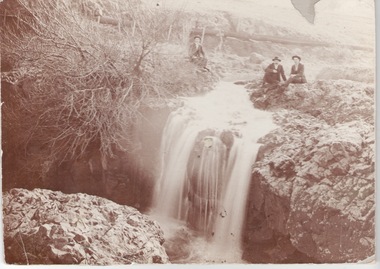
Photograph, c1910
The men are sitting above the waterfall and the Jacksons Creek close to the site of the former mill which utilised the water from the river to power the mill machinery.A sepia photograph mounted on cardboard of three men sitting on a river bank above a waterfall with a pipeline in the background.jacksons creek, sunbury -
 Sunbury Family History and Heritage Society Inc.
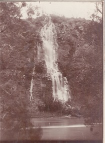
Photograph, c1920s
The waterfall is cascading down the Johnson Cliff which is on the Jacksons Creek downstream from Sunbury town.A sepia photograph with a narrow cream border mounted on cardboard of a waterfall cascading into the river below. johnsons cliff, jacksons creek, waterfalls -
 Sunbury Family History and Heritage Society Inc.
Photograph, 18 October 1978
George and Anne Evans settled in Sunbury in 1836 after migrating to Van Diemens Land from Plymouth in 1825. He took upland along the Jacksons Creek and built his Emu Bottom Homestead. He married Anne, who was forty years younger than him on 11 May 1843 and they had six children. He and his wife Anne are buried in Melbourne General Cemetery in Compartment 'H'.George died on 26 August 1876 and Anne died on 12 January 1893. George Evans was a one of the first Europeans to take up land in the the area that was originally known as Buttlejork ( Batterjork) in the area now known as Sunbury. A black and white photograph with a cream border of the headstone of George and Anne Evans.evans, george., evans, anne., emu bottom, headstones -
 Sunbury Family History and Heritage Society Inc.
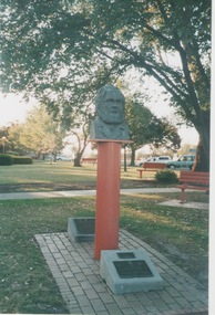
Photograph, 2011
The statue is a bust of George Evans who settled in Sunbury along the Jacksons Creek and built a homestead which he named 'Emu Bottom'. The statue was originally erected on the site in 1986 to commemorate the 150th anniversary of European settlement in the area. A time capsule was buried at the base of the statue and was lifted and opened in 2011 when the 175th anniversary was celebrated. After that event a second capsule was buried along with the original one.A coloured photograph of a statue of the bust of a bearded man set in a brick paved block in a garden. There are two plaques at the base of the statue.evans, george., anniversaries, sunbury -
 Sunbury Family History and Heritage Society Inc.
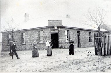
Photograph, Ball Court Hotel
... built along Macedon Street between Jackson Creek and Evans ...The hotel was built some time shortly after 1842 by John Cahill, who arrived in the colony in 1842 from Thurles in Tipperary, Ireland. The building although much altered with render covering the original \blue stone structure is on the south-west corner of Macedon and Jackson Streets. The hotel was called the Ball Court because Cahill also had a hand-ball court set up behind the hotel.Originally five hotels were built along Macedon Street between Jackson Creek and Evans Street. The Ball Court Hotel is the only one still standing and operating as a hotel.A non-digital black and white photograph with a cream border of man and three ladies standing outside a single story blue stone hotel building with a corner entrance. AS well as the corner entrance there is another doorway on the RHS along with three narrow windows and three other windows on the other side. One of the ladies is holding a little child. Two trees surrounded by tree guards are on each side of the photograph.Ball Court Hotel, John Cahillball court hotel, hotels, sunbury, macedon street, jackson street, ball court -
 Sunbury Family History and Heritage Society Inc.
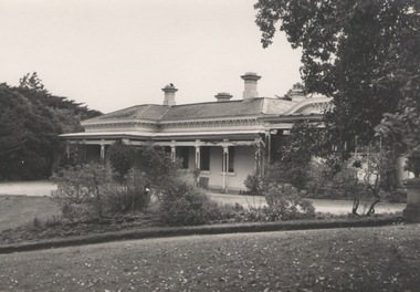
Photograph, 'Glenara' Homestead, 20 August 1952
"Glenara' was the home of Alistair Clark who lived at Bulla which is situated about 20 kms NW of Melbourne in the Deep Creek valley. He was born there in 1864 and lived there throughout his lifetime until his death in 1949. His father established the property during the mid-nineteenth century. Alister Clark was a rose grower and created the very popular 'Lorraine Lea 'rose along with other famous species. A rose garden has been established in the township of Bulla in his memory. He was also an active member of the Victorian Racing Club. The original photograph was published in the Melbourne 'Herald' on 20 August 1952 on page 5.Alistair Clark was a prominent rose grower and developed many rose species which were suitable for Victorian conditions. The homestead is a good example of Victorian architecture built in Victoria in the latter years of the nineteenth century. The house has a heritage listing in the City of Hume Heritage Study.A black and white photograph with a fine white frame, of a Victorian homestead with a a verandah across the front of the house. It is set in a spacious garden with garden beds, lawn and trees.clark, alistair, 'glenara' homestead, roses, bulla, deep creek -
 Sunbury Family History and Heritage Society Inc.
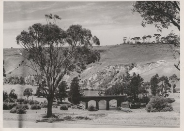
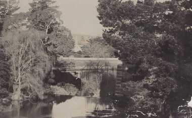
Photograph, Bulla Bridge, 12 July 1944
The photograph was taken looking across the Deep Creek valley with the three-arched stone bridge spanning the river.A black and white photograph with a white border of a deep river valley with a three-arched bridge spanning a river. A gum tree is in the foreground. -
 Sunbury Family History and Heritage Society Inc.
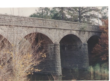
Photograph, Bulla Bridge, c 1980s
The bridge in the photograph is the bluestone bridge at Bulla which spans the Deep Creek, a tributary of the Maribyrnong River. It was built in 1869 and replaced a ford crossing which was built further downstream. Many of the buildings and structures in the area were built from bluestone which is in abundance throughout this volcanic area.This bridge is one of many similar structures built across Western Victoria where the bluestone volcanic rock was found in abundance.A coloured close - up photograph of a four-arched blue stone bridge spanning a waterway. Some greenery is visible on either side of the bridge and above it. bulla bridge, bluestone, bridges, deep creek. -
 Sunbury Family History and Heritage Society Inc.
Photograph, Bulla Bridge
A coloured photograph of the bluestone bridge which spans Deep Creek at Bulla. The photograph is taken facing upstream. The bridge was constructed in 1869 and replaced a ford crossing further downstream. Many bridges in the South West of Victoria were constructed from Bluestone basalt rock because the area is on a large volcanic plain and that rock is in abundance. A coloured photograph of the Bulla Bridge which spans the Deep Creek at Bulla. Photograph 0178 is an identical photograph tho this one.bridges, bulla bridge -
 Sunbury Family History and Heritage Society Inc.
Photograph, Bulla, C 1980s
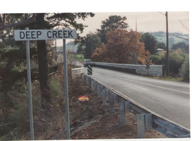
The photograph shows the approach to the Bulla Bridge at Deep Creek in the Township of Bulla. Immediately on crossing the bridge there is a sharp bend in the road and a step ascent up Bulla Hill through the cutting until level ground is reached. The photograph is looking to the NW. Deep Creek meets the Maribyrong River further downstream and closer to Keilor.The bridge and road replaced the ford crossing in 1869 that was downstream from the bridge.A coloured photograph of the approach to a bridge over the Deep Creek at Bulla along Sunbury Road. bulla bridge, deep creek, sunbury road -
 Sunbury Family History and Heritage Society Inc.
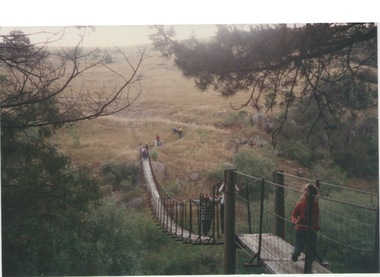
Photograph, Catanery Bridge, Bulla, c1980s
The narrow swing catanery bridge was built behind the school across the Deep Creek downstream from the bluestone Bulla Bridge. It was built so that children who lived on the south side of Bulla Township could access the school more easily and in shorter time than if they had to go by the main roads.The bridge was constructed in the days when most children walked to school. The use of this bridge cut the children's travel time and distance to school quite considerably and was used for many years until the school was closed in 1996.A coloured photograph of the children on a narrow swing bridge and the path they used to approach the bridge over open ground. bulla primary school, swing bridge, bridges, catanery bridge -
 Sunbury Family History and Heritage Society Inc.
Photograph, River studies
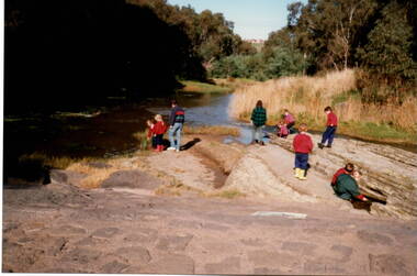
Students from Bulla Primary school were taken to the nearby Deep Creek to study some of the river life inn the local water course.Bulla township is situated in the Deep Creek valley and was an ideal place to take students to study river life close to their school.A coloured photograph of eight children with two adults standing on a rocky outcrop beside a river and looking at the riverlife in the water.rivers, deep creek, river studies, bulla, bulla primary school -
 Sunbury Family History and Heritage Society Inc.
Photograph, c 1910
The photograph was taken from the iron bridge on the Rupertswood Estate. The tower of the Rupertswood Mansion can be seen in the distance. The Eadie family were business people and millers in Sunbury.A post card featuring a dark sepia image of a creek with a large house in the distance. There is a hand written message on the back.Written on the back: Dear old boy Many happy returns of the 8th. I . . . . . . . . . . . . making the . . . .Yours ever Will. Iron bridge at Rupertswood. Mr Hal Eadie Dannevirke NZ.rupertswood mansion, jacksons creek -
 Sunbury Family History and Heritage Society Inc.
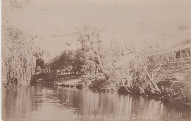
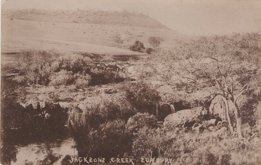
Photograph
The postcard features a view of the Jacksons Creek in Sunbury. Before settlement, Jacksons Creek was the main source of water in Sunbury. It flows from the Macedon Ranges and is an important arm of the Maribyrnong River. A sepia photograph in post card format of a view of a river in the country. JACKSONS CREEK SUNBURYjacksons creek, sunbury -
 Sunbury Family History and Heritage Society Inc.
Photograph, SUNBURY BATHS
The scene featured on the post card is a view of The Nook on the Jacksons Creek. For many years before the Aquatic Centre was build in the town, The Nook was the swimming place for local residents. The surrounding area had seats and change rooms. The Sunbury Swimming club was established at this site before the Aquatic Centre was built.A sepia photograph in post card format of river bend and small sandy beach on the bank.the nook, swimming -
 Sunbury Family History and Heritage Society Inc.
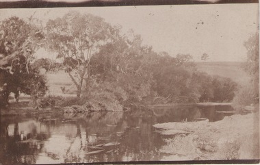
Photograph
... which are downstream from Macedon Street. Jacksons Creek sunbury ...he photograph was taken of Jacksons Creek near the waterfalls and weir which are downstream from Macedon Street.A sepia photograph in postcard format of a creek with the water tumbling over rocks. The land in the distance rises above the surrounding valley.JACKSONS CREEK SUNBURYjacksons creek, sunbury -
 Sunbury Family History and Heritage Society Inc.
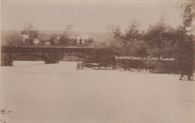
Photograph
... Street bridge Jacksons Creek Goonawarra Winery JACKSON'S CREEK ...The post card is a record of a time when the Jacksons Creek flooded and the water almost reached the two arches on the Macedon Street Bridge. The Goonawarra Winery buildings can be seen in the back ground.A sepia photograph in post card format of a river in flood with the water almost reaching the two arches on the stone bridge. Farm buildings can be seen in the middle distance.JACKSON'S CREEK IN FLOOD SUNBURYmacedon street bridge, jacksons creek, goonawarra winery -
 Sunbury Family History and Heritage Society Inc.
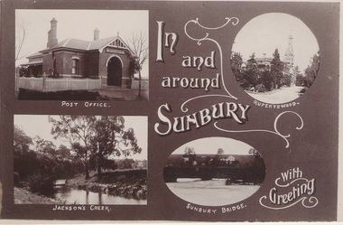
Photograph
... including the post office, Rupertswood Mansion, Macedon Street... Mansion, Macedon Street Bridge andJacksons Creek. A greeting ...A post card featuring four were known scenes of Sunbury including the post office, Rupertswood Mansion, Macedon Street Bridge andJacksons Creek. A greeting is also printed on the card.IN/AND/AROUND/SIUNBURY/WITH /GREETINGS -
 Sunbury Family History and Heritage Society Inc.
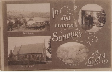
Post Card, Inb and around Sunbury
The post card is one of a set of commercial cards produced for Sunbury. Each card featured particular buildings or places of interest in the town. This card included Ben Eadie winery, Our Lady of Mt. Carmel Catholic Church, the former old mill by Jacksons Creek and the railway viaduct and bridge at Rupertswood. All the buildings featured on the card are of historical significance to Sunbury's early development.A post card featuring a collage four sepia views of Sunbury. The following greeting is written on the card: In and around Sunbury with Greeting. ben eadie winery, our lady of mount carmel catholic church, railway viaduct, the old mill -
 Sunbury Family History and Heritage Society Inc.
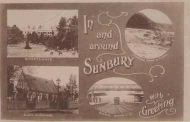
Post Card, In and around Sunbury with Greeting
The post card is one of a set that were produced by Chris Christainsen, who had a pharmacy in Sunbury and was also a photographer. The four photos featured on the card are the Rupertswood Mansion, St Mary's Church of England, Jacksons Creek in floods ands Sunbury Railway station.The buildings and places featured on the card are of historical significance in the Sunbury town precinct. A post card with four sepia photographs of interesting sites which can be seen in the Sunbury township. IN AND AROUND SUNBURY WITH GREETING. christainsen, chris., rupertswood mansion, st. mary's church of england., jacksons creek, sunbury railway station -
 Sunbury Family History and Heritage Society Inc.
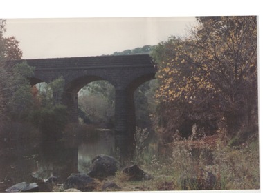
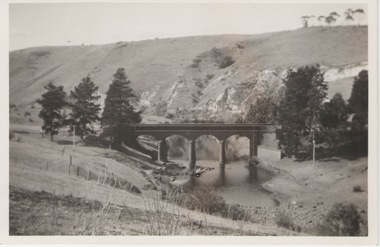
Photograph, 27 June 1934
This is a photograph of the bridge in the Bulla township which spans the Deep Creek, a tributary of the Maribyrnong River. It has been constructed from bluestone which is found across the volcanic western plains in Victoria. Kaolin was quarried from the cliff face in the background and was used in the making of bricks and pottery products manufactured at Northcote and Brunswick potteries.This is one of the many notable bluestone bridges which were built in the district in the nineteenth century.A black and white photograph of a valley with a five arched bridge spanning a river. There are high cliffs in the background.bulla township, deep creek, bridges -
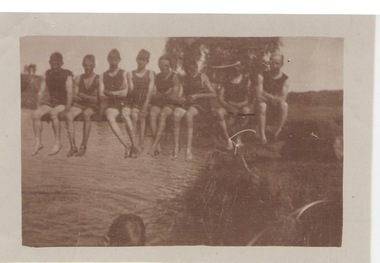 Sunbury Family History and Heritage Society Inc.
Photograph, c1920s
The swimmers were seated on the diving board over Jacksons Creek at The Nook, which served as a swimming pool in Sunbury until 1966 when the long-awaited for swimming pool was officially opened in Ligar Street on19th January 1966. For a number of years before the official opening townspeople organised many fund raising events to pay for the new pool. The pool at The Nook served as a popular swimming place for many years in Sunbury during the summer weather.A sepia photograph with a white border of a group of eight swimmers sitting on a diving board over a river. swimming, the nook, swimming clubs