Showing 10536 items
matching lander
-
 Tatura Irrigation & Wartime Camps Museum
Book, Internees from Iran held in Australia During WW2, 1993
List of Germans and Austrians interned in Persia and brought to Loveday and Camp 1. Includes place of capture and release, occupation and spouse detail. Document prepared by Gerhard Meinke, son of Internee Albert Meinke. Gerhard and his mother were transported over land back to Germany when Albert was interned.Clear plastic cover with title on 1st page. 131 pages data and statistics of the German and other nationals apprehended in Iran in 1941 and interned in Australia during WW2iran internees, ww2 internees, gerhard meinke, albert meinke -
University of Melbourne, Burnley Campus Archives
Article - Photocopy, Horticultural Society of Victoria, 1860
Photocopy of Newspaper Article, Thursday 2 August, 1860 p 7 Report of the monthly meeting of the HSV Municipal Council of Richmond and commissioner of Public Works had granted funds for fencing the gardens and plans for a special meeting as soon as the Department of Lands had granted them land in the Surrey Paddock.Newspaper article from The Argusthe argus, surrey paddock, burnley gardens, horticultural society of victoria, hsv -
Clunes Museum
Photograph - PHOTOGRAPHS AND DOCUMENTS
James Goldsworthy Scholl had a private school in Clunes in early 1870's. He was born in Cornwall, U.K. in 1836 and married Emily Bennett in February 1857. James arrived in Melbourne on the "Agincourt" in November 1863 and Emily in July 1863 on the "Golden Land" James died in 1893 and Emily 19321. Enlarged photo of Mrs. James Goldsworthy Sholl (nee Bennett) Approx 1879 with 5 of 11 children (from left to right Albert 1875, Laura 1864, Emily Scholl, Bertha 1877, Arthur 1870, Anne 1868) 2. Original photo of Emily Scholl 3. Original photo of James Goldsworthy Scholl 4. Copy of parish map showing school location 5. Written account of family historyOn item 2. and 3. Printed gold lettering Yeoman, Paris Panel, Royal Arcade Melbournescholl, goldsworthy, private school, education -
 Yarrawonga and Mulwala Pioneer Museum
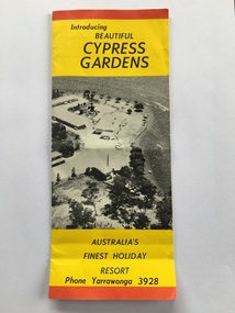
Work on paper - Advertising brochure, Introducing beautiful Cypress Gardens, 1959 to 1966
Cypress Gardens was built by Bert and Flo Foster to encourage holiday makers to visit Yarrawonga Mulwala and enjoy aquatic pursuits. Boats were accommodated. Built in the 1950’s and opened 19th December 1959, demolished around 2000, land sold and luxury homes were built along the lakeside. Four fold coloured ( red, black, blue, yellow) brochure, printed on both sides featuring black and white photos. Taken around about and inside resort buildings. tourism, advertising, aquatic sports -
 Whitehorse Historical Society Inc.
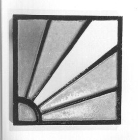
Ceramic - Tile
The Australian Tesselated Tile Co. began in Mitcham, south of the Railway Station, in 1886. It almost collapsed after the bursting of the land boom in 1890s, then recovered to become one of the world's greatest tile works. It made a greater range of tiles than any other known tile works, here or overseas.Glazed mosaic tile with Sunburst design in dark orange, light orange and cream. Edged in black(on back) '495' '6'ceramics, earthenware -
 St Matthews/Wiseman House Archive
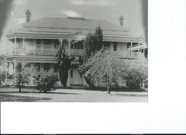
Photograph, Sawbridgeworth 32 Widford Street Glenroy
Sawbridgeworth, 32 Widford Street Glenroy, was built in 1887 by Arthur Wiseman to help promote the sale of land in Glenroy. It was St. Agnes Church of England Girls Home 1922 to 1964. Now called 'Wiseman House' it has been part of the property of St. Matthew's Anglican Church since 1965.Black and white photograph of SawbridgeworthCopied with permissionsawbridgeworth, wiseman house -
 Port Fairy Historical Society Museum and Archives
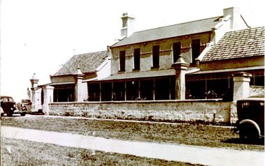
Photograph
The land for this building was granted to the Benevolent Society by James Atkinson in 1850. Tenders were being called for a new "Benevolent Asylum" in 1855, the foundation stone having been laid and by 1856 the first part of the Hospital was completed. this photograph shows there have been extensions to both sides of the hospital by this time 1920Black and white photograph of Exterior of hospital with verandah stone fence and gates two cars hospital, institution, villiers street, benevolent asylum, health service -
 Port Fairy Historical Society Museum and Archives
Photograph
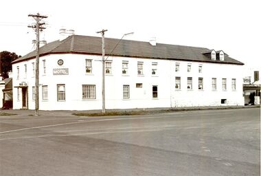
The Stag was built 1848-1854. John Sanders purchased the land from Atkinson in 1848 and built the building as a licensed premises. Over the years it was also used as a Hotel, boarding house and boarding school. It is still used today as Accommodation and a restaurant. This photo has probably been taken in the 1980'sBlack and white Photograph of 2 story building with multi paned windows power pole on corner and telegraph pole to the righthotel, stag, seacombe, inn, john sanders, boarding house, school, coffee palace -
 City of Greater Bendigo - Civic Collection
Programme - Official Olympic Souvenir, G. W. Green & Sons, XVIth Olympiad Melbourne Australia, 22 Nov.- 8 Dec. 1956, 1956
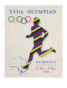
Held in Melbourne from the 22nd November to 8th December, the 1956 Summer Olympics, officially known as the Games of the XVI Olympiad or the Melbourne Olympics were the first held outside of Europe or the USA. This programme was originally enclosed with book 'Australia, Land of the Southern Cross' as is a visitors guide to Australian states and cities.Colour printed programme. 15, [1] pages. Illustrated. Colour printed front and back cover based on the Olympic ring colours. Inside pages printed in red and black. Contents include an official programme listing all the events, venues and dates; photograph and map of Olympic grounds and Village; a guide to facilities and services available to visitors during the Olympic Games and lists of Australian cities and towns with brief statistics and description for each listing. Includes an introduction by Frank Selleck, Lord Mayor of Melbourne ; Maurice A. Nathan, Chairman, Olympic Civic Committee.melbourne olympic games, olympic games 1956, city of bendigo tourism -
 Melbourne Tram Museum
Document, Maidstone Tram Maintenance and Stabling Facility - Proposed Plans - Planning Approval, 2022
Provides the proposed plans for the Maidstone Tram Maintenance and Stabling Facility - Proposed Plans - Planning Approval stage - site plans, perspective, land use and sight lines from various locations. The information booklet looks at the project steps, planning approval, heritage issues, environmental, construction, timing and operations.Yields information about the proposed Maidstone tram depot.Digital copy of a 13 A3 page document titled - Maidstone Tram Maintenance and Stabling Facility - Proposed Plans - Planning Approval and a 12 A4 page Information booklettrams, maidstone, tramways, new depot -
 The Beechworth Burke Museum
Audio - Oral History, Jennifer Williams, John Watson, 22 June 2000
John Watson's story shows insight to the families that moved to Beechworth and the motivation behind this. It showcases the nuances of life in the district and the day to day ways of living. This history speaks of land cultivation and the innovation of industry in the region, in particular cattle farming and butchering. Watson's account speaks of the way that the practice of breeding cattle effects the rural lifestyle, and the hardships that come with working on the land. This oral history recording was part of a project conducted by Jennifer Williams in the year 2000 to capture the everyday life and struggles in Beechworth during the twentieth century. This project involved recording seventy oral histories on cassette tapes of local Beechworth residents which were then published in a book titled: Listen to what they say: voices of twentieth century Beechworth. These cassette tapes were digitised in July 2021 with funds made available by the Friends of the Burke.Watson's account is historically significant due to its ability to illustrate the lifestyle and industry of those in Beechworth during the twentieth century. It is a rare insight into the the practices of residents of this time. This oral history also shows deep insight into the social structure of the community. It describes the family and community dynamics over a long period of time, the motivations behind behaviour, and the greater community fabric. This is a digital copy of a recording that was originally captured on a cassette tape. The cassette tape is black with a horizontal white strip and is currently stored in a clear flat plastic rectangular container. It holds up 40 minutes of recordings on each side.John Watson1800s beechworth, 20th century beechworth, beechworth, farming and agriculture, farm, farm work, farmers, farming, cattle, industry, oral history, john watson -
 The Beechworth Burke Museum
Photograph, 1865
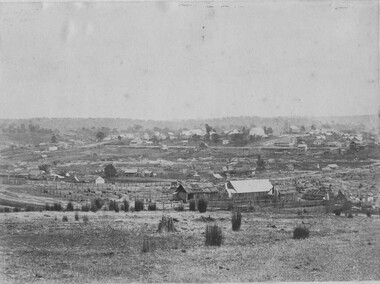
Taken in Beechworth 1865, this photograph depicts the view of the Spring creek with the Beechworth township in the background. This photograph was taken 13 years after the discovery of Gold at Spring Creek. Within eleven months of the discovery in 1852, over 8000 hopeful prospectors had descended on the region, transforming the seemingly undisturbed land into what a visiting journalist in 1880s referred to as; "A Titan's Field". Huge mounds of earth were churned by hundreds of miners in search for gold, almost every available resource the land had to offer was used for something; even the bark off the gums were stripped to line huts and shafts. By 1857 more than 20,000 people lived in Beechworth, and with this influx the town prospered with the building of numerous churches, banks, schools, shops and hotels along with a prison and hospital.Black and white rectangular photograph. Image is printed on matte photographic paper and is mounted on cardboard.Obverse: NO INSCRIPTION Reverse: BMM6925 / BEECHWORTH FROM SPRING CREEK 1865 beechworth, spring creek, gold rush, titan's field, 1865, prospectors -
 Bendigo Military Museum
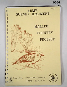
Administrative record - Army Survey Regiment - Malee Country Project 4 Mar - 26 May 1987, Army Survey Regiment, Bendigo, 30 Jun 1987
Project Mallee Country was support provided to Operation Raleigh by members of the Army Survey Regiment during the period 4 Mar - 26 May 1987. This is the report on their activities. Colonel John Blashford-Snell and Prince Charles launched Operation Drake in 1978, running youth projects from ships circumnavigating the globe, to develop self-confidence and leadership through adventure, scientific exploration and community service. In two years 414 young people took part in the round the world voyage, working on land-based projects in 16 countries. Following the success of Operation Drake, the much more ambitious Operation Raleigh was established in 1984, and ran for five years until 1989. The success of Operation Raleigh saw it continue on a permanent basis in 1988, with an emphasis on land-based expeditions.A4 Report, beige coloured cover, brown motif of Mallee Fowl, containing typed paper pages, poor quality photocopied photos and diagrams, unbound.royal australian survey corps, rasvy, fortuna, army survey regiment, army svy regt, asr -
 Warrnambool and District Historical Society Inc.
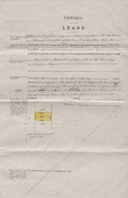
Document, Lease of 317 acres. C & Th Vaughan & A Bostock, 1879
Augustus Bostock was the 9th child of Robert & Rachael Bostock of Vaucluse Epping Forest, Van Diemen’s Land. He was only 4 years old when his mother died. He was inspired by his father to seek his fortune in the Western District of Victoria. He arrived around 1850. He married Margaret Aitkin in July 1865. Augustus owned several properties in the district and leased others. He sat on the court of Warrnambool, Mortlake or Hexham as required. He resided at Marramook in Hawkesdale and later moved to Vaucluse in Hopetoun Road Warrnambool, where he died in 1920 at the age of 87. He was involved in many aspects of life in the Western District, racing, cricket, and social activities to name a few. This lease relates to land at the parish of Ballangeich county of Villiers. This is one of a number of documents which relate to the Bostock family who were one of the most important pioneering families of the Western District. They owned and leased various properties around Warrnambool and were involved in many aspects of social and business life. The document itself is indicative of its time and provides an insight into the details and terms of such documents at the time.Four page beige coloured document showing details of lease and signatures on page 3. Small diagram with area of lease coloured in yellow on front page.Signed by Charles Vaughan, Thomas Vaughan, Augustus Bostock.warrnambool, bostock, augustus bostock, charles vaughan, thomas vaughan, ballangeich, -
 Warrnambool and District Historical Society Inc.
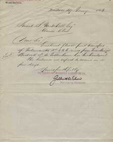
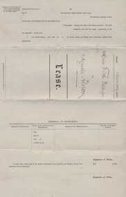
Document and covering letter, Augustus Bostock, 1883
Augustus Bostock was the 9th child of Robert & Rachael Bostock of Vaucluse Epping Forest, Van Diemen’s Land. He was only 4 years old when his mother died. He was inspired by his father to seek his fortune in the Western District of Victoria. He arrived around 1850. He married Margaret Aitkin in July 1865. Augustus owned several properties in the district and leased others. He sat on the court of Warrnambool, Mortlake or Hexham as required. He resided at Marramook in Hawkesdale and later moved to Vaucluse in Hopetoun Road Warrnambool, where he died in 1920 at the age of 87. He was involved in many aspects of life in the Western District, racing, cricket, and social activities to name a few. This document relates to lease of land at Talawanta in Northern NSW This is one of a number of documents which relate to the Bostock family who were one of the most important pioneering families of the Western District. They owned and leased various properties around Warrnambool and were involved in many aspects of social and business life. The document itself is indicative of its time and provides an insight into the details and terms of such documents at the time.000849.1 Handwritten letter on lined paper with The business details printed at the top and purple stamp near signature at the end of letter. Back is blank. 000849.2 Blue foolscap size paper document with outline printed with details handwritten in black ink. 000849.1 signed Gillin Wilson. The Queensland Mercantile & agency Co in red with Wilson Bro & Co in top RH corner. 000849.2 Department of Public Lands, Pastoral Occupation Branch. warrnambool, bostock, augustus bostock, bostock,talawanta,1883, -
 Warrnambool and District Historical Society Inc.
Document, Lease Miss Phillips to Augustus Bostock, Circa 1894
Augustus Bostock was the 9th child of Robert & Rachael Bostock of Vaucluse Epping Forest, Van Diemen’s Land. He was only 4 years old when his mother died. He was inspired by his father to seek his fortune in the Western District of Victoria. He arrived around 1850. He married Margaret Aitkin in July 1865. Augustus owned several properties in the district and leased others. He sat on the court of Warrnambool, Mortlake or Hexham as required. He resided at Marramook in Hawkesdale and later moved to Vaucluse in Hopetoun Road Warrnambool, where he died in 1920 at the age of 87. He was involved in many aspects of life in the Western District, racing, cricket, and social activities to name a few. This lease relates to land in the parish of Minjah in the county of Villiers. This is one of a number of documents which relate to the Bostock family who were one of the most important pioneering families of the Western District. They owned and leased various properties around Warrnambool and were involved in many aspects of social and business life. The document itself is indicative of its time and provides an insight into the details and terms of such documents at the time.Four page lease, beige coloured document. The form is printed and if completed in black ink.Dated 6th January 1894. Signed T M Phillips and Augustus Bostockwarrnambool,augustus bostock, lease 1894 j m phillips, bostock, -
 Eltham District Historical Society Inc
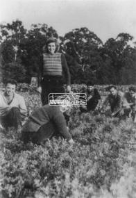
Photograph, At Bell Street; from left: Maurie Fabbro, Myra Skipper, Unknown, Arthur Munday, Ian Robertson. Helen Comprione in front
At Bell Street, Fabbro Farm, Eltham; from left: Maurie Fabbro, Myra Skipper, Unknown, Arthur Munday, Ian Robertson. Helen Comprione in front - probably helping to pick a crop. The site of the Fabbro farm (Diamond Creek side land) is now called Barrack Bushlands. It is doubtful that Fabbro's farm holding was ever called Barrak Park, This title is fairly recent after the Shire of Eltham purchased the land, including the last section in 1993/94. About this time the area on the west side of Falkiner Street was purchased by a private developer and developed as housing. The area in Bell Street opposite the Eltham High School was purchased by the State Government is recent years and is called Fabbro Fields. The Fabbro Family operated their farm in Bell Street, Eltham. 1 black and white photographfabbro's farm, guido fabbro, bell street, arhur munday, eltham, helen comprione, ian robertson, maurice fabbro, myra skipper, picking, farming -
 Eltham District Historical Society Inc
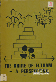
Book, Shire of Eltham, The Shire of Eltham - A Perspective, July 1981
This report was produced by the Shire of Eltham (Planning Department) following a population study of the Shire. It also includes other areas of general interest. The Document contents includes Present and Future - Population - Housing - Residential Lands - Social Characteristics - Development and History. Includes maps, tables and diagrams. Part 1: The Existing situation - introduction, the Shire of Eltham, physical characteristics, historical development, population growth. Characteristics of the population - size and distribution, age / sex, natural increase, migration. Socio-Economic Factors: socio-economic status, employment/workforce, education, other social factors. Housing/ building statistics: characteristics of Housing stock, current residential trends, other types of building activity. Residential Land: existing vacant lots, estimated additional lots. Part 2: The Future. Land availability, the future population.The Shire of Eltham Council resolved on publication of this report "to commend it to the ratepayers as a most valuable resource document". It provides a comprehensive statistical review of the Shire of Eltham, Victoria in 1981 with some population and development predictions for the future.Spiral bound, soft cover, includes indexBarcode and identification markings including stamped "WITHDRAWN" from Heidelberg Regional Library Serviceshire of eltham, planning, population -
 Orbost & District Historical Society
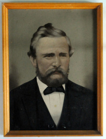
Painting - framed, second half 19th century 1860's?
James came to Australia from Plymouth on the ship "Mobile" arriving 16/11/1853 aged 22. he married Alice Roberts on November 27, 1861. With a large young family he moved from Central Victoria to Glengarry in Gippsland where he farmed and set up sawmills at Glengarry and Rosedale. After hearing of land grants at Orbost and investigating the possibilities with Elizabeth, his eldest daughter he selected land at Pumpkin Point, Bete Bolong. The whole family (ten children from 23years - 2years) eventually moved to Orbost around 1885. ( read "From White Knowle to Pumpkin Point" by Hon Peter Nixon A.O.) He had the first saw mill. He convened the meeting that established butter factory foundation and shares and was the first Agricultural Show president,James Nixon was a significant and influential citizen of Orbost's early years.Portrait done in oils of Nixon, James Mr. The portrait is of the bust of Nixon in a tuxedo with blue to grey background. Timber finish frame.nixon-james orbost-bete-bolong pumpkin-point -
City of Moorabbin Historical Society (Operating the Box Cottage Museum)
Document,leaflet 'Brief History of the City of Moorabbin 1850 - 1934', 2015
2015 CMHS members D. Maynard. Fran & Holger Bader compiled this Leaflet to provide a condensed information Leaflet about the origin and development of the area known as 'The City of Moorabbin' from 1850 -1994. Topics ; Aboriginal Bunurrung people, Henry Dendy's Special Survey 1841 in County of Bourke ; J.B Were, land agent, Pastoralists/ Squatters John O'Shannassy, Richard & John King, Moysey Family, Alexander MacDonald; Parish of Moorabbin Land Developers 1850 J.Holloway, A. Balcombe, D.Wickham, S. Charman, Keys Family; Road District of Moorabbin 1862 - 1870; Shire of Moorabbin 1871 - 1934; City of Moorabbin 1934 - 94; Amalgamation of Councils 1994 divided the City of Moorabbin between the Cities of Glen Eira, Bayside, Kingston and Monash; Origin of suburb names,This Leaflet was compiled in 2015 to provide a condensed history of the area known as 'The City of Moorabbin' for visitors , schools and local community1 x A4 printed both sides, black and white, folded x 3page 1 'BRIEF HISTORY OF THE CITY OF MOORABBIN' ; CITY OF MOORABBIN /1934-1994 page 2 'CITY OF MOORABBIN / 1934 - 94 city of moorabbin, county of bourke, moorabbin roads board, parish of moorabbin, shire of moorabbin, henry dendy's special survey 1841, were j.b.; bent thomas, o'shannassy john, king richard, charman s, highett william, ormond francis, maynard dennis, -
 City of Moorabbin Historical Society (Operating the Box Cottage Museum)
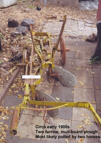
Tool - Farm Machinery, Horse-drawn Furrow Plough, Early 20th Century
Late 1800s-early 1900s A horse-drawn furrow plough is an example of the type of farm implement widely used by pioneer market gardeners in the Moorabbin Shire following 'Dendy's Special Survey' of 1841 and the Crown Land Sale in 1852. Land allotments were bought by pioneer settlers who established or rented allotments for market gardens in the area. They supplied produce to the markets in St Kilda and Melbourne. During the gold-rush of the 1850s the rapidly increasing population of Melbourne saw a huge demand and a rise in prices for all foodstuffs, including the vegetables and fruit grown in the Shire of Moorabbin. This heralded a time of prosperity for market gardeners, and an equally rapid expansion of the numbers of vegetable and produce growers in the area. The 'knock-on effect" resulted in an increased interest and development of the community in the Shire of Moorabbin.Following 'Dendy's Special Survey' of 1841 and the Crown Land Sale in 1852, land allotments were bought by pioneer settlers who established or rented allotments for market gardens in the area and they supplied produce to the markets in St Kilda and Melbourne. During the gold-rush of the 1850s the rapidly increasing population of Melbourne saw a huge demand and a rise in prices for all foodstuffs, including the vegetables and fruit grown in the Shire of Moorabbin. Circa late 1800's to early 1900s. A horse-drawn furrow plough was the most common type of agricultural implement used by the pioneers of the 1800s and continued on into the 1940s when motorised tractors came into use. This plough is an example of a two furrow, mullboard plough which would most likely have been pulled by two horses. The long handle was used to lower the silver plates, (mullboards), to the chosen depth of soil. Painted yellow. Although this Box Cottage museum plough is unbranded, the most widely used plough in the Shire of Moorabbin was made by Oliver. This plough appears to be identical to that brand. brighton, moorabbin, pioneers, fruit, bentleigh, vineyards, vegetables, plough, market gardens, plow -
 Stawell Historical Society Inc
Photograph, Sister Rocks Title Documents c 1867
Photographs of title documents related to the Sister’s Rocks. c 1867. In 1866 a photographer Mr. O.G. Armstrong feared the Sister's Rock's would be used for building material. Mr. Armstrong and Samuel John Davidson squatter of Great Western leased the ground around the Rock's under the 42nd section of then existing "Land Act" enclosing the rocks with a rough fence. Davidson's lease application was dated 30th Jan 1867. The area applied for was 10 acres and issued 2nd July 1867. The fee paid 2 pound 10 shillings annually till July 1871 when an application to purchase was lodged. Two years later the land was transferred to the Borough of Stawell. Photographs also show maps of the areas. Information also includes 3 typed pages copied from the documents photographs. Documents relating to the Sister Rock's c 1867.documents relating to sister's rock's -
 Otway Districts Historical Society
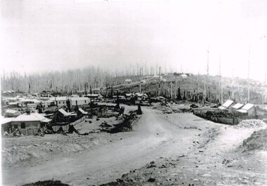
Photograph, Knox Collection, Beech Forest township, c.1903, c.1903
J.W. Gardner erected premises in Beech Forest which formed the core of a village. No further progress was made until access was facilitated though the development of a narrow gauge railway approved by the Victorian Parliament in 1898. Construction commenced in 1900. From this time Colac and Geelong business interests began investment in Beech Forest and established various retail and service establishments over the next few years. In 1902 three early settlers, Gardner, Charles Buchanan and John Cockerill, divided part of their land or bought land which was sold to businesses. On these subdivisions were created saleyards, general stores, a post office, bakery, blacksmithing, banks, a police station and lock-up, a public hall, churches, a state school, bootmaker, butcher, solicitor's office, hairdresser, billiard's saloon and newsagency.B/W. 188mm x 266mm. A general view of Beech Forest township in c.1903.beech forest; township; -
 Kew Historical Society Inc
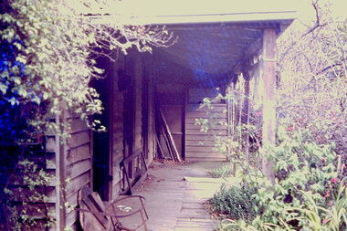
Slide - 'Reno', St John 's Parade, 1977
‘Reno’, stood on the east side of St John’s Parade. Its earliest recorded owner was the architect Samuel Cocking who lived there from c.1865 until his death in 1888. The original landholding was bordered by Cotham Road, Glenferrie Road, Wellington Street, and Charles Street. The southern portion of this land included a fine orchard, with many imported trees. The old summer house, at first in the orchard, was later removed to the house garden. The MMBW Detail Plan No.1576 (1904) shows the remaining portion of the original land holding, including a semi-circular pathway at the front, and garden features such as an aviary, a fountain and grotto, and a fernery. The garden including rare plants supplied by Baron Von Mueller, surrounds the cottage in a tangled frenzy. Despite a ‘local significance’ classification by the National Trust, the house was demolished in 1977.Rare photograph of an historically important weatherboard cottage in St John's Parade.Colour positive transparency (slide) of the verandah of 'Reno' in St John's Parade, Kew (demolished 1977). historic houses -- kew (vic.), reno -- st john's parade -- kew (vic.) -
 Kew Historical Society Inc
Slide - 'Reno', St John 's Parade, 1977
‘Reno’, stood on the east side of St John’s Parade. Its earliest recorded owner was the architect Samuel Cocking who lived there from c.1865 until his death in 1888. The original landholding was bordered by Cotham Road, Glenferrie Road, Wellington Street, and Charles Street. The southern portion of this land included a fine orchard, with many imported trees. The old summer house, at first in the orchard, was later removed to the house garden. The MMBW Detail Plan No.1576 (1904) shows the remaining portion of the original land holding, including a semi-circular pathway at the front, and garden features such as an aviary, a fountain and grotto, and a fernery. The garden including rare plants supplied by Baron Von Mueller, surrounds the cottage in a tangled frenzy. Despite a ‘local significance’ classification by the National Trust, the house was demolished in 1977.Rare photograph of an historically important weatherboard cottage in St John's Parade.Colour positive transparency (slide) of the a doorway of 'Reno' in St John's Parade, Kew (demolished 1977). historic houses -- kew (vic.), reno -- st john's parade -- kew (vic.) -
 Kew Historical Society Inc
Slide - 'Reno', St John 's Parade, 1977
‘Reno’, stood on the east side of St John’s Parade. Its earliest recorded owner was the architect Samuel Cocking who lived there from c.1865 until his death in 1888. The original landholding was bordered by Cotham Road, Glenferrie Road, Wellington Street, and Charles Street. The southern portion of this land included a fine orchard, with many imported trees. The old summer house, at first in the orchard, was later removed to the house garden. The MMBW Detail Plan No.1576 (1904) shows the remaining portion of the original land holding, including a semi-circular pathway at the front, and garden features such as an aviary, a fountain and grotto, and a fernery. The garden including rare plants supplied by Baron Von Mueller, surrounds the cottage in a tangled frenzy. Despite a ‘local significance’ classification by the National Trust, the house was demolished in 1977.Rare photograph of an historically important weatherboard cottage in St John's Parade.Colour positive transparency (slide) of the verandah of 'Reno' in St John's Parade, Kew (demolished 1977). historic houses -- kew (vic.), reno -- st john's parade -- kew (vic.) -
 Kew Historical Society Inc
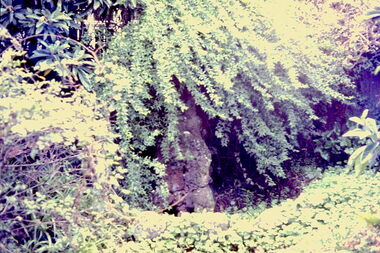
Slide - Grotto of 'Reno', St John 's Parade, 1977
‘Reno’, stood on the east side of St John’s Parade. Its earliest recorded owner was the architect Samuel Cocking who lived there from c.1865 until his death in 1888. The original landholding was bordered by Cotham Road, Glenferrie Road, Wellington Street, and Charles Street. The southern portion of this land included a fine orchard, with many imported trees. The old summer house, at first in the orchard, was later removed to the house garden. The MMBW Detail Plan No.1576 (1904) shows the remaining portion of the original land holding, including a semi-circular pathway at the front, and garden features such as an aviary, a fountain and grotto, and a fernery. The garden including rare plants supplied by Baron Von Mueller, surrounds the cottage in a tangled frenzy. Despite a ‘local significance’ classification by the National Trust, the house was demolished in 1977.Rare photograph of an historically important weatherboard cottage in St John's Parade.Colour positive transparency (slide) of the grotto in the garden of 'Reno' in St John's Parade, Kew (demolished 1977). historic houses -- kew (vic.), reno -- st john's parade -- kew (vic.) -
 Kew Historical Society Inc
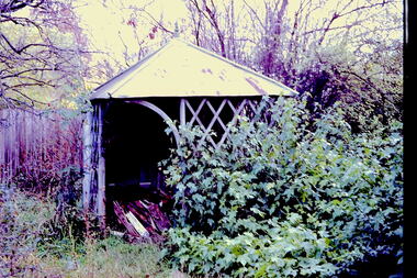
Slide - Former Summerhouse in the Garden of 'Reno', St John 's Parade, 1977
‘Reno’, stood on the east side of St John’s Parade. Its earliest recorded owner was the architect Samuel Cocking who lived there from c.1865 until his death in 1888. The original landholding was bordered by Cotham Road, Glenferrie Road, Wellington Street, and Charles Street. The southern portion of this land included a fine orchard, with many imported trees. The old summer house, at first in the orchard, was later removed to the house garden. The MMBW Detail Plan No.1576 (1904) shows the remaining portion of the original land holding, including a semi-circular pathway at the front, and garden features such as an aviary, a fountain and grotto, and a fernery. The garden including rare plants supplied by Baron Von Mueller, surrounds the cottage in a tangled frenzy. Despite a ‘local significance’ classification by the National Trust, the house was demolished in 1977.Rare photograph of an historically important weatherboard cottage in St John's Parade.Colour positive transparency (slide) of the former summerhouse in the garden of 'Reno' in St John's Parade, Kew (demolished 1977). historic houses -- kew (vic.), reno -- st john's parade -- kew (vic.) -
 Kew Historical Society Inc
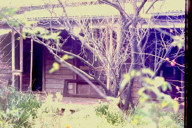
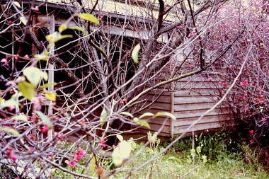
Slide - 'Reno', St John 's Parade, 1977
‘Reno’, stood on the east side of St John’s Parade. Its earliest recorded owner was the architect Samuel Cocking who lived there from c.1865 until his death in 1888. The original landholding was bordered by Cotham Road, Glenferrie Road, Wellington Street, and Charles Street. The southern portion of this land included a fine orchard, with many imported trees. The old summer house, at first in the orchard, was later removed to the house garden. The MMBW Detail Plan No.1576 (1904) shows the remaining portion of the original land holding, including a semi-circular pathway at the front, and garden features such as an aviary, a fountain and grotto, and a fernery. The garden including rare plants supplied by Baron Von Mueller, surrounds the cottage in a tangled frenzy. Despite a ‘local significance’ classification by the National Trust, the house was demolished in 1977.Rare photograph of an historically important weatherboard cottage in St John's Parade.Colour positive transparency (slide) of the garden of 'Reno' in St John's Parade, Kew (demolished 1977). historic houses -- kew (vic.), reno -- st john's parade -- kew (vic.) -
 Kew Historical Society Inc
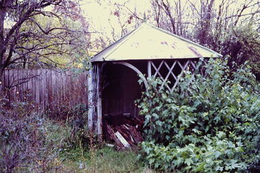
Slide - Former Summerhouse in the Garden of 'Reno', St John 's Parade, 1977
‘Reno’, stood on the east side of St John’s Parade. Its earliest recorded owner was the architect Samuel Cocking who lived there from c.1865 until his death in 1888. The original landholding was bordered by Cotham Road, Glenferrie Road, Wellington Street, and Charles Street. The southern portion of this land included a fine orchard, with many imported trees. The old summer house, at first in the orchard, was later removed to the house garden. The MMBW Detail Plan No.1576 (1904) shows the remaining portion of the original land holding, including a semi-circular pathway at the front, and garden features such as an aviary, a fountain and grotto, and a fernery. The garden including rare plants supplied by Baron Von Mueller, surrounds the cottage in a tangled frenzy. Despite a ‘local significance’ classification by the National Trust, the house was demolished in 1977.Rare photograph of an historically important weatherboard cottage in St John's Parade.Colour positive transparency (slide) of the former summerhouse in the garden of 'Reno' in St John's Parade, Kew (demolished 1977). historic houses -- kew (vic.), reno -- st john's parade -- kew (vic.)