Showing 547 items matching " old post office"
-
 Ballarat Heritage Services
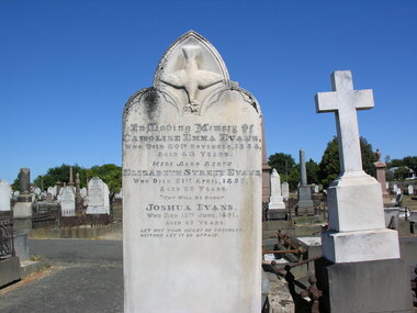
Photograph - Colour, Dorothy Wickham, Grave of Caroline Evans in Ballaarat Old Cemetery, 2006
... Ballarat Heritage Services PO Box 2209 Bakery Hill Post Office goldfields Ballarat Old Cemetery Caroline Emma Evans died 1888 Grave of Caroline Evans in Ballaarat Old Cemetery Photograph - Colour Dorothy Wickham ...Ballarat Old Cemetery Caroline Emma Evans died 1888 -
 Ballarat Heritage Services
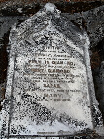
Photograph - Colour, Gravestone, Sarah Diamond, Ballarat Old Cemetery, 1877
... Ballarat Heritage Services PO Box 2209 Bakery Hill Post Office goldfields Ballarat Old Cemetery was officially established in 1856, with a board of trustees. ...Ballarat Old Cemetery was officially established in 1856, with a board of trustees. It had been opened by Ethersay and has burials relating back to 1848. The Rules and Regulations of this historic cemetery are dated 1854, two years prior to its official establishment. Of historic significance are the Eureka Diggers' Graves and the Soldiers Graves associated with Eureka. It is now part of the Ballarat Cemetereis Trust, incorporating the Ballarat Old nad New Cemeteries and the Crematorium.Colour headstone at Ballaarat Old Cemetery.Erected by their loving family an Affectionate Remembrance of their beloved parents, Francis Diamond died 25? Dec 1889 aged 54? years, MARY DIAMOND died 21? March 1887 aged 53? years, natives of Co Derry, Ireland. their beloved daughter Sarah died 18 February 1877 aged 21 years, Mary died 8th Dec 1941diamond, sarah diamond, mary diamond, francis diamond, ballarat, cemetery, ballarat old cemetery, gravestone, burials -
 Ballarat Heritage Services
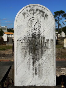
Photograph - Photograph - Colour, Mary Elizabeth Dick, Ballaarat Old Cemetery, 1891
... Ballarat Heritage Services PO Box 2209 Bakery Hill Post Office goldfields Ballaarat Old Cemetery was officially established in 1856, with a board of trustees. ...Ballaarat Old Cemetery was officially established in 1856, with a board of trustees. It had been opened by Ethersay and has burials relating back to 1848. The Rules and Regulations of this historic cemetery are dated 1854, two years prior to its official establishment. Of historic significance are the Eureka Diggers' Graves and the Soldiers Graves associated with Eureka. It is now part of the Ballarat Cemetereis Trust, incorporating the Ballarat Old nad New Cemeteries and the Crematorium.Colour photograph of a gravestone/diamond, sarah diamond, mary diamond, francis diamond, ballarat, cemetery, ballarat old cemetery, gravestone, burials -
 Ballarat Heritage Services
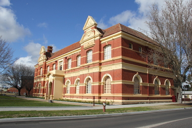
Photograph - Photograph - Colour, Former Maryborough School of Mines, 2011, 06/08/2011
... Ballarat Heritage Services PO Box 2209 Bakery Hill Post Office goldfields The Maryborough School of Mines opened in 1889, with classes held first in the old Town Hall until a new building, financed by local subscription, was constructed in 1890 to a design by the Melbourne architect Phillip Kennedy. maryborough maryborough school of mines Colour photograph of the former Maryborough School of Mines Former Maryborough School of Mines, 2011 Photograph Photograph - Colour Lisa Gervasoni ...The Maryborough School of Mines opened in 1889, with classes held first in the old Town Hall until a new building, financed by local subscription, was constructed in 1890 to a design by the Melbourne architect Phillip Kennedy.Colour photograph of the former Maryborough School of Minesmaryborough, maryborough school of mines -
 Ballarat Heritage Services
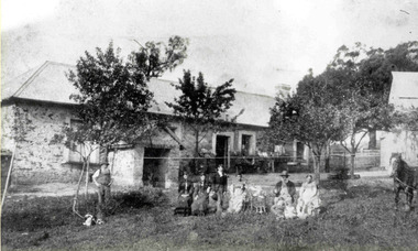
Photograph - Photograph - Black and White, Carlo Gervasoni and Family at Yandoit Creek, c1901
... Ballarat Heritage Services PO Box 2209 Bakery Hill Post Office goldfields luigi gervasoni carlo gervasoni battista nani ambrogio invernizzi stone house drystone julia gervasoni cling gervasoni jim nevin annie gervasoni nichol gervasoni alf kennett bridget gervasoni Carlo Gervasoni and his family stand at the back of his Yandoit Creek house now known as ‘The Old Stone House’. ...Carlo Gervasoni and his family stand at the back of his Yandoit Creek house now known as ‘The Old Stone House’. L to R: Johanna Gervasoni, Annie Gervasoni (Carlo’s second wife), Annie Gervasoni with violin, Jim Neven, Theresa Gervasoni (standing), Nicol Gervasoni with cornet, Bridget Gervasoni, John Gervasoni with cornet, probably Battista Gervasoni, Carlo Gervasoni Jr (Cling) with accordion, Alf Kennett, Julia Gervasoni (standing). The house was built by a partnership between Carlo Gervasoni, Luigi Gervasoni, Antonio Invernizzi and Battista Nani.luigi gervasoni, carlo gervasoni, battista nani, ambrogio invernizzi, stone house, drystone, julia gervasoni, cling gervasoni, jim nevin, annie gervasoni, nichol gervasoni, alf kennett, bridget gervasoni -
 Ballarat Heritage Services
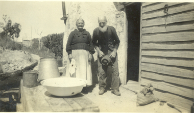
Photograph - Black and White, Old Couple at Dayleford
... Ballarat Heritage Services PO Box 2209 Bakery Hill Post Office goldfields Daylesford elderly An elderly man and woman stand beside their house at Daylesford. Old ...An elderly man and woman stand beside their house at Daylesford.daylesford, elderly -
 Ballarat Heritage Services
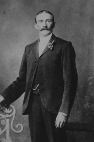
Photograph - Image - Black and White, Ambrogio Invernizzi, c1875, c1875
... Ballarat Heritage Services PO Box 2209 Bakery Hill Post Office goldfields Ambrogio Invernizzi Was from San Giovanni Bianco in Italy, and was an original partner with Carlo Gervasoni, Luigi Gervasoni and Giuseppe Giupponi. They built the 'Old ...Ambrogio Invernizzi Was from San Giovanni Bianco in Italy, and was an original partner with Carlo Gervasoni, Luigi Gervasoni and Giuseppe Giupponi. They built the 'Old Stone House' at Yandoit Creek, that was later lived in by Carlo Gervasoni and his family. Ambrogio and his family living in a neighbouring drystone house. Ambrogio Invernizzi died in 1888, aged 56 years. Ambrogio Invernizzi was born at San Giovanni Bianco, the neighbouring town to San Gallo, the birth town of the Gervasoni Brothers. Photograph portrait of Italian born Ambrogio Invernizzi of Yandoit Creek.ambrogio invernizzi, san giovanni bianco, yandoit creek, swiss italian -
 Ballarat Heritage Services
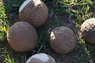
Photograph - Colour, Clare Gervasoni, Wooden bocce balls at Yandoit Creek, 2016, 2016
... Ballarat Heritage Services PO Box 2209 Bakery Hill Post Office goldfields The Gervasoni family made bocce balls from the roots of trees, because the timber was harder. These bocce balls are probably over 100 years old. maurie gervasoni bocce yandoit creek Colour photographs of wooden bocce ball used by the Gervasoni family at Yandoit Creek. ...The Gervasoni family made bocce balls from the roots of trees, because the timber was harder. These bocce balls are probably over 100 years old.Colour photographs of wooden bocce ball used by the Gervasoni family at Yandoit Creek.maurie gervasoni, bocce, yandoit creek -
 Ballarat Heritage Services
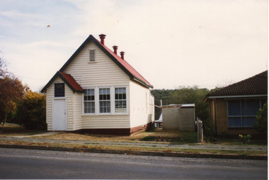
Photograph - Photograph - Colour, Clare Gervasoni, Former Yandoit Hills School 2052 after being moved to Hepburn Springs, c2005, c2005
... Ballarat Heritage Services PO Box 2209 Bakery Hill Post Office goldfields This building was moved from Yandoit Creek to the corner of Main Road and Seventh Street, Hepburn Springs. Yandoit Hills State School No 2052 education Hepburn Springs Yandoit Hills Yandoit Creek Colour photograph of on old schoolhouse that was moved from Yandoit Hills to the corner of Main Road and Seventh Street, Hepburn Springs. ...This building was moved from Yandoit Creek to the corner of Main Road and Seventh Street, Hepburn Springs. Colour photograph of on old schoolhouse that was moved from Yandoit Hills to the corner of Main Road and Seventh Street, Hepburn Springs. The building was used for religious services before being turned into a private residence. yandoit hills state school no 2052, education, hepburn springs, yandoit hills, yandoit creek -
 Ballarat Heritage Services
Photograph - Photograph - Colour, Muskets Firing for Eureka Sunday, 2013, 2013
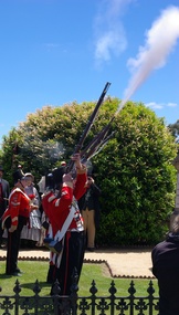
... Ballarat Heritage Services PO Box 2209 Bakery Hill Post Office goldfields eureka sunday 40th regiment muskets ballaarat old cemetery eureka Commemoration British Army Eureka Stockade Colour photograph of re-enactors of the 40th regiment firing muskets at the Soldiers Graves at the Ballaarat Old Cemetery. ...Colour photograph of re-enactors of the 40th regiment firing muskets at the Soldiers Graves at the Ballaarat Old Cemetery. eureka sunday, 40th regiment, muskets, ballaarat old cemetery, eureka commemoration, british army, eureka stockade -
 Ballarat Heritage Services
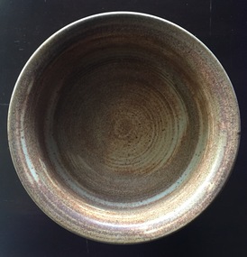
Ceramic - Wheel Thrown Stoneware Bowl
... Ballarat Heritage Services PO Box 2209 Bakery Hill Post Office goldfields Belltower Pottery was established by Rudolf Dybka in Kyabram, Victoria, in around 1977 with the help of John Stroomer. Stroomer later took over the pottery, employing as many as 23 workers and apprentices. After a fire in 1988 destroyed the building, Stroomer moved the pottery to the old ...Belltower Pottery was established by Rudolf Dybka in Kyabram, Victoria, in around 1977 with the help of John Stroomer. Stroomer later took over the pottery, employing as many as 23 workers and apprentices. After a fire in 1988 destroyed the building, Stroomer moved the pottery to the old Kyabram butter factory, where it operated until the late 1990s. Works may be marked with an impressed 'Belltower Pottery' or, after the move to Kyabram, 'Belltower Pottery, Handmade, Kyabram, Vic.'Wheel thrown stoneware bowl with the word 'Nuts' on one side. Stamped "'Belltower Pottery, Handmade, Kyabram, Vic"pottery, belltower pottery, kyabram, australia studio pottery -
 Ballarat Heritage Services
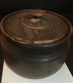
Ceramic - Image, Belltower Pottery, Lidded Wheel Thrown Bowl, c1995
... Ballarat Heritage Services PO Box 2209 Bakery Hill Post Office goldfields Belltower Pottery was set up by Rudolf Dybka in Kyabram, Victoria, in around 1977 with the help of John Stroomer. Stroomer later took over the pottery, employing as many as 23 workers and apprentices. After a fire in 1988 destroyed the building, Stroomer moved the pottery to the old ...Belltower Pottery was set up by Rudolf Dybka in Kyabram, Victoria, in around 1977 with the help of John Stroomer. Stroomer later took over the pottery, employing as many as 23 workers and apprentices. After a fire in 1988 destroyed the building, Stroomer moved the pottery to the old Kyabram butter factory, where it operated until the late 1990s. Works may be marked with an impressed 'Belltower Pottery' or, after the move to Kyabram, 'Belltower Pottery, Handmade, Kyabram, Vic.'Wheel thrown stoneware bowl with the word 'Nuts' on one side. pottery, belltower pottery, rudolf dybka, john stroomer -
 Ballarat Heritage Services
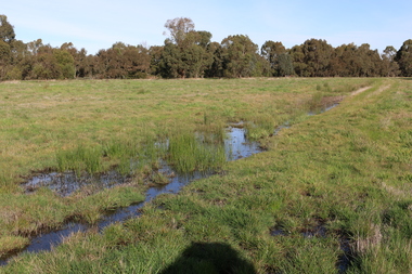
Photograph - Digital photograph, Winter's Swamp surrounds, April 2014
... Post Office goldfields The swamp was named after John (Jock) Winter. John Winter (Jock) was born in Berwickshire, Scotland. He married Janet Margaret Irving the daughter of Robert Irving, advocate, Bonshaw, Dumfries, Scotland. Winter died in Ballarat in 1875 and was buried at the Ballaarat Old ...The swamp was named after John (Jock) Winter. John Winter (Jock) was born in Berwickshire, Scotland. He married Janet Margaret Irving the daughter of Robert Irving, advocate, Bonshaw, Dumfries, Scotland. Winter died in Ballarat in 1875 and was buried at the Ballaarat Old Cemetery. He took up the run Bonshaw from 1841; Leigh River Buninyong 1842-46; Junction, Delatite, March 1851 to September 1862; with sons: Carag Carag and Corop, April 1857 to September 1872; Colbinabbin and Stewart’s Plains, April 1857 to December 1872; St Germains February 1867 to March 1871. (The name became Winter-Irving in 1890). Mr John Winter, who died on August 22 at the age of 72, was a man of some note it the mining community of Ballarat. He was a self-made man, and one of our oldest colonists, it being over a quarter of a century age since he took up county about Ballarat and settled at Bonshaw. He died very rich. It is calculated that if he had retained an interest in all his runs, his income must have been not less than £10,000 or £50,000 a year. Some eight or ten years ago he sold his Bonshaw pre-emption to the Bonshaw Gold mining Company for £20,000, and a few years later the ground belonging now to Winter's Freehold Company brought him £50,000 more, the payment being made at the requisition of the deceased in sovereigns. In these relations Mr. Winter has been closely identified with the mining industry at Ballarat. The deceased was a native of Lauder, in Berwickshire, and landed in Victoria several years before the gold discovery. BHS were commissioned by Ballarat Environment Network for a project on Winter's Swamp and Skipton Common. Winter's Swamp was part of Ballarat West Common. The principle task of this project was the delivery of a report outlining the history of European settlement in the Skipton and Cardigan/Ballarat districts as pertinent to the use of and impact on the natural environment of the two reserves Skipton Common and Winter Swamp. The report was delivered in digital form only. The report, upon completion, was presented to the Network’s Committee in order to discuss the project. The report identified and described the uses of Skipton Common and Winter Swamp, and their impacts. In particular, this report examined farming/grazing (official and informal), mining, vegetation removal (including the removal of woodlands for timber, grasslands for pasture improvement) & use of riparian areas for access to water and timber removal. Recording the more benign and environmentally friendly uses such as picnicking, community activities, nature walks and the roles of organisations such as Field Naturalists’ and Bird Observers’ clubs, school and scout/guide groups will be relevant in helping to depict overall community attitudes towards the reserves; e.g.: has the Common generally been viewed as little more than a grazing paddock and fire hazard; has Winter Swamp always been the unknown natural asset that seems to have been its lot for at least the past 40 years? In this regard, the more contemporary history of actions surrounding the use and management of the reserves is of particular interest, in view of the extant evidence at both reserves; e.g. the actions of the Shire of Ballarat in the 1980s in establishing Winter Swamp as something of a competitor to Lake Wendouree but with a more environmental bent (although almost none of the plants used are indigenous species, but that is part of the story); the trotting track constructed on Skipton Common in the 1960s following representations to Premier Henry Bolte and the cropping of the western section of the Common to raise funds for the town’s new swimming pool, the fertilizing of the land putting an end to the native grassland vegetation. There are obviously multiple sources of information to source in preparing the report, however sources that the contractor is specifically requested to consult are the Skipton Historical Society, the former Skipton Common managers (specifically Graeme Pett), the Cardigan Windermere Landcare Group and the Learmonth Historical Society (believed to hold many of the former Shire of Ballarat’s records pertaining to the Council’s role as the Committee of Management for both Winter Swamp and the Ballarat West Town Common – Winter Swamp was split between 2 separate Crown Land tenures). The contractor is also encouraged but not required to utilise community newsletters, such as the Skipton Community Newsletter, to publicise and seek information about the project. Skipton Historical Society (Mary Bradshaw) contacted on Thursday 12 June 2.30pm. Mary lived on a farm out of Skipton but is currently living in the township. She remembers walking along the creek of the Common especially in spring and autumn in bare feet and that it was a very pretty place. There were a few snakes around the waterway in summer. People put cows and a couple of horses on the commonage to graze. Graeme Pett has always lived close to the Common and would know a lot about it. Other possible contacts would be Nicole Petress, Secretary of the Progress Association, and the Corangamite Council, Camperdown. Mary can’t remember any photos in the Skipton Historical Society that pertain to the Common. Digital photos of Winter's swamp surrounds, later known as Mullawullah.winter, winter's swamp surrounds, winter's swap, john winter, ballarat environmental network, ballarat, mullawullah -
 Ballarat Heritage Services
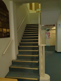
Photograph - Photograph - colour, Clare Gervasoni, Stairway in the Daylesford Hospital, 2019, 22/04/2019
... Ballarat Heritage Services PO Box 2209 Bakery Hill Post Office goldfields Daylesford Hospital was opened in 1862. daylesford hospital Stairwell in the old section of the Daylesford Hospital. ...Daylesford Hospital was opened in 1862.Stairwell in the old section of the Daylesford Hospital.daylesford hospital -
 Ballarat Heritage Services
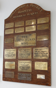
Photograph - colour, Clare Gervasoni, Daylesford and District Hospital Historica Plaques, 2019, 22/04/2019
... Ballarat Heritage Services PO Box 2209 Bakery Hill Post Office goldfields daylesford hospital ernest zelman betty rea elizabeth howe tognini charles tognini w. tognini george monger mervyn monger maurice latimer frederick sands w. angliss j.b. graham a.e. shields thomas orr m.d.woodburn Stairwell in the old section of the Daylesford Hospital. ...Stairwell in the old section of the Daylesford Hospital.daylesford hospital, ernest zelman, betty rea, elizabeth howe tognini, charles tognini, w. tognini, george monger, mervyn monger, maurice latimer, frederick sands, w. angliss, j.b. graham, a.e. shields, thomas orr, m.d.woodburn -
 Ballarat Heritage Services
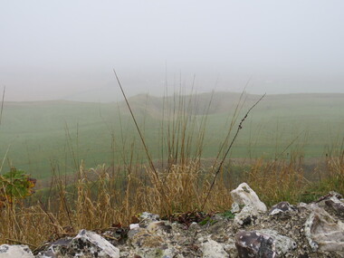
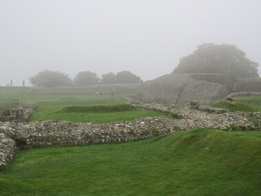
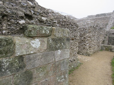
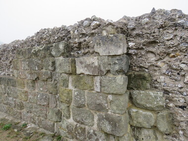
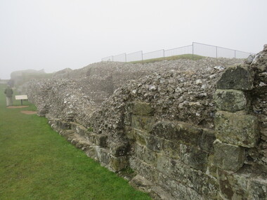
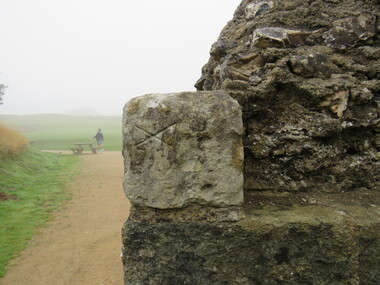
Photograph - Colour, looking from Stonework towards earth mounds, Old Sarum, England, English Heritage Site, 2016, 01 November 2016
... Ballarat Heritage Services PO Box 2209 Bakery Hill Post Office goldfields William the Conqueror inherited Old Sarum from the last Saxon king of England. ...William the Conqueror inherited Old Sarum from the last Saxon king of England. It was an ideal site for a royal castle. It was here in 1070 that William paid off his army after a long and bitter campaign in northern England. It was here in 1086 that he called together all the major landholders in England so they could swear allegiance to him. It was a crucial moment. The Domesday Book was being written, a threatened Viking invasion had only just been averted and William's eldest son was in armed rebellion. Old Sarum was an important place where this Norman king of England held power. In 1794 the Ordnance Survey set out to check the accuracy of the first mapping of Southern England, which had begun ten years earlier. From a point just below Old Sarum Lieutenant William Mudge laid out a base-line 36,574 feet (11,253 metres) long. From each end of the line the positions of distant places were plotted using a huge theodolite made in 1791 by Jesse Ramsden. The accuracy of the process, which was repeated all over England, depended on Jesse Ramsden's craftsmanship and on William Mudge's surveying skill in setting out this first base-line from Old Sarum. The nearer end of Mudge's line is marked by an inscribed stone beside the modern A345 at Old Sarum. ordnance survey, william mudge, jesse ramsden, william the conqueror, old sarum, saxon, 1086, england -
 Ballarat Heritage Services
Photograph - Colour, Looking from Stonework towards people walking on earth mounds, Old Sarum, England, English Heritage Site, 2016, 01 November 2016
... Ballarat Heritage Services PO Box 2209 Bakery Hill Post Office goldfields William the Conqueror inherited Old Sarum from the last Saxon king of England. ...William the Conqueror inherited Old Sarum from the last Saxon king of England. It was an ideal site for a royal castle. It was here in 1070 that William paid off his army after a long and bitter campaign in northern England. It was here in 1086 that he called together all the major landholders in England so they could swear allegiance to him. It was a crucial moment. The Domesday Book was being written, a threatened Viking invasion had only just been averted and William's eldest son was in armed rebellion. Old Sarum was an important place where this Norman king of England held power. In 1794 the Ordnance Survey set out to check the accuracy of the first mapping of Southern England, which had begun ten years earlier. From a point just below Old Sarum Lieutenant William Mudge laid out a base-line 36,574 feet (11,253 metres) long. From each end of the line the positions of distant places were plotted using a huge theodolite made in 1791 by Jesse Ramsden. The accuracy of the process, which was repeated all over England, depended on Jesse Ramsden's craftsmanship and on William Mudge's surveying skill in setting out this first base-line from Old Sarum. The nearer end of Mudge's line is marked by an inscribed stone beside the modern A345 at Old Sarum. ordnance survey, william mudge, jesse ramsden, william the conqueror, old sarum, saxon, 1086, england -
 Ballarat Heritage Services
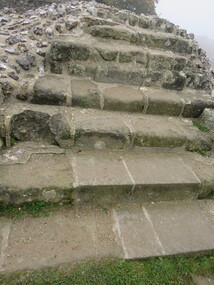
Photograph - Colour, Stairs, Old Sarum, England, English Heritage Site, 2016, 01 November 2016
... Ballarat Heritage Services PO Box 2209 Bakery Hill Post Office goldfields William the Conqueror inherited Old Sarum from the last Saxon king of England. ...William the Conqueror inherited Old Sarum from the last Saxon king of England. It was an ideal site for a royal castle. It was here in 1070 that William paid off his army after a long and bitter campaign in northern England. It was here in 1086 that he called together all the major landholders in England so they could swear allegiance to him. It was a crucial moment. The Domesday Book was being written, a threatened Viking invasion had only just been averted and William's eldest son was in armed rebellion. Old Sarum was an important place where this Norman king of England held power. In 1794 the Ordnance Survey set out to check the accuracy of the first mapping of Southern England, which had begun ten years earlier. From a point just below Old Sarum Lieutenant William Mudge laid out a base-line 36,574 feet (11,253 metres) long. From each end of the line the positions of distant places were plotted using a huge theodolite made in 1791 by Jesse Ramsden. The accuracy of the process, which was repeated all over England, depended on Jesse Ramsden's craftsmanship and on William Mudge's surveying skill in setting out this first base-line from Old Sarum. The nearer end of Mudge's line is marked by an inscribed stone beside the modern A345 at Old Sarum. ordnance survey, william mudge, jesse ramsden, william the conqueror, old sarum, saxon, 1086, england -
 Ballarat Heritage Services
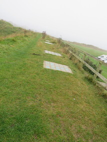
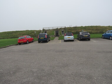
Photograph - Colour, Public toilets hidden in earth mound, Old Sarum, England, English Heritage Site, 2016, 01 November 2016
... Ballarat Heritage Services PO Box 2209 Bakery Hill Post Office goldfields William the Conqueror inherited Old Sarum from the last Saxon king of England. ...William the Conqueror inherited Old Sarum from the last Saxon king of England. It was an ideal site for a royal castle. It was here in 1070 that William paid off his army after a long and bitter campaign in northern England. It was here in 1086 that he called together all the major landholders in England so they could swear allegiance to him. It was a crucial moment. The Domesday Book was being written, a threatened Viking invasion had only just been averted and William's eldest son was in armed rebellion. Old Sarum was an important place where this Norman king of England held power. In 1794 the Ordnance Survey set out to check the accuracy of the first mapping of Southern England, which had begun ten years earlier. From a point just below Old Sarum Lieutenant William Mudge laid out a base-line 36,574 feet (11,253 metres) long. From each end of the line the positions of distant places were plotted using a huge theodolite made in 1791 by Jesse Ramsden. The accuracy of the process, which was repeated all over England, depended on Jesse Ramsden's craftsmanship and on William Mudge's surveying skill in setting out this first base-line from Old Sarum. The nearer end of Mudge's line is marked by an inscribed stone beside the modern A345 at Old Sarum. ordnance survey, william mudge, jesse ramsden, william the conqueror, old sarum, saxon, 1086, england -
 Ballarat Heritage Services
Photograph - Colour, Entrance to Public toilets hidden in earth mound, Old Sarum, England, English Heritage Site, 2016, 01 November 2016
... Ballarat Heritage Services PO Box 2209 Bakery Hill Post Office goldfields William the Conqueror inherited Old Sarum from the last Saxon king of England. ...William the Conqueror inherited Old Sarum from the last Saxon king of England. It was an ideal site for a royal castle. It was here in 1070 that William paid off his army after a long and bitter campaign in northern England. It was here in 1086 that he called together all the major landholders in England so they could swear allegiance to him. It was a crucial moment. The Domesday Book was being written, a threatened Viking invasion had only just been averted and William's eldest son was in armed rebellion. Old Sarum was an important place where this Norman king of England held power. In 1794 the Ordnance Survey set out to check the accuracy of the first mapping of Southern England, which had begun ten years earlier. From a point just below Old Sarum Lieutenant William Mudge laid out a base-line 36,574 feet (11,253 metres) long. From each end of the line the positions of distant places were plotted using a huge theodolite made in 1791 by Jesse Ramsden. The accuracy of the process, which was repeated all over England, depended on Jesse Ramsden's craftsmanship and on William Mudge's surveying skill in setting out this first base-line from Old Sarum. The nearer end of Mudge's line is marked by an inscribed stone beside the modern A345 at Old Sarum. ordnance survey, william mudge, jesse ramsden, william the conqueror, old sarum, saxon, 1086, england -
 Ballarat Heritage Services
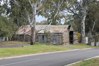
Photograph - Colour, Avoca Shed, 2011, 06/08/2011
... Ballarat Heritage Services PO Box 2209 Bakery Hill Post Office goldfields avoca shed Colour photograph of an old timber shed at Avoca, Victoria. ...Colour photograph of an old timber shed at Avoca, Victoria.avoca, shed -
 Ballarat Heritage Services
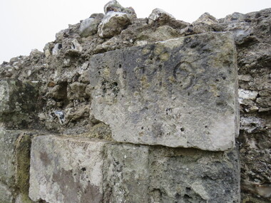
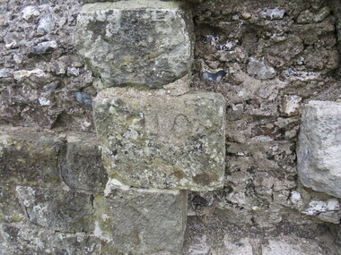
Photograph - Colour, Masons' Marks, Old Sarum, England, English Heritage Site, 2016, 01 November 2016
... Ballarat Heritage Services PO Box 2209 Bakery Hill Post Office goldfields William the Conqueror inherited Old Sarum from the last Saxon king of England. ...William the Conqueror inherited Old Sarum from the last Saxon king of England. It was an ideal site for a royal castle. It was here in 1070 that William paid off his army after a long and bitter campaign in northern England. It was here in 1086 that he called together all the major landholders in England so they could swear allegiance to him. It was a crucial moment. The Domesday Book was being written, a threatened Viking invasion had only just been averted and William's eldest son was in armed rebellion. Old Sarum was an important place where this Norman king of England held power. In 1794 the Ordnance Survey set out to check the accuracy of the first mapping of Southern England, which had begun ten years earlier. From a point just below Old Sarum Lieutenant William Mudge laid out a base-line 36,574 feet (11,253 metres) long. From each end of the line the positions of distant places were plotted using a huge theodolite made in 1791 by Jesse Ramsden. The accuracy of the process, which was repeated all over England, depended on Jesse Ramsden's craftsmanship and on William Mudge's surveying skill in setting out this first base-line from Old Sarum. The nearer end of Mudge's line is marked by an inscribed stone beside the modern A345 at Old Sarum. ordnance survey, william mudge, jesse ramsden, william the conqueror, old sarum, saxon, 1086, england -
 Ballarat Heritage Services
Photograph - Colour, Masons' Marks, Old Sarum, England, English Heritage Site, 01 November 2016
... Ballarat Heritage Services PO Box 2209 Bakery Hill Post Office goldfields William the Conqueror inherited Old Sarum from the last Saxon king of England. ...William the Conqueror inherited Old Sarum from the last Saxon king of England. It was an ideal site for a royal castle. It was here in 1070 that William paid off his army after a long and bitter campaign in northern England. It was here in 1086 that he called together all the major landholders in England so they could swear allegiance to him. It was a crucial moment. The Domesday Book was being written, a threatened Viking invasion had only just been averted and William's eldest son was in armed rebellion. Old Sarum was an important place where this Norman king of England held power. In 1794 the Ordnance Survey set out to check the accuracy of the first mapping of Southern England, which had begun ten years earlier. From a point just below Old Sarum Lieutenant William Mudge laid out a base-line 36,574 feet (11,253 metres) long. From each end of the line the positions of distant places were plotted using a huge theodolite made in 1791 by Jesse Ramsden. The accuracy of the process, which was repeated all over England, depended on Jesse Ramsden's craftsmanship and on William Mudge's surveying skill in setting out this first base-line from Old Sarum. The nearer end of Mudge's line is marked by an inscribed stone beside the modern A345 at Old Sarum. ordnance survey, william mudge, jesse ramsden, william the conqueror, old sarum, saxon, 1086, england -
 Ballarat Heritage Services
Photograph - Colour, Masons' Marks, Old Sarum, England, English Heritage Site, 2016, 01 November 2016
... Ballarat Heritage Services PO Box 2209 Bakery Hill Post Office goldfields William the Conqueror inherited Old Sarum from the last Saxon king of England. ...William the Conqueror inherited Old Sarum from the last Saxon king of England. It was an ideal site for a royal castle. It was here in 1070 that William paid off his army after a long and bitter campaign in northern England. It was here in 1086 that he called together all the major landholders in England so they could swear allegiance to him. It was a crucial moment. The Domesday Book was being written, a threatened Viking invasion had only just been averted and William's eldest son was in armed rebellion. Old Sarum was an important place where this Norman king of England held power. In 1794 the Ordnance Survey set out to check the accuracy of the first mapping of Southern England, which had begun ten years earlier. From a point just below Old Sarum Lieutenant William Mudge laid out a base-line 36,574 feet (11,253 metres) long. From each end of the line the positions of distant places were plotted using a huge theodolite made in 1791 by Jesse Ramsden. The accuracy of the process, which was repeated all over England, depended on Jesse Ramsden's craftsmanship and on William Mudge's surveying skill in setting out this first base-line from Old Sarum. The nearer end of Mudge's line is marked by an inscribed stone beside the modern A345 at Old Sarum. ordnance survey, william mudge, jesse ramsden, william the conqueror, old sarum, saxon, 1086, england -
 Ballarat Heritage Services
Photograph - Colour, Lavendula, Shepherd's Flat
... Ballarat Heritage Services PO Box 2209 Bakery Hill Post Office goldfields shepherd's flat lavendula tinetti lavender Colour photograph of the old drystone Tinetti structure at Shepherd's Flat. ...Colour photograph of the old drystone Tinetti structure at Shepherd's Flat. shepherd's flat, lavendula, tinetti, lavender -
 Ballarat Heritage Services
Photograph - Photograph - Colour, St Brigid's School, Crossley, c1990s
... Ballarat Heritage Services PO Box 2209 Bakery Hill Post Office goldfields Kathleen Carroll visited her old school kathleen gervasoni crossley st brigid's school,crossley education Kathleen (Carroll) Gervasoni stands at her former school, St Brigid's Crossley, Victoria. ...Kathleen Carroll visited her old schoolKathleen (Carroll) Gervasoni stands at her former school, St Brigid's Crossley, Victoria.kathleen gervasoni, crossley, st brigid's school,crossley, education -
 Ballarat Heritage Services
Photograph - digital photographs, Lisa Gervasoni, Daylesford Primary School, c2006-2016
... Ballarat Heritage Services PO Box 2209 Bakery Hill Post Office goldfields Daylesford Primary School, established as a State School in 1875 under Victoria's Education Act, is celebrating its 150th anniversary in 2025, marking a rich history connected to Daylesford's gold rush growth and community development, evolving from earlier private education and sharing links with the Daylesford College. The school occupies historic buildings on Vincent Street, fostering strong community ties through projects like Anzac commemorations, and the Daylesford Museum is hosting exhibitions featuring old ...Daylesford Primary School, established as a State School in 1875 under Victoria's Education Act, is celebrating its 150th anniversary in 2025, marking a rich history connected to Daylesford's gold rush growth and community development, evolving from earlier private education and sharing links with the Daylesford College. The school occupies historic buildings on Vincent Street, fostering strong community ties through projects like Anzac commemorations, and the Daylesford Museum is hosting exhibitions featuring old photos and stories. Colour photograph of a brick building with tower, known as Dayleford Primary School.heritage, daylesford, townscape, primary school, daylesford primary school