Showing 110542 items
matching roads
-
 Glen Eira Historical Society
Album - Album page, Hawthorn Road, Circa 1972
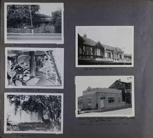
This photograph is part of the Caulfield Historical Album 1972. This album was created in approximately 1972 as part of a project by the Caulfield Historical Society to assist in identifying buildings worthy of preservation. The album is related to a Survey the Caulfield Historical Society developed in collaboration with the National Trust of Australia (Victoria) and Caulfield City Council to identify historic buildings within the City of Caulfield that warranted the protection of a National Trust Classification. Principal photographer thought to be Trevor Hart, member of Caulfield Historical Society. Most photographs were taken between 1966-1972 with a small number of photographs being older and from unknown sources. All photographs are black and white except where stated, with 386 photographs over 198 pages. 17 Hawthorn Road, North Caulfield is a contributory building to HO14 Caulfield North and environs, Caulfield North - Heritage Precinct in the City of Glen Eira.Page 83 of Photograph Album with five portrait photographs of 3 different properties on Hawthorn Road. Addresses are handwritten underneath each property.Handwritten: 17 HAWTHORN ROAD [under top left photo] / 17 HAWTHORN ROAD [under middle left photo] / 17 HAWTHORN ROAD [under bottom left photo] / 158-162 HAWTHORN ROAD [under top right photo] // STATE SAVINGS BANK CAULFIELD WEST BRANCH / 144 HAWTHORN RD / WEST SIDE - SOUTH OFF BALACLAVA ROAD [under bottom right photo] / 83 [bottom left] trevor hart, caulfield, hawthorn road, verandahs, houses, shops, banks, state savings bank, caulfield west, caulfield north, tudor style, victorian style -
 Whitehorse Historical Society Inc.
Photograph, Whitehorse Road, Blackburn, 2012
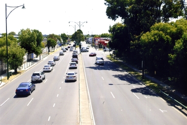
... roads ...Coloured photograph of Whitehorse Road Blackburn looking west, Surrey Road enters Whitehorse Road near the red building on the right - 2012whitehorse road, blackburn, roads, transport -
 Ringwood and District Historical Society
Photograph, Looking south down Warrandyte Road, Ringwood around 1920
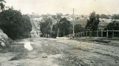
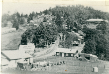
Black and white photograph taken just below where Mullum Mullum Road meets Warrandyte Road.The Mullum Mullum Bridge can be seen in the dip, with numerous houses on the ridge on Whitehorse Road (Maroondah Highway). The fencing was post and rail, with Warrandyte Road unmade, sealed with crushed rocks. -
 Glen Eira Historical Society
Album - Album page, Carnegie Methodist Church, Neerim Road, Circa 1972
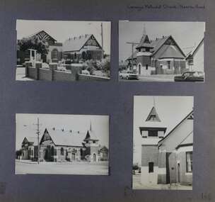
This photograph is part of the Caulfield Historical Album 1972. This album was created in approximately 1972 as part of a project by the Caulfield Historical Society to assist in identifying buildings worthy of preservation. The album is related to a Survey the Caulfield Historical Society developed in collaboration with the National Trust of Australia (Victoria) and Caulfield City Council to identify historic buildings within the City of Caulfield that warranted the protection of a National Trust Classification. Principal photographer thought to be Trevor Hart, member of Caulfield Historical Society. Most photographs were taken between 1966-1972 with a small number of photographs being older and from unknown sources. All photographs are black and white except where stated, with 386 photographs over 198 pages. From Victorian Heritage Database citation for HO47 Uniting Church, 254 Neerim Road https://vhd.heritagecouncil.vic.gov.au/places/42432 (as at 28/10/2020) The former Methodist church (now Uniting church) complex at 252-54 Neerim Road, Carnegie, consists of the original timber church of 1886, the present brick Arts and Crafts influenced church of 1914, designed by A. Phipps Coles, the timber hall attached to the original church, built during the interwar period and the present brick hall of 1933, designed by J.F. Snell. From Victorian Heritage Database citation for HO47 Uniting Church, 254 Neerim Road https://vhd.heritagecouncil.vic.gov.au/places/42432 (as at 28/10/2020) The complex has aesthetic, historical and social significance. Its aesthetic value is derived from the extreme simplicity of the original church and the highly picturesque, eclectic, Arts and Crafts influenced character of the main church and hall. Its historical value rests in the early date of the original building and the manner in which the remaining buildings are representative of the principal period of settlement of the locality. The social significance derives from the use of the site as a place of worship since the commencement of the closer settlement of Carnegie from as early as 1886. Page 146 of Photograph Album with four photographs (3 landscape, 1 portrait) of Carnegie Methodist Church, Neerim Road.Handwritten: Carnegie Methodist Church Neerim Road [top right] / 146 [bottom right]trevor hart, neerim road, carnegie methodist church, church, toolambool road, wesleyan methodist church, breslin gallery, anthony breslin, 1910's, american romanesque, spire, half gabled tower, art, gallery, cafe, arched doorways, red brick, uniting church, carnegie, arts and craft style, a p coles, a coles, j f snell, j snell, halls -
 Geelong Cycling Club
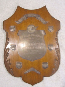
Shield, 1918
Shield awarded to winners of Barnett Glass 25 Mile Road Race 1918. Shield put out by the Barnet Glass Company. After winning the shield for 3 years in a row, the recipient club was awarded the shield. This was the Geelong West Cycling Club.Wooden Shield with nickel plated plaques inscribed with winners names of Geelong Cycling Club 25 mile road race from 1918-1923"BARNETT GLASS SHIELD/ 25 MILES ROAD RACE/FOR CLUBS AFFILIATED/WITH THE/INTER CLUB CYCLING/ASSOCIATIO/FINAL WON BY GEELONG WEST CYCLING/CLUBgeelong cycling club; geelong west cycling club; shield; h.a. boyle; w. costello; f. king; norm hisham; jim holden; s. wells; barnett glass shield; 25 mile road race; 1918; -
 Mt Dandenong & District Historical Society Inc.
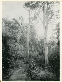
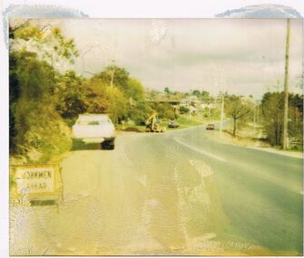
Photograph, Jasper Road Near Erith Lane 1920, 1920
View of Jasper Road, near Erith Lane taken in 1920. The road is tree lined with two significant gum trees in the foreground. This photograph has a detailed inscription on the back handwritten by John Lundy-Clarke in 1974.Jasper Road near Erith Lane 1920. This road has only a narrow right of way. It was put in as a road to serve “Cherry Farm”, connecting it to the Coach Road at the Elbow in 1904. It joins a wide surveyed road running from Inverness Road to the Coach Road at the Elbow and could possibly have been surveyed by Thomas Hand at the same time as Inverness Road. The name Jasper now applies to full length between Erith Lane and Coach Road. McGivern Bros widened it in 1937 and J L Clarke removed and stored much of the rock quarried in the widening. This was later sold to Dick Moorby who sold it to the builders of St Michaels Church in Falls Road. Comment by John Lundy-Clarke 10.5.1974 jasper road, erith lane, john lundy-clarke -
 Mt Dandenong & District Historical Society Inc.
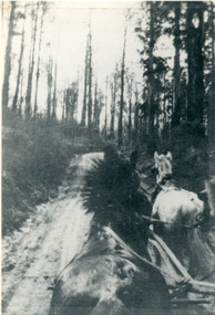
Photograph, View From Seat of Jeeves Coach, c1921
View the driver would have from horse drawn coach. CRB (Main) Road between Wombat Road and Falls Road. c1921. This photograph has a detailed inscription on the back handwritten by John Lundy-Clarke in 1974.View from seat of Jeeves Coach over horses while being driven along the new CRB road between Wombat Road and Falls Rd 1921.wombat road, falls road, crb road, jeeves coach, horse -
 Kew Historical Society Inc
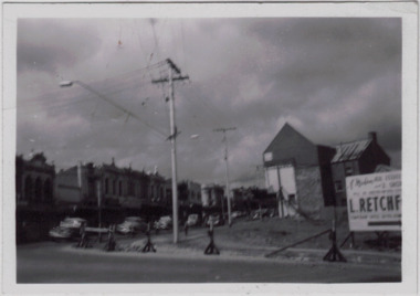
Photograph - Kew Junction during road widening, December 1958
Kew Junction is the intersection of five major roads - Denmark Street, High Street, High Street South, Studley Park Road and Princess Street. The original widening of High Street in the 1930s expanded that street by removing shops on the south side of the street from Cotham Road to Denmark Street. Further widening in 1958 removed shops at the west end of High Street to allow for increased traffic using Princes Street and Denmark Street.Original, black and white positive of Kew Junction, including the corner with Denmark Street during road widening in the 1958.Inscribed verso: "Kew Junction Dec 1958 / When the road was being widened by the removal of a number of shops / Notice saying Retchford's Estate agency's temporary office is at the top end of Denmark Street, Kew"kew junction, denmark street -- kew (vic.), major roadworks -- kew (vic.) -
![Electric tramway construction in Riversdale Road [Surrey Hills]](/media/collectors/550653872162f11fb04854aa/items/661deb37344c8682d4fa54e0/item-media/661dec13344c8682d4fa98bd/item-fit-380x285.jpg) Kew Historical Society Inc
Kew Historical Society IncPhotograph - Electric tramway construction in Riversdale Road [Surrey Hills], E.J. Dower, 1916
Contextual or historic information One of a series of photographs, taken by Edgar James Dower in the second decade of the twentieth century. Born and raised in Olinda, his family later moved to Surrey Hills. He worked as an adult as a clerk in the city office of the Metropolitan Gas Company, and in his role as a 'collector', he was able to photograph scenes including the construction of tramlines and associated buildings in Kew, Hawthorn, Camberwell and Surrey Hills. Later he established a real estate agency with his brother - the E.J. Dower Real Estate Agency, Dandenong Office.The image is an historically significant record of the development of transport infrastructure which was used to connect Victorians in the first two decades of the twentieth century. This development resulted from increases in population and the consequent extension of Melbourne's suburbs. The photographs, both individually and collectively, richly detail the labour of workers and the tools and machinery used to create and extend Melbourne's tram network in the years preceding and during World War 1.Digital copy of an original mounted photograph of construction of the electric tramline in Riversdale Road, Surrey Hills.Annotated verso: "Showing the commencement of preparing for electric trams in Riversdale Road / Taken from the corner of Union Road, note Essex road on right with picket fencing"theme --- travelling by tram, theme -- connecting victorians by transport and communications, trams -- boroondara (vic.), tramlines -- surrey hills -
 Ringwood and District Historical Society
Flyer, Land Sale Advertisement - Strathallyn Estate, Ringwood, Victoria - circa 1950
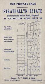
Advertisement for private sale of 36 home sites in the Warrandyte Road and Mullum Mullum Road area of Ringwood, with map showing layout of subdivision and summary of local features and services. Handwritten notation indicates May, 1950.Subdivision includes Warrandyte Road, Strathallyn Road, Norman Court, Lade Court, and Mullum Mullum Road. Agents: A.T. Miles & Son, 175 Main Street, Ringwood, Phone WU6215. -
 Bacchus Marsh & District Historical Society
Map, Tracing of plan shewing portion through Bacchus Marsh District of proposed new Main Road between Gisborne and Blackwood
... Roads ...Road construction and planning was a primary function of the early local government authorities in rural and regional Victoria. This plan is indicative of the sort of documentation which generated considerable public interest and comment in rural communities. The date of this plan is not clear. Newspaper articles in the Bacchus Marsh Express around 1869 contain numerous references to the proposed new road between Gisborne and Blackwood which suggests this plan may date from the late 1860s or early 1870s.A single page paper map showing the proposed route of a main road to be constructed between Gisborne and Blackwood. The map is pasted into a bound volume containing 76 maps or plans in total. High resolution digital image stored on BMDHS computer network. roads, road plans, bacchus marsh victoria maps, gisborne to blackwood main road -
 Kew Historical Society Inc
Photograph - Street Works, Studley Park Road, March 1934
Studley Park Road, like most streets in Kew, was originally a dirt road. Street works during the Great Depression included bituminising major roads in the district. This photograph of Council works originated in the City of Kew Engineers Department as a record of works undertaken. It was given to the collection by a Mrs Fisher in 1998.Well provenanced photograph of Council-funded public works in Kew during the Great Depression. Original sepia monochrome positive of Council workers standing on and beside a dray in Studley Park Road, Kew while resurfacing of the street was taking place. The Kew Junction is just visible behind the men.Typed reverse: "B4 / Kew C.C. / Spreading premixed material on Studley Park Road with drag spreader, view from rear of machine, March 1934"roadworks -- kew (vic.), street works -- kew (vic.), public works kew (vic.), studley park road -- kew (vic.), city of kew -- engineers department, city of kew -- public works -- great depression -- 1930s -
 Whitehorse Historical Society Inc.
Document, James Cowley Morgan Fisher, n.d
Document re James Cowley Morgan Fisher, Thomas Bowen and Charles Carter .Document re James Cowley Morgan Fisher, Thomas Bowen and Charles Carter and land at Dorset & Canterbury Road and LL Road (Boronia Road) and Canterbury Road.Document re James Cowley Morgan Fisher, Thomas Bowen and Charles Carter .fisher, james cowley morgan, bowen, thomas, carter, charles, l l vale road vermont, boronia road, vermont, vermont, dorset road, bayswater, canterbury road, vermont, bayswater -
 Glen Eira Historical Society
Album - Album page, Glen Eira Road, Circa 1972
This photograph is part of the Caulfield Historical Album 1972. This album was created in approximately 1972 as part of a project by the Caulfield Historical Society to assist in identifying buildings worthy of preservation. The album is related to a Survey the Caulfield Historical Society developed in collaboration with the National Trust of Australia (Victoria) and Caulfield City Council to identify historic buildings within the City of Caulfield that warranted the protection of a National Trust Classification. Principal photographer thought to be Trevor Hart, member of Caulfield Historical Society. Most photographs were taken between 1966-1972 with a small number of photographs being older and from unknown sources. All photographs are black and white except where stated, with 386 photographs over 198 pages. From Glen Eira Heritage Management Plan 1996 by Andrew Ward: Since 1990, valuable historic houses to have been demolished include "Noris", later "Quethiock", and "Koala" (1875) at 34 Balaclava Road, "Urandaline", later Samford private hospital at 510 Glen Eira Road, and No. 9 Lempriere Avenue. When the Caulfield Tramway Company opened its single line horse tramway along Glen Eira Road to Caulfield station in 1889, the eastern end of this road passed through open paddocks and alongside "Urandaline", a charming late Victorian villa residence with comer pinnacle roof, demolished in 1995.Page 59 of Photograph Album with five photographs, one portrait of the exterior of a house on Glen Eira Road, the other four are photos of sections of advertising materials for Urandaline Estate.Hand written: 508 Glen Eira Road [under top left photo] / 58 [bottom left] trevor hart, glen eira road, caulfield north, urandaline, urandaline estate, horse tram, land subdivision, real estate advertising, verandahs -
 Mt Dandenong & District Historical Society Inc.
Photograph, Kalorama Gap in 1927, 1927
View of the Kalorama Gap (FiveWays) in 1927. Buildings shown are Jeeves' Garage, FiveWays Cafe, Nicholl's Store, Mountjoy. CRB Main Road, Ridge Road, Old Coach Road and barber's Road also visible. This photograph has a detailed inscription on the back handwritten by John Lundy-Clarke in 1974. The Kalorama Gap in 1927. Showing Jeeves Garage Fiveways Cafe Nicholls Store 'Mountjoy' C.R.B Main Rd Center Ridge Road Right of Center Old Coach Road lower right corner behind shed Barber's Road going left through clump of trees in center kalorama gap, kalorama, fiveways, fiveways cafe, jeeves, jeeves garage, garage, nicholls store, mountjoy, barbers road, old coach road, ridge road, main road, crb road -
 Ringwood and District Historical Society
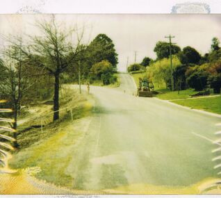
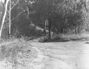
Photograph, Deep Creek Road early 1900s
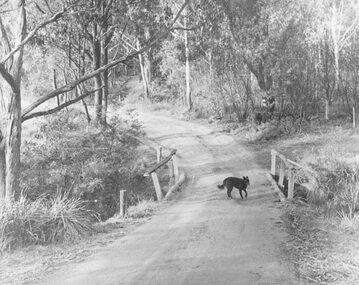
Black and white photograph of bend in unmade road. Bridge with black dog standing on bridge. Forest area on either side of road. (2 copies)Typed below photograph, "Deep Creek Road in early days". -
Whitehorse Historical Society Inc.
Map, Nunawading Shire, 1892
Photocopy of an enlargement of map of Shire of Nunawading showing landowners in 1892.Photocopy of an enlargement of map of Shire of Nunawading showing landowners in 1892. Covers Middleborough Road to Ringwood boundary. One map (Blackburn) from north of Whitehorse Road to Highbury Road, 2nd map (Mitcham) Bulleen to south of Canterbury Road; 3rd map Whitehorse Road to Highbury Road.Photocopy of an enlargement of map of Shire of Nunawading showing landowners in 1892. maps, shire of nunawading, blackburn, blackburn south, nunawading, forest hill, vermont, mitcham, vermont south -
 Halls Gap & Grampians Historical Society
Photograph - B/W, C 1920s
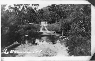
... Roads ...The Wannon Ford - typical of creek crossings in the Grampians.Photo shows a rough, unsealed road running through a ford (the Wannon Ford).access routes, roads -
 Bendigo Historical Society Inc.
Photograph - CASTLEMAINE GAS COMPANY COLLECTION: PHOTO DAYLESFORD, 18/09/1995
... Roads ...Main road Daylesford 18/09/1995Polaroidplace, roads, daylesford -
 Bendigo Historical Society Inc.
Photograph - CASTLEMAINE GAS COMPANY COLLECTION: PHOTO DAYLESFORD, 18/09/1995
... Roads ...Main road Daylesford 18/09/1995Polaroidplace, roads, daylesford -
 Halls Gap & Grampians Historical Society
Photograph - B/W, C 1900
... Roads ...In early 1900, three Emmett brothers, with support from George Mason, set about following up a report of gold in the area. Confirmation of gold led to a gold rush in June 1900. Traffic from Ararat and Willaura passed Mason's Farm and it was on Mason's land that the first settlement, Ladysmith, sprang up.Road leading to Mt William goldfield 1900. George Mason's farmhouse on right hand side of road.access routes, roads, mining, ladysmith -
 Camberwell Historical Society
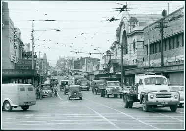
Photograph, Camberwell, Victoria, view of Burke Road and stores, c. 1950
Print of photograph looking north up Burke Road, with Rivoli Cinema on the right. Inscription 'Camberwell, Victoria, view of Burke Road and stores c. 1950' Camberwell, Victoria, view of Burke Road and stores c. 1950camberwell -
 Phillip Island and District Historical Society Inc.
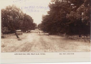
Photograph, Early 20th Century
One of 20 photographs/postcards donated by Mary KarneySepia photograph copy of a postcard. Beach Road, Cowes with fences and trees lining the road."Along Beach Road, Cowes, Phillip Island, Victoria." "Real Photo Series M 1258"beach road, cowes phillip island, cowes phillip island, mary karney -
 Ringwood and District Historical Society
Photograph, Deep Creek Road bridge early 1900s
Black and white photograph taken from unmade road. Road zigzags over bridge with wooden balustrades. Bushland setting. (3 copies)Typed below photograph, "Deep Creek Road bridge in the early days". -
 Southern Sherbrooke Historical Society Inc.
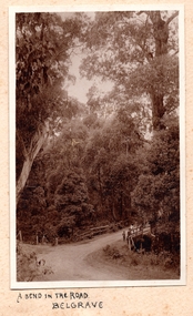
Photograph, A Bend In The Road, Belgrave, c. 1920s
Photo shows a bend in the road, Belgrave, most likely on Monbulk Road below Sherbrooke Forest. An unmade road crosses a small gully. A group of three or so young people are leaning over the bridge railing. The area is heavily treed. A BEND IN THE ROAD hand-wriiten in ink below the photo on the album page -
 Vision Australia
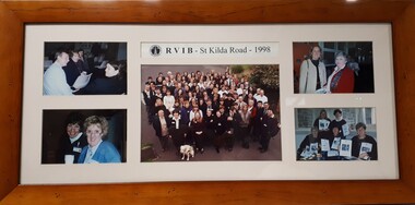
Photograph (item) - Image, Staff at RVIB St Kilda Road - 1998
Five photographs of groups of staff members at RVIB. Image 1 - Maree Littlepage, Christine Harding, ?? Image 2 - ? and Sandie Mackevicius Image 3 - Group photograph in driveway: Blue letters: A - Chris Headland, B - Barbara Williams, C - Ramona Mandy, D - Barbara Royce, E – Tess Rousso, F – Robyn Gale, G – Peter Cronin, H – Chris Edwards, I – Glen Morrow, J – Graeme Craig, K – Barbara McKenzie, L – Marg Harvey, M – Judy Williams, N – Len Stephens, O – Nina Sutton, P – Sherry Cunningham, Q – Marissa Depitta, R – Uli Pfisterer, S – Rosemary, T – Maree Sheehan, U – Linda Rivette, V – Rachel Grealy, W – Fiona Pelusi, X – Maree Littlepage, Y – Danielle, Z – Sophie Tzoukalis. (Between Pelusi and Stephens, Christine Harding. Green letters: A – Emma Rogers-Wilson, B – Rory Fraser, C – Gary Stinchcombe, D – Alex Zolradkovic, E – Nicola Misso, F – Mary Barron, G – Barbara, H – Kathy Lazzaro, I – Linda Morris, J – Pam McAleese. Image 4 - ?? Image 5 - Robyn Gale, ??RVIB - St Kilda Road - 1998royal victorian institute for the blind, staff -
 Lorne Historical Society
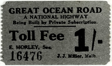
Photograph - Great Ocean Road Toll pass
Tolls were used on the Great Ocean Road from 192 until 19. . Toll gates were at Eastern View and Lorne. Money collected was used to help pay for the construction and maintenance of the road.The Great Ocean Road was built largely by returned serviceman from the First World . The road was built to link the coastal towns, provide better access, to foster tourism and employ the returned servicemen. Fewer private vehicles travelled the road then, most tourists came on coaches and buses. Tourists stayed in guesthouses and hotels. A laminated rectangular , beige , cardboard Great Ocean Road Passenger Service Annual Pass for 1936. Printing is in red lettering with black ink handwritingGreat Ocean Road Passenger Service/Annual Pass/For the year ending November 30th 1936 No 2/Issued to K Quicks Sedan Motors/Subject to compliance with Government Trust Regulations/For Passenger Vehicle Registered No 220529/For the Great Ocean Road Trust PTY LTD/ Date of Issued 3/12/35/ signature unclear/ Secretary/ This pass, which is for Driver and Vehicle only, must be carried by/ Driver, and produced to Toll Gate- keeper on demand, otherwise ordinary / Toll Fees are chargeable.great ocean road, great ocean road tolls -
 Warrnambool and District Historical Society Inc.
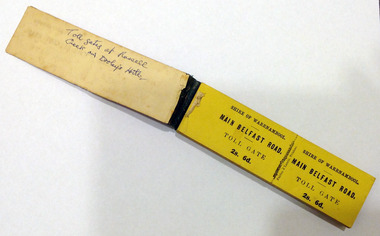
Certificate - Ticket Book, Main Belfast Road Toll, 2s 6d, 1860s
The Shire of Warrnambool operated toll gates from 1866 to 1869 as a means of revenue rai sing for road construction. There were three toll gate locations – on the main Belfast (Port Fairy) Road at Dennington Bridge, on the Woodford Road at Russells Creek and on the Geelong Road at the Allansford Bridge. The toll gates were unpopular and unprofitable for the lessees as travellers were able to avoid the tax by skirting around the gates. They had toll houses besides the gates. The printers of these tickets, Fairfax and Laurie were the lessees at the time of the Warrnambool Examiner newspaper. This paper, founded by Richard Osburne and John Wilkinson, and published with some gaps from 1851 to 1880, is a key source today of Warrnambool’s history at that time. These toll gates tickets are significant because:- 1. They date back to the 1860s and were only issued from 1866 to 1869. 2. They are the only artefacts we hold of the time when toll gates were operating in our local district 3. They are the best example of how the Shire of Warrnambool in its early history raised revenue for road building and maintenance This is a book of toll gate tickets for sale at the Main Belfast (Port Fairy) Road Toll Gate. The tickets (about 50) are yellow and in duplicate with provision to detach the outer ticket for the purchaser to keep. The tickets (two shillings and sixpence) are bound with an adhesive tape and the cover is mottled in pattern (brown and blue). There are also four loose tickets in blue (3 shillings). Back Cover: ‘136’ Tickets in book: ‘Shire of Warrnambool, Main Belfast Road, Toll Gate 2s 6d., Fairfax and Laurie, Printers’ Loose tickets: ‘Shire of Warrnambool, Main Belfast Road, Toll Gate, 3s.’ shire of warrnambool, toll gates -
 Glen Eira Historical Society
Album - Album page, Kambrook Road, Circa 1972
This page of photographs is part of the Caulfield Historical Album 1972. This album was created in approximately 1972 as part of a project by the Caulfield Historical Society to assist in identifying buildings worthy of preservation. The album is related to a Survey the Caulfield Historical Society developed in collaboration with the National Trust of Australia (Victoria) and Caulfield City Council to identify historic buildings within the City of Caulfield that warranted the protection of a National Trust Classification. Principal photographer thought to be Trevor Hart, member of Caulfield Historical Society. Most photographs were taken between 1966-1972 with a small number of photographs being older and from unknown sources. All photographs are black and white except where stated, with 386 photographs over 198 pages. First 2 images: milkbar and residence corner Kambrook and Balaclava Roads ie south west corner - building named Airdrie 3rd image: https://vhd.heritagecouncil.vic.gov.au/places/43737 - re 26 Kambrook Road and 345 Balaclava Road corner building ie south east corner: A prominently situated two-storeyed complex of late Victorian buildings consisting of "Wybar's Buildings" occupying the Balaclava Road/ Kambrook Road corner and the "Caulfield Bakery" facing Kambrook Road, separated by a driveway from a single storeyed shop. The main building has a comer splay and balustraded parapet with curved pediments, the words "Wybar's Buildings 1887" having been obliterated but "Caulfield Bakery 1887" with the characteristic wheatsheaf surviving in raised cement work. The walls are stuccoed and richly ornamented with bracketed cornices and keystones with masks extending to the Bakery. The main building is further distinguished by the Masonic symbol of the mason's dividers in the pediment whilst the upper level of the bakery is in overpainted brickwork. The single storeyed shop incorporates the bracketed cornice and consoles characteristic of the main buildings and is in other respects a utilitarian structure. 4th image: https://vhd.heritagecouncil.vic.gov.au/places/42415 (on 24/01/2021) - 196 Kambrook Road An imposing late Victorian poly-chrome brick asymmetrical villa with corner verandah and projecting west facing wing with faceted window bay to the facade. Body bricks are red and relieved by cream and black brick banding and by cream bricks to the bracketed eaves. The fretted barge with king post treatment and timber posted verandah are unique in the Municipality and unusual in the metropolitan area and demonstrate an understated appreciation of the emerging Queen Anne mode.345 Balaclava and 26 Kambrook Roads HO91 - City of Glen Eira https://vhd.heritagecouncil.vic.gov.au/places/43737 (on 24/01/2021) "Wybar's Buildings" at the corner of Balaclava Road and Kambrook Road are important as a prominent late Victorian commercial development incorporating a variety of activities including a bakery and possibly a coffee palace, the latter understood to be unique within the municipality, but characteristic of the period. It is a rare complex of its type in Caulfield and is important also as evocative evidence of the late Victorian Land Boom and the creation of a small now defunct commercial centre at this location by the George Wybrow. 196 Kambrook Road HO122 - City of Glen Eira https://vhd.heritagecouncil.vic.gov.au/places/42415 "Glencoe" is situated at no. 196 Kambrook Road, Caulfield North and was built for the boot manufacturer, Robert Bruce Mair, in 1888. It is of historic and aesthetic significance. It is historically significant (Criterion A) as the home of an inner suburban industrialist, notable a boot manufacturer, demonstrating the attraction of Caulfield as a residential location for the manufacturers of the metropolis during the late Victorian Boom period. It is aesthetically significant (Criterion E) as a very early example of a Queen Anne influenced late Victorian villa, comparing at the State level with ''Woodlands'' (1888), North Essendon, generally acknowledged to be one of Australia's earliest houses to fully exploit this emerging style. The ornamental timberwork is especially expressive of the new architectural fashion and compares with the house at 33 Clarence Street, Elsternwick (1888-89).Page 105 of Photograph Album with two photographs of a milk bar and attached residence, one older photograph of Wybar's Building and another photograph of a house on Kambrook Road (all are landscape).Handwritten: 196 KAMBROOK ROAD / 1970 - GAFFNEY MRS S.M. [under bottom right photo] / 100 [bottom left]trevor hart, kambrook road, victorian style, caulfield north, parapets, wybar's buildings 1887, caulfield bakery 1887, architectural features, painted bricks, balaclava road, george wybrow, shops, milk bars, airdrie, polychrome bricks, verandahs, queen anne architectural style, houses, glencoe, robert mair -
 Kew Historical Society Inc
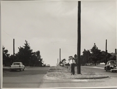
Photograph, Stuart Tompkins Studio, Electricity Supply Poles, Burke Road, Kew, 1965
Research provided by Stuart Tompkins Studio, Box Hill, into alternatives for median strip street lighting to be used in Burke Road, Kew. The photographers identified variants in different suburbs appropriate to Kew's needs.The series from which the photograph is drawn provides a snapshot by a commercial photographic studio of each named vicinity in 1965 as well as providing examples of public works infrastructure being commissioned by local government in the 1960s. The photos originally formed part of the Engineering Department's files in the City of Kew before being donated to the kew Historical Society.Electricity Supply Poles, Burke Road, Kew, 1965. This photograph of Burke Road, Kew was taken just north of Kilby and Doncaster Roads looking north. Stuart Tompkins Studio provided the photograph for the Kew City Council. In the photograph are a number of electricity supply poles that have been erected in the median strip, in addition to some new poles on each footpath. The nearest wooden pole is stated to be 13.5″ in diameter. The electricity poles in Burke Road required Kew Council to investigate comparable designs in other Melbourne municipalities. [There are three copies of this photograph in the Collection.] Typed inscription on reverse: "Electricity Supply Poles. Photographed for Kew City Council 8/2/65. No.5 Burke Road - Kew, just north of Kilby and Doncaster Roads looking north. Some of seven poles already erected in median strip. Shows also some new poles erected on each footpath. Nearest wooden pole 13 1/2" dia." Studio stamp: "Stuart Tompkins Studio. 547 Station Street, Box Hill. WX1439."stuart tompkins studio, street lighting, south road (moorabin) 1965