Showing 593 items
matching underground.
-
 Bendigo Historical Society Inc.
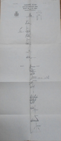
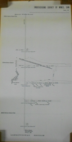
Map - UNITED HUSTLER'S & REDAN & K. K. MINES - PLAN OF UNITED HUSTLER'S & REDAN & K. K. MINES
Plan of the United Hustler's & Redan & K. K. Mines on the Hustler's Line of Reefs Bulletin No 33 Plate No XXVII. Plan shows depth of levels, Long Gully, Hustler's Line of Reefs, Lightning Hill Line of Reefs and approximate Boundary of Lease. Also mentions Comet Co. Geological Survey of Victoria emblem and signed by H S Whitelaw, Underground Survey Office Bendigo September 1913.mining, parish map, united hustler's & redan & k. k. mines, long gully, hustler's line of reefs, lightning hill line of reefs, comet co, h s whitelaw, geological survey of victoria, underground survey office -
 Bendigo Historical Society Inc.
Map - FORTUNA HUSTLER'S MINE - TRANSVERSE SECTION OF THE FORTUNA HUSTLER'S MINE
Transverse Section of the Fortuna Hustler's Mine on the Hustler's Line of Reef, Bendigo. Bulletin No 33, Plate No III. Drawing shows poppet legs on the surface and Sill of Shaft 745.38 feet above Sea Level. Shows levels and their depths, geographical features and stone encountered. Reference table to stone and geographical features. Geographical Survey of Victoria emblem. Signed by H A Whitelaw, Underground Survey Office, Bendigo. mining, fortuna hustler's mine, hustler's line of reef, geological survey of victoria, underground survey office bendigo, h a whitelaw -
 Bendigo Historical Society Inc.
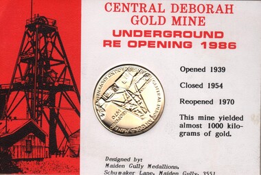
Medal - MICHELSEN COLLECTION: MEDALLION CENTRAL DEBORAH MINE REOPENING 1970
Medallion in housed in cardboard folder. at the front Central Deborah Gold Mine underground reopening 1986. Opened:1939, Closed: 1954, Reopened: 1970. this mine yielded almost 1000 kilograms of gold. Designed by; Maiden Gully Medallions, schumaker Lane, Maiden Gully, 3551. On the reverse: talking tram tour Bendigo Australia with pictures of the Post Office, Alexandra Fountain and souvenir tram ticket. The folder is in a brown envelopenumismatics, medals - commemorative, deborah mine reopening -
 Bendigo Historical Society Inc.
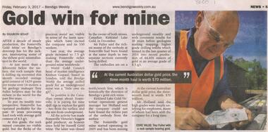
Newspaper - FOSTERVILLE GOLD MINE COLLECTION: ARTICLE 'GOLD WIN FOR MINE'
Newspaper article, Friday 3, 2017, Bendigo Weekly. titled 'Gold win for mine' by Sharon Kemp. Fosterville Gold Mine has hit the jackpot intercepting some of the richest gold mineralisation in the world. Article describes richness of Fosterville deposit. Fosterville started operating in 2005 and has been mining underground for 10 years. 'At the current Australian dollar gold price, the three month haul is worth $70 million'bendigo, mining, fosterville gold mine -
 Bendigo Historical Society Inc.
Document - MINING REPORTS - LINE OF REEF AT YANKEE CREEK NEAR BENDIGO
BHS CollectionTyped photocopy of a letter dated September 19th, 1898 from W. H. Cundy, Underground Survey Office, Bendigo. Letter refers to a locality, eight miles due east from Bendigo, and five miles west from Hunt's line of Reef Ellesmere. The writer did not think there was any necessity for a special survey to define the position of the reef. Handwritten at the bottom of the letter: for Report by Whitelaw See Progress Report No 10.document, gold, mining reports, mining reports, line of reef at yankee creek near bendigo, underground survey office bendigo, c tillach, koch's pioneer battery, mr grieve, hallidays claim, w h cundy, whitelaw -
 Melbourne Tram Museum
Pamphlet, Metropolitan Transport Committee, "MTC - Melbourne Prospect - Australia's First Road-Rail Complex", 1972?
Folded gloss full colour sheet to quarto size, pamphlet titled "MTC - Melbourne Prospect - Australia's First Road-Rail Complex", the Doncaster - Eastern Freeway. Front cover article reports on the construction of the freeway which will later have a railway to Doncaster. Reports also on flexibility of the MTC (Metropolitan Transport Committee) planning for transport, new suburban trains (Silver), the Underground loop, flyovers at Richmond Station and freeways in general.trams, tramways, melbourne, traffic control, transportation, doncaster, railways, mtc, metropolitan transport committee -
 Bendigo Historical Society Inc.
Map - LANSELL'S BIG 180 MINE - LOCALITY OF LANSELL'S NO 180 SHAFT
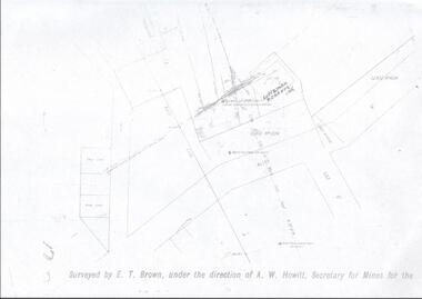
Buff coloured photocopy of the location of Lansell's No 180 Shaft and showing the positions of Underground Workings near the intersection of Lily St and Alley St. Also mentioned are the North Old Chum Shaft and the New Chum and Victoria Co Shaft. Luffman Brothers has been written in in pen and initialled A R. Printed at the bottom is: Surveyed by E. T. Brown, under the direction of A. W. Howitt, Secretary for Mines for the - (the rest is cut off).map, bendigo, mining plan, lansell's big 180 mine, locality of lansell's no 180 shaft, north old chum co shaft, new chum and victoria co shaft, luffman brothers, e t brown, a w howitt -
 Bendigo Historical Society Inc.
Map - HUSTLER'S REEF NO 1 MINE - EAST & WEST CROSS-CUTS OF THE HUSTLER'S REEF NO 1 MINE
Map showing the East & West Crosscuts, North & South of Shaft of the Hustler's Reef No 1 Mine on the Hustler's Line of Reefs Bulletin No 33, Plate No XXII. Drawing shows where the different levels are, the stone encountered and smaller drawings of other sections near the shaft. Also shows some geographical features. Signed by H A Whitelaw, Underground Survey Office Bendigo, September 1913. Geological Survey of Victoria emblem.mining, parish map, hustler's reef no 1 mine, geological survey of victoria, h a whitelaw, underground survey office bendigo, hustler's line of reefs -
 Bendigo Historical Society Inc.
Map - HUSTLER'S REEF & HUSTLER'S REEF NO 1 MINES - PLAN OF THE HUSTLER'S REEF & HUSTLER'S REEF NO 1 MINES
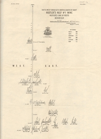
Plan of the Hustler's Reef & Hustler's Reef No 1 Mines on the Hustler's Line of Reefs, Bendigo Bulletin No 33, Plate No XVI. Plan shows the two shafts and the levels in relation to it. No 9 Level 896 feet 9 inches connecting No 10 Level at 867 feet 2 inches. Plan shows depth of levels and geographical features. Signed by H A Whitelaw, Underground Survey Office, Bendigo. Geographical Survey of Victoria emblem.mining, parish map, hustler's reef & hustler's reef no 1 mines, hustler's line of reefs, h a whitelaw, underground survey office bendigo, geographical survey of victoria -
 Bendigo Historical Society Inc.
Map - HUSTLER'S ROYAL RESERVE NO 2 MINE - PLAN OF THE HUSTLER'S ROYAL RESERVE NO 2 MINE
Plan of the Hustler's Royal Reserve No 2 Mine on the Hustler's Line of Reefs Bulletin No 33, Plate No VI. Boundary of Leases No 8898 and 8897 shown. Various levels shown and some geographical features. Geological Survey of Victoria emblem. H . Harman, Director, W. Dickson, Secretary for Mines and The Hon. J. Drysdale Brown, Minister of Mines and signed by H Whitdon, Underground Survey Office, Bendigo, September 1913. mining, parish map, hustler's royal reserve no 2 mine, hustler's line of reefs, geological survey of victoria, h herman, w dickson, the hon j drysdale brown mlc -
 Bendigo Historical Society Inc.
Map - UNITED HUSTLER'S & REDAN MINE - TRANSVERSE SECTION UNITED HUSTLER'S & REDAN MINE
Transverse Section of the United Hustler's & Redan Mine on the Hustler's Line of Reefs Bulletin No 33, Plate No XXIX. Map has drawing of poppet legs on the surface, depth of levels, type of stone encountered and some geological features. Sill of shaft 745.62 ft above sea level. Map has Geological Survey of Victoria emblem and signed by H S Whitelaw, Underground Survey Office Bendigo, 'September 1913. mining, parish map, united hustler's & redan mine, hustler's line of reef, geological survey of victoria, h s whitelaw -
 Bendigo Historical Society Inc.
Map - UNDERGROUND SECTION OF 3 MINES
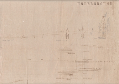
Underground section of three mines - Shaft No 94, New Chum United Co, Cross Section No 89 - Shaft No 93, Lansell's 222 (DENIS), Cross Section No 87 - Shaft No 92A (New Shaft), Lansell's 222, Cross Section No 86. Map shows depth of cross sections below the sill and stone encountered. Poppet legs are drawn at the top of the shafts. Lansell's 222 Shaft No 92A has measurements penciled in.mining, parish map, new chum united, lansell's 222 -
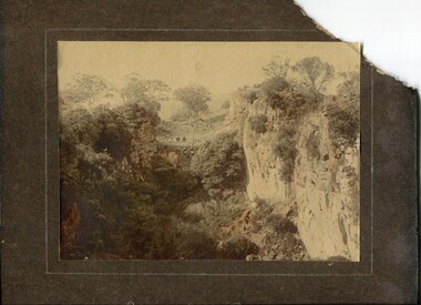 Orbost & District Historical Society
coloured photograph
There is no information with this item. "The Pyramids", was named due to huge rocks that jut out from the hill, being shaped similarly to the Egyptian Pyramids. " Where the Murrindal River winds between high limestone bluffs before disappearing into a mountainside and becoming an underground river, four miles north-east of Buchan, is the region known as The Pyramids. It is an area of limestone caverns and sink holes overshadowed by three rock stacks. Some of the caves are the last resting places of long dead Murrindal animals." ( from MBW Walk magazine 1970 - Melbourne Bushwalkers"A hand-painted colour photograph of a view of mountain ranges with men on horses in the background.on front - "Pyramid Gorge Buchan"pyramid-gorge-buchan murrindal limestone-caves -
 Wangaratta RSL Sub Branch
Photograph, c1941
The famous Tobruk Fig Tree was named because it marked the entrance to a network of underground caves used to treat wounded soldiers. It became known as the Fig Tree Hospital. The caves became a place where wounded soldiers could be stabilized before being transferred to the Australian General Hospital. The Fig Tree was the only feature in an otherwise barren desert and an easy target for German artillery who heavily shelled the site for several hours per day. A cutting from the tree was brought back to Australia and planted at Melbourne's Shrine of Remembrance.The 2/24th Battalion was an infantry battalion of the Australian Army, which served during World War II .A unit of all-volunteers, it was formed in July 1940 from primarily Victorian volunteers and was known as "Wangaratta's Own" because of the time the battalion spent in the town during its formative period prior to deployment overseas. It served in North Africa in 1941–1942 as part of the 26th Brigade, which was assigned to the 7th Division, before being reassigned to the 9th Division. In early 1943, the battalion returned to Australia and later took part in campaigns against the Japanese in New Guinea in 1943–1944 and Borneo in 1945, before being disbanded in 1946. The 2/24th suffered the highest number of casualties of any 2nd AIF infantry battalion. The Unit was granted the Freedom of the City by the Rural City of Wangaratta in 1996 and one of the first, if not the first, to receive this type of honour. Reproduced black and white photograph of four soldiers under large tree - one soldier in dugout under tree watching two stretcher bearers carry out wounded soldierHandwritten on rear - Fig Tree Tobruk 2/24th battalion, fig tree, tobruk -
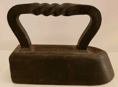 Wodonga & District Historical Society Inc
Functional object - CARRON brand Tailor's "Goose" Iron With Twist Handle, Carron Iron Company, c1850s - 1900
THE CARRON COMPANY The Carron Company established its ironworks on the banks of the River Carron in Falkirk, Stirlingshire, Scotland, in 1759, and became an incorporated company in 1773. The company was the largest ironworks in Europe during the 19th century. It supplied ammunition and armaments, steamboat engines, pig iron, cast iron goods such as flat irons, balustrades, fire grates and bath tubs, pillar boxes and telephone boxes, and even cast iron rings for underground tunnels. In 1982 it became insolvent and was taken over by the Franke Corporation, using the brand Carron Phoenix.This iron is representative of the domestic appliances used throughout Australia up until electricity became widely available for domestic use.An antique Carron iron made of solid cast iron. These types of iron were nicknamed "sad irons" from the Old English where "sad" was originally a word which meant "heavy and solid". Typically, there would be two irons simultaneously in use: one to iron with and one being heated up on the stove or in the fire. This iron has a flat bottom and back and it curves to a point at the front. It has a goose neck handle which has a twist. Irons such as this were often given the name "goose" irons. Near the front of the iron on its top '11' is marked. These irons were used from the late 18th to mid 20th centuries before electricity was widely available in all areas, particularly in rural environments.On top of iron "CARRON"flat irons, domestic appliances -
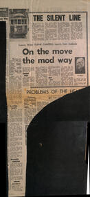 Melbourne Tram Museum
Newspaper, Herald Sun, "The Silent Line", 18-8-1969
Reports on a Science Congress in Adelaide and a speech by Robert Risson about future transport possible systems - all types such as conveyor belts, air cushion vehicles, magnetic cushions, pneumatic tubes, moving footpaths, jet-propelled vehicles, gas turbine and diesel electric buses. These are known as "gadgetbahns" mooted proposals that seldom come to commercial fruition. His main emphasis was on the future all-electric tram fleet that was proposed for Melbourne. Also notes underground systems such as San Francisco. Item by Science Writer Frank Campbell.Yields information about possible future transport systems - gadgetbahnsNewspaper clipping - "The Silent line" and "On the move the mod way" - The Herald "18-8-1969" tramways, trams, melbourne, public transport, future transport, transport systems, electric trams, all-electric trams, robert risson, gadgetbahns, underground tramways -
 Federation University Historical Collection
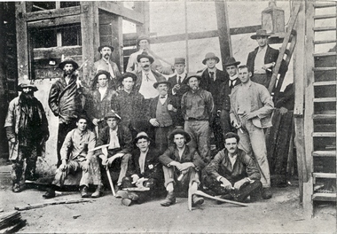
Photograph (black & white), Ballarat School of Mines Students visit the New Normanby Mine, 1899, 1899
In 1875 John Rowe enrolled at the Ballarat School of Mines (SMB) where he studied Metallurgy and Assaying. In 1880 the Britannia Mine closed and John Rowe moved to Launceston working as Manager of the Royal Tasman Gold Mining Company. He returned to Ballarat two years later to manage the Long Gully United Gold Mining Company. In 1885 John Rowe sought work in New Caledonia followed by South Africa. While in South Africa he received an offer from SMB to lecture in Practical Mining, an instructional innovation which involved weekly visits to some of the principle mines in the district. John Rowe took up this position in 1994, but it appears to have been a short lived innovation ending in 1996, possibly due to John Rowe's failing health. (http://guerin.ballarat.edu.au/curator/honour-roll/honourroll_Rowe,John.shtml)Nineteen men, some Ballarat School of Mines students, pose outside Ballarat's New Normanby Mine. Some hold picks and candles. The man in the centre wearing a waistcoat is John Rowe, experienced miner and lecturer in Practical Mining at the Ballarat School of Mines. The June 1899 Ballarat School of Mines Magazine records: "The mining class visited the Britannia Gold Mine, and were kindly shown over the surface and underground workings by Mr. Harvey."candle, ballarat school of mines, safety cage, john rowe, new normanby gold mine, mining alumni, pick -
 Bendigo Historical Society Inc.
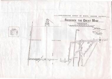
Map - STRUGNELL COLLECTION: UNDERGROUND SURVEY OF MINES, BENDIGO DISTRICT, 7-1-99
Map, Underground Survey of Mines Bendigo District.Frederick the Great Mine, Sebastian. A collection of nine (9) maps of the mine, Signed H.S.Whitelaw Field Geologist 4.1.99 with some notes relating to same, including a: * Typed overview of the operation of the mine in 1912. * Clipping from Victoria its Mines and Minerals detailing the operation of the mine from its beginning in 1863 where it was first worked for alluvial. Charlton & Co., and Mr. Glass mentioned in article.A.S.Whitelawmap, bendigo, frederick the great mine -
 Bendigo Historical Society Inc.
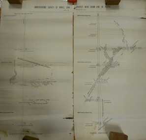
Document - MARKS COLLECTION: UNDERGROUND SURVEY OF MINES NEW CHUM LINE OF REEFS
Plan, in two sections, on heavy parchment coloured paper. Printed across top in black ink 'Underground Survey of Mines New Chum Line of Reefs' a. Shows cross section of mine, b. longitudinal section. Drawn by Arthur Everett, Mining Department, Melbourne 1884. Surveyed by Caleb Thomas under the direction of Charles Langtree. Plan found in George Lansell auction items. Plan found in George Lansell items sold at auction.bendigo, mining, new chum reef -
 Bendigo Historical Society Inc.
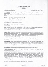
Document - LANSELL'S BIG 180 MINE - CONDENSED HISTORICAL RECORD OF LANSELL'S BIG 180 MINE
Two handwritten and three typed copies of a Condensed Historical Record of Lansell's Big 180 Mine on the New Chum Line of Reef. Notes include location, shaft, first worked, size of lease, plant, engine house, boiler rooms, mullock heap, early history, Prominent, best gold, underground connections, pressurised hot water, diamond drill bores and a table with depths and the increase in temperature with the depth (in Fahr). Albert Richardson Collection. document, gold, lansell's big 180 mine, lansell's big 180 mine, condensed historical record of lansell's big 180 mine, wittscheibe, ballerstadt, ernst mueller, theodore ballerstadt, george lansell, north old chum, victoria quartz, mines dept special edition 'australian mining standard' 1/6/1899, mines dept booklet 'bendigo goldfield' 1936, quarterly reports, lansell's 180 mine 'transverse sections, annals of bendigo mining sections, a richardson's observations from old photographs and measurements of mining plans, measurements taked from caleb thomas' report mines dept 1875, 'report on observation of underground temperature at bendigo' james stirling government geologist 1899, a richardson -
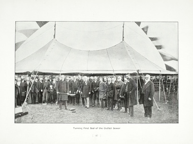 Melbourne Water
Photograph - Turning Of The First Sod, 1908
The 19th of May marks the anniversary of the turning of the first sod of the outfall sewer. In 1888, a Royal Commission into Melbourne’s public health led to an ambitious plan to construct a sewerage system of underground pipes, sewers and drains to carry sewage from homes and factories to a sewage treatment farm. The commission also supported the establishment of the Melbourne Metropolitan Board of Works (MMBW), the authority that would build the sewerage system and manage Melbourne’s water supply. This photograph is from The Melbourne and Metropolitan Board of Works Water Supply, Sewerage, and etc Photographic Views, 1908This photograph is in excellent condition and provides a detailed insight into Board personnel of the MMBW. It is of historical importance to the history of Melbourne in the turning of the very first sod.Black and white photographphotograph, mmbw, melbourne metropolitan board of works, melbourne water, historic, turniing of the first sod, book, sewerage, water -
 Bendigo Historical Society Inc.
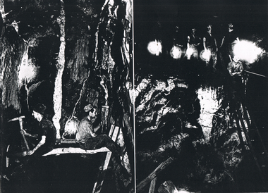
Photograph - LONG GULLY HISTORY GROUP COLLECTION: TWO UNDERGROUND PHOTOS
Copies of two dark black and white photos of underground mining at the Hercules mine. The left side one shows two miners facing the sides of the shaft prior to the boxing in with red gum slabs. one man is using a sledge hammer and the other is using a hand pick. The right-hand side photo This photo was either the Shenandoah or the New Chum Railway. Five men standing on a higher part are holding lamps and one man is standing on a ladder.bendigo, history, long gully history group, the long gully history group - two underground photos, hercules, shenandoah, new chum railway, victoria quartz -
 Bendigo Historical Society Inc.
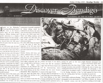
Newspaper - LONG GULLY HISTORY GROUP COLLECTION: FLOODING OF THE VICTORIA QUARTZ
Copy of an article from the Bendigo Weekly 19/5/2000 Discover Bendigo - Flooding of the Victoria Quartz by James Lerk. Article mentions the flooding of the mine, the equipment left in there and where the water had come from. An accompanying photo, taken by Vincent Kelly, shows miners at work underground. John Ennor, the mine manager at the time and William Abraham, the Mining Inspector are in the photo. Written on the photo is: 4156 ft below Vic Quartz G Mine.bendigo, history, long gully history group, the long gully history group - flooding of the victoria quartz, bendigo weekly 19/5/2000, james lerk, william abraham, matthew stevens, 180 mine, new chum and victoria, new chum railway, new shenandoah, new chum reef, south bellevue, nell gwynne reef, new chum drainage association, bendigo advertiser, vincent kelly, john ennor -
 Bendigo Historical Society Inc.
Administrative record - Mining Wages Book
John S Wearne First Manager of the Specimen Hill Co. W.H. Thomas Manager from September 1873. OBITUARY. Residents of the Borough of Eaglehawk will regret to learn of the death of Mr. John Wearne, a former well-known member of that community. The late Mr. Wearne, who was 68 years of age, came to Victoria in 1857. He was the first manager of the Specimen Hill mine and was also largely interested in several other mines in the district. Some considerable time ago he retired from active pursuits, and went to reside at Strathfieldsaye, whence he removed to Ascot Vale some years ago, where he lived until his death, his remains were brought to Eaglehawk by the mid-day train yesterday and conveyed to the family vault in the Eaglehawk Cemetery, many friends joining the cortege. Six members of the family survive — two sons and four daughters — Mrs. Wearne having pre-deceased her husband some time ago. OBITUARY. Article - Bendigo Advertiser (Vic. : 1855 - 1918)Saturday 22 September 1906 - Page 5 Mining Company Pay book for a mining company. Dated from January 7, 1871 - February 12, 1876. Ledger format with six Columns - Name, Occupation. No. of Days, Rate, Amount, Signature on Receipt of Wages. First page lists J.S. Wearne as Manager, C. Palmer as Underground Manager, Miners - Rodda, Johns, Wearne, Kneebone, Trengove, Duncalf, Tresize. The ledger is in very poor condition and has been used by a child for drawing and writing practice.wages, mining, specimen hill mine -
 Bendigo Historical Society Inc.
Document - MARKS COLLECTION: NEW CHUM LINE OF REEF MAP
Plan (copy) of New Chum Line of Reef. Plan has been copied in two sections. On top of plan 'Underground survey of mines Sandhurst, New Chum Line of Reef', plan shows longitudinal and cross section views of the workings on the reef. Shaft No. 76 marked. Datum line on top indicates 750' above sea level, on bottom of plan, bottom of shaft 2022.24 below sill. Drawn by Arthur Everett, Mining Department, Melbourne, 1884.bendigo, mining, new chum line of reef -
 Bendigo Historical Society Inc.
Document - CENTRAL NELL GWYNNE - HISTORY OF THE CENTRAL NELL GWYNNE
2 copies of typed notes on the history, underground workings, production, mining costs, machinery and equipment, structural features and present and future development. Written by J. J. Caldwell, Field Geologist. Dated 6th October, 1938. 1st copy images 3509.4a,4b,4c,4d,4e,4f,4g,4h 2nd copy images 3509.4i,4j,4k,4l,4m,4n,4o,4p,4q,4r,4s,4t,4u,4vJ. J. Caldwellmine, gold, central nell gwynne, central nell gwynne, history of the central nell gwynne, j. j. caldwell -
 Bendigo Historical Society Inc.
Map - K. K. MINE - TRANSVERSE SECTION K. K. MINE
Transverse Section of the K. K. Mine on the Hustler's Line of Reefs, Bulletin No 33, Plate No XXXII. Map shows the different levels and their depth. Also, the different types of stone encountered and geological features such as spurs and faults. Has drawing of the poppet legs at the top of the shaft and sill of shaft 773.56 ft above sea level. Map has Geological Survey of Victoria crest and signed by H S Whitelaw, Underground Survey Office Bendigo, September 1913. miners, fortuna hustler's mine, transverse section of k. k. mine, hustler's line of reefs, geological survey of victoria, h s whitelaw -
 Bendigo Historical Society Inc.
Map - HUSTLER'S REEF MINE - EAST & WEST CROSS-CUTS, NORTH & SOUTH OF SHAFT
East & West Crosscuts, North & South of Shaft, Hustler's Reef Mine Bulletin No 33, Plate No XIX. Map shows main shaft and smaller drawing of section with different stone encountered. Also gives location in relation to the shaft, e. g. 225'E & 150'S of Shaft. Reference diagram to show the different stone and features encountered. Geological Survey of Victoria emblem. Signed by H A Whitelaw, Underground Survey Office Bendigo, September 1913. mining, parish map, hustler's reef mine, east & west cross-cuts north & south of shaft, geological survey of victoria, h a whitelaw, underground survey office bendigo -
 Kiewa Valley Historical Society
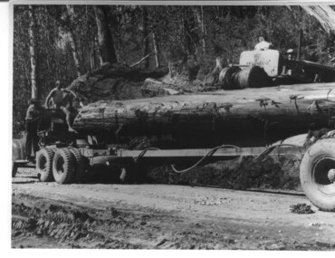
Photograph, logging at McKay Creek, Logging at McKay Creek, 1949/50
This photo was most likely taken at the site of the proposed McKay Creek Power Station. Excavation of this site was commenced in 1951 but an access road (a rough, narrow track) was put it in 1948 and widened in 1954. The State Electricity Commission would have milled logs from this area at their mill at Howman's Gap. The timber was used for building of housing and camps and provided a much needed resource as there was a general shortage of this commodity. The power station was relocated underground owing to repeated problems with landslides in the area. Restricted financial resources and the repositioning of the power station retarded construction activities and it was not completed until early 1961. An historical pictorial record of the type of machinery used in the 1950's - logging truck with bogie attached, the bull dozer and winch for hauling logs to the truck and note the lack of protective clothing!Black and white photograph showing a logging truck, bogie and bull dozer with winch for hauling the logs to the truck. Two men are on the truck, a driver on the bull dozer and a large log on the bogie. Hand written on the back of photo "Logging at McKay Creek".logging, mckay creek, timber, machinery -
 Otway Districts Historical Society
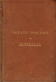
Book, Government Printer, Potato diseases in Australia, 1911
Potatoes are known for their great liability to disease, suffering more from the ravages of fungi than any other crop, and this is largely owing to the fact that they are propagated from tubers which are just swollen portions of underground branches of the stem. Portions of the parent plant in the form of tubers or cuttings are planted year after year, so that any inherent weakness in the original is transmitted to the offspring, and therefore, without a process of selection, deterioration is sure to occur sooner or later. When the tubers are raised from seed and a good selection made from them, they are less liable to disease at least for a number of years. Handbook of fungus diseases of the potato in Australia and their treatment. D. McAlpine. 1st ed. Department of Agriculture, Victoria; Melbourne (Vic); 1911. x, 314 p.; illus., map. Hard cover.potatoes; disease; fungus; agriculture;