Showing 693 items
matching 250
-
 University of Melbourne, Burnley Campus Archives
Plan, Royal Children's Hospital, 1989-1991
(1) Landscape Concept Royal Children's Hospital by Bates Smart and McCutcheon. (2) Tracing paper Sketch Plan. Scale 1:250 dated 29.3.90 by Jill Kellow. (3) Garden Project, The Foundation Royal Children's Hospital by Denise L. Stephens, DLS Design. Sheet 6 of 7, May 1990. Scale 1:100. (4) Photocopy of Surfaces and Playground Equipment, Royal Children's Hospital, August 1991. No 9046/01. Scale 1:100. (5) Photocopy of Surfaces and Playground Equipment, Royal Children's Hospital, August 1991. No 9046/02. Drawn By R.K. Scale 1:100.royal children's hospital, bates smart, jill kellow -
 Federation University Historical Collection
Book, Final recommendations Ballarat Study Area Land Conservation Council, Victoria, 1982, 1982
Yellow soft covered report of 95 pages . The contents of the report include: Parks, reference areas, wildlife reserves, water production, harwood production, softwood production, flora Reserves and Flora and Fauna reserves, bushland reserves, historic area and reserves, rivers and streams, Roadside conservation and Highway parks, Education areas and School Plantations, Lake Reserves, geological reserves, recreation, scenic reserves, agriculture, mineral and stone production, utilities and survey, township land, Uncommitted Land, military training, other reserves and public land. Maps include: The Study area 1: 250 000 Supplementary Mapsland conservation authority, ballarat, endowment plantations, pine plantations, langi ghiran state park, mount buangor state park, enfield state park, ballarat-creswick regional park, rossbridge, black lake, flax mill swamp, dereel lagoon, lake bolac, lake wongan, langi ghiran reservoir, gong gong reservoir, pincotts reservoir, beales reservoir, wilsons reservoir, moorabool reservoir, korweinguboora, korweinguborra reservoir, learmonth bores, sago hill, illabarook reservoir, ballarat water commission, dunneworthy, mount cole, mont lonarch, ben major, waterloo, trawalla, linton, ross creek, canadian, shepherds flat, lal lal, mount doran, raglan, chute, carngham, buninyong, watsons hill, enfield, cape clear, illabrook, rokewood junction, mount warrenheip, nerrina, jubilee, golden stream, australasian deep lead mine, happy valley school, piggoreet, berringa, bulldog, ballarat common, wildlife, water, timber, flora, rivers, geology, agriculture, warrenheip, biodiversity -
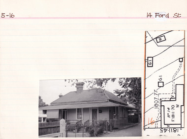 The Beechworth Burke Museum Research Collection
Card (Series) - Index Card, George Tibbits, 14 Ford Street, Beechworth, 1976
George Tibbits, University of Melbourne. Faculty of Architecture, Building and Town & Regional PlanningIndex system that support the research for Beechworth : historical reconstruction / [by] George Tibbits ... [et al]Arranged by street names of BeechworthEach index card includes: street name and number of property, image of property, allotment and section number, property owners and dates of ownership, description of the property according to rate records, property floor plan with dimensions.beechworth, george tibbitsbeechworth, george tibbits -
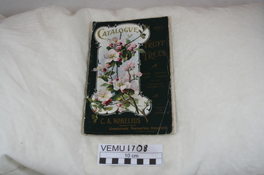 Emerald Museum & Nobelius Heritage Park
Book, Catalogue of Fruit Trees 1915 C.A. Nobelius Nurseryman, Gembrook Nurseries, Emerald, Victoria, Australia, 1915
This is the twenty fourth catalogue of trees and it contains fruit trees, nut trees, berries and some ornamental trees. Carl Nobelius wrote in his General Remarks that he had one million trees to sell, clean, healthy and pest free. The nurseries were 250 acres in extent and contained two and a half million trees in various stages. His nurseries were at Emerald, Railway Siding and his office half a mile from Emerald Railway Station. He imported new varieties from overseas and the nursery was the largest in the Southern Hemisphere, employing 80 people between 1903 and 1930.Green Catalogue 1915 of Fruit Trees, also Elms, Oaks, Planes, Poplars and other Deciduous and Ornamental Trees. The catalogue contains 5 black and white prints of landscape views of the nursery, plus there are 5 bright colour inserts of individual pears and apples.nobelius -
 Melbourne Tram Museum
Newspaper - Newspaper clipping, The Age Newspaper, "Trams CEO on a track to lift service", 01/07/2023
Interview with Yarra Trams CEO, Carla Purcell. Appointed to CEO role by Yarra Trams owner Kelli's Downer in November 2022, but started in April 2023 after returning from maternity leave. Tender process is underway for next tram franchise, currently worth $500M per year. Yarra Trams have operated the network for 13 years with current contract expiring at end of 2024. Tram patronage currently at 75% of pre-Covid levels. Melbourne's tram network currently consists of 475 trams, 250 km of track, 2300 employees servicing 200M annual passengers.Informative interview with Carla Purcell, CEO of Yarra TramsNewspaper clipping from the Age titled: "Trams CEO on a track to lift service"tramways, ceo, yarra trams, keolis downer-edi, tender documents, trams -
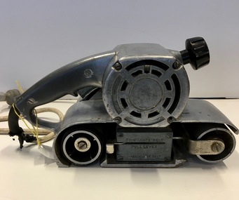 Federation University Historical Collection
Tool - Electrical Instrument, Electric Belt Sander, c1960s
Used in Building Studies at Ballarat School of Mines. The sander used to sand rough timber smooth, remove old finish from wood, put a bevel on a door, reduce the thickness of timber, dress up a poor saw cut. Also used for back cutting miter cuts for neater joints and for polishing and cutting.Stainless steel with rollers and sanding plate. Hand held. Continuous loop of sandpaper would be mounted.Maker's Plate: MILLER FALL TOOLS CATALOG 830 3 INCH BELT SANDER MODEM "C" USE 3" X 21" BELT 230/250 VOLTS 3 AMPS 25-60 CYCLES MADE IN USA PATENT 2,991,595 MILLER FALLS COMPANY, GREEFIELDS, MASS. TO CHANGE BELT PULL LEVER DIRECTION OF BELT ballarat school of mines, building studies, david flintoff, timber, smooth, miter cuts, polishing, buffing, thinning -
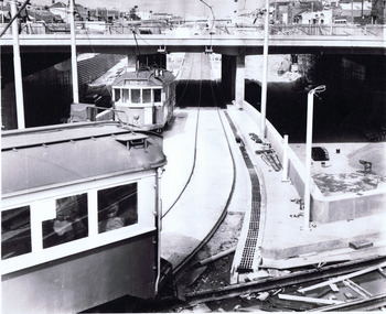 St Kilda Historical Society
Photograph, Wellington St bypass, c. 1968
picture shows ramp from St Kilda Road to by-pass road filed 22.10.68black and white photographAge photo V18369 (titled 22.10.68). Trams using Wellington St by-pass for first time. Picture shows ramp from St Kilda Rd to by-pass road. Copyright. This photo may not be reproduced without permission in writing from the editorof "The Age". 250 Spencer Street, Melbourne and 39/41 York Street, Sydney. -
![Straus’ Falls, Cape Otway Ranges / [by] Nicholas Caire, circa 1876](/media/collectors/550653872162f11fb04854aa/items/57833e2ad0cdd1176c6791eb/item-media/57833ea7d0cdd1176c67b9d8/item-fit-380x285.jpg) Kew Historical Society Inc
Kew Historical Society IncPhotograph, Anglo-Australasian Photographic Company, Straus’ Falls, Cape Otway Ranges, c. 1876
Nicholas Caire was born on Guernsey in the Channel Islands in 1837. He arrived in Adelaide with his parents in about 1860. In 1867, following photographic journeys in Gippsland, he opened a studio in Adelaide. From 1870 to 1876 he lived and worked in Talbot in Central Victoria. In 1876 he purchased T. F. Chuck's studios in the Royal Arcade Melbourne. In 1885, following the introduction of dry plate photography, he began a series of landscape series, which were commercially successful. As a photographer, he travelled extensively through Victoria, photographing places few of his contemporaries had previously seen. He died in 1918. Reference: Jack Cato, 'Caire, Nicholas John (1837–1918)', Australian Dictionary of Biography.An original, rare photograph from the series 'Views of Victoria: General Series' by the photographer, Nicholas Caire (1837-1918). The 60 photographs that comprise the series were issued c. 1876 and reinforced a neo-Romantic view of the Australian landscape to which a growing nationalist movement would respond. Nicholas Caire was active as a photographer in Australia from 1858 until his death in 1918. His vision of the Australian bush and pioneer life had a counterpart in the works of Henry Lawson and other nationalist poets, authors and painters.‘Straus’ Falls, Cape Otway Ranges’ : Views of Victoria (General Series) No.55 : Albumen silver photograph | Photo on card with Title and Description on reverse | Mounted 24 x 30 cm; Photo 12 x 17 cm.On Reverse: ‘These Falls were discovered some time since by a gentleman named Straus, and were so named in memory of him. They comprise a succession of falls, rapids, and cataracts varying from 10 feet to 60 feet, making a total of 250 feet from the fall to the bed of the stream. These waters probably form a tributary to one of the adjacent rivers.’nicholas caire (1837-1918), landscape photography -
 Eltham District Historical Society Inc
Photograph - Aerial Photograph, Landata, Eltham North, Feb. 1956
Centred on present day 54 Kelway Crescent, Eltham North bounded by Glen Gully Road to north, Meruka Drive to south, Eltham College to east and Leach Street to west. Historic Aerial Imagery Source: Landata.vic.gov.au Aerial Photo Details: Project No :250 Project : MELBOURNE OUTER SUBURBS PROJECT Run : 17 Frame : 113 Date : 02/1956 Film Type : B/W Camera : EAG9 Flying Height : 10000 Scale : 12000 Film Number : 1176 GDA2020 : 37°42'16"S, 145°08'08"E MGA2020 : 335650, 5825336 (55) Melways : 21 G2 (ed. 42)aerial photo, 1956-02, eltham, eltham north, glen gully road, leach street, main road, melway 21g2, meruka drive, montmorency, neil webster collection -
 Eltham District Historical Society Inc
Photograph - Aerial Photograph, Landata, Montmorency, Feb. 1956
Centred on present day Tahlee Place Reserve and Sherbourne Preschool, Montmorency bounded by Progress Road to north, Withers Way to south, Main Road to east and Leach Street to west. Historic Aerial Imagery Source: Landata.vic.gov.au Aerial Photo Details: Project No :250 Project : MELBOURNE OUTER SUBURBS PROJECT Run : 17 Frame : 114 Date : 02/1956 Film Type : B/W Camera : EAG9 Flying Height : 10000 Scale : 12000 Film Number : 1176 GDA2020 : 37°42'50"S, 145°08'02"E MGA2020 : 335512, 5824286 (55) Melways : 21 F5 (ed. 42)aerial photo, 1956-02, neil webster collection, central park, eltham, leach street, main road, melway 21f5, montmorency, progress road, withers way, sherbourne preschool, tahlee place reserve -
 Eltham District Historical Society Inc
Photograph - Aerial Photograph, Landata, Lower Plenty, Feb. 1956
Centred on present day 217 Old Eltham Road, Lower Plenty bounded by Pitt Street to north, Yarra River to south, Main Road to east and Bonds Road to west. Historic Aerial Imagery Source: Landata.vic.gov.au Aerial Photo Details: Project No :250 Project : MELBOURNE OUTER SUBURBS PROJECT Run : 17 Frame : 116 Date : 02/1956 Film Type : B/W Camera : EAG9 Flying Height : 10000 Scale : 12000 Film Number : 1176 GDA2020 : 37°43'58"S, 145°07'49"E MGA2020 : 335237, 5822186 (55) Melways : 21 E10 (ed. 42)aerial photo, 1956-02, neil webster collection, eltham, main road, bonds road, elham, lower plenty, melway 21e10, pitt street, yarra river -
 Eltham District Historical Society Inc
Photograph - Aerial Photograph, Landata, Eltham, Feb. 1956
Centred on present day Shalbury Avenue, Eltham bounded by Leane Drive and Parsons Road to north, Nyora Road to south, Reynolds Road to east and the Diamond Creek to west Historic Aerial Imagery Source: Landata.vic.gov.au Aerial Photo Details: Project No :250 Project : MELBOURNE OUTER SUBURBS PROJECT Run : 18 Frame : 95 Date : 02/1956 Film Type : B/W Camera : EAG9 Flying Height : 10000 Scale : 12000 Film Number : 1176 GDA2020 : 37°41'57"S, 145°09'51"E MGA2020 : 338145, 5825965 (55) Melways : 22 C1 (ed. 42)aerial photo, 1956-02, neil webster collection, eltham, diamond creek (creek), melway 22c1, nyora road, parsons road, reynolds road, shalbury avenue -
 Eltham District Historical Society Inc
Photograph - Aerial Photograph, Landata, Research, Vic, Feb. 1956
Centred on present day Thompson Crescent, Research bounded by Maroondah Aqueduct to north, Thompson Crescent and Nyora Road to south, Bells Hill Road to east and Eucalyptus Road to west Historic Aerial Imagery Source: Landata.vic.gov.au Aerial Photo Details: Project No :250 Project : MELBOURNE OUTER SUBURBS PROJECT Run : 19 Frame : 6 Date : 02/1956 Film Type : B/W Camera : EAG9 Flying Height : 10000 Scale : 12000 Film Number : 1176 GDA2020 : 37°42'38"S, 145°11'02"E MGA2020 : 339927, 5824736 (55) Melways : 22 H4 (ed. 42)aerial photo, 1956-02, neil webster collection, bells hill road, eltham, eucalyptus road, maroondah aqueduct, melway 22h4, nyora road, research (vic.), thompson crescent -
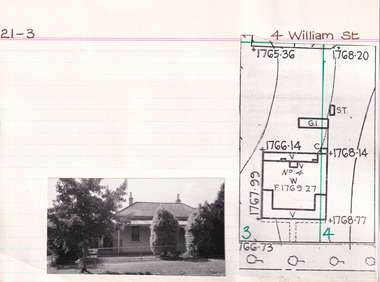 The Beechworth Burke Museum Research Collection
Card (Series) - Index Card, George Tibbits, 4 William Street, Beechworth, 1976
George Tibbits, University of Melbourne. Faculty of Architecture, Building and Town & Regional PlanningIndex system that support the research for Beechworth : historical reconstruction / [by] George Tibbits ... [et al]Arranged by street names of BeechworthEach index card includes: street name and number of property, image of property, allotment and section number, property owners and dates of ownership, description of the property according to rate records, property floor plan with dimensions.beechworth, george tibbitsbeechworth, george tibbits -
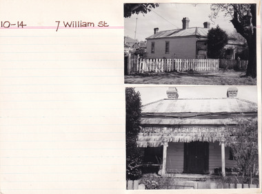 The Beechworth Burke Museum Research Collection
Card - Index Card, George Tibbits, 7 William St, Beechworth, 1976
Property - 7 William Street Beechworth, Section 10, Town Allotment 14, 100 x 250 Ownership details and history - 11 Apr 1856 - W.C. Hill 1857 F.J. Doull 1862 F.J. Doull, Land 33' x 165', Prem 21' x 13' x'9" / Prem 20' x 13'9" (occupier R. Nelson) 1866 - Land 33 x 165 Prem 20' x 13'9" slabs & bark, £7.10.0 1870 - T Dalziel - Land Only 66x165 1883 - Land Only Architectural Index Card - Brian Pump and Tony Dugan - Photographers beechworth, george tibbits -
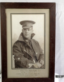 Bendigo Military Museum
Photograph - PORTRAIT WW1, FRAMED, Post WW1
Thomas William Francis No 2584. Enlisted on 7.7.1915 in 4th reinforcements 29th Batt AIF age 25 years 6 months. Embarked for Eygpt 14.3.16, embark for France 16.6.1916, reported missing 19/20.7.1916, listed as KIA 20.7.16 (Fromelles) no known grave. The photo is one of a number that originally hung in the "Gallery of Honour" foyer of the Soldiers Memorial Institute Pall Mall Bendigo now the Bendigo Military Museum. In 2008 a mass grave was found with 250 remains in. On 12.4.2013 it was announced that the remains of Thomas Francis had been identified. Francis is now buried in the new Pheasant Wood Military Cemetery. Refer Cat No 8003.Portrait photo B &W of a soldier in uniform, Great coat and peak hat re T.W Francis. Photo is set in a grey background with a dark stained wood frame."Pte T.W Francis 29th Batt D Coy A.I.F, enlisted July 1915, embarked March 1916. Killed in Action July 1916". brsl, smirsl, fromelles -
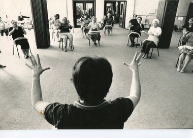 Melbourne Legacy
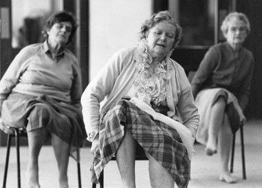
Photograph - Exercise Classes, Widows activities, 1988
A photo of ladies doing light exercises at Legacy House with the instructor Betty Luders. From 1928 until the 1990s, Melbourne Legacy ran an excellent exercise program for its widows. Classes were held weekly at Legacy House and there was often a waiting list for the water classes, which had both swimming instruction and water exercises. Some of the class members were in their 90s, many just learning to swim.A record of activities provided for Legacy widows.Black and white photo of several older women sitting on chairs in a semi-circle, doing some light exercises. The back of the instructor's head can be seen in the foreground.Stamped on the back: "COPYRIGHT / This photograph many not be / produced without permission / in writing from the / Pictoral Dept. of "The Age" / 250 Spencer Street, Melbourne / Victoria, 3001", "Jul 15 3 29 AM '88" Taped to the back: " NEIL NEWITT 15/7/88 E.G. / SENIOR CITIZENS (WOMEN ONLY) AT / "AEROBICS" AT LEGACY HOUSE. / STORY: DAVID BRUCE"widows, exercise classes, activities, betty luders -
 Melbourne Legacy
Photograph - Exercise Classes, Widows activities, 1988
Ladies doing light exercises on chairs at Legacy House. From 1928 until the 1980s, Melbourne Legacy ran an excellent exercise program for its widows. Classes were held weekly at Legacy House and there was often a waiting list for the water classes, which had both swimming instruction and water exercises. Some of the class members were in their 90s, many just learning to swim.A record of activities provided for Legacy widows.Black and white photo of three older women sitting in chairs doing light exercises.Stamped on the back: "Jul 15 3 29 AM '88", "COPYRIGHT / This photograph may not be / reproduced with permission / in writing from the / Pictoral Dept. of "The Age" / 250 Spencer Street, Melbourne, / Victoria, 3001, Australia" Taped to the back: "NEIL NEWITT 15/7/88 E.G. / SENIOR CITIZENS (WOMEN ONLY) AT / "AEROBICS" AT LEGACY HOUSE / STORY DAVID BRUCE."widows, exercise classes, activities -
 Melbourne Legacy
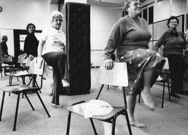
Photograph - Exercise Classes, Widows activities, 1988
Photo of ladies doing light exercises at Legacy House. From 1928 until the 1980s, Melbourne Legacy ran an excellent exercise program for its widows. Classes were held weekly at Legacy House and there was often a waiting list for the water classes, which had both swimming instruction and water exercises. Some of the class members were in their 90s, many just learning to swim.A record of activities provided for Legacy widows.Black and white photo of several older women doing light exercises using chairs.Stamped on the back: "Jul 15 4 49 AM '88", "COPYRIGHT / This photograph may not be / reproduced with permission / in writing from the / Pictoral Dept. of "The Age" / 250 Spencer Street, Melbourne, / Victoria, 3001, Australia" Taped to the back: "NEIL NEWITT 15/7/88 E.G. / SENIOR CITIZENS (WOMEN ONLY) AT / "AEROBICS" AT LEGACY HOUSE / STORY DAVID BRUCE."widows, exercise classes, activities -
 Eltham District Historical Society Inc
Photograph - Aerial Photograph, Landata, Montmorency, Feb. 1956
Centred on present day Grand Boulevard and Olympic Way, Montmorency bounded by Diamond Street to north, Old Eltham Road and Eltham Lower Park to south, Bible Street to east and Para Road to west. Historic Aerial Imagery Source: Landata.vic.gov.au Aerial Photo Details: Project No :250 Project : MELBOURNE OUTER SUBURBS PROJECT Run : 17 Frame : 115 Date : 02/1956 Film Type : B/W Camera : EAG9 Flying Height : 10000 Scale : 12000 Film Number : 1176 GDA2020 : 37°43'24"S, 145°07'55"E MGA2020 : 335375, 5823236 (55) Melways : 21 F7 (ed. 42)aerial photo, 1956-02, neil webster collection, eltham, main road, montmorency, bible street, diamond street, eltham lower park, grand boulevard, melway 21f7, old eltham road, olympic way, para road -
 Eltham District Historical Society Inc
Photograph - Aerial Photograph, Landata, Eltham, Feb. 1956
Centred on present day Mount Plaeasant Road near Dalton Street, Eltham bounded by Luck Street to north, Eltham Lower Park to south, Reynolds Road to east and Central Park to west Historic Aerial Imagery Source: Landata.vic.gov.au Aerial Photo Details: Project No :250 Project : MELBOURNE OUTER SUBURBS PROJECT Run : 18 Frame : 93 Date : 02/1956 Film Type : B/W Camera : EAG9 Flying Height : 10000 Scale : 12000 Film Number : 1176 GDA2020 : 37°43'02"S, 145°09'38"E MGA2020 : 337871, 5823961 (55) Melways : 22 B6 (ed. 42)aerial photo, 1956-02, neil webster collection, eltham, central park, eltham lower park, luck street, melway 22b6, nyora road, reynolds road, dalton street, mount pleasant road -
 Eltham District Historical Society Inc
Photograph - Aerial Photograph, Landata, Eltham, Vic, Feb. 1956
Centred on present day Parsons Avenue at Leane Drive near the Maroondah Aqueduct, Eltham bounded by Lorimer Road to north, Thompson Crescent and Norman Road to south, Bells Hill Road to east and Parsons Road to west Historic Aerial Imagery Source: Landata.vic.gov.au Aerial Photo Details: Project No :250 Project : MELBOURNE OUTER SUBURBS PROJECT Run : 19 Frame : 5 Date : 02/1956 Film Type : B/W Camera : EAG9 Flying Height : 10000 Scale : 12000 Film Number : 1176 GDA2020 : 37°42'04"S, 145°11'09"E MGA2020 : 340064, 5825786 (55) Melways : 22 H1 (ed. 42)aerial photo, 1956-02, neil webster collection, allendale road, bells hill road, eltham, leane drive, lorimer road, maroondah aqueduct, melway 22h1, norman road, parsons road, research (vic.), thompson crescent -
 Ballarat Clarendon College
Blazer pocket
Donated by A R Kyle (1916) in 1994; does not appear to have been attached to blazer. Roy Kyle entered Ballarat College in 1912. He marched with Pompey Elliott's 15th in WW1. (see in the footsteps of Pompey p. 173-4. Roy was awarded the College Cup a prestigious sporting trophy in 1912. (see VC000054) The College Cup was awarded to the competitor who won all three 120, 250 and 440 yard races. For more information about the College Cup see Ring-A-Roo December 1993. In 1996 Roy was the oldest 'Old Collegian and youngest surviving Gallipoli veteran. Roy passed away 9th October 1996. Black wool square with Ballarat College crest (embroidered Head of Minerva surrounded by thick embroidered oval in red thread)roy-kyle, ww1, ballarat-college -
 Warrnambool and District Historical Society Inc.
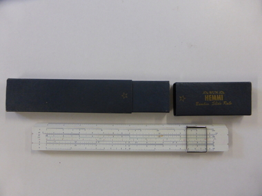
Instruments, Slide Rule, C1955
A slide rule is an instrument which is used to carry out mathematical calculations. William Oughtred is credited with its invention in 1621, however many others including Isaac Newton have made improvements or modifications over the years. From 1625 to 1800 there were approximately 40 different styles brought forward. with the following 100 years sees over 250 designs created.There have been different versions and modifications to suit scientific, mathematical and engineering requirements. It is interesting to note that many of the buildings of the 19th and 20th centuries have been designed with the use of slide rules. Their use has declined in the last 25-30 years with the advent of computers and specialist calculators.While not directly linked in any way to the history of Warrnambool, this slide rule would have been a item in use by students doing maths at upper secondary level as well as other applications which would make it a familiar object to many people.Coated bamboo with sliding metal framed glass panel or cursor . The bamboo is in three sections with the middle section movable. It is marked in various graduated measurements mainly in dark blue but with some in green and red.It is inside a dark grey rectangular box with a slide off lid on one end.There is a celluloid panel on the back with a conversion table printed on it. There is an accompanying 67 page manual with a pale green cover with black text. On slide rule:Sun Hemmi Japan No 2664S On box: Sun Hemmi Japan No 2664S warrnambool, hemmi slide rule, bamboo slide rule -
 Warrnambool and District Historical Society Inc.
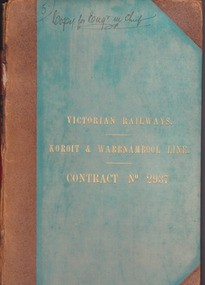
Document - Victorian Railways. Koroit & Warrnambool Line. Contract No. 2937, Circa 1888
The Victorian Railways began in 1854 and in the first 14 years up to 1868 had managed to complete about 250 miles of track. The next 60 years saw the system expand to nearly 3000 miles. By 1931 every town with a population over 500 had its own railway station. Early Victorian railway maps indicate that the extension from Colac to Warrnambool and then onwards to Koroit, occurred in the period of the 1880’s when the act known as the Octopus act saw a rapid expansion of lines. At the time there was much debate over where the expansion of the lines should take place, with one of the prime considerations for Warrnambool was the impact it would have on its port.The building of the railway to Warrnambool and onward to Koroit was a significant event for the town. Green cloth cover with tan suede corner points and spine. Title printed in gold on front cover. Title printed in gold on red on spine. 92 pages. The contract is printed and includes handwritten entries with specifications.Handwritten on front cover and inside front cover ” Copy for Engr in Chief” .On Page 2 transferred to Allan Reid * 24/1/88 Co Briscoe & Co Little Collins Street, Melbourne.warrnambool, railways, warrnambool to koroit railway, victorian railways contract no 2937 -
 Tatura Irrigation & Wartime Camps Museum
Map - Map - Photocopy, New Guinea Escape Route
At the end of January 1942 there was only about 250 men left in Wau, as the women and children had been evacuated by air a little earlier. With no planes to take the men they had to make their own way to Port Moresby and then travel by ship to Australia. Some men went down to Salamaua and made their way along the north coast, but small groups also made their way over the Owen Stanley Ranges; rafting down the Lakekamu RIver to Yule Island and by boat to Port Moresby. Donor Vanessa Kiessling's Father was part of the second group, and had drawn a detailed map of their route. This might be the same route taken by Rev. Willi Hertle (Ref C0750)Photocopy of New Guinea map showing escape routePlan of surveyed route from Edie Creek to Bulldog Dromepapua new guinea, escape, map, wau, willi hertle, kiessling -
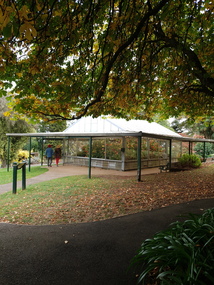 Ballarat Heritage Services
Photograph - Colour, Clare Gervasoni, Begonia Conservatory in the Wombat Botanical Gardens, Daylesford, 2019, 23/04/2019
Daylesford's begonia collection was stared by French born curator W. Gascoigne in 1885. He was an experienced horticulturalist. The plants were grown again in the 1930s in a new glasshouse. Curator Bill Greville obtained 45 plants from the Ballarat City Council, 30 from Queens Park in Essendon, and soon haad 250 tubers including a (lost) one named 'Daylesford'. When Alf Headland was appointed part-time caretaker in 1956, he found tw tubers in the wood shed and became expert in their cultivation. He continuted well into his retirement when Greg Rae too over. In 1988 the conservotory was named to honur Alf Headland's work.Hot house in the Wombat Gardens with a Begonia display.wombat botanical gardens, daylesford botanical gardens, daylesford, trees, begonia, begonia house, begonia conservatory -
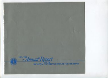 Vision Australia
Administrative record - Text, Royal Victorian Institute for the Blind annual report 1979-1980, 1979-1980
Articles in annual report include: Interest free loans up to $3000 per person were available. In 1979-1980 360 blind people and their families benefitted under this scheme and this means that $250 000 of institute funds are kept in circulation. The aids and equipment shop, introduced Kurzweil reading machine - one of the foremost organisations in the world to provide such equipment to blind people. Some years ago Mrs Cecelia Tye left her property at Romsey, now 6 buildings are used as an educational camp and two will be used for self-contained accommodation. The new building will start and finish by end 1980 and the new holiday house at Barwon Heads was opened.1 volume of text and illustrationsroyal victorian institute for the blind, corporation records -
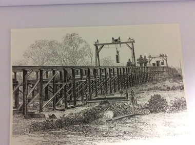 Port of Echuca
A black and white photograph of a drawing, Black and white photograph of a drawing depicting the construction of the iron Murray Bridge, at Echuca, showing Surveyor, bridge workers, hoists, a crane, and much activity, 1981
Original negative and photograph held by The Age, before by Orm Cook, Echuca. Photo is of a drawing of Bridge work taking place in 1877, across Murray River at Echuca. Orm Cook gave The Age the photograph in 1981 as the round arches on the bridge were about to be removed.A bridge crossing of the Murray River was needed by 1877. It linked Echuca and Moama in a more tangible way. The bridge was funded privately and public use of it was discussed for the next several years.A black and white photograph of a drawing, depicting the construction of the iron Murray Bridge at Echuca, showing the Surveyor, the bridge workers, hoists , a crane, and much activity.Written in pen on the back, "Murray Bridge at Echuca under construction. Original to 'Age' came from Orm Cook. Also the numbers 6530 written in pen. Also on the back is a rectangular stamp with these words inside the rectangle. "COPYRIGHT. This photograph may not be reproduced without permission in writing from the Editor of "The Age" 250 Spencer Street, Melbourne, and 39/41 York St, Sydney.murray river, bridge work, bridge construction, bridge workers., the age newspaper., orm cook. -
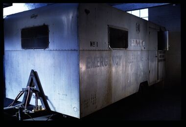 National Communication Museum
Vehicle - Mobile Telephone Exchange, c. 1965
Manufactured in the 1960s, this mobile emergency telephone exchange was fitted into a caravan. Part of the Shepparton Division State Disaster Plan, the caravan could be towed to areas affected by disasters to enable communications to recommence. The caravan remained in service until approximately 1974.Mobile infrastructure plays an important role in Australian communications, owing to the often remote and hostile environments in which Australians live and work. Exchanges such as this facilitated phone calls in the aftermath of an emergency, particularly for hospitals, police and other emergency services. Today, Mobile Exchange on Wheels (MEOWs), Cell on Wheels (CoW) and Satellite Cell on Wheels (SatCOW) - which provide temporary landline and broadband services, mobile phone coverage and service in areas without communications infrastructure respectively - are a critical part of emergency response procedures for natural disasters such as fire and flood. Though technology has progressed, the need for rapid service in remote areas remains a present concern of the communications service providers in Australia. This mobile service infrastructure is historically significant as an early example of a service which has evolved over decades, yet is still needed today. The exchange, as a representative example of a vehicle which would provide early-response in a disaster, is socially significant as a facilitator of critical communications needs in devastated communities: access to emergency services and contact with family and friends. The exchange itself, intact from its period of use, provides an insight into technology of the 1970s.Mobile emergency exchange housed in a caravan trailer on 2 wheel base, duralin body, steel tow bar, Caravan divided into 3 sections; the exchange room; the relay room and the main frame room. The exchange room contains 3 switchboards, a folding table, cupboards, benches and switch rack (.1). table (.2), steel bar for attaching the table (.3), back boards of switchboards (.4-.6), switches (.7-.16), box of switches (.17). There is a wall phone magneto, 300 type handset on wall and 2 skylights with wire screens. .11? hat pegs and shelf; there are 2 fluorescent tubes for lighting, all in exchange section. The floor is covered with 2 tone grey tiles and there are wire mesh on outside of windows and a geometric curtain inside behind switch rack. There is a flywire screen door as well as exterior door. The relay room has a sectioned door so half can open at a time. Room contains a cupboard with folding bench top beneath a curtained window. The opposite wall has a bank of batteries and transmission condensers; there is a shelf above window, one fluorescent tube and fuse boxes. Tiles on floor also. The main frame room contains many metres of coiled black covered cable, a black covered magneto wall telephone with 300 type handset; grey plastic jumper cords, a rack of termination points and wire with wasp nests attached. There is a small iron step under door, a fluorescent tube on wall and 3 hat hooks. Roll of Paper Handtowels (.18), cord and handle (.19), red exchange cords and plugs (.20-.22), plastic aluminium runners (.23,.24), headset (.25,.26), logbook (.27), battery readings (.28), box containing papers circuit drawings etc (.29-.93), paper lists off wall (.94,.95). Books, record books etc (.96-.103). Manila folder (.104) containing circuit drawings (105-.124). Wooden drawer (.125), metal drawer containing subscribers master cards, record of faults cards, particular switchboards connected, Junction line cards (.126). Box of valves (.127), box of clamps (.128). Box of 2000 type rack fuses, red 1 1/2 AMPS, black 3 AMP, blue 1/2 AMP (.129). Box of sleeves for covering wire joints (.130), plastic beakers (.131,.132), soap (.133), box of white plastic squares (.134), time switch "Venner BF/43 time switch" Made in England (.135), box of bolts, knobs etc (.136), box of switchboard number indicators (.137), fuse (.138), fuse wire (.139), football card (.140). Box of cartridge fuse 6 AMP (.141). Envelope of drawing pins, rubber bands (.142), black plastic, paper tape centres (.143-.152), metal plug (.153), 2 signs "Beware of vehicles" (.154-.155). Paper listing Naringal East automatic conversion (.156). Green Commonwealth of Australia note pad (.157). Wiring plug for tail lights (.158). Black fuse plugs (.159,.160). Box of bolts (.161). 2 sections of blue plastic coated wires (.162,.163). Gloves used for working on batteries (.164-.167). Wasp nests (.168,.169). White fuse (.170). Photographs of van in use (.171,.172)..1 on front: "ANOTHER / MOBILETRAIL / PRODUCT" "MAX SPEED / 25MPH" "TRAILER BRAKES / --- / " On sides: "EMERGENCY TELEPHONE EXCHANGE" "NO 1" "PMG" "TCQ / GROSS 250 / TARE 182 / LOAD 162" "6" "COUNTRY BRANCH / NORTH REGION / [SHEPPARTON DIVISION]" "LAW'S SIGNS" "Telecom Australia" On back: "DANGER / LONG LOAD" "MQA 3787" .133: "FIR OIL" "AUSTRALIA"mobile telephone exchanges, mobile telecommunications trailers, trailers, transport, natural disaster, black saturday, bushfires, floods, emergency communications