Showing 433 items matching "bulla"
-
 Hume City Civic Collection
Pamphlet
This is a pamphlet about the Emu Bottom Wetlands where the platypus live and swim in Jacksons Creek. The Friends of Emu Bottom Wetlands is chiefly responsible for getting the Platypus Ponds Project going. They were established in 1974 under the auspices of the former Shire of Bulla to advise and assist in the reserves, preservation and protection of the platypus.A Small pamphlet about the local platypus.Platypus Ponds/on/Jacksons Creek/Sunburyplatypus, emu bottom wetlands, emu bottom, shire of bulla, jacksons creek, sunbury, hume city -
 Eltham District Historical Society Inc
Photograph, Hume and Hovell Monument, Back Creek Road, old Back Creek school site, Back Creek, c.1998, 1998c
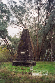
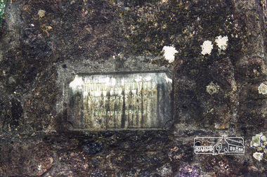
Stage 3 tour of Hume and Hovell monuments organised by Russell Yeoman. At the centenary of Hume and Hovell exploration in 1924 a committee was formed to co-ordinate and organise local celebrations along the route from Albury to Corio Bay. An itinerary was created for the unveiling ceremonies giving the hour and date for each place concerned from 15 to 21 November 1924. Thirty-three monuments or cairns were erected at Violet Town, Euroa, Avenel, Seymour, Broadford, Kilmore, Mount Bland, Bulla, Moyhu, Hansonville, Benalla, Samaria, Swanpool, Yarck, Yea, The Horn (Buffalo), Myrtleford, Whorouly, Everton, Murmungee, Stanley, Back Creek, Allan's Flat, Staghorn Flat, Ebden, Bethanga, Hume Reservoir, Strath Creek, Deer Park, Werribee, Lara, Bulla, Everton.Roll of 35mm colour negative film, 7 stripsKodak Gold 200-6activities, back creek, hume and hovell, monument -
 Eltham District Historical Society Inc
Photograph, Hume and Hovell Monument, Back Creek Road, old Back Creek school site, Back Creek, c.1998, 1998c
Stage 3 tour of Hume and Hovell monuments organised by Russell Yeoman. At the centenary of Hume and Hovell exploration in 1924 a committee was formed to co-ordinate and organise local celebrations along the route from Albury to Corio Bay. An itinerary was created for the unveiling ceremonies giving the hour and date for each place concerned from 15 to 21 November 1924. Thirty-three monuments or cairns were erected at Violet Town, Euroa, Avenel, Seymour, Broadford, Kilmore, Mount Bland, Bulla, Moyhu, Hansonville, Benalla, Samaria, Swanpool, Yarck, Yea, The Horn (Buffalo), Myrtleford, Whorouly, Everton, Murmungee, Stanley, Back Creek, Allan's Flat, Staghorn Flat, Ebden, Bethanga, Hume Reservoir, Strath Creek, Deer Park, Werribee, Lara, Bulla, Everton.Roll of 35mm colour negative film, 7 stripsKodak Gold 200-6activities, back creek, hume and hovell, monument -
 Eltham District Historical Society Inc
Photograph, Hume and Hovell Monument, Memorial Park Sports Ground, Whorouly, c.1998, 1998c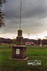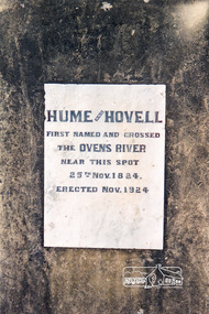
Stage 3 tour of Hume and Hovell monuments organised by Russell Yeoman. At the centenary of Hume and Hovell exploration in 1924 a committee was formed to co-ordinate and organise local celebrations along the route from Albury to Corio Bay. An itinerary was created for the unveiling ceremonies giving the hour and date for each place concerned from 15 to 21 November 1924. Thirty-three monuments or cairns were erected at Violet Town, Euroa, Avenel, Seymour, Broadford, Kilmore, Mount Bland, Bulla, Moyhu, Hansonville, Benalla, Samaria, Swanpool, Yarck, Yea, The Horn (Buffalo), Myrtleford, Whorouly, Everton, Murmungee, Stanley, Back Creek, Allan's Flat, Staghorn Flat, Ebden, Bethanga, Hume Reservoir, Strath Creek, Deer Park, Werribee, Lara, Bulla, Everton.Roll of 35mm colour negative film, 7 stripsKodak Gold 200-6activities, back creek, hume and hovell, monument -
 Sunbury Family History and Heritage Society Inc.
Photograph, School Camp, 1988
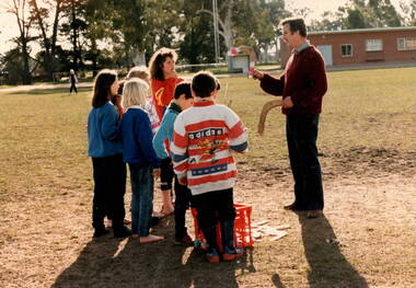
Students from Bulla and MIckleham Primary Schools attended a camp at Beechworth in 1988 where they undertook a number of different outdoor activities such as busk walking, fishing, visits to the Chinese Cemetery and boomerang throwing. In this photograph the children met with one of the local First Nation's people and were shown the art of boomerang throwing. This activity allowed the students to become familiar with aspects of the culture of First Nation's People.A coloured non-digital photograph of six children listening to a man who is holding a boomerang in each hand and instructing them in boomerang handling.The group are standing in a large sports ground with clubrooms nd tall trees in the background.school camps, mickleham primary school, bulla primary school, boomerang handling -
 Sunbury Family History and Heritage Society Inc.
Photograph, School Camp, 1988
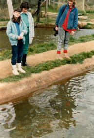
The three people were attending a school camp run attended by students, teachers and parents from Bulla and Mickleham Primary Schools. One of the activities the places the campers visited was a fish hatchery in the Beechworth area. Gail Page with her mother Lee and teacher, Carol Hitchens are standing beside one of the ponds at the hatchery. School camps provide students with many interesting extracurricular activities and wider learning experiences in a more relaxed environment beyond the classroom. A non-digital coloured print of two adults and a girl standing beside a pond. One of the adults is holding a camera while the other lady is looking for something ins the pond.school camps, fish hatchery, gael and lee page, carol hitchens -
 Sunbury Family History and Heritage Society Inc.
Photograph, 1935
The man in the photograph is John McGrath who regularly travelled to Bulla from Essendon to catch rabbits, which he sold at the market. He made a compact mobile refrigeration unit to keep the rabbits fresh in transit. His invention resulted in larger companies in Australia adopting the use of refrigerated trailers to transport perishables. Refrigerated transport systems resulted in perishables being carried quickly and to many more markets across the nation.A sepia photograph with a cream border of a man seated on a dry stone wall.mcgrath, jack. -
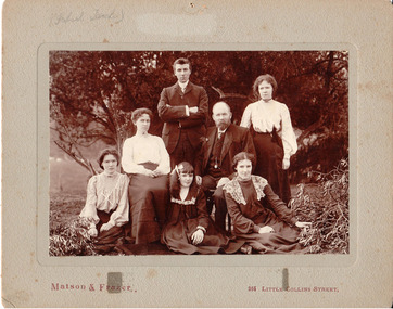
 Hume City Civic Collection
Photograph, c 1907
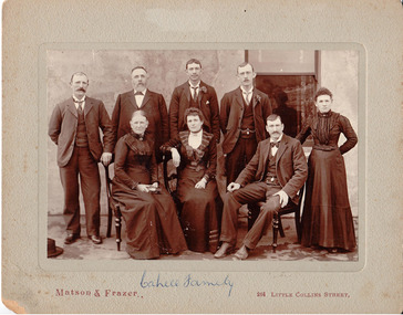
This came as part of a large collection of photos from Eric Boardman. Originally catalogued by R Waters on 12.02.1988. There are 3 copies of the original in black & white 20.5 cm x 25.5 cm format. According to information in the supplementary file from Bob Cahill who is the grandson of JF Cahill and son of Malachi Cahill, the identification of the photo is as follows: L to R (standing): James, John Francis (father), John, Malachi; L to R (seated): Mary / Margaret nee Ryan (mother), Polly (Mary), Michael (Mick) and ? (not specified) Margaret. NB/ Nora (Annie) who ran the Ball Court Hotel is missing from the photo. Other details: John Francis Cahill was a blacksmith & bootmaker and thought to be English; he married Mary or Margaret Ryan prior to coming to Sunbury. He built the Ball Court Hotel in 1854. (See 'Bulla Bulla'.) Nora (Annie) married a McGrath; Margaret married a Breen; James did not marry; Mary (Polly) married Justin Ford, Shire President in 1917. Malachi (born in 1878) married Mary Jane English. She was aged forty at the time of marriage & was originally from Ballarat. She worked at 'The Hill'. Malachi was a railway worker & died travelling on a train. There is also information about the Bulla Cahill family in the supplementary file.Mounted black & white photograph of the family of John Francis Cahill. It portrays 5 males and 3 females seated formally in front of a building. The photo is in sepia tonings mounted on a grey mount."Cahill Family" written in blue biro on the centre front of the mount below the photo; "Eric Boardman" handwritten in red pencil on the back of the mount.pioneers, cahill family, cahill, john francis, mary, ryan, john, malachi, polly, michael, ball court hotel, boardman, eric, ford, justin, matson & frazer, george evans collection -
 Sunbury Family History and Heritage Society Inc.
Photograph, School Camp, 1988
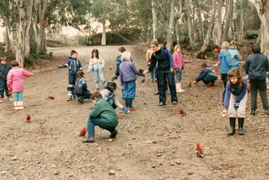
The photograph was taken when the students from Bulla and Mickleham Primary Schools combined to attend a camp at Beechworth in 1988. During that time the children were engaged in a number of different outdoor activities as a component of their outdoor education. Recognising some of the native birds of the area was one of their activities where the children experiences the birds actually landing on them.The varied activities that the children engaged in at the school camp helped to give them a better appreciation and understanding of the natural environment. A non-digital coloured photograph of a group of children with some adults in a bushland area, trying to encourage a flock of crimson rosellas to come closer by feeding them.school camps, beechworth, native birds, crimson rosellas -
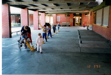 Sunbury Family History and Heritage Society Inc.
Photograph, Glengala Park Primary School, 12th March 1993
The children from Bulla Primary School visited Glengala Primary School near Sunshine in March 1993. During their visit they joined in a number of activities with the Glengala children. In this photograph they were practicing soft ball skills in the covered courtyard area. Glangala school was one of the newer schools built in the Western suburbs in the late 1980s-early 1990s. A non-digital coloured photograph of five young children being supervised by two adults in a sheltered courtyard of a school. The children are playing with a softball bats and balls. glengala primary school, bulla primary school, ball handling skills, school excursions -
 Sunbury Family History and Heritage Society Inc.
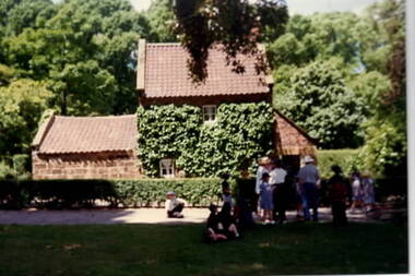
Photograph, Fitzroy Gardens
Captain Cook's Cottage was dismantled in his village in England and rebuilt in Melbourne's Fitzroy Gardens in the 1930s. Since then it has been an attraction for many visitors although there is little relationship between Captain Cook as he never set foot anywhere in Victoria. The photograph was taken when the children from Bulla Primary School were taken on an excursion to the gardens,A non-digital coloured photograph of a small brick cottage with a tiled roof in a garden setting.school excursions, bulla primary schooil, fitzroy gardens -
 Sunbury Family History and Heritage Society Inc.
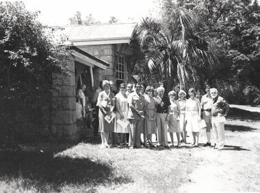
Photograph, Woodlands Homestead, c1990
Woodlands Homestead is the building in the photograph and the people standing at the entrance must have been invited by the former Shire of Bulla to visit the property when it became a tourist attraction. Des. Dumbrell, the gentleman wearing the light safari suit and standing in the front was one of the local councillors when Woodlands was opened to the public in the 1990. The park later became a home for retired racehorses.Woodlands Park became a popular tourist park within the area with many varied attractions which include the prefabricated homestead, native fauna and flora and mt. Gellibrand, the highest point in the park. A non-digital black and white photograph with a cream border, of a partial view of the entrance to a homestead built from stone with a galvanised roof. Nineteen people are gathered as a group at the main entrance. A palm tree is immediately behind the group with larger trees in the background.woodlands park, woodlands homestead, oaklands junction, shire of bulla -
 Sunbury Family History and Heritage Society Inc.
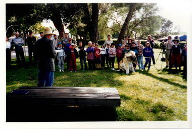
Photograph, c1989
The children from Bulla Primary School were taken on an excursion to Gellibrand hill Park which is a short distance from the School. The emphasis on the day's excursion was to identify the native fauna in the park as well as the vegetation.The property was originally settled by the Greene family in 1843. In 1980 the State Government purchased the property and it is now one of the state's parks where the natural vegetation has gradually been restored on the property. A non-digital coloured photograph of a group of adults and children listening to a man who is standing in front of a low seat and talking to them. There are buildings visible in the background. gellibrand hill, bulla primary school, school excursions -
 Hume City Civic Collection
Photograph
This photo is part of a larger collection donated by Eric Boardman. There are 6 references to O'Shea in Margaret & Trevor Dunn's Directory of Residents in the former Shire of Bulla (1850s-1920s; three of these are for Cornelius O'Shea listed in the 1891 rate books as a state school teacher, in the 1919 voters' roll as teacher and in the 1929 voters' roll as of independent means. Other references are to Joseph Michael O'Shea, Annie Agnes O'Shea and Agnes Mary O'Shea.A family group in a garden setting. There are 5 females and 2 males, with the older male and female centrally seated. A sepia photo mounted on a grey board.On the front in lead pencil in the upper LH corner of the mount board "(School teacher)"; "Eric Boardman" in red pencil on the centre back & "O'Shea family" in upper LH corner of the back of the mount board.teachers, o'shea, cornelius, matson & frazer, boardman, eric, george evans collection -
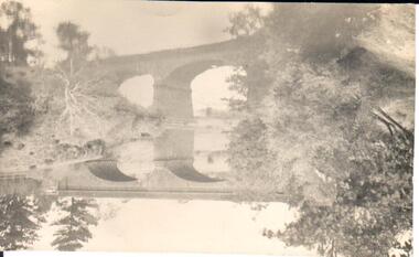 Hume City Civic Collection
Photograph
A black and white photograph of a bluestone arched bridge over Jackson Creek in Macedon Street. Taken at Easter 1934.on back: written in pen; Bridge @ Sunbury / Easter 1934cullinan, uraina, eileen, sunbury, jackson creek, macedon street, bulla, bridges, bluestone bridge, 1930s, george evans collection -
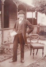 Sunbury Family History and Heritage Society Inc.
Photograph, c1900s
The man photograph in a garden is Joseph David Starkie, who was a Bulla Shire councillor for more than twenty years and during that time he was elected Shire President four times. He was also a member of the Sunbury Waterworks Trust and served as the chairman from 1905 - 1908. While serving on the water board he was instrumental in Sunbury gaining a permanent water supply. A drinking fountain has been erected on a reserve at the Village Green to honour the arrival of the permanent water supply to the town. The installation of a permanent water supply benefitted the town and contributed to a more reliable rail service as steam trains refilled their tanks with water at Sunbury Station. Prior to this the water was transported by horse and cart from nearby Jacksons Creek.A sepia photograph of a well-dressed man who is holding a book and is standing in a front garden of a weatherboard house.starkie, joseph daniel. -
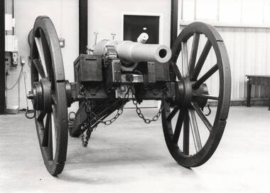 Sunbury Family History and Heritage Society Inc.
Photograph, Sunbury Gun
The Sunbury Gun was originally donated to the Shire of Bulla by the Clarke family. For many years it stood at the intersection of Barkly, Stawell and Macedon Streets. Over the years it became very dilapidated and as traffic along Macedon Street gradually increased it was decided to refresh and relocate it to a triangular site opposite the Memorial Hall in 1970. In March 1982, the weathered Sunbury Gun was restored and housed in an atmospherically controlled glass case and displayed again in the triangular site opposite the Memorial Hall along with the War Memorial and the Starkie fountain.A non-digital black and white photograph of a gun in a large building.sunbury gun, memorial hall, clarke family, stawell street, barkly street -
 Sunbury Family History and Heritage Society Inc.
Photograph, c 1920s
The 'Meeise' French car is parked outside the former Mechanics Institute Hall in Stawell Street, Sunbury. J Eadie was responsible for the building of the hall in 1885 and the foundation stone was laid by Lady Janet Clarke. The former Shire of Bulla conducted their council meetings in the hall from 1923 until 1956 when new offices were built in Macedon Street. Later the RSL took over occupancy of the hall and it became known as the Memorial Hall. In the early 1970s Stawell Street was cut off to traffic and incorporated into the Village Green.Over the years the Memorial Hall has been the venue for many community events from debutant balls, flower shows, local gatherings, celebrations and markets to name a few.A sepia photograph with a cream border of a tree lined street with a building in the foreground and a vintage car parked outside the building. Tall pine trees are growing behind the fenceline.mechanics institute, shire of bulla -
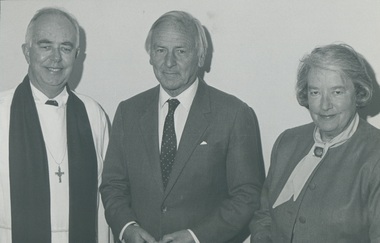 Uniting Church Archives - Synod of Victoria
Photograph, c.1986
Reverend Dr. J. Davis McCaughey (12/07/1914 - 25/03/2005) was ordained in 1942 in Northern Ireland. He served at the YMCA, Fisherwick Belfast, United Kingdom, Professor of New Testament Studies at the Theological Hall, Master of Ormond College and retired in 1979. In 1986 he became Governor of Victoria, an office he held for six years. Rev Ian Steer: b.1929; ordained 1959 at Norlane United Charge; 1963 Broadmeadows Task Force; 1972 chaplain Essendon Grammar; 1985 Sunbury-BullaB & W photograph of Rev Dr Davis McCaughey standing between Rev Ian Steer and Mrs Jean McCaughey."Dr and Mrs McCaughey Rev Ian Steer Reg News 20 December"mccaughey, davis, rev., presbyterian minister, theological hall, ormond college, governor of victoria, rev ian steer, jean mccaughey, presbyterian, minister -
Hume City Civic Collection
Booklet, Friends of the Old Sunbury Court House 10th Birthday Celebration, 1993
This booklet was put together by members of the committee of the Friends of the Old Sunbury Court House for the 10th anniversary of the former Court of Petty Sessions becoming the Sunbury Visitor Information Centre. The Sunbury Court of Petty Sessions situated in Macedon Street, Sunbury closed at the end of 1989. The community formed a committee to retain the premises to be used by the community and officially opened by the Shire of Bulla Mayor Cr. Phillip McMahon as the Sunbury Visitor Information Centre on 21st February 1993. The Visitor Information Centre operated seven days a week from 9.00am to 5.00pm.A small cream covered booklet of 27 pages including cover with black printing and a black drawing of the Old Sunbury Court House on the front cover.Friends of the Old Sunbury Court House 10th Birthday Celebration 21st February 1993 - 21st February 2003sunbury visitor information centre, visitor information centre, friends of the old sunbury court house, old sunbury courthouse, sunbury court of petty sessions, court of petty sessions -
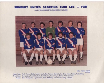 Sunbury Family History and Heritage Society Inc.
Photograph, Astra Studios, Sunbury United Sporting Club Ltd. 1981, 1981
As a result of a group of European expatriates settling in Sunbury in the 1970s and wanting to play soccer, the Sunbury United Sporting Club was formed in 1972 with the first games played on the Aussies Rules ground in Evans Street (now the Sunbury Shopping Square). After cooperation between Shire of Bulla Council to acquire an open area of land in Michells Lane, the club moved to their own ground, Langama Park in 1975. Since that date, the club has grown and today there are 3 senior and 2 junior pitches as well as 2 cricket pitches and comfortable clubrooms on the area.Sunbury United Sporting Club was one of the first Soccer Clubs to be established in the district.A scanned non-digital coloured photograph of the Sunbury United Football Club. There is a white border around the photograph and the names of the players are listed under the image. The players are wearing navy blue guernseys with a diagonal red and white stripe across the front.sunbury united sporting club., langhama park, soccer, mitchells lane -
 Sunbury Family History and Heritage Society Inc.
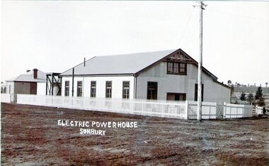
Photograph, Sunbury Powerhouse, c21st June 1910
The powerhouse in Sunbury began generating electricity for the town in 1908 after the Shire of Bulla saw the benefits of the town having electricity. It functioned until 1924 until the State Electricity Commission took over the project. The post card was written on 21 June 1910 and sent to a Miss Hillary who was living in Benalla. It was from her cousin Mr. Gregor who was a Sunbury resident. From the date on the card, the photograph must have been taken shortly after the powerhouse began operating. An engineer's cottage was built at the rear of the main building and it is still standing on its original site in Jackson Street,The establishment of an electricity supply for the town of Sunbury by the Shire of Bulla in the early decades of the twentieth century was a very advanced decision and brought lots of benefits to the town.A non-digital sepia photograph in post card format of the former Electric Powerhouse at Sunbury with a short message and address written on the back of the photograph To H.Hillary at Benalla from M.J.Gregor in Sunbury ELECTRIC POWERHOUSE/SUNBURY.electricity supplies., gregor, a., sunbury powerhouse -
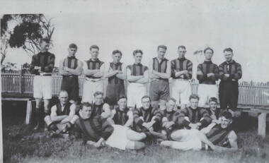 Sunbury Family History and Heritage Society Inc.
Photograph, Sunbury Football team, C 1890s
The first recorded football match played injured Sunbury was in 1881 when Sunbury played Keilor on Munro's Ground which was located on land bordered by Barkly, Shields, Harker and Evans Streets.By 1892 Sunbury Club officially became known as 'The Swifts". A later game was recorded in 1895 but it wasn't until 1897 that it became a recognised football team at a meeting convened by W.A. Eadie in the Royal Hotel. Later football matches were played on railway land in Evans and Macedon Streets. In 1949 the Shire of Bulla Council passed over 26 hectares of Crown land for a new recreation ground, now the Clarke Oval. Since that time that site has been Sunbury's home ground. Sporting clubs have played an important part in the Sunbury's social life from the latter half of the nineteenth century.A non-digital copied black and white photograph of a men's football team standing and seated in two rows in front of a picket fence. sunbury football club, "the swifts', football, sporting clubs -
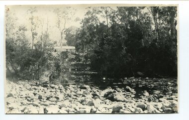 Orbost & District Historical Society
black and white photograph, April 17, 1897
This is the Nowa Nowa crossing off Old Orbost Road, to the first Nowa Nowa Hotel built by Moses Faithfull, in 1890, in background. Moses Faithful came to Australia from England with his parents on the Royal Consort in 1844. After living at Bulla, Pakenham and Wurruk he and his wife moved to Hospital Creek in about 1885 where he took up the first selection of land at Upper Hospital Creek. As well as farming he built the first hotel at Nowa Nowa in 1890. He had charge of the hotel until 1895 when he sold to Mary Stirling. Moses died on 8th July 1901, aged 66, at the residence of his son-in-law, David Price, at Newmerella, and buried in the Orbost cemetery.This hotel was built in 1890 and doubled as a coaching stop on the inland route. Settlement grew up around the hotel. It was sold 1895 to Mary Stirling who husband own the land the hotel stood on. The hotel burned down on 29 July 1955. This is a pictorial record of Nowa Nowa in the late 19th century.A black / white photograph of a creek crossing with large stones in the foreground. A bridge can be seen in the background across the creek.nowa-nowa faithful-moses stirling-hotel -
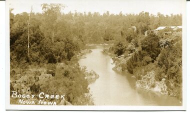 Orbost & District Historical Society
black / white photograph, late 19th - early 29th century
The building in this photograph of Boggy Creek is probably the first Nowa Nowa Hotel built by Moses Faithfull, in 1890. Moses Faithful came to Australia from England with his parents on the Royal Consort in 1844. After living at Bulla, Pakenham and Wurruk he and his wife moved to Hospital Creek in about 1885 where he took up the first selection of land at Upper Hospital Creek. As well as farming he built the first hotel at Nowa Nowa in 1890. He had charge of the hotel until 1895 when he sold to Mary Stirling. Moses died on 8th July 1901, aged 66, at the residence of his son-in-law, David Price, at Newmerella, and buried in the Orbost cemetery.This hotel was built in 1890 and doubled as a coaching stop on the inland route. Settlement grew up around the hotel. It was sold 1895 to Mary Stirling who husband own the land the hotel stood on. The hotel burned down on 29 July 1955. This is a pictorial record of Nowa Nowa in the late 19th century.A black / white photograph / postcard of a creek with a building on the rightside. a windmillis to the left. The banks of the creek are well-vegetated.on front - bottom left -"BOGGY CREEK NOWA NOWA"boggy-creek-nowa-nowa -
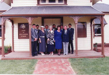 Sunbury Family History and Heritage Society Inc.
Photograph, Sunbury Courthouse, 1993
The group in the photograph at the opening of the former Sunbury Courthouse. The Courthouse was built in 1885 and functioned in that capacity until 1989 when it closed. In the 1992, Shire of Bulla council began to restore the building, which was completed in 1993. It functioned as a Tourist Information Centre until 2019, when that service was transferred into the new Global Learning Centre in Sunbury. The building is now occupied by the local Sunbury Aboriginal Corporation. Invited guests at the opening of the restoration in 1993 were from L- R: Back- Phil McMahon, Mayor, Sgt. Doug. McArthur, Sunbury police, John Munns, John Barnier, Jeff Cossum, Museum curator. L-R: Front - Peter Free, Cr. Kathy Duncan, Joy Munns and Cr. Veronica Burgess.The former Sunbury Courthouse was an important official building serving Sunbury and the surrounding area for over half a century. A non-digital coloured photograph of nine people at an official function are standing on the verandah of a weatherboard building. There is a timber notice board attached to the wall on either side of the group. phil mcmahon, doug. mcarthur, john munns, john barnier, jeff cossum, peter free, kathy duncan, joy munns, veronica burgess, sunbury courthouse, sunbury -
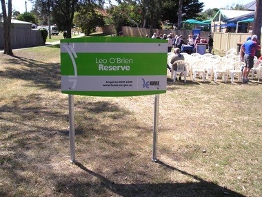 Sunbury Family History and Heritage Society Inc.
Photograph, Leo O'Brien Reserve, November 2015
The sign was erected in the reserve in November 2015. Leo O'Brien was a long time Sunbury resident and the son of Terence O'Brien, who farmed in the district. The reserve is on a section of land that Leo owned, which fronted Barkly Street to the west and Jackson Street to the east. As Sunbury developed the higher section of the property was subdivided for housing and today Terence Street is in that subdivision. The Leo O'Brien Reserve area could not be developed for housing because that land is part of the former main drain, which was a natural waterway that flowed through a part of Sunbury an entered Jacksons Creek at the end of Brook Street. Today the open drain is covered over. Terrence O'Brien served as Shire President on Shire of Bulla Council during the first two decades of the twentieth century and was also a member of the Sunbury Waterworks Trust from 1913 - 1914.A coloured photograph of sign placed at the entrance of a small open space. Tables and chairs have been set out for refreshments in the reserve.leo o'brien, leo o'brien reserve, terence o'brien -
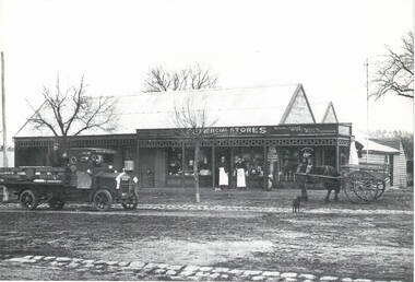 Sunbury Family History and Heritage Society Inc.
Photograph, Commercial Stores
Commercial Stores was owned and run by Peter Eadie from Perthshire in Scotland, whose brothers were John and Robert. Peter and Robert arrived in Sunbury in 1864 to help their brother John with his milling enterprise. In 1866, Peter purchased the blue stone general store in Macedon Street near the bridge. He later built the Commercial Hotel also in Macedon Street and near the Ballcourt Hotel.Before the railway arrived in Sunbury, Macedon Street was Sunbury's main commercial centre. After the establishment of the railway, the commercial centre shifted close to the railway station. The Eadie family's stately home, 'Dunblane', was on the corner of Brook and Jackson Street.A Lutheran Church now occupies the lower section of the land fronting Brook Street, but the home has a local heritage listing. Peter Eadie became a Shire of Bulla councillor and President in 1880. Dunblane is from the Scots Gaelic -'dun' is a fortified hill and 'Blane' a missionary.The Eadie Family established one of Sunbury's general stores in the town and were involved in many other commercial activities.A print of a non-digital black and white photograph of a country general store. A medium sized vintage open tray truck is parked in front of the shop on the LHSand a horse-drawn open cart is on the RHS of the image.eadie family, peter eadie, commercial stores, macedon street, businesses -
 Warrnambool and District Historical Society Inc.
Map - Maps, Soldiers Settlement WW2, Circa 1950
The soldiers' settlement scheme operated after the first and second world wars in an effort to more closely settle the land and also give opportunities to returned soldiers. Crown land and other larger estates were acquired for the purpose. Most of these maps relate to the area north of Warrnambool where many of the subdivisions were parts of larger estates.These maps pertaining to the Soldiers' Settlement program, relate to an interesting part of Australian and local history. As such they have historic and social interest and significance.A collection of 25 paper maps which relate to to the soldiers settlement post World War 2. Some have details of the people allocated the land and some smaller maps have the printed details of the applicants requirements.Text is black on white paper which in some cases is quite aged. The maps are as follows: .1 Narrapumelap Estate ( Ripon & Hampden) .2 Narrapumelap Estate Part 2 (Villers & Ripon) .3 Narrapumelap Estate Part 3 ( Villiers & Ripon) .4 Burrumbeet Estate ( Ripon) .5 ' Berrambool' Estate 9 Hampden & Villiers) .6 ' Hopkins Hill' Estate Villiers 4011 acres .7 Caramut North No 2 Estate ( Villiers ) .8 ' Morpor' Estate ( Villiers) 4172 acres .9 ' Morgiana' Estate ( Normandy) 3453 acres .10 ' Chatsworth House' ( Villiers) 9341 Acres .11 ' East Elwood' Estate Villiers 2407 acres .12 Grey's Estate ( Mornington) 1151acres .13 ' Rowes Estate' ( Buln Buln Gippsland 733 acres .14 'Tarrone' Estate No 2 Part map .15 'Chaldon Meade' Estate (Bourke) Bulla 517 acres .16 ' Terranallum South' Estate Hampden 3757 acres .17 ' Brung Brungle' Estate Dundas 695 .18 ' Armidale ' Estate ( Dundas)2108 acres .19 ' Moyne Falls' Estate ( Villiers) 627 acres .20' Yulong' Estate 9 Lowan 6321 acres .21 Murray Valley Irrigation District 9 Moira)113 acres .22 Murray Valley Irrigation District 103 acres .23 ' Mount Fyans' Estate ( Hampden) .24 ' Barwidgee ' Estate ( Villiers) 4277 acres .25 'Pine Hills' Estate 2nd portion ( Lowan) 6190 acres narrapumelap, berrambool, hopkins hill, caramut north, morpor, chatsworth house, east elwood, terrinallum, moyne falls, tarrone, caramut soldiers settlers, burrumbeet, morgiana, grey's estate mornington, chaldon meade, brung brungle