Showing 403 items
matching creek robert
-
 Stawell Historical Society Inc
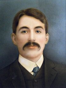
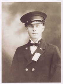
Photograph, Mr Robert Buchanan one of the founders of the Stawell Hospital -- Studio Portrait
... of the Stawell Hospital Stawell Pleasant Creek Hospital Mr Robert ...Studio Portrait of Robert Buchanan one of the founders of the Stawell Hospitalstawell pleasant creek hospital -
 Surrey Hills Historical Society Collection
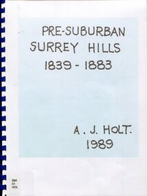
Book, Alan Judge Holt (deceased), Pre-Suburban Surrey Hills 1839-1883, 1989
Author: Alan Judge Holt amassed a significant collection of historical material related to the Surrey Hills area. Born in Moonee Ponds in 1912 to Edmund Holt and Ellen Ruby Sutton, he married Edna Jean Pallot in 1937. They lived at 62 Broughton Road, Surrey hills, had 3 sons and were strongly associated with the Surrey Hills Methodist Church. Alan was Secretary of the Victorian Lands Department and in his spare time recorded the occupancy of every property in Surrey Hills and Mont Albert at the beginning of each decade from 1890 to 1980. His collection of files and individual cards covers people, places, churches, clubs, businesses and other organisations in the area. Alan used this information to give talks and tours of the area and gifted his material to the local history collection through Jocelyn Hall.Unpublished manuscript / notes written by Alan Holt about settlers in and around Surrey Hills bound in-house. It is supported by maps showing landowners over various years from about 1840-1885(mr) henry jamieson, (mr) ken hall, (ms) edna holt, (mr) frank bamford, (mr) harrison buchanan, scouts, grange hill, wattle park, round hill, bona vista, mount albert, barton street, (mr) john raeburn, (mr) edmund holt, (mr) james dunn, butter merchant, mont albert road, elgar road, view hill, new street, surry mont, delany's hill, reservoir hill, riversdale road, middlesex road, surrey hills, (mr) aldo massora, aborigines, damper creek, back creek, west creek, kooyongkoot creek, (mr) john gardiner, (mr) chas mullins, (mr) henry elgar, (mr) robert campbell, (mr) alexander dyce, (mr) robert brooks, t budds payne, (mr) hugh glass, (mr) patrick trainer, w virtue, (mr) t fulton, (mr) john crimp, (mr) w dempsey, (mr) w e stanbridge, (mr) james atkinson, j porter, j collings, w edde, (mr) orlando fenwick, (dr)(mr) l l smith, (mr) j h knipe, (mr) george cockcroft, (sr) (mr) john martin kleinert, w morton, d delaney, a moeller, (mr) william smith, (mr) e.p.s.sturt, (mr) thomas blood, (mr) patrick mornane, (mr) henry de carle, w craig, j hill, w oliver, j keogh, a laing, vineyards, toll gates, (mr) david staig, (mr) phillip kleeper, (mr) goyder usher, (mr) james lawler, (mr) w.e. stanbridge, (mr) gideon rutherford, c a f mater, j gadsby, w h wrixon, e h lamont, i ainger, (mr) james henty, (mr) henry henty, w freemantle, w palmer, beckett park, maranoa gardens -
 Surrey Hills Historical Society Collection
Book, Early Canterbury, 1994
This booklet gives a brief description of the local settlement in Canterbury giving the landholders names and name of the house (before street numbering was introduced) and street it was located in.This booklet gives a brief description of the local settlement in Canterbury giving the landholders names and name of the house (before street numbering was introduced) and street it was located in.canterbury, (ms) jane f portingale, postmistress, (mr) arundel wrighte, wood brothers, koonung creek, (mr) thomas power, (mr) oliver russell, (mr) frederick griffin, (mr) thomas payne, shrublands, w creek, (mr) john gardiner, (mr) james shanley, (mr)robert hoddle, (mr) michael logan, (mr) patrick moloney, (mr) hugh glass, r. larkins, t. hassett, e. sturt, d.s. campbell, (mr) joseph camm, riversdale road, w. logan, rochester road, 1843, trees, mont albert road, a. sikes, (mr) william smith, 1853, (mr) ernest carter, dentist, elgar's surrey, hindson family, (mr) george granville mercy, (mr) alfred golding, (mr)alexander patterson, (mr) thomas boanas, (mr) thomas hyde, builders, (mr) richard terrill, architects, (mr) thomas miles, drapers -
 Surrey Hills Historical Society Collection
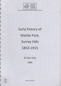
book, Early history of Wattle Park, Surrey Hills 1853-1915, 1984
Author: Alan Judge Holt amassed a significant collection of historical material related to the Surrey Hills area. Born in Moonee Ponds in 1912 to Edmund Holt and Ellen Ruby Sutton, he married Edna Jean Pallot in 1937. They lived at 62 Broughton Road, Surrey hills, had 3 sons and were strongly associated with the Surrey Hills Methodist Church. Alan was Secretary of the Victorian Lands Department and in his spare time recorded the occupancy of every property in Surrey Hills and Mont Albert at the beginning of each decade from 1890 to 1980. His collection of files and individual cards covers people, places, churches, clubs, businesses and other organisations in the area. Alan used this information to give talks and tours of the area and gifted his material to the local history collection through Jocelyn Hall.A spiral bound manuscript which includes a physical description of Wattle Park as well as covering aboriginal occupation, pastoral and timber cutting, the original purchasers and locations of neighbouring farms.back creek, wattle park, delany's paddock, cleary's paddock, blood's paddock, conran's paddock, udimore lodge, (mr) george thomas usher, (mr) orlando fenwick, phoenix grange, (mr) john filson, (mr) denis delany, (mr) john crimp, (mr) james atkinson, (mr) john lawler, (mr) henry de carle, (mr) walter craig, (mr) daniel dunn, (mr) frederick goyder, (mrs) eliza welch, metropolitan tramways, d h dureau, (mr) robert beckett, (mr) alexander gerald proudfoot, (mr) james conran, (mr) thomas blood, (mr) william smith, payne and glass -
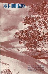 Falls Creek Historical Society
Journal - Ski-Horizon Vol. 2 No 8
Ski-Horizon is the official journal of the Federation of Victorian Ski Clubs which began publication in 1949. The were 26 original member clubs which included Albury Ski Club, Bogong Ski Club, Myrtleford Ski Club, Tallangatta and District Ski Club and Wangaratta Ski Club. Two pioneers of Falls Creek, Tom Mitchell, M.L.A., and Martin Romuld were Vice-Presidents of the Federation.This Journal is significant because it documents the early development of skiing in Victoria.The journal features stories and events chronicling developments in Victoria and internationally. Items related to the Falls Creek Area in this publication include:- Page 2: Toni St Elmo sent a list of Bogong Ski Club members who had passed N.Z. tests during their tour of New Zealand in 1950. Page 10 - 12 An extensive article (Falls Creek", written by Pauline McLean who had spent several holidays there. It includes travel requirements and restrictions and the need to acquire provisions. Reference is made to lodges including the "Skyline" and to Bill Hymans and Ron Roberts' refreshment kiosk at the foot of the tow. Page 13 Toni St Elmo is planning to have a ski tow installed for the coming season. A detailed description of the tow is included.ski history victoria, federation of victorian ski clubs, nedsa events, victorian skiing 1949 -
 Melton City Libraries
Map, Streets of Melton, 1963
MELTON’S STREETS Heritage Week 2014 What’s in a Name? Alphabetical List Aboriginal place names, Early Family Names and landowners, Agricultural, Shop and Commercial premises, Places and Events Melton & District Historical Society Street Naming Project 1972 – c 1998 Suburb Name – KURUNJANG - Kirkton, 1972, Brookfield, West, 1988 Melton and Town Centre - A joint collaboration with the Shire of Melton and Subdivision Developers ARNOLD Court – Family house - Arnolds Creek ALKEMADE Drive Family – Lime kilns Coimadia ALEXANDRA Street 1902 – Corination of King Edward VII and Queen Alexandra AVIATOR Place Event, location of plane crash – Jimmy Melrose 1936 Adina ?Annibee - Anniba? Agricultural Avon court .. .. BAKERY Square - Location of Jongebloed shop, bakehouse and stables BALUK Place Aboriginal BARLEYCORN Place Agricultural BILLING Place Name of Jimmy Melrose Uncle Noel Pemberton Billing BLACKWOOD Drive - Alexander Blackwood 1860c Registrar BARRIES Road C. E. Barrie “Darlingsford” farmer 1911, chaff mill owner BROOKLYN Road Staughton family residence. 1875 – Dismantled c 193? CAHILL Drive Family - Glenville Dairy CAMERON Court Family Canopus Place ? CANALLAN Drive Early Surveyor CAMPBELL Court Aviation – Melrose passenger 6th July 1936 CARBERRY Drive Michael, early landowner family CAREW Court Edward and Michael. Royal Hotel. Vera (Carew) Forran Singer - Opera CASEY Court Family CASHIN Court Family CHEVIOT Court Agriculture, breed of sheep CHESNEY Road was re named ( Minns Road being duplicated c 1973) CHRISTINA Crescent Christina McPherson, daughter of James and Mary Mary McPherson. Died 1955 aged 85 years COLLYER Close a deleted street (parallel to Yuille) re-used CORRIEDALE Road Breed of sheep CORR Court Teacher at first school, landowner CROXTON Court Name of the Hornbuckle and Knox family home DALEY Court - William Daley and family 1865 Bootmaker High Street DARLINGSFORD Boulevard - Name of early homestead Thomas B Darling 1853 DJERRIWARRH Court - Parish County of Bourke - very early map. DODEMAIDE Place Early land owners - Melton Football Team had 6 brothers playing c 1924 DONALD Court McPherson family 6 generations in Melton in 1936 DOUGAL Court DUNCAN Court .. .. DUNVEGAN Circuit Home of the McPherson family, castle Isle of Skye Name of bluestone house Smith Street (now at Willows) EMIL Court Jongebloed family EXELL Avenue Farming family Melton Sth- Closer Settlement 1907 EXFORD Road Exe former name of the Werribee river FARMER Court Name of early postmistress FERRIS Road John Ferris Farmer HANNAH Close First name of Hannah Watts – midwife HAYBALE Place Agricultural HELDER Court Early surveyor J Helder Wedge map HEWSON Street Winston Hewson Shire Engineer – check title c 1960 HENRY Street Township map c 1860 HESTON Street Heston Phoenix – C.J. Melrose plane HILDEGARDE Court Jimmy Melrose’s mothers name HOMESTEAD Close HORNBUCKLE Cres Farmers. Three members of family - Shire Presidents HURLEY Street Farmers IAIN Court Descendent of James and Mary McPherson JAMES MELROSE Drive Name appears on 2013 Melton information map JANG Place KURUN – jang KIRKTON Drive Name of the McPherson family home Toolern Vale Road KIRWIN Street Michael early landowners (deleted for freeway construction) KILPATRICKS Road Deleted when Barries Road was extended across Station Rd KOROROIT Court Early map, Parish of Kororoit. Creek name KNOX Circuit Family – Hornbuckle “Croxton Park” KURRUNJANG Drive Aboriginal name for people of the red earth – Suburb name Lara Place ? LLOYD Court Garage owners High Street. Laura lived to 100 years D 1955 LUBY Court John Luby – Crown Grant Land Title LITTLE Court MANNING Avenue Richard, hotel owner 1891 MARGARET Drive McPherson family McDONALD Street Melton South family name McKENZIE Street Township c1860 MORROW Street Early name MOWBRAY Crescent Name of English Melton, popularly believed origin of Melton MYERS Court Early setters c 1866 Crown Grant Land Title NIMMO Street Early name NIXON Street Name submitted by Mary nee Nixon Collins c1985 OLDERSHAW Road Early builder PALMERSTON Street Early township map c 1860 PEART Court Early name PENNYROYAL Avenue Plant growing by the creek. Early name used for the Toolern Toolam Creek PINKERTON Street Family name and early street map PINNACLE Crescent Agricultural - type of wheat PHOENIX Circuit C.J. Melrose Phoenix Heston Plane 2013 map PRATT Family PRIOR Court PYKE Place Brothers – early settlement 1838 RADFORD Court Land owners and business operators. Former Royal Hotel Grocer High Street demolished 1970 RAGLAN Court Hotel 19th century Lord Raglan RALEIGHS Road Oliver Reierson family (Norweigen) Shopkeeper – Dressmakers RIDDELL Drive (misspelt Riddle) Resident and land owner RODERICK Road McPherson family – a re occurring name ROLLAND Court Jones family ROSS Court Daniel. Landowner. Agnes Ross music teacher RUSSELL Court Robert. Early land surveyor of Melton 1853 RYAN Court Family early landowner. Member of the 1862 Road Board SHEBLER Place Augustus early Melton resident – Golden Fleece Hotel SHEEPFOLD Court Farming SHERWIN Court Sherwin Street earliest Township map– became Golf course SMITH Street Early township map. STRATHULLOH Circuit Strathtulloh Homestead. STAUGHTON Street Family – LARGE land owners Strachan ? SWANEY Court Marie Swaney earlier resident of Strathtulloh. SUTHERLAND Family name TOOLERN Street TOOLAM – TOOLERN Creek TULLIDGE St Road marked on 1861 map UNITT Street Early Township c 1860 WALLACE Square Cr Jack Wallace 5 terms as President 46 years unopposed WATTS Court Hannah Watts – midwife, cottage hospital WALSINGHAM Name of house of Minns family. From Walsingham Norfolk England WESTLEY Place Name of Jimmy Melrose Percival Gull Plane WESTLAKE Drive Early resident WHICKHAM Street Family Name Melton South WILSON Road Albert, Melton South YUILLE Street William Cross, early landowner, Rockbank run Zoomed in section of Melton Streets including Church and High Streetlandscapes of significance -
 Tarnagulla History Archive
Allen marriage certificate (copy), 3rd October 1894
Donald Clark Collection.Photocopy of a Certificate of Marriage from Dunolly Gladstone district. Parties are Ebenezer Allen (31 years) of Hillsborough Farm, Kangedaar Creek near Tarnagulla and Jane Esther Laurie (27 years) of Laurie near Tarnagulla. Minister is Robert Thomson, Presbyterian Minister. Marriage took place at Red Hill Farm, Tarnagulla. -
Tarnagulla History Archive
Handwritten note, 9 September, 1872
A large lot of papers, including this note and many telegrams, were apparently found in the ceiling cavity of the Sandy Creek/Tarnagulla Post and Telegraph Office in the later 20th Century, during building works. Donald Clark Collection. A handwritten note, probably a draft for a telegram sent from Tarnagulla Telegraph/Post Office. From John Green to James Fries (?), Manager, North Poverty G. Mi. Co., Greman's (?) Chambers, Sandhurst Message reads 'Revoke proxy to R. Rook. Appoint Robert Church'. -
Tarnagulla History Archive
Telegram, circa 1872
A large lot of papers, including this and other telegrams, were apparently found in the ceiling cavity of the Sandy Creek/Tarnagulla Post and Telegraph Office in the later 20th Century, during building works. Donald Clark Collection. Telegram sent from Sandy Creek / Tarnagulla Telegraph & Post Office. From Robert Whiteside to Mr Jailason (?) at Castlemaine Mechanics Institute. Message reads 'Don't fail in sending amount of Bill today pushed'. -
Tarnagulla History Archive
Registration of Birth form, 1871
A large lot of papers, including this and many other birth and death registration forms, were apparently found in the ceiling cavity of the Sandy Creek/Tarnagulla Post and Telegraph Office in the later 20th Century, during building works. Donald Clark Collection. Registration of Birth form for: Child's name: Lilley Annie Andrews Date of Birth: 4th September 1871 Place of birth: Llanelly Father: Robert Andrews Mother: Elizabeth Andrews (nee WIlford or Milford). -
Tarnagulla History Archive
Registration of Birth form, 1871
A large lot of papers, including this and many other birth and death registration forms, were apparently found in the ceiling cavity of the Sandy Creek/Tarnagulla Post and Telegraph Office in the later 20th Century, during building works. Donald Clark Collection. Registration of Birth form for: Child's name: Elizabeth Blanch Rumsey Date of Birth: 16th September, 1871 Place of birth: Prince of Wales Hotel, Llanelly Father: Robert Rumsey Mother: Mary Rumsey (widow, previous married surname: Grey) -
Tarnagulla History Archive
Registration of Birth form, 1871
A large lot of papers, including this and many other birth and death registration forms, were apparently found in the ceiling cavity of the Sandy Creek/Tarnagulla Post and Telegraph Office in the later 20th Century, during building works. Donald Clark Collection. Registration of Birth form for: Child's name: Thomas Roberts Date of Birth: 13th October, 1871 Place of birth: Newbridge Father: George Roberts Mother: section missing -
Tarnagulla History Archive
Registration of Birth form, 1872
A large lot of papers, including this and many other birth and death registration forms, were apparently found in the ceiling cavity of the Sandy Creek/Tarnagulla Post and Telegraph Office in the later 20th Century, during building works. Donald Clark Collection. Registration of Birth form for: Child's name: Robert Percy Peters Date of Birth: 7th January, 1872 Place of birth: Commercial Road, Tarnagulla Father: Robert Percy Peters (section damaged but known from another transcription) Mother: Mary Jane Peters (nee Falder) -
Tarnagulla History Archive
Registration of Birth form, 1872
A large lot of papers, including this and many other birth and death registration forms, were apparently found in the ceiling cavity of the Sandy Creek/Tarnagulla Post and Telegraph Office in the later 20th Century, during building works. Donald Clark Collection. Registration of Birth form for: Child's name: Robert Steel Date of Birth: 9th January, 1872 Place of birth: Newbridge Father: John Steel Mother: Bethea Steel (nee Grey) -
 Tarnagulla History Archive
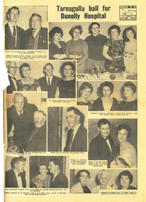
News clipping: Tarnagulla Ball for Dunolly Hospital, Tarnagulla Ball for Dunolly Hospital, September 16, 1964
Murray Comrie Collection. A page from The Weekly Times newspaper, of Sept 16, 1964 with article titled 'Tarnagulla Ball for Dunolly Hospital'. Images of Tarnagulla & district residents including Henry and Arthur Dyer, Mr & Mrs James, Mr & Mrs Hurford, Alex Freckleton and Robert Ousley (both of the Tarnagulla Hall Committee), John Shay, and others. tarnagulla, dunolly, murphys creek, maldon, people, hospital, fundraisers, hall, public hall, hall committee -
Tarnagulla History Archive
News clipping: Tarnagulla Ball for Dunolly Hospital, Tarnagulla Ball for Dunolly Hospital, September 16, 1964
Don Clark Collection Portion of a page from The Weekly Times newspaper, of Sept 16, 1964 with article titled 'Tarnagulla Ball for Dunolly Hospital'. Images of Tarnagulla & district residents including Mr & Mrs James, Mr & Mrs Hurford, Alex Freckleton and Robert Ousley (both of the Tarnagulla Hall Committee), John Shay, and others. tarnagulla, dunolly, murphys creek, maldon, people, hospital, fundraisers, hall, public hall, hall committee -
 Bendigo Historical Society Inc.
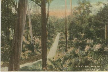
Postcard - Alice McGregor Postcard Collection, 1900 - 1920
Alice McGREGOR Born: 1908; unknown parents. Possibly adopted by the Salter family? Electoral Roll 1936: Highland Terrace Kangaroo Flat. Alice Mary Salter and William Robert Salter living together; presumed to be sister and brother. William Robert Salter was killed in a MVA in Bendigo in 1937 aged 26. In Victoria in 1938, Alice Mary Salter married James Thomas McGregor (born Victoria 1917, died Victoria 1983, buried Fawkner Cemetery) Lived: 1968; 22 Wade Street Golden Square Alice McGregor Died: 1999 aged 91 at Anne Caudle Centre, Bendigo Buried: Kangaroo Flat Cemetery See additional research. Postcard Album of Alice McGregor contained 86 post cards.Postcard Album of Alice McGregor contained 86 post cards. See 1400. Painted bush scene with Jacks' Creek Aqueduct, Whittlesea, Victoria Undated. No addressee or sender on backpostcard, collector, alice mcgregor -
 Bendigo Historical Society Inc.
Document - RED RIBBON COLLECTION: DOCUMENT THE BENDIGO PETITION AND THE RED RIBBON MOVEMENT 1853
In 1853, Bendigo Miners protested against the 30 shilling miners licence the had to pay the government. They wore red ribbons to show their protest and shopkeepers hung red ribbons outside their premises in support. Thousands of miners signed a petition to Governor LaTrobe to no avail. A protest gathering in Pall Mall marched to the Government camp on Camp Hill but this was a peaceful event again to no real avail.Typed notes on The Bendigo Petition and the Red Ribbon Movement. Amongst the petitioners were two women, Florence Foley and Sarah Williamson. Others include J H Abbott, Theodore Ballerstedt, Robert Benson, Captain Brown, W D C Denovan, William Froomes, Henry Holyoake, Doctor Jones, Frederick Ladbury and George Thomson. Also mentioned is how the petition was resolved. Further reading mentioned is: Frank Cusack's book 'A History of Bendigo entitled 'Red Ribbons in the Rain', and Geoff Hocking's book 'The Red Ribbon Rebellion - The Bendigo Petition, which contains names of those who signed the Petition. Written by the Bendigo Historical Society Inc.event, the bendigo petition and the red ribbon movement 1853, governor la trobe, florence foley, sarah williamson, j h abbott, theodore ballerstedt, robert benson, captain brown, w d c denovan, william froomes, henry holyoake, doctor jones, frederick ladbury, george thomson, george edward thomson, anti-license movement, sanders, william dixon campbell denovan, city of bendigo, back creek (bendigo) cemetery, white hills cemetery, joseph henry abbott, the diggers advocate, frank cusack, gold license fee, diggers' banner, william dexter, commissioner panton, commissioner wright, a history of bendigo, frank cusack, geoff hocking, the red ribbon rebellion - the bendigo petition, bendigo historical society inc -
 Clunes Museum
Photograph, JAMES MICHAEL HEFFERNAN, 1927
JAMES MICHAEL HEFFERNAN WAS A VOLUNTEER FIREMAN IN CLUNES FIRE BRIGADE, HE MARRIED JEAN ROBERTS IN CLUNES 14.12.1935. OCCUPATION WOOD CUTTER.BLACK AND WHITE PHOTOGRAPH OF JAMES MICHAEL HEFFERNAN BORN COGHILLS CREEK. 31.7.1910. DIED IN GEELONG 30.10.1978. PHOTOGRAPH SHOWS J. M. HEFFERNAN WEARING CLUNES FIRE BRIGADE UNIFORM IN 1927 AGED 17 YEARS.photography, fire brigade, james michael heffernan -
 Eltham District Historical Society Inc
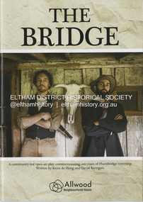
Booklet - Program, Keira de Hoog et al, The Bridge; a community-led open play commemorating 100 years of Hurstbridge township, September 2024
Program produced as part of the open air play peformed in Hurstbridge twice on the 4th and 12th of October 2024. Contents include: Allwood history - Allwood today - Construction of The Bridge - Cast - Synopsis - Directors - Crew - Hearfelt thanks and tribute to Pam Lawson. The Premiere of the open air play The Bridge performance at Hurstbridge was by members of the Allwood Neighbourhood House and the Hurstbridge Community. To commemorate 100 years of Hurstbridge township, the production was led by local historian David Kerrigan who co-wrote the play with Keira de Hoog. The quiet life of the Diamond Creek district was shattered on the 4th October 1866 when a visitor arrived seeking food and shelter. What followed has become part of the Hurstbridge story. The death of Henry Hurst by the bushranger Robert Burke and the subsequent inquest, trial and execution of Burke captured the attention of the nation. News of the event was reported nationally and in UK newspapers. Rain at sunset on opening night set the scene for the sombre story which opened with clap sticks and imagery as part of the acknowledgement of country. Attention to detail in Act One included the enactment of writing a letter that Ellen Hurst had actually written back to her family in England, days before the incident, which set the scene – and choreography of the “capture” of Burke immediately following the shooting as drawn by the engraver Robert Bruce and published in 1866. The cast, crew and audience moved around the actual physical site the altercation took place till the final act and judgement of Sir Redmond Barry to execute Burke. The souvenir program given to ticket holders includes photos and biographies of the cast taken in costume at Gulf Station, Yarra Glen, together with background information and the narrative of the play. Guests on opening night – 158 years ago to the day of the event included Dianne Switzer, descendent of pioneer Cornelius Hailley and Rob Fergusson, descendent of Henry Hurst. plays, hurstbridge, allwood neighbourhood house -
 Eltham District Historical Society Inc
Photograph - Digital Photograph, Alan King, St Andrews Anglican Church, St Andrews, 30 January 2008
Built c.1868, St Andrew’s Anglican Church is Nillumbik Shire’s oldest timber church and is historically, socially, and spiritually significant to the Shire of Nillumbik. The church is historically significant because it may have given its name 'St Andrews' to the town (another suggestion is that the name came from the local hotel), it is also historically significant as one of only four buildings that remain from the Caledonian goldfields era of Queenstown (now St Andrews) and one of only a handful of buildings that survived the 1960s bushfires. The church is historically, socially, and spiritually significant because it has played an important part in community life for more than 150 years; a proposal to move the church in 1984 met with strenuous opposition. Much of the fires on Black Saturday 2009 were the north of the town. The town itself remained intact - as did this heritage building. Covered under Heritage Overlay, Nillumbik Planning Scheme. National Trust of Australia (Victoria) Local significance Published: Nillumbik Now and Then / Marguerite Marshall 2008; photographs Alan King with Marguerite Marshall.; p69 The St Andrews Anglican Church and former St Andrews Primary School, are two reminders of the district’s early days, when it was founded on gold. St Andrews, then called Queenstown, was the earliest goldfield in the Caledonia Diggings.1 It was the Upper Diamond Gold Mining and Administrative Centre, with 3000 miners. Queenstown was also the seat of the Court of Petty Sessions. The church and school then stood close to European and Chinese stores, three hotels, a brewery and a quartz mill.2 In 1861, Queenstown was officially proclaimed a township. From 1865, the name Queenstown was interchangeable with St Andrews, until 1952, when the town was officially named St Andrews. As gold declined from the early 1880s, Queenstown changed dramatically into a settlement of small farms. St Andrew’s Anglican Church, built in 1868, is the Shire’s oldest timber church and possibly gave its name to the township.3 The small timber church was opened on November 1, 1869, by the Dean of Melbourne. Anniversary tea meetings helped raise funds, and in 1889, a three-bedroom parsonage was built alongside. In 1910, the vicar, the Rev Selwyn Chase (and friend of the Scouting Movement’s founder, Baden Powell), established the 1st Queenstown Scout Troop, only two years after Scouting began in Australia. The church was important to the lives of many local residents who were baptised, married and had funeral services there. But by the 1950s the population had decreased and so did the weekly attendances. Around the mid-1960s the church closed, then fell into disrepair. So in the mid 1980s it was sold to the Education Department and was under threat of relocation or demolition. However this caused such opposition from locals,4 that instead, the Anglican church leased it as part of the Panton Hill parish5 and it was reconsecrated in 1987. Queenstown’s first school was held in a tent after transferring from Andersons Creek, Warrandyte.6 From 1858 a church school, Caledonia Diggings, stood west of the main road, a quarter of a mile (0.4km) before Buttermans Track. In 1882 the school was moved from a leased building, owned by headmaster Robert Harris, into a larger building on the corner of the School and the Heidelberg-Kinglake Roads. It had been moved from Smiths Gully and included a teacher’s three-roomed residence.7 In 1887 the school was replaced by the Queenstown State School No 128, although it was also called Caledonia Diggings until 1891. In 1956 it was renamed St Andrews. Still standing, this building is now used as the St Andrews Community Centre and the residence is leased for private use. The original timber-lined room remains alongside the extensions, and is distinctive with its high ceiling and tall small-paned windows. In 1984 a new school was built 500 metres west of the old school. Many residents have contributed much to St Andrews but one family that has done so for several generations is the Harris family. Robert Harris was an active member of the St Andrew’s Anglican Church, and worked hard at improving the town’s amenities until his death in 1887. He was a signatory to the successful 1863 petition to the Chief Commissioner of Police, against the proposed removal of the Court of Petty Sessions and police station at the Caledonia Diggings. The police station stayed in the town until 1917. Harris was Head Teacher of Queenstown State School from 1864 to 1874, then of the Smiths Gully school until it closed in 1882, and he continued teaching at Panton Hill until his death. His son, Robert Charles Harris, was editor and printer of the local newspaper, The Evelyn Observer, from 1873 until 1915. Robert’s son, William Shelley Harris, served in the Boer War and in World War One. In 1928 he became Kinglake National Park’s first park ranger. Robert’s daughter Elizabeth, taught needlework at Queenstown State School, and later ran the post office in Kinglake.This collection of almost 130 photos about places and people within the Shire of Nillumbik, an urban and rural municipality in Melbourne's north, contributes to an understanding of the history of the Shire. Published in 2008 immediately prior to the Black Saturday bushfires of February 7, 2009, it documents sites that were impacted, and in some cases destroyed by the fires. It includes photographs taken especially for the publication, creating a unique time capsule representing the Shire in the early 21st century. It remains the most recent comprehenesive publication devoted to the Shire's history connecting local residents to the past. nillumbik now and then (marshall-king) collection, st andrews, st andrews anglican church -
 Eltham District Historical Society Inc
Photograph - Digital Photograph, Marguerite Marshall, Eltham Community and Reception Centre, 2 October 2006
The Eltham Community and Reception Centre was Australia's first public mud-brick building. Commissioned in 1977 by Eltham Shire Council, led by Shire president (and architect) Robert Marshall, architects Whitford and Peck were asked to design a multipurpose facility in mud-brick and timber. The official opening was performed by the Hon. R.J. Hamer; E.D., M.P., Premier of Victorai on Saturday, April 22, 1978. Architects: Whitford & Peck Pty Ltd Quantity Surveyor: D.J. Cant & Associates Structural Civil Engineers: Charlett & Moore Pty Ltd Landscape: Peter Glass, Dennis Edwards Mech Elec: Lobley Treidel & Partners Pty Ltd Acoustics: Riley Barden & Kirkhope Builder: L.U. Simon Pty Ltd Covered under Heritage Overlay, Nillumbik Planning Scheme. Published: Nillumbik Now and Then / Marguerite Marshall 2008; photographs Alan King with Marguerite Marshall.; p177 The Wiggles performed there, so has the ABC’s Play School. New citizens have made their vows, volunteers have been honoured, school children have performed, weddings celebrated and people mourned at funerals. Since 1978 the Eltham Community and Reception Centre at the corner of Pitt Street and Main Road, has provided a beautiful and quintessential Eltham environment for people from all over Melbourne. Recognised as Australia’s first public mud-brick building, the centre was built partly on the site of the parsonage of the former Methodist Church (now the Uniting Church).1 Commissioned by the Eltham Council headed by President Robert Marshall, architects Whitford and Peck were asked to design a multipurpose facility in mud-brick and timber. Following public consultation, it was agreed to build a centre for dances, exhibitions, films, plays or concerts. The results – at a cost of around $620,000 – captured the Eltham rustic style. The building – in soft tones of mud-brick and timber and immense floor-to-ceiling windows – overlooks the Diamond Creek and sporting fields. Eltham’s strong artistic heritage is reflected in the centre. Although the lighting is not ideal for a gallery and labels cannot be placed on walls, the centre hosts the Nillumbik Art Awards and displays around ten to 20% of the Nillumbik Shire Art Collection, usually for around a year at a time.2 On permanent display, close to the entrance, is local artist Clifton Pugh’s White Choughs in the Landscape. Further to the right is the Walter Withers Gallery, named after a local member of the Heidelberg School of artists. As part of the Eltham Gateway opposite the Eltham Hotel, the centre stands on what was once part of the Eltham Town Centre along this section of Main Road, then known as Maria Street. On the same site once stood the house and flour mill owned by Henry Dendy, best known as the founder of Brighton, although he lived longer in Eltham. Beside the drive is a wheel-rim tool with accompanying plaque, illustrating a technology important during the horse-powered age and now almost completely gone, as has the blacksmith’s shop that had housed it nearby. The implement is a platform for fitting iron tyres to the wooden rims of cartwheels. Beneath it is a capsule placed in 1985 to commemorate Victoria’s 150 years, which is to be opened in 2035. Although the plants, forming part of the landscaping by Peter Glass and Denis Edwards, are largely indigenous and other native species, some exotic plants are protected as an important link with the site’s past. Planted at the front around 1920, is a large Peppercorn tree with two joined trunks growing from the base, and close by is a Bhutan Cypress (Cupressus torulosa). Three other Peppercorn trees fringe the drive. The building includes two halls – the larger seating 250 people – and a large foyer overlooking trees and ovals. Both halls have retractable rear walls providing varying spaces as required, and guests can use several external decks. A site for outdoor theatre has been carved out of the natural slope outside the entrance. The Bricklayers Union refused to use the traditional mud-bricks, which weigh more than 22kg. As a result the mud-bricks were redesigned to reduce their weight and were laid back-to-back to produce a wall of normal thickness.3 The centre’s massive timber frame is reminiscent of timber bridge construction, with infill panels of mud-brick.4 In accord with the rustic style are colossal rough-sawn posts, bolts and steel brackets. The combination of mud-brick, exposed feature timber framing and creative design in this centre, characterises Eltham’s innovative buildings and the social movement behind them from the 1940s to the 1970s.This collection of almost 130 photos about places and people within the Shire of Nillumbik, an urban and rural municipality in Melbourne's north, contributes to an understanding of the history of the Shire. Published in 2008 immediately prior to the Black Saturday bushfires of February 7, 2009, it documents sites that were impacted, and in some cases destroyed by the fires. It includes photographs taken especially for the publication, creating a unique time capsule representing the Shire in the early 21st century. It remains the most recent comprehenesive publication devoted to the Shire's history connecting local residents to the past. nillumbik now and then (marshall-king) collection, eltham community and reception centre, mudbrick construction -
Federation University Historical Collection
Magazine - Booklet, Ballarat School of Mines Students' Magazine, 1916, 1916
School Council, Members of Staff, Editorial, Fumes from the Lab, Ancient Craft Classes and the Apprenticeship Question, Magazine Editorial Staff, The Trip to Bradshaw's Creek, Arts & Crafts Gossip, In Memoriam - E. J. Cannon, Echoes of the Past, The Haunted Tram Car, Old Boys', Sport, Shun!! Military Notes, The Junior TechsBlue soft covered magazine of 62 pages. Former students mentioned are John Walter Sutherland, Basil Sawyer, Charles Burbury, Herbert Sleeman, Eustace M. Watson. Oliver E. Jaeger, Oliver e. Jager, Godfrey Stephen Hart, Lionel J. Lambert, Charles G. Fraser, L.W.G. Buchner-Malcolm, James A. Reid, Richard G. Walker, Leslie J. Coulter, Herbert E. Hawkesworth, Leslie de Jersey Grut, Frederick G. Brisnden, Reginald Callister, Lewis J. Westcott, Angus D. Gibson, Henry Whittingham, Virgil Tucker, Norman C. Tinworth, Charles E. Finnis, Benjamin H. Bennett, Valentine G. Anderson, Ernest S. Anderson, Ralph I. Moore, John A. Grant, William Geldard, Francis C. Hall, Harold G. Cornell, Robert H. Lamb, Sydney Radcliff, George A. Denny. Frederick P. Paul, H. Lipson Hancock, Edgar C. Hurdsfield, David W. Bonar. Wilfred L. Allen, William J. Lakeland, Frederick A. Marriott, Eric Byron Moore, NOrman Stuckey, PErcy H. Osborne, John F. Spornballarat school of mines, magazine, f. maxwell, n. turnbull, g. procter, e. seimering, l. tonkin, w. carrol, h. smith, r. cox, j. a. greenshields, jnr, r. o. buchanan, l. vernon, a. bowman, w. h. steane, n. henry, r. dale, e. j. cannon, ted cannon, lance-corporal e. j. cannon, charles w. whyte, patrick s. anderson, william t. sayer, william f. m. johnson, robert m. sergeant, harold t. w. dixon, harrie wilson, ernest s. morsehead, carl jensen, corpl. r. sergeant, sergt. h. dixon, q.m.s. t. wilkins, captain james fairbairn fairley, sergt. e. morshead, sergt. hy. wilson, lieut. l. c. blick, f. g. procter, f. g. davies, gladstone procter, bradshaw's creek, edwin cannon, art library -
Eltham District Historical Society Inc
Document - Sharp family
Keith Sharp was a descendant of the Hurst family, and lived in Hurstbridge, being active in the Hurstbridge Country Fire Authority. His family's farm gave its name to Sharps road, Hurstbridge. Contents Gwen Sharp, no date: Photocopy of collection of material on Sharp family of Hurstbridge and naming of Sharps Road containing: Photograph Fergusen's paddock, Hurstbridge, 1987. Notes on renaming of Sharp's Flat to Sharps Road. Notes on the Hurst family and how Keith Sharp is descended from Ellen Hurst, with details of each generation. Photographs of Sharp family and of Hurstbridge. Photograph of Allwood House, 1899, including W G Gray, Carrie Sharp and Robert Sharp. Newspaper clippings, A4 photocopies, etcgwen sharp, sharp's flat hurstbridge, sharps road hurstbridge, arthurs creek, hurstbridge, hurst private memorial grave site, robert hurst, frances hurst, hurst's bridge, ellen hurst, keith sharp, sheila ferguson, henry facey hurst, charles botterell hawkins, fanny hawkins nee hurst, caroline frances maria sharp nee hawkins, robert nehemiah sharp, "the oaks" kinglake, william sharp, edgar sharp, harry sharp, stan sharp, daisy sharp, "homeleigh" hurstbridge, roy sharp, jean sharp, lilian sharp, allwood house hurstbridge, ferguson's paddock hurstbridge, arthur's creek road, carrie sharp, sharps house hurstbridge, dorset house hurstbridge, ryans butcher hurstbdirge, hortons bakery hurstbridge, bootmaker hurstbridge, d g graham blacksmith hurstbridge, noella macperson nee sharp, richard sharp, robert sharp, muriel sharp, edna sharp, lyn sharp, muriel sharp nee limmer, muriel willson, henry willson, country fire authority hurstbridge -
 Federation University Historical Collection
Letter - Document, Early History of H. A. Phillips, 1960 a
Hand written document of 15 pages - photocopiedh a phillips, mt blowhard railway station, ascot, coghill's creek, "the rose", the rose hotel, rose of australia hotel, coghill's creek state school, mrs cantwell, john gottlobb phillips, dowling forest estate, jim mcrae, sir alexander james peacock, nuriootpa farm, mount cavern, education act (1850s) certificatae, australian natives association, bright and hitchcocks geelong, iris woodhouse, duncan phillips, james mcrae, john lester, elizabeth roberts, alice may telford, leongatha, john phillips, george phillips, douglas west, dorothy bagnall -
 Bendigo Historical Society Inc.
Postcard - Alice McGregor Postcard Collection, 1900 - 1920
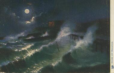
Alice McGREGOR Born: 1908; unknown parents. Possibly adopted by the Salter family? Electoral Roll 1936: Highland Terrace Kangaroo Flat. Alice Mary Salter and William Robert Salter living together; presumed to be sister and brother. William Robert Salter was killed in a MVA in Bendigo in 1937 aged 26. In Victoria in 1938, Alice Mary Salter married James Thomas McGregor (born Victoria 1917, died Victoria 1983, buried Fawkner Cemetery) Lived: 1968; 22 Wade Street Golden Square Alice McGregor Died: 1999 aged 91 at Anne Caudle Centre, Bendigo Buried: Kangaroo Flat Cemetery See additional research. Postcard Album of Alice McGregor contained 86 post cards.Postcard Album of Alice McGregor containing 86 postcards. See 1400 Coloured image entitled 'Storm off Brighton'. Dark moonlit night with rough seas. Just visible is a pier on the right. Lights of a house in background. Hull of a ship in centre? Addressee - Miss H.Y. Shatford, Watson's Creek, via Kangaroo Grounds, Melbourne Sender J Y D Dated Jan 31, 1906 postcard, collector, alice mcgregor -
 Federation University Historical Collection
Map, Ballaarat Gold Field, 1861, 1861
A party of surveyors camped by Yuille's Swamp (later Lake Wendouree) and surveyed the countryside for a map to be produced by the Geological Survey of Victoria. In November 2004 the Central Highlands Regional Library presented a special edition of 200 copies of the 1861 map reproduced from a copy in their collection. Original 1861 map of Ballarat showing streets and leads. Blue dots indicate gold leads, and red lines indicate auriferous quartz reef and outcrops of quartz veins."Compiled & Drawn from the Survey of Mining Surveyors Davidson, Fitzpatrick and Cowan & the Plans in the Surveyor General's Office by J. Brahe, 21st October 1861. R. Brough Smyth, Secretary for Mines. The Honourable J.B. Humffray, M.L.A. Commr of Mines.”ballarat, map, ballarat east, lake wendouree, survey, mines, robert davidson, ballarat gold field 1861, yuille's swamp, wendouree swamp, little bendigo diggings, gold leads, old post office hill, specimen hill, bakery hill, black hill, dead horse creek, brown hill, pennyweight hill, clayton hill, soldiers hill, golden point, gum tree flat, white flat, poverty hill, chinese village, robert brough smyth, ballarat map 1861, ballaarat vineyard, dead horse gully, deadhorse creek, invermay, black hill flat, gaelic church, police reserve, magpie range, dalton's flat, caadian lead, rifle butts, powder magazine, bathing house, government camp, gold office, chinese, llanberrris, victoria theatre, charlie napier hotel, united states hotel, grape's hoel, clayton's hill, cattleyard hill, free trade hotel, esmond lead, bakery hill, black hill lead, juvenile reformatory, ballarat orphanage, lady barkly lead, triffet's slaughter yard, little bendigo, melbourne road, t. cowan, thomas cowan -
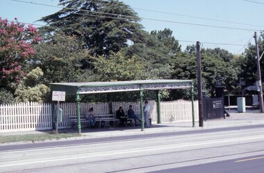 Melbourne Tram Museum
Slide - Set of 17 - Tramway Shelters, Robert Green, c1990
Set of 17 colour slides of tramway shelters, poles, and substations by Robert Green c1990. Shelters by the PMTT, HTT and MMTB 1 Tramway Shelter (PMTT) - Cnr Balaclava and Orrong Road, Caulfield 2 - ditto 3 - Tramway Shelter (PMTT) - Cnr. Cotham Road and Burke Road, Deepdene 4 - Tramway Shelter (PMTT) - Cnr. Cotham Road and Burke Road, Deepdene with telephone box alongside. 5 - Cnr. Malvern Rd and Orrong Road, Toorak 6 - Cnr. Malvern Rd and Orrong Road, Toorak 7 - Cnr. Dandenong Road and Hawthorn Road, Caufield 8 - ditto 9 - PMTT Substation - Rusden Street, Elsternwick 10 - PMTT poles cnr. Dandenong Road and Wattletree Road 11 - Tram shelter (HTT) Riversdale Road and Highfield Road - Camberwell - Highfield Park 12 - Tram shelter (HTT) Riversdale Road and Wattlevalley Road, Camberwell 13 - ditto 14 - Tram shelter (HTT) Camberwell Road, cnr Bowen St. Camberwell. 15 - Tram Shelter (HTT) Camberwell Depot, Riversdale Road, Hawthorn 16 - Merri Creek Bridge, St. Georges Road, North Fitzroy 17 - Merri Creek Bridge, St. Georges Road, North Fitzroy - foundation stone Yields information about Melbourne's tramway stop shelters and other infrastructure.Set of 17 Kodak colour slides in plastic mounts.tramways, shelters, caufield, deepdene, toorak, orrong road, cotham road, balaclava road, pmtt, htt, mmtb, riversdale road, camberwell depot, merri creek bridge, foundation stone, dandenong road, poles, rusden st, substations, hawthorn road, st.georges road -
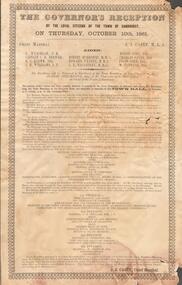 Bendigo Historical Society Inc.
Document - GOVERNOR'S RECEPTION 1861
Victorian Governor, Sir Henry Barkly visited Bendigo in Oct. 1861 as part of his regional tour that included, Castlemaine, Chewton, Back Creek and Inglewood.Buff coloured document. Written on top 'The Governor's Reception by the Loyal Citizens of the Town of Sandhurst on Thursday October 10th 1861. The program for the day is detailed, with instructions as to the order that participants should muster before the greeting of the Governor at the City Boundary at Kangaroo Flat. 'His Excellency will be welcomed to Sandhurst at the Town Boundary at Two o'clock p.m by Robert Strickland Esq. J.P. Chairman of the Municipality on behalf of the People of Sandhurst'bendigo, council, governor's reception 1861 -
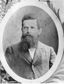 Stawell Historical Society Inc
Photograph, Mr Alfred Clemes -- Studio Portrait
Portrait of Alfred Clemes. Chemist then Shire Secretary. Alfred Clemes was a Shire Secretary from 1871-1915. He was born at Austell, Cornwell in 1829. Clemes arrived in Pleasant Creek in 1858 where he set up a business as a chemist. Ref p.91 "Good Country for a Grant" A History of Stawell Shire by Robert Kingston. Black and white photograph of a bust of a male, with full beard - white shirt, dark buttoned coat. Setting oval with design in corners. Mounted in brown folder.Hand written on back of folder Mr. Clemes Secretarystawell