Showing 12750 items
matching estates
-
 Warrnambool and District Historical Society Inc.
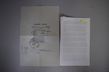
Map and Article, Dunmore, 1 1954 .2 1970
Both these items deal with the property of Dunmore, in the Macarthur/Hawkesdale/ Woolsthorpe area of Western Victoria. The first item is a sheet of paper with a map and details of the sale of portion of Dunmore in 1954. This is an original document. The second item is a history written by Stan Baulch of the property Dunmore from its establishment up to 1970. Dunmore was first established by Charles Hamilton MacKnight and two partners in 1842 and it was purchased by Samuel Baulch in 1893. After Samuel Baulch’s death the property was bequeathed to his three sons. One son, Stanley Baulch (1897-1980) took over the eastern portion which he named Rose Park. Stan Baulch was a member of the Warrnambool and District Historical Society and wrote several articles on aspects of his life and work, including this valuable article on the history of Dunmore. These items are of significance as they concern the estate of Dunmore in Western Victoria, an early and important property which is still farming land today under various owners. .1 This is a sheet of paper containing a map of the Dunmore property on one side and details of the sale of portion of Dunmore on the other side. The map has been annotated in handwritten black ink. The page has been folded twice. .2 This is an article typed on 12 foolscap pages. The typing is somewhat faint in places. ‘Dunmore’ Estate Dunmore baulch family, western district, victoria, dunmore estate, macarthur/hawkesdale, history of warrnambool -
 Warrnambool and District Historical Society Inc.
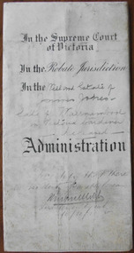
Document - James Jones Letters of Administration 1910, 1910
Tait collection: item 29 of 62 This document contains information on the Will and Letters of Administration of James Jones, a gardener from Warrnambool. The document indicates that he died intestate in August 1896 at the age of 57 but details of a will are included in the document. The fact that this document was drawn up 14 years after his death indicates that there was a problem with the will. James Jones left real estate to the value of £80 and personal estate to the value of £10. The sole beneficiary was his widow, Mary Ann Jones. No other information has been found on James Jones. No Warrnambool lawyer is mentioned in this document but it was located at the former legal premises in Kepler Street of Mackay Taylor and passed on to the Warrnambool and District Historical Society in 2014. It is presumed that it had been passed down to successive lawyers occupying the same building since 1910. This document is of interest because it contains information on the Will and Letters of Administration of a Warrnambool resident, James Jones. It will be useful for research.This is a cream-coloured piece of parchment paper (1910) folded in two with handwritten material on three sides. The first page has black printed material in script with the information filled in in black ink. It contains the information on the Will and Letters of Administration of James Jones, a gardener from Warrnambool. The paper is ruled on one side with black lines. The seal of the Supreme Court of Victoria is attached with green ribbon. One page is very stained. In the Supreme Court of Victoria; In the Probate Jurisdiction; In the Will and Estate of James Jones late of Warrnambool in Victoria Gardener deceasedjames jones, warrnambool, tait collection -
 Warrnambool and District Historical Society Inc.
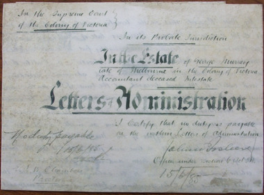
Document - George Murray Letters of Administration 1883, 1885
No information is available on George Murray except that he was a Melbourne accountant and died intestate in 1885. He left property to the value of £91 and the lawyer, Ernest Chambers, who was at that time at 12 Chancery Lane, Melbourne, was directed to list the creditors of George Murray and distribute the estate accordingly. Mr Chambers was one of George Murray’s creditors. Ernest Chambers later had a legal practice with offices at Warrnambool, Koroit and Port Fairy with the known dates 1897 to 1910. Thomas Goodall was the manager of the Warrnambool office and he was the one who had this document in his possession at that time and it was passed down to succeeding lawyers in the Kepler Street building. Tait collection: item 7 of 62This document is of interest in that it was originally issued by the lawyer Ernest Chambers who later had an office in Warrnambool. This is a piece of parchment containing the 1885 Letters of Administration in the estate of George Murray, a Melbourne accountant. The document is white with black ruled lines and has handwritten material in black ink. The document is folded at the lower edge with a seal of the Supreme Court of the Colony of Victoria. The seal is attached to the document by a green ribbon. There is also a blue stamp of the Master in Equity of the Supreme Court. The document is in good condition apart from some minor staining. ‘In the Supreme Court of the Colony of Victoria in its probate jurisdiction, in the Estate of George Murray, late of Melbourne in the Colony of Victoria, accountant, deceased intestate, Letters of Administration, I certify that no duty is payable on the within Letters of Administration, John W. … (office under section 6), 15/6/85’. george murray, ernest chambers, warrnambool -
 Whitehorse Historical Society Inc.
Book, A Journey through Melbourne's East, 2008
A Pictorial journey through the eastern suburbs from Hawthorn to Templestowe, Box Hill, Blackburn and Mitcham.A Pictorial journey through the eastern suburbs from Hawthorn to Templestowe, Box Hill, Blackburn and Mitcham, where Fletchers Real Estate has operated over the years since it began in Kew in 1919.A Pictorial journey through the eastern suburbs from Hawthorn to Templestowe, Box Hill, Blackburn and Mitcham.fletcher and parker, fletchers, real estate agents, box hill, blackburn, mitcham -
 Phillip Island and District Historical Society Inc.
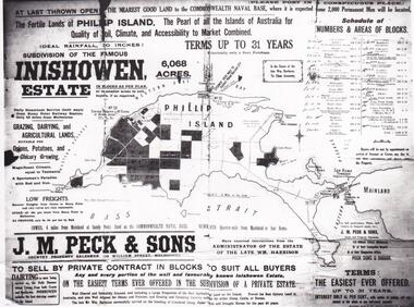
Map & Newspaper clipping, The Argus, Inishowen Estate, c1910 and 3/11/1868
Selection of land on Phillip island. Early subdivision of "Inishowen" Estate.449-01: Map of Phillip island showing "Inishowen" Estate c 1910 449-02: Newspaper article on the selection of land plus listing of people who obtained land. Argus 03/11/1868.inishowen estate phillip island, phillip island land selection 1868 -
 Stawell Historical Society Inc
Photograph, Mechanics Institute in Upper Main Street Stawell 1970 -- Coloured and Black & white copies
Mechanics Institute Main Street Stawell. Used for many years as the library. Colour photo c1970s. Built in 1875 after the previous institute was damaged by fire in 1874. Architect Mr. George Inskip. Previous wooden institute destroyed by fire in 1866. McKellar Building in background. Hairdresser and Grampians real estate signs visible.Angle on photograph of Mechanics Institute Building. Cars parked in street in Foreground. Hairdresser and Grampians real estate signs visible.Mechanics Institute 1875stawell streetscape -
 Kew Historical Society Inc
Plan - Subdivision Plan, Jas R Mathers Son & McMillan, Eastlawn Estate : East Kew Auction Sale, 1914
The Kew Historical Society's map collection includes a substantial number of real estate subdivision plans, mainly of Kew but also of surrounding suburbs in Melbourne. Most of the subdivision plans date from the 1920s and 1930s when the districts old homes and local farmland were being split up to accommodate residential growth in the postwar period. These early plans were assembled by a local firm, Jas R Mather & McMillan, which had an office in Cotham Road. Many of the plans, and sometimes photos, were annotated by the agents.Subdivision plans are historically important documents used as evidence for the growth of suburbs in Australia. They frequently provide information about when the land was sold as well as evidence relating to surveyors and real estate and financial agents. The numerous subdivision plans in the Kew Historical Society's collection represent working documents, ranging from the initial sketches made in planning a subdivision to printed plans on which auctioneers or agents listed the prices for which individual lots were sold. In a number of cases, the reverse of a subdivision plan in the collection includes a photograph of a house that was also for sale by the agent. These photographs provide significant heritage information relating house design and decoration, fencing and household gardens.The photograph may also be aesthetically significant depending on the importance of the photographic atelier.The ‘Eastlawn Estate’ was surveyed and ready for auction in March 1914, three months before the outbreak of World War I. Sixty-six allotments, created on the ‘order of Mr & Miss Preston’ surrounded the mansion of Woodlands in Harp Road. Woodlands formed part of the Estate, being advertised as lot 1. The allotments faced High, Station and Wright Streets, Harp and Normanby Roads, and Woodlands Avenue. Pru Sanderson in the Kew Conservation Study (Vol.2, 1988) wrote that the Eastlawn Estate ‘covered the western half of the failed Harp of Erin Estate’. Contemporary advertisements promoted the Eastlawn Estate as: ‘There will be no more convenient district nor pleasant Suburb than East Kew for the busy business man. When the Electric Tram is laid, he will be able to journey quickly and pleasantly direct from Collins Street to his home in the Eastlawn Estate in about 20 minutes’. The actual plans of subdivision were included in advertisements in The Argus and in the local newspapers."C" top left. Various annotations.subdivision plans - kew, station street, normanby road, high street, woodlands avenue, harp road, woodlands - kew -
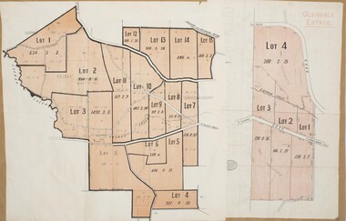
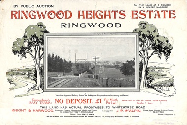 Ringwood and District Historical Society
Flyer, Subdivision Advertisement - Ringwood Heights Estate Public Auction - March, 1924
Refer also to Reg. No. 5185 for Ringwood Heights Estate final section release (August 1924)Folded double-sided brochure advertising Ringwood Heights Estate Public Auction on Saturday March 1, 1924, with town photographs, location map, terms of sale, and summary of local features and services.Subdivision includes Whitehorse Road, Bon View Avenue, Grant Crescent, Hillcrest Avenue, Heatherbrae Avenue, Margaret Street, and Mary Street. (Agents) Knight & Harwood, 315 Collins Street, Melbourne, Phones Central 10615, 10616, in conjunction with J.B. McAlpin, Opposite Railway Station, Ringwood, Phone Ringwood 7. -
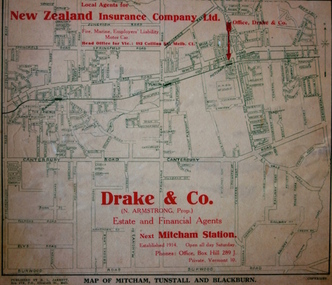 Kew Historical Society Inc
Map - Street Map, R L Jarrett, Map of Mitcham, Tunstall and Blackburn, 1929
Tunstall was originally the name of Nunawading Railway Station. Tunstall opened on 4 June 1888 and was renamed on 1 November 1945. An historically significant advertising map that can be used to ascertain the extent of urban development in 1929 in the areas of Nunawading, Blackburn and Mitcham.A map of Mitcham, Tunstall and Blackburn found on the reverse of a real estate subdivision plan published by R. L. Jarrett of Elizabeth Street. This promotional street map is overprinted with the business address of the sponsors and advertising. Map overlaid in red print: "Drake & Co. / (N. Armstrong, Prop.) / Estate and Financial Agents / next Mitcham Station / Established 1914. Open all day Saturday. / Phones: Office, Box Hill 289 J. / Private, Vermont 10."real estate agents, mitcham, tunstall, blackburn, road maps, drake & co, new zealand insurance co ltd -
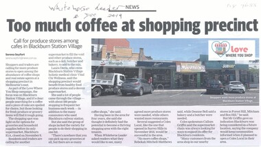 Whitehorse Historical Society Inc.
Article, Coffee Shops, 02/12/2019
Blackburn Village Shopping Centre.Blackburn Village Shopping Centre now has a glut of Coffee Shops and Real Estate Agents and a lack of options for groceries and household supplies since IGA closed on Nov 8th.Blackburn Village Shopping Centre. blackburn village shopping centre, shops -
 Ringwood and District Historical Society
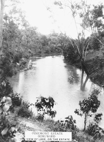
Photograph, Pinemont Estate, Ringwood. View of lake
Label on photograph reads, "Pinemont Estate, Ringwood. View of lake, on the estate". (2 copies) -
 Ringwood and District Historical Society
Flyer, Subdivisional Land Auction Sale Brochure, Grand Central Estate, Ringwood, Vic. - 1925
Douglas Street shown in the estate plan did not eventuate, but was developed as a public reserve. Refer also to Reg. No. 5149 for 1924 auction sale of land also titled Grand View Estate situated further north in Ringwood.Double sided multi-folded page advertising public auction sale on Saturday, 31st October, 1925, of residential allotments highlighting local facilities, services and layout of the estate. Includes panoramic view of Ringwood and other local photographic images.Subdivision includes Great Ryrie Street, Heathmont Road, Douglas Street, Garden Street, and Bellevue Avenue. Agents - Knight & Harwood, 315 Collins Street, Melbourne, Phone 10615, 10616 Central, in conjunction with J.B. McAlpin, Opposite Railway Station, Ringwood. Phone Ringwood 7. -
 Kew Historical Society Inc
Map - Subdivision Plan, Grenville Estate, 1922
Pru Sanderson, in her groundbreaking ‘City of Kew Urban Conservation Study : Volume 2 - Development History’ (1988), summarised the periods of urban development and subdivisions of land in Kew. The periods that she identified included 1845-1880, 1880-1893, 1893-1921, 1921-1933, 1933-1943, and Post-War Development. These periods were selected as they represented periods of rapid growth or decline in urban development. An obvious starting point for Sanderson’s groupings involved population growth and the associated economic cycles. These cycles also highlighted urban expansion onto land that was predominantly rural, although in other cases it represented the decline and breakup of large estates. A number of the plans in the Kew Historical Society’s collection can also be found in other collections, such as those of the State Library of Victoria and the Boroondara Library Service. A number are however unique to the collection.Subdivision plans are historically important documents used as evidence of the growth of suburbs in Australia. They frequently provide information about when the land was sold on which a built structure was subsequently constructed as well as evidence relating to surveyors and real estate and financial agents. The numerous subdivision plans in the Kew Historical Society's collection represent working documents, ranging from the initial sketches made in planning a subdivision to printed plans on which auctioneers or agents listed the prices for which individual lots were sold. In a number of cases, the reverse of a subdivision plan in the collection includes a photograph of a house that was also for sale by the agent. These photographs provide significant heritage information relating house design and decoration, fencing and household gardens.In advertising the twenty-two sites of the Grenville Estate in Cotham Road and Alfred Street, Kew, the auctioneers emphasised the proximity of the development to shops, schools, and churches. That mansions surrounded the Estate was publicised as an added attraction. The plan shows how at this stage A regrettable aspect of this plan is that it is pasted over, and obscures a real estate photograph by the Kew photographer Josiah Earl Barnes.subdivision plans - kew, grenville estate, glenferrie road, alfred street, thomas street, cotham road -
 Kew Historical Society Inc
Plan - Subdivision Plan, Myrtle Park Estate, City of Camberwell, 1916
The Kew Historical Society collection includes almost 100 subdivision plans pertaining to suburbs of the City of Melbourne. Most of these are of Kew, Kew East or Studley Park, although a smaller number are plans of Camberwell, Deepdene, Balwyn and Hawthorn. It is believed that the majority of the plans were gifted to the Society by persons connected with the real estate firm - J. R. Mathers and McMillan, 136 Cotham Road, Kew. The Plans in the collection are rarely in pristine form, being working plans on which the agent would write notes and record lots sold and the prices of these. The subdivision plans are historically significant examples of the growth of urban Melbourne from the beginning of the 20th Century up until the 1980s. A number of the plans are double-sided and often include a photograph on the reverse. A number of the latter are by noted photographers such as J.E. Barnes.The ‘Myrtle Park Estate’ was a subdivision bounded by Victoria Road (now Lansdowne Street), Buchanan Avenue and Dight Avenue. Other streets that were created by the subdivision included Eurolie Street, Boorahman Street and Moody Street (now Sylvan Street). The Estate took its name from Myrtle Park (later changed to Macleay Park), which had been created in 1923 by Camberwell Council. The Park adjoined the southeast corner of the new subdivision. The Estate included 74 regular allotments characterised by narrow frontages and long blocks. Confusion may have greeted prospective purchasers as the Estate was advertised in the daily newspapers as being in East Kew, rather than in Camberwell, where it was at that stage located.subdivision plans - balwyn, myrtle park estate - camberwell [surrey hills] -
 Surrey Hills Historical Society Collection
Photograph, 111-113 Union Road intersection with Windsor Crescent, 1985
There are earlier photos of this building both in this collection and one on the SLV website. James Sneddon's real estate business was an earlier occupant. Doubleday's occupied the site for nearly 3 decades. Later uses were as a kitchen showroom and a cafe.Colour photo taken on a wet winter's day showing Doubleday Real Estate Agents on the north eastern corner of the intersection. The opposite corner of Windsor Crescent is not visible. Rear in blue biro: "Union Road - Windsor Crescent". Handwriting not recognised. -
 Melton City Libraries
Photograph, Darlingsford, Unknown
Darlingsford Estatelocal identities, local architecture, council -
 Melton City Libraries
Photograph, Deanside, Unknown
'Deanside' estatelocal architecture -
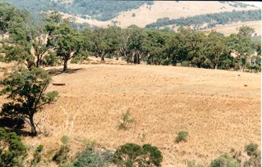 Hume City Civic Collection
Photograph, c late 1980s
The series of photographs show a number of sites included in the Rupertswood Estate. By 1851 William Clarke had acquired 31,375 acres of land in the Sunbury district. The foundation stone for Rupertswood Mansion was laid on 29th August 1874 by Mrs. W. J. Clarke, daughter-in-law of 'Big Bull'. The Salesian Fathers bought the Rupertswood property in June 1927 and established Salesian College.A coloured photograph of an open valley with scrub which is part of the original Rupertswood Estate. This land is north of the mansion and existing Salesian College.rupertswood estate, clarke, william j. t. 'big bull', salesian brothers, george evans collection -
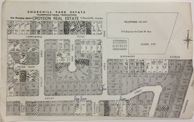 Kew Historical Society Inc
Plan - Subdivision Plan, Churchill Park Estate, Templestowe
Historic subdivision plan of the Churchill Park Estate in Templestowe.Undated subdivision plan advertising the Churchill Park Estate inTemplestowe. Streets identified in the plan include: Corroboree Place, Astley Street, Jeffrey Street, Airds Road, Dove Court, Potter Court, Thompsons Road, Richards Street, and Birchwood Avenue.Annotations in ink on the plan by agentsubdivision plans - templestowe (vic), churchill park estate - templestowe (vic) -
 Warrnambool and District Historical Society Inc.
Documents, William Ardlie Archives, C 1900-1940
This collection of papers have come from the offices of William Ardlie a local solicitor. He was born in Moonee Ponds in 1843 and was admitted as an attorney and solicitor of the supreme Court in 1865. From 1867 to 1878 he was in partnership with George Barber and then continued to practise until his late eighties which made him the oldest practising lawyer in Australia. He was involved in local councils and organisations such as the Hospital and Anglican Church.He was associated with several large homes in Warrnambool including Wyton presently the home of Emmanual College Warrnambool. He died in 1933.His son E L Ardlie also practised as a solicitor from the same offices from 1893. A number of the invoices included relate to the Estate of James drought who was a local policeman and owner of a number of properties and operated in various trades such as George Ramsay manufacturer of stoves and chimneys, J Rogers plumber & gas fitter and Christian & Dodds who were carpenters and joiners. There are a number of documents which relate to the Chinese, many of whom operated market gardens along the Merri River. They were a familiar part of Warrnambool from around 1872 until around 1940. The names mentioned in these documents include Ah Foo,Charles Quing Bow, Andrew Quing Bow Ah Bing Ah Jing Ah Moon and Ah Seong. They were reknown for their supply of fresh vegetables to the people of the town. They leased land from John Moore. These documents are a cross section of the types of documents which were used and are still used in the operation of businesses. They provide a social snapshot of people and the business which they conducted with their solicitors in this case William and E L Ardlie who were a long standing legal firm in the district. Another interesting aspect of some of these documents is the leases signed by the Chinese market gardeners who played an important but often overlooked aspect of Warrnambool's aspect.A total of 27 documents which relate to William Ardlie Solicitors 001133.1Policy from The Victoria Insurance Company for office effects, 001133.1.2 Receipt for 11/1 for policy. 001133.2 Renewal Receipt from Messrs Hammond & Richards as agents for Victoria Insurance Co. 001133.3 Renewal Receipt from Messrs Hammond & Richards as agents for Victoria Insurance Co. 001133.4 General rates receipt . City of Warrnmbool. 001133.5 Water rates receipt . City of Warrnmbool. 001133.6 Camperdown Chronicle , Letter re overdue payment 001133.7 Camperdown Chronicle Statement 31/12/1948 001133.8 Transfer of land notice Ben Rogers Mepunga 001133.9 W H Philpott Account for rent Estate R P Thomas 001133.10 George Ramsay account for Mr Walters for stove setting. 001133.11 Archibald Macfarlane & Co account for Estate James Drought for advertising. 001133.12 Letter to E L Ardlie re deed of Keane family arrangements 21/10/1910 001133.13 Letter to E L Ardlie re charges of Keane Estate 14/12/1910 001133.14 Account to E L Ardlie from J Rogers re estate Mr Drought , repairs.1/08/1906 001133.15 Account to EL Ardlie from J Rogers re estate Mr Drought1/10/1907 001133.16 Account to William Ardlie from J Rogers re estate Mr Drought 01/07/1908 001133.17 Account to William Ardlie from J Rogers re estate Mr Drought 01/07/1908 001133.18 State Savings Bank Victoria passbook of Margaret Molan 1/02/1937 001133.19 Account to E L Ardlie from Christian & Dodds repairs to Droughts house 01/07/1905 001133.20 Account to E L Ardlie from Christian & Dodds for Estate of Drought for house repairs Darling St1/10/1905 001133.21 Estimate to A A Briggs from Christian & Dodds for Estate of Drought 06/04/1908 001133.22 Receipt to E L Ardlie from Christian & Dodds for Estate of Drought for house repairs 01/05/1906 001133.23 Lease Indenture 02/06/1922 between William Ardlie andAH Foo re Crown Allotment 144 Wangoom for 70 pounds. 001133.24 Agreement 18/06/1929 Messrs Quing Bow & Sons to Messrs Ah Bing Ah Jing Ah Moon and Ah Seong witnessed John Moore. 001133.25 Lease indenture made 18/06/1929 betweenWilliam Ardlie to messrs Ah Bing Ah Jing Ah Moon and Ah Seong. 001133.26 Agreement 18/06/1929 Messrs Quing Bow & Sons to Messrs Ah Bing Ah Jing Ah Moon and Ah Seong witnessed John Moore 001133.27.1 Notification to Creditor of issue of stay order farmers Debts adjustment Act 1935 to Ellen C McGinness and Estate of john McGinness 001133.27.2Note re monthly inst of interest Estate McGinness1942 001133.27.3 Estate of j A Bromfield re Estate of McGinness Arrears of Interest1943 001133.27.4 Letter to W Ardlie from The Trustees Executors & Agency Co Ltd24/02/1944 re interest on J A Bromfield's trust re McGinness mortgage. 001133.27.5 Letter to W Ardlie from The Trustees Executors & Agency Co Ltd 25/02/1944 re interest on J A Bromfield's trust re McGinness mortgage. 001133.27.6 William Ardlie to The Trustees Executors & Agency Co Ltd re Bromfield & McGinness 24/02/1944 001133.27.7 The Trustees Executors & Agency Co Ltd to William Ardlie re receipts 16/03/1944 001133.27.8 The Trustees Executors & Agency Co Ltd to William Ardlie re Bromfield & McGinness18/03/1944 Unable to complete enquiries. 001133.27.9 The Trustees Executors & Agency Co Ltd to William Ardlie 27/03/1944 001133.27.10 The Trustees Executors & Agency Co Ltd to William Ardlie29/04/1944 001133.27.11 Estate Sarah Donaldson re accrued Interest 1933-1961 001133.28.1 Indenture between Emily Maria Briggs,Mary Jane Briggs, Frederick William Briggs, Fanny Alethea Briggs, James Alfred Briggs,Lucy Annie Briggs, Arthur Albert Briggs , and Mary Ann Briggs 001133.28.2 Letter re estate of Mary Ann Briggs 001133.1 No 590911 001133.1.2 Signed G Begley 001133.2 Hammond & Richards 43/5 Kepler St Warrnambool 001133.3 Hammond & Richards 43/5 Kepler St Warrnambool 03/03/1934 001133.4 W Ardlie 18/06/1929 Thomas Beattie collector 001133.5 W Ardlie 18/06/1929 Thomas Beattie collector 001133.6 Wm Ardlie signed W A Donald10/08/1949 001133.7 Wm Ardlie 31/12/1948 001133.8 Alexander Ben Rogers 26/05/1950 001133.9 Estate R P Thomas 28/061955. Phone 124 001133.10 .Mr Walters Drought A Ramsay 01/05/1906 001133.11 Estate of the late James Drought 24/05/1906 001133.12 W F Molesworth Re Thomas Keane. Phone 81. 21/10/1910 001133.13 W F Molesworth Phone 81 Thomas Keane14/12/1910 001133.14 E L Ardlie Joseph Rogers 13/08/1906 001133.15 E L Ardlie Joseph Rogers 01/10/1907 001133.16 E L Ardlie 01/07/1908 001133.17 Estate Late Mr Drought 01/07/1908 001133.18 Miss Margaret Molan 001133.29 L Ardlie 01/07/1905 001133.20 E L Ardlie 01/10/1905 001133.21 Mr A A Briggs Christian & Dodds 06/04/1908 001133.22 L Ardlie W Christian 01/05/1906 001133.23 Stamp duty 04/061926 Signed William Ardlie Est Conway Ah Foo 001133.24 Signed John Moore, Charles Quing Bow, Andrew Quing Bow, Ah Bing, Ah Jing, Ah Moon, Ah Seong. 001133.25 Signed William Ardlie, E H Conway, Ah Bing, Ah Jing, Ah Moon, Ah Seong, John Moore. 001133.26 Signed John Moore, Charles Quing Bow, Andrew Quing Bow, Ah Bing, Ah Jing, Ah Moon, Ah Seong. 001133.27.1 Ellen C McGinness and Estate of John McGinness James Dickson R R Macfarlane Richard Vincent McGinness, Abraham McGinness, John Ambrose McGinness 14/07/1936 001133.27.2 Note re monthly inst of interest Estate McGinness 1942 001133.27.3 J A Bromfield McGinness 001133.27.4 W Ardlie, The Trustees Executors & Agency Co Ltd 24/02/1944 J A Bromfield's trust re McGinness mortgage. Syd Jackson 001133.27.5 W Ardlie ,The Trustees Executors & Agency Co Ltd 25/02/1944 J A Bromfield's trust re McGinness mortgage.Syd Jackson 001133.27.6 William Ardlie The Trustees Executors & Agency Co Ltd re Bromfield & McGinness 24/02/1944 001133.27.7 The Trustees Executors & Agency Co Ltd William Ardlie 16/03/1944 001133.27.8 The Trustees Executors & Agency Co Ltd William Ardlie Bromfield & McGinness 18/03/1944 001133.27.9 The Trustees Executors & Agency Co Ltd William Ardlie 27/03/1944 001133.27.10 The Trustees Executors & Agency Co Ltd William Ardlie 29/04/1944 001133.27.11 Estate Sarah Donaldson 1933-1961 001133.28.1 Miss Emily m Briggs to Mrs Mary Ann Briggs Assignment . Stamped William Ardlie Solicitor Warrnambool. warrnambool,, william ardlie, james drought, christian & dodds, chinese of warrnambool, james a bromfield -
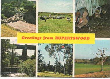 Sunbury Family History and Heritage Society Inc.
Postcard, Murfett Publishers, 'Rupertswood', C1970s
The post card waas assembled by Salesian College, which is in Rupertswood Mansion. The six images are sites within the Rupertswood Estate and are as follows: Clockwise from L-R- Sheep at the Bridge crossing at Jacksons Creek, Friesan Stud sale, Shearing sheep, Jackson Creek flats, Rupertswood Mansion, Railway bridge spanning Jacksons Creek. Initially Salesian College started as an agricultural school training boys in farm skills. It is now a co-educational secondary college.A postcard with six non-digital photographs of sites within the Rupertswood Estate. Information about each site and the manufacturer's details are on the back of the card.Across the centre of the postcard: GREETINGS FROM RUPERTSWOODrupertswood mansion, salesian college, railway viaduct, jacksons creek, sheep shearing, friesan cattle, sunbury -
 Bacchus Marsh & District Historical Society
Map, Glenvale Estate and Glenmore Estate Land Sales 1909
The two land auction plans shown in this record relate to the sale of land from the Glenmore Estate property. The Glenmore property was established by C.J. (Charles James) Griffith and James Moore around 1840. Moore sold his interest to Moelesworth Greene in 1848. Greene was the nephew of the other owner Charles Griffith who died in 1863. From around the 1870s onwards parts of the Estate were subdivided and put up for sale or lease. In subsequent decades more changes in ownership occurred. These two plans document another major sale of the land from the original Glenmore Estate including part of the estate which had become used for dairy farming and was at that time known as the Glenvale Estate. Two single page maps pasted together on a single page of a bound volume of maps. One map shows 15 separate lots of land for sale. The other map which has the words 'Glenvale Estate' at the top of the map shows 4 lots of land for sale. Both parcels of land were originally part of the Glenmore Estate a pastoral holding belonging to C.J. Griffith and James Moore which the began in the Rowsley area south west of Bacchus Marsh in the 1840s. The maps are pasted into a bound volume containing 76 maps or plans in total. High resolution digital image stored on BMDHS computer network. bacchus marsh victoria maps, glenvale estate property, glenvale estate land sales, glenmore estate, glenmore station -
Whitehorse Historical Society Inc.
Document, Australian Social History House Research Assignment, 1986
Social History of 2 Gordon Crescent, Blackburn,Social History of 2 Gordon Crescent, Blackburn, included - History of Blackburn, Architecture of the House and first owner, Thomas Richards Burrowes. Morton. Real Estate Brochures, Maps, Photos, Floor Plans.Social History of 2 Gordon Crescent, Blackburn, morton thomas richards burrowes, architecture -
 Ringwood and District Historical Society
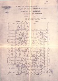
Document - Folder, Land Sale, Parkhaven Estate, Heathmont, Victoria - 1968
Manilla folder containing 2-page foolscap size typewritten summary of Parkhaven Estate Heathmont multiple release allotment prices and two maps headed Plan of Subdivision - Part of Crown Portion 13, Parish of Ringwood. Subdivision includes Cuthbert Street, Waterloo Street, Sunset Drive, Markhill Place, Parkhaven Drive, Bayley Close and Blenheim Street. Agents - Consolidated Home Industries Limited, Lower Dandenong Road, Braeside, Vic., Phone 91-9791. Rep - Bruce Grant.Accompanying handwritten sales note researched in 2024 by Richard Carter - Carter Real Estate - "Generally $2500 to $4000 per lot". -
 Kew Historical Society Inc
Plan - Subdivision Plan, J R Mathers & McMillan, Glenarbor Estate, 1934
Pru Sanderson, in her groundbreaking ‘City of Kew Urban Conservation Study : Volume 2 - Development History’ (1988), summarised the periods of urban development and subdivisions of land in Kew. The periods that she identified included 1845-1880, 1880-1893, 1893-1921, 1921-1933, 1933-1943, and Post-War Development. These periods were selected as they represented periods of rapid growth or decline in urban development. An obvious starting point for Sanderson’s groupings involved population growth and the associated economic cycles. These cycles also highlighted urban expansion onto land that was predominantly rural, although in other cases it represented the decline and breakup of large estates. A number of the plans in the Kew Historical Society’s collection can also be found in other collections, such as those of the State Library of Victoria and the Boroondara Library Service. A number are however unique to the collection.The Kew Historical Society collection includes almost 100 subdivision plans pertaining to suburbs of the City of Melbourne. Most of these are of Kew, Kew East or Studley Park, although a smaller number are plans of Camberwell, Deepdene, Balwyn and Hawthorn. It is believed that the majority of the plans were gifted to the Society by persons connected with the real estate firm - J. R. Mathers and McMillan, 136 Cotham Road, Kew. The Plans in the collection are rarely in pristine form, being working plans on which the agent would write notes and record lots sold and the prices of these. The subdivision plans are historically significant examples of the growth of urban Melbourne from the beginning of the 20th Century up until the 1980s. A number of the plans are double-sided and often include a photograph on the reverse. A number of the latter are by noted photographers such as J.E. Barnes.The little-known Glenarbor Estate comprised 23 allotments bordering Wellington and Denmark Streets and Fenton Avenue. The auction of the allotments in the Estate was held in the Kew Recreation Hall. The purported advantages to Kew are identified on the plan, such as the close proximity of the entrance to the Kew Railway Station and access to shops in Denmark Street. Due to its location, the subdivision was pitched at commercial as well as residential purchasers. The Estate was to cause a crisis in the Kew Council as a majority of councillors voted on 29 May to acquire the entire Estate as the location of a new Town Hall. The Estate was said to be valued at £50,000. A later meeting was to rescind the vote, instead opting for the compulsory acquisition of South Esk on the corner of Charles Street and Cotham Road. That acquisition was to be overturned by the State Government. The debate about the purchase of the Glenarbor Estate by Council coincided with the decision to widen High Street on the South side between Cotham Road and the Junction."D"subdivision plans - kew, glenarbor estate, wellington street, denmark street -
 Phillip Island and District Historical Society Inc.
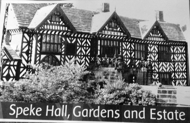
Photograph, Speke Hall
The ship Speke, which was wrecked in 1906 near Kitty Miller Bay, was named after the town Speke in Liverpool, where Speke Hall is located. Source http://www.nationaltrustcollections.org.uk/place/speke-hall Speke Hall This half-timbered Tudor courtyard house acquired its present shape during the 16th century under the ownership of Sir William Norris and his grandson, also Sir William. It was completed, except for some minor additions, for Edward Norris by 1606. The predominant architectural message of Speke is the decorative potential of wood. The exterior, with its high proportion of timber to infill, is a riot of geometrical patterning, while many of the Tudor interiors are filled with carved and embellished panelling – including a genealogical overmantel from c.1560 – some probably imported from the Low Countries, where the Norrises had trading connections. After a period of neglect, Speke was restored and entirely refurnished in the mid-19th century by the Watt family. 2 x Large photos of Speke Hall - 1 Black & White, 1 coloured.Speke Hall, Gardens and Estatethe speke, sailing boats, shipwrecks, photographs, speke hall -
![Artwork, other - Uprising [Aufruhr] 1899, Kathe Kollwitz](/media/collectors/5f33390821ea670db8ae2a22/items/5fa359ec5e1c2613780f2a8a/item-media/5fdaa4ec9c62551d2055d2f8/item-fit-380x285.jpg) Bass Coast Shire Council - Robert Smith Collection
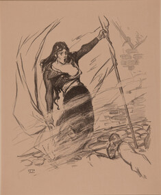
Bass Coast Shire Council - Robert Smith CollectionArtwork, other - Uprising [Aufruhr] 1899, Kathe Kollwitz
German 1867 - 1945Etching K.44, related to the Weavers cycleArtists estate stamp l.r -
 Bass Coast Shire Council - Robert Smith Collection
Artwork, other - The Last Refuge of Liberty c.1871, Theophile-Alexandre Steinlen
[1859 - 1923]LithographInitialled l.l Estate stamp -
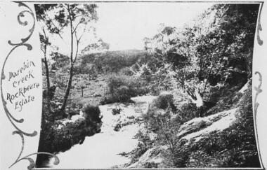 Darebin Parklands Association
Darebin Creek Rockbeare Estate 1909, Darebin Parklands Association, 1909
Previous record no. C 1909. Found in a manila folder titled {Historical photographs} Items found in collection gathered together by the author of the Darebin Parklands history 2011.B&W photograph. This item and all other Darebin Parklands Association archival material is now held by State Library Victoria (Accession No: YMS 13746). Please contact State Library Victoria if access is required.[Darebin Creek Rockbeare Estate] -
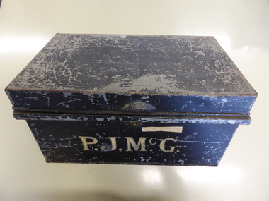 Warrnambool and District Historical Society Inc.
Box, Tin Box McGennan
Peter McGennan (1839-1920) arrived in Warrnambool in the 1870s and established a cooperage in Kepler Street and a boating business on the Hopkins River. He rebuilt the boating establishment after a fire in 1876. In 1896 McGennan established a Box and Case Factory in Davis Street (Merrivale Drive), importing timber from New Zealand, using chartered vessels and his own ships which included the ‘Speculant’. The box factory was a successful venture employing over 30 men until it was destroyed by fire in 1923. Peter McGennan was involved in the establishment of the Warrnambool Cheese and Butter Factory at Allansford and the Warrnambool Woollen Mill. He was a Director of the latter company until his death. Members of the McGennan family were also important business people in Warrnambool, being involved in the hotel business and civic affairs for many years. The tin box may have been used to house family papers or business documents during Peter McGennan’s life and it was used to house his estate papers after his death. Many of these documents are in the collection of the Warrnambool &District Historical Society.This box is of some importance as it belonged to a prominent Warrnambool businessman and his family. It has social significance as an example of the type of storage items used early in the 20th century to hold documents etc.This is a rectangular tin box with the black paint on the outside peeling and yellow paint inside. There is a metal lock which has no key. There is a small handle on the top added to the tin surface. The name ‘P.J.McGennan’ is painted on the front side in yellow paint.‘P.J.McGennan’ A typed label on faded yellow adhesive tape ‘Estate P.J.McGennan’ peter mcgennan, p j mcgennan, peter mcgennan metal box, mcgennan box factory, mcgennan warrnambool