Showing 1864 items
matching present day
-
 Eltham District Historical Society Inc
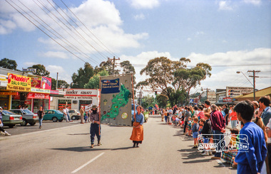
Photograph, Eltham Festival, 11 November 1989, 11/11/1989
... of authenticity, a present day prospector, Jack Hodson was placed... of authenticity, a present day prospector, Jack Hodson was placed ...Society President, Sue Law, and Junior Vice-President Doug Orford carry the Society Banner leading the parade float. The Shire of Eltham Historical Society's parade float featured a gold mining theme - "The Eltham Goldrush" Bruce Ness assembled the float with items loaned by Warrandyte Historical Society and quite a bit of his own ingenuity. Phyllis Macdonald arranged for some of her friends from the Victorian Folk Music Club to provide appropriate musical accompaniment. To provide a level of authenticity, a present day prospector, Jack Hodson was placed in charge of the equipment on the float.Roll of 35mm colour negative film, 6 stripsFuji 100 Neltham, main road, eltham central park, eltham festival, parade, shire of eltham historical society, parade float -
 Eltham District Historical Society Inc
Photograph, Eltham Festival, 11 November 1989, 11/11/1989
... of authenticity, a present day prospector, Jack Hodson was placed... of authenticity, a present day prospector, Jack Hodson was placed ...Society President, Sue Law, and Junior Vice-President Doug Orford carry the Society Banner leading the parade float. The Shire of Eltham Historical Society's parade float featured a gold mining theme - "The Eltham Goldrush" Bruce Ness assembled the float with items loaned by Warrandyte Historical Society and quite a bit of his own ingenuity. Phyllis Macdonald arranged for some of her friends from the Victorian Folk Music Club to provide appropriate musical accompaniment. To provide a level of authenticity, a present day prospector, Jack Hodson was placed in charge of the equipment on the float.Roll of 35mm colour negative film, 6 stripsFuji 100 Neltham, main road, eltham central park, eltham festival, parade, shire of eltham historical society, parade float -
![V&A Gallery of Fashion / [by] Wilcox and Lister (eds)](/media/collectors/550653872162f11fb04854aa/items/5ed04f95dcf9cd08346bd8c0/item-media/5ed050a9dcf9cd08346be871/item-fit-380x285.jpg) Kew Historical Society Inc
Kew Historical Society IncBook, V & A Publishing, V&A Gallery of Fashion, 2016
... to the present day. This concise volume perfectly encapsulates... to the present day. This concise volume perfectly encapsulates ...EXHIBITION CATALOGUES & SPECIFIC COLLECTIONS. Spanning four centuries, the V&A's Fashion Collection is the most comprehensive in the world, housing unrivaled collections of dress,accessories, shoes and hats from the 17th century to the present day. This thoroughly revised and redesigned edition shows the collection, from rare eighteenth-century gowns and exquisite bodices to 1930s evening wear, post-war couture, and showstopping ensembles by contemporary designers. Among the designers featured are Charles Frederick Worth, Madeleine Vionnet, Coco Chanel, Cristobal Balenciaga, Christian Dior, Mary Quant, Stephen Jones, Vivienne Westwood, and Alexander McQueen.176 pages : illustrations (chiefly colour) ; 27 cm.non-fictionEXHIBITION CATALOGUES & SPECIFIC COLLECTIONS. Spanning four centuries, the V&A's Fashion Collection is the most comprehensive in the world, housing unrivaled collections of dress,accessories, shoes and hats from the 17th century to the present day. This thoroughly revised and redesigned edition shows the collection, from rare eighteenth-century gowns and exquisite bodices to 1930s evening wear, post-war couture, and showstopping ensembles by contemporary designers. Among the designers featured are Charles Frederick Worth, Madeleine Vionnet, Coco Chanel, Cristobal Balenciaga, Christian Dior, Mary Quant, Stephen Jones, Vivienne Westwood, and Alexander McQueen.fashion design - history - exhibitions., fashion - history - pictorial works., victoria and albert museum -- catalogs. -
 Melbourne Legacy
Photograph - Photo, Stamp sorting, Widows activities, 1992
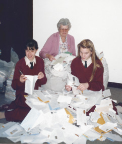
... dealer for many years to the present day. It raises some funds... dealer for many years to the present day. It raises some funds ...A group of widows gathered at Legacy House sorting stamps. Names unknown except Beryl Billings who is seated. With a group of photos about stamp sorting with post-it note "Stamp Ladies Past to 2004". The widows have sorted used stamps and sold to a stamp dealer for many years to the present day. It raises some funds and provides a purpose for gathering together. Beryl Billing was the co-ordinator for many years, she is seated at the table in this photo. The date is assumed as 1992 due to the reference number from the photographic studio 920609 means 9 June 1992.A record of the type of activities Legacy provided as a social outlet for widows and for fundraising. Black and white photo of ladies at Legacy house around Beryl Billing sorting stamps and a proof sheet.Label on the back from Keesing Photographic. Photograph reference no. 920609B-8 Yellow post-it note "Stamp Ladies Past to 2004"widows, widows club, stamps, fundraising, activities -
 Warrnambool and District Historical Society Inc.
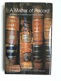
Book, A Matter of Record, 2003
... Public Records Act to the present day institution at North... Public Records Act to the present day institution at North ...This book gives the history of the Public Record Office, Victoria. It was written by Professor Bill Russell and produced in 2003. The research by Charlie Farrugia that enabled the book to be written was carried out entirely using the Public Record Office archives. The book documents the 1903 beginnings of the Public Record Office from a small collection in the possession of the Melbourne Public Library through to the important 1973 Victorian Public Records Act to the present day institution at North Melbourne. The Melbourne Public Library, the Historical Society of Victoria and the History School of the University of Melbourne were early contributors to the preservation of Victoria’s archives. This book is in the library of the Warrnambool and District Historical Society and is an important reference for us in regard to the history of archival preservation of historical documents in our State. In addition we are a Place of Deposit for historical records that are surplus to the requirements of the Public Record Office of Victoria and that concern more directly the history of Warrnambool and district. Many local Warrnambool and district residents use the facilities at the Public Record Office at North Melbourne and the link between that institution and Warrnambool historical groups is important. This is a hard cover book of 227 pages. The cover is black with gold lettering on the spine. The dust cover is dark red with printed material about the author and the book’s contents. The front of the dust cover has an illustration of four Victorian Railways ledgers in sepia tones and the back of the dust cover has a small illustration in brown and white of a heritage label. The book has a Contents page, an Acknowledgement page, a Foreword, an Introduction, eight chapters, Appendices, Notes and References and an Index. The book is a 2003 history of the Public Record Office of Victoria written by Professor Bill Russell and researched by Charlie Farrugia. Front Cover: ‘A Matter of Record, A History of Public Record Office Victoria by Professor E W (Bill) Russell, Original archival research by Charlie Farrugia.’ Spine: ‘A Matter of Record, Russell, Public Record Office Victoria’. public record office, professor bill russell, charlie farrugia, historical records of victoria -
 Warrnambool and District Historical Society Inc.
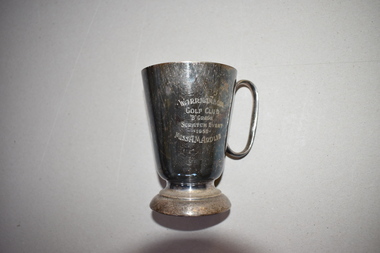
Golf Club Trophy, 1950
... present day course in what was once part of the old Western... at Albert Park until 1929 when it shifted to its present day course ...This item comes from the estate of Dorothy and Agnes Ardlie of Warrnambool. Dorothy Ardlie (1910-1993) and Agnes Ardlie (1915-1993) were the daughters of Arthur and Ethel Ardlie of Warrnambool, the granddaughters of the prominent Warrnambool lawyer, William Ardlie and his wife Mary and the great granddaughters of John and Mary Ardlie, pioneer settlers in Warrnambool. The trophy was won by Agnes Ardlie in 1950. The Warrnambool Golf Club was established in the late 19th century and the game was played by both men and women at Albert Park until 1929 when it shifted to its present day course in what was once part of the old Western Reserve. This trophy is of interest as a mid 20th century memento of a member of a prominent family in Warrnambool, Miss Agnes Ardlie and of the Warrnambool Golf Club.This is an electro-plated nickel silver mug with a circular base, a tapering body and a handle. It is much stained. There is an inscription on one side of the mug and a maker’s name on the base but this is not decipherable. Warrnambool Golf Club ‘B’ Grade Scratch Event 1950 Miss A.M. Ardlieardlie family, history of warrnambool -
 Eltham District Historical Society Inc
Photograph - Aerial Photograph, Landata, Eltham North, Feb. 1956
... Centred on present day 54 Kelway Crescent, Eltham North... melbourne Centred on present day 54 Kelway Crescent, Eltham North ...Centred on present day 54 Kelway Crescent, Eltham North bounded by Glen Gully Road to north, Meruka Drive to south, Eltham College to east and Leach Street to west. Historic Aerial Imagery Source: Landata.vic.gov.au Aerial Photo Details: Project No :250 Project : MELBOURNE OUTER SUBURBS PROJECT Run : 17 Frame : 113 Date : 02/1956 Film Type : B/W Camera : EAG9 Flying Height : 10000 Scale : 12000 Film Number : 1176 GDA2020 : 37°42'16"S, 145°08'08"E MGA2020 : 335650, 5825336 (55) Melways : 21 G2 (ed. 42)aerial photo, 1956-02, eltham, eltham north, glen gully road, leach street, main road, melway 21g2, meruka drive, montmorency, neil webster collection -
 Eltham District Historical Society Inc
Photograph - Aerial Photograph, Landata, Montmorency, Feb. 1956
... Centred on present day Tahlee Place Reserve and Sherbourne... melbourne Centred on present day Tahlee Place Reserve and Sherbourne ...Centred on present day Tahlee Place Reserve and Sherbourne Preschool, Montmorency bounded by Progress Road to north, Withers Way to south, Main Road to east and Leach Street to west. Historic Aerial Imagery Source: Landata.vic.gov.au Aerial Photo Details: Project No :250 Project : MELBOURNE OUTER SUBURBS PROJECT Run : 17 Frame : 114 Date : 02/1956 Film Type : B/W Camera : EAG9 Flying Height : 10000 Scale : 12000 Film Number : 1176 GDA2020 : 37°42'50"S, 145°08'02"E MGA2020 : 335512, 5824286 (55) Melways : 21 F5 (ed. 42)aerial photo, 1956-02, neil webster collection, central park, eltham, leach street, main road, melway 21f5, montmorency, progress road, withers way, sherbourne preschool, tahlee place reserve -
 Eltham District Historical Society Inc
Photograph - Aerial Photograph, Landata, Lower Plenty, Feb. 1956
... Centred on present day 217 Old Eltham Road, Lower Plenty... melbourne Centred on present day 217 Old Eltham Road, Lower Plenty ...Centred on present day 217 Old Eltham Road, Lower Plenty bounded by Pitt Street to north, Yarra River to south, Main Road to east and Bonds Road to west. Historic Aerial Imagery Source: Landata.vic.gov.au Aerial Photo Details: Project No :250 Project : MELBOURNE OUTER SUBURBS PROJECT Run : 17 Frame : 116 Date : 02/1956 Film Type : B/W Camera : EAG9 Flying Height : 10000 Scale : 12000 Film Number : 1176 GDA2020 : 37°43'58"S, 145°07'49"E MGA2020 : 335237, 5822186 (55) Melways : 21 E10 (ed. 42)aerial photo, 1956-02, neil webster collection, eltham, main road, bonds road, elham, lower plenty, melway 21e10, pitt street, yarra river -
 Eltham District Historical Society Inc
Photograph - Aerial Photograph, Landata, Eltham, Feb. 1956
... Centred on present day Shalbury Avenue, Eltham bounded... melbourne Centred on present day Shalbury Avenue, Eltham bounded ...Centred on present day Shalbury Avenue, Eltham bounded by Leane Drive and Parsons Road to north, Nyora Road to south, Reynolds Road to east and the Diamond Creek to west Historic Aerial Imagery Source: Landata.vic.gov.au Aerial Photo Details: Project No :250 Project : MELBOURNE OUTER SUBURBS PROJECT Run : 18 Frame : 95 Date : 02/1956 Film Type : B/W Camera : EAG9 Flying Height : 10000 Scale : 12000 Film Number : 1176 GDA2020 : 37°41'57"S, 145°09'51"E MGA2020 : 338145, 5825965 (55) Melways : 22 C1 (ed. 42)aerial photo, 1956-02, neil webster collection, eltham, diamond creek (creek), melway 22c1, nyora road, parsons road, reynolds road, shalbury avenue -
 Eltham District Historical Society Inc
Photograph - Aerial Photograph, Landata, Research, Vic, Feb. 1956
... Centred on present day Thompson Crescent, Research bounded... melbourne Centred on present day Thompson Crescent, Research bounded ...Centred on present day Thompson Crescent, Research bounded by Maroondah Aqueduct to north, Thompson Crescent and Nyora Road to south, Bells Hill Road to east and Eucalyptus Road to west Historic Aerial Imagery Source: Landata.vic.gov.au Aerial Photo Details: Project No :250 Project : MELBOURNE OUTER SUBURBS PROJECT Run : 19 Frame : 6 Date : 02/1956 Film Type : B/W Camera : EAG9 Flying Height : 10000 Scale : 12000 Film Number : 1176 GDA2020 : 37°42'38"S, 145°11'02"E MGA2020 : 339927, 5824736 (55) Melways : 22 H4 (ed. 42)aerial photo, 1956-02, neil webster collection, bells hill road, eltham, eucalyptus road, maroondah aqueduct, melway 22h4, nyora road, research (vic.), thompson crescent -
 Eltham District Historical Society Inc
Photograph - Aerial Photograph, Landata, Research, Vic, Apr. 1963
... Centred on present day Thompson Crescent and Nicholson... melbourne Centred on present day Thompson Crescent and Nicholson ...Centred on present day Thompson Crescent and Nicholson Close, Research bounded by Maroondah Aqueduct to north, Nyora Road to south, Eltham College to east and Eltham Gateway Hotel to west. Historic Aerial Imagery Source: Landata.vic.gov.au Aerial Photo Details: Project No :486 Project : MELBOURNE (1963) PROJECT Run : 5 Frame : 61 Date : 04/1963 Film Type : B/W Camera : RC8 Flying Height : 5100 Scale : 9600 Film Number : 1805 GDA2020 : 37°42'24"S, 145°10'06"E MGA2020 : 338528, 5825143 (55) Melways : 22 D3 (ed. 42)aerial photo, neil webster collection, eltham, 1963-04, eltham college, eltham gateway hotel and conference centre, maroondah aqueduct, melway 22d3, nicholson close, nyora road, research (vic.), thompson crescent -
 Eltham District Historical Society Inc
Photograph - Aerial Photograph, Landata, Eltham, Vic, Apr. 1963
... Centred on present day John Street, Eltham between Main... melbourne Centred on present day John Street, Eltham between Main ...Centred on present day John Street, Eltham between Main and Bible streets bounded by Elsa Court to north, Main Road Bridge to south, Wattle Grove to east and Bolton Street to west. Historic Aerial Imagery Source: Landata.vic.gov.au Aerial Photo Details: Project No :486 Project : MELBOURNE (1963) PROJECT Run : 6 Frame : 123 Date : 04/1963 Film Type : B/W Camera : RC8 Flying Height : 5100 Scale : 9600 Film Number : 1805 GDA2020 : 37°43'12"S, 145°08'54"E MGA2020 : 336800, 5823623 (55) Melways : 21 J6 (ed. 42)aerial photo, neil webster collection, 1963-04, bolton steet, elsa court, eltham, john street, main road, main road bridge, melway 21j6, wattle grove -
 Eltham District Historical Society Inc
Photograph - Aerial Photograph, Landata, Eltham, Vic, Apr. 1963
... Centred on present day Eltham Ridge, Bolton Street, Eltham... melbourne Centred on present day Eltham Ridge, Bolton Street, Eltham ...Centred on present day Eltham Ridge, Bolton Street, Eltham bounded by Elsa Court to north, Main Road to south, Bible Street to east and Reichelt Avenue and Rattray Road to west. Historic Aerial Imagery Source: Landata.vic.gov.au Aerial Photo Details: Project No :486 Project : MELBOURNE (1963) PROJECT Run : 6 Frame : 124 Date : 04/1963 Film Type : B/W Camera : RC8 Flying Height : 5100 Scale : 9600 Film Number : 1805 GDA2020 : 37°43'12"S, 145°08'16"E MGA2020 : 335876, 5823604 (55) Melways : 21 G6 (ed. 42)aerial photo, neil webster collection, 1963-04, bible street, bolton street, eltham, eltham ridge, main road, montmorency, rattray road, reichelt avenue -
 Eltham District Historical Society Inc
Photograph - Aerial Photograph, Landata, Eltham, Vic, Apr. 1963
... Centred on present day Griffith Park Road, Eltham bounded... melbourne Centred on present day Griffith Park Road, Eltham bounded ...Centred on present day Griffith Park Road, Eltham bounded by Mount Pleasant Road to north, Yarra River and Templestowe to south, Main Road at Reynolds Road to east and Falkiner Street to west. Historic Aerial Imagery Source: Landata.vic.gov.au Aerial Photo Details: Project No :486 Project : MELBOURNE (1963) PROJECT Run : 7 Frame : 233 Date : 04/1963 Film Type : B/W Camera : RC8 Flying Height : 5100 Scale : 9600 Film Number : 1805 GDA2020 : 37°44'04"S, 145°09'10"E MGA2020 : 337237, 5822053 (55) Melways : 22 A10 (ed. 42)aerial photo, neil webster collection, 1963-04, eltham, falkiner street, griffith park road, melway 22a10, mount pleasant road, reynolds road, templestowe, yarra river -
 Eltham District Historical Society Inc
Photograph - Aerial Photograph, Landata, Eltham, Vic, Apr. 1972
... Centred on present day Zig Zag Road near Coolabah Drive... melbourne Centred on present day Zig Zag Road near Coolabah Drive ...Centred on present day Zig Zag Road near Coolabah Drive, Eltham bounded by Allendale Road to north, Park West Road to south, Parsons Road to east and Banks Road to west. Historic Aerial Imagery Source: Landata.vic.gov.au Aerial Photo Details: Project No :985 Project : MELBOURNE 1972 Run : 26 Frame : 191 Date : 04/1972 Film Type : B/W Camera : RC10 Flying Height : 5700 Scale : 9600 Film Number : 2636 GDA2020 : 37°41'56"S, 145°09'26"E MGA2020 : 337533, 5826000 (55) Melways : 22 A1 (ed. 42)aerial photo, neil webster collection, 1972-04, allendale road, eltham, eltham north, zig zag road, banks road, coolabah drive, melway 22a1, park west road, parsons road -
 Eltham District Historical Society Inc
Photograph - Aerial Photograph, Landata, Eltham, Vic, Apr. 1972
... Centred on present day Parsons Road, Eltham bounded... melbourne Centred on present day Parsons Road, Eltham bounded ...Centred on present day Parsons Road, Eltham bounded by Allendale Road to north, Frank Street to south, Research Shops and Raglan Road to east and Zig Zag Road to west. Historic Aerial Imagery Source: Landata.vic.gov.au Aerial Photo Details: Project No :985 Project : MELBOURNE 1972 Run : 26 Frame : 192 Date : 04/1972 Film Type : B/W Camera : RC10 Flying Height : 5700 Scale : 9600 Film Number : 2636 GDA2020 : 37°42'00"S, 145°09'59"E MGA2020 : 338360, 5825897 (55) Melways : 22 D1 (ed. 42)aerial photo, neil webster collection, 1972-04, allendale road, eltham, zig zag road, frank street, melway 22d1, parsons road, raglan road, research (vic.), research shops, eltham barrel -
 Eltham District Historical Society Inc
Photograph - Aerial Photograph, Landata, Eltham, Vic, Apr. 1972
... Centred on present day Woodridge Estate, Eltham bounded... melbourne Centred on present day Woodridge Estate, Eltham bounded ...Centred on present day Woodridge Estate, Eltham bounded by Park Road to north, Mount Pleasant Road to south, Stokes Orchard Estate to east and Eltham Railway Station to west. Historic Aerial Imagery Source: Landata.vic.gov.au Aerial Photo Details: Project No :985 Project : MELBOURNE 1972 Run : 27 Frame : 46 Date : 04/1972 Film Type : B/W Camera : RC10 Flying Height : 5700 Scale : 9600 Film Number : 2636 GDA2020 : 37°42'49"S, 145°09'46"E MGA2020 : 338053, 5824365 (55) Melways : 22 C5 (ed. 42)aerial photo, neil webster collection, 1972-04, eltham, eltham railway station, melway 22c5, mount pleasant road, park road, stokes orchard estate, woodridge estate -
 Eltham District Historical Society Inc
Photograph - Aerial Photograph, Landata, Eltham, Vic, Apr. 1972
... Centred on present day Main Road at Pryor Street, Eltham... melbourne Centred on present day Main Road at Pryor Street, Eltham ...Centred on present day Main Road at Pryor Street, Eltham bounded by Park West Road to north, Napoleon Street to south, Woodridge Estate to east and Ryans Road to west. Historic Aerial Imagery Source: Landata.vic.gov.au Aerial Photo Details: Project No :985 Project : MELBOURNE 1972 Run : 27 Frame : 47 Date : 04/1972 Film Type : B/W Camera : RC10 Flying Height : 5700 Scale : 9600 Film Number : 2636 GDA2020 : 37°42'45"S, 145°09'12"E MGA2020 : 337223, 5824470 (55) Melways : 22 A4 (ed. 42)aerial photo, neil webster collection, 1972-04, eltham, eltham railway station, woodridge estate, eltham shops, main road, melway 22a4, napoleon street, park west road, pryor street, ryans road -
 Eltham District Historical Society Inc
Photograph - Aerial Photograph, Landata, Eltham, Vic, Apr. 1972
... Centred on present day Dalton Street at Mount Pleasant Road... melbourne Centred on present day Dalton Street at Mount Pleasant ...Centred on present day Dalton Street at Mount Pleasant Road, Eltham bounded by Arthur Street to north, Yarra River and Kent Hughes Road to south, Eucalyptus Road to east and Susan Street to west. Historic Aerial Imagery Source: Landata.vic.gov.au Aerial Photo Details: Project No :985 Project : MELBOURNE 1972 Run : 28 Frame : 208 Date : 04/1972 Film Type : B/W Camera : RC10 Flying Height : 5700 Scale : 9600 Film Number : 2635 GDA2020 : 37°43'29"S, 145°08'54"E MGA2020 : 336816, 5823118 (55) Melways : 21 J8 (ed. 42)aerial photo, neil webster collection, 1972-04, eltham, arthur street, dalton street, eucalyptus road, kent hughes road, melway 21j8, mount pleasant road, susan street, yarra river -
 4th/19th Prince of Wales's Light Horse Regiment Unit History Room
Domestic object - Silver tray
... , but not the ancestor, of the present day Royal Australian Armoured Corps... to be the forerunner, but not the ancestor, of the present day Royal Australian ...On 19 May 1908 authority was given for the formation of the 'Australian Volunteer Automibile Corps'. This Corps was disbanded in 1916, but during its short life it proved to be the forerunner, but not the ancestor, of the present day Royal Australian Armoured Corps. During World War 1 the first Australian armoured car despatched to the war was manned by volunteers of this Corps. On 1 July 1929 the 19th Light Horse (Yarrowee Light Horse) ceased to be maintained. In 1935 the 19th Light Horse (Armoured Car) Regiment became the 1st Armoured Car Regiment (Wimmera Regiment) forming part of the 2nd Cavalry Division with detachments at Horsham, Nhill, Dimboola, Rupanyip and Murtoa.Electroplated nickel EPNS silver tray, oblong with bowed sides. Tray patterned with concentric striations. 14.5 cm elliptical space in centre containing inscriptions. On front: "FIRST ARMOURED CAR REGT TROOP DRILL CONTEST A Sqn, B Sqn, C Sqn 1934." On back: Hallmark - G 712 6 pointed star containing "8" over boomerang. EPNS S&Snhill, 1st armoured car regiment, silverware, troop competitions -
 Melbourne Legacy
Photograph - Photo, Stamp sorting, Keesing Photographic Pty Ltd, Widows activities, 1992
... years to the present day. It raises funds and provides a purpose... years to the present day. It raises funds and provides a purpose ...A Legacy widow, Beryl Billing, with two school girls from Siena College and a lot of loose letters. Six school girls came to Legacy house to meet the weekly gathering of the stamp ladies. They had chosen Legacy as a cause they wanted to help and decided to collect stamps, they donated over 5,000 stamps. The widows clubs have sorted used stamps and sold to a stamp dealer for many years to the present day. It raises funds and provides a purpose for gathering together. Beryl Billings was the co-ordinator of the stamp sorting for many years. This photo was featured on the back cover of The Answer newsletter in September 1992.A record of the type of activities Legacy provided as a social outlet for widows and for fundraising. Colour photo of Beryl Billing with two school girls and bags of letters.Hand written "A / Pg 20 / Crop top" in blue penwidows, fundraising, answer, stamps, beryl billing -
 Melbourne Legacy
Photograph - Photo, Stamp sorting, Widows activities
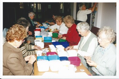
... to a stamp dealer for many years to the present day. It raises some... dealer for many years to the present day. It raises some funds ...A group of widows gathered at Legacy House sorting stamps. Same film as 00603. Beryl Billing who was the co-ordinator of stamp sorting for many years, is seen standing in two of the photos in the white top. Other names unknown. Beryl would write reports for the Answer asking for stamps and reporting the sum of money raised. From 1981 to 1995 they raised over $78,000. With a group of photos about stamp sorting with post-it note "Stamp Ladies Past to 2004". The widows have sorted used stamps and sold to a stamp dealer for many years to the present day. It raises some funds and provides a purpose for gathering together.A record of the type of activities Legacy provided as a social outlet for widows and for fundraising. Colour photo x 3 of ladies at Legacy House sorting stamps.Printing on the back "widows, stamps, beryl billings, answer, fundraising -
 Eltham District Historical Society Inc
Photograph, Doney's General Store, Research, c.1969
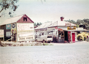
... at the head of the present day Research shops on Main Road near... at the head of the present day Research shops on Main Road near ...Roadside buildings, formerly Doney's General Store. Doney's operated from the 1880s through to the late 1960s. It was situated at the head of the present day Research shops on Main Road near the corner of Raglan Road. By the 1960s it was under new ownership. The Store had a residence at the back. Signs promote The Herald and Sun newspapers, four 'n twenty pies, coca cola and more. A public phone box is in the front of the store. Beside the store is possibly an old farm building with more signs advertising honey, Streets, Tarax and a local bottle dump. Lyn Dodkins used to work in the Store after school.Digital file onlygeneral store, research (vic.), milkbar, lyn dodkins -
 Eltham District Historical Society Inc
Photograph - Aerial Photograph, Landata, Montmorency, Feb. 1956
... Centred on present day Grand Boulevard and Olympic Way... melbourne Centred on present day Grand Boulevard and Olympic Way ...Centred on present day Grand Boulevard and Olympic Way, Montmorency bounded by Diamond Street to north, Old Eltham Road and Eltham Lower Park to south, Bible Street to east and Para Road to west. Historic Aerial Imagery Source: Landata.vic.gov.au Aerial Photo Details: Project No :250 Project : MELBOURNE OUTER SUBURBS PROJECT Run : 17 Frame : 115 Date : 02/1956 Film Type : B/W Camera : EAG9 Flying Height : 10000 Scale : 12000 Film Number : 1176 GDA2020 : 37°43'24"S, 145°07'55"E MGA2020 : 335375, 5823236 (55) Melways : 21 F7 (ed. 42)aerial photo, 1956-02, neil webster collection, eltham, main road, montmorency, bible street, diamond street, eltham lower park, grand boulevard, melway 21f7, old eltham road, olympic way, para road -
 Eltham District Historical Society Inc
Photograph - Aerial Photograph, Landata, Eltham, Feb. 1956
... Centred on present day Mount Plaeasant Road near Dalton... melbourne Centred on present day Mount Plaeasant Road near Dalton ...Centred on present day Mount Plaeasant Road near Dalton Street, Eltham bounded by Luck Street to north, Eltham Lower Park to south, Reynolds Road to east and Central Park to west Historic Aerial Imagery Source: Landata.vic.gov.au Aerial Photo Details: Project No :250 Project : MELBOURNE OUTER SUBURBS PROJECT Run : 18 Frame : 93 Date : 02/1956 Film Type : B/W Camera : EAG9 Flying Height : 10000 Scale : 12000 Film Number : 1176 GDA2020 : 37°43'02"S, 145°09'38"E MGA2020 : 337871, 5823961 (55) Melways : 22 B6 (ed. 42)aerial photo, 1956-02, neil webster collection, eltham, central park, eltham lower park, luck street, melway 22b6, nyora road, reynolds road, dalton street, mount pleasant road -
 Eltham District Historical Society Inc
Photograph - Aerial Photograph, Landata, Eltham, Vic, Feb. 1956
... Centred on present day Parsons Avenue at Leane Drive near... melbourne Centred on present day Parsons Avenue at Leane Drive near ...Centred on present day Parsons Avenue at Leane Drive near the Maroondah Aqueduct, Eltham bounded by Lorimer Road to north, Thompson Crescent and Norman Road to south, Bells Hill Road to east and Parsons Road to west Historic Aerial Imagery Source: Landata.vic.gov.au Aerial Photo Details: Project No :250 Project : MELBOURNE OUTER SUBURBS PROJECT Run : 19 Frame : 5 Date : 02/1956 Film Type : B/W Camera : EAG9 Flying Height : 10000 Scale : 12000 Film Number : 1176 GDA2020 : 37°42'04"S, 145°11'09"E MGA2020 : 340064, 5825786 (55) Melways : 22 H1 (ed. 42)aerial photo, 1956-02, neil webster collection, allendale road, bells hill road, eltham, leane drive, lorimer road, maroondah aqueduct, melway 22h1, norman road, parsons road, research (vic.), thompson crescent -
 Eltham District Historical Society Inc
Photograph - Aerial Photograph, Landata, Eltham, Vic, Apr. 1963
... Centred on present day Zig Zag Road and Main Road, Eltham... melbourne Centred on present day Zig Zag Road and Main Road, Eltham ...Centred on present day Zig Zag Road and Main Road, Eltham bounded by Maroondah Aqueduct to north, Thompson Crescent and Arthur Street to south, Parsons Road to east and Glen Park Road and Banks Road to west. Historic Aerial Imagery Source: Landata.vic.gov.au Aerial Photo Details: Project No :486 Project : MELBOURNE (1963) PROJECT Run : 5 Frame : 59 Date : 04/1963 Film Type : B/W Camera : RC8 Flying Height : 5100 Scale : 9600 Film Number : 1805 GDA2020 : 37°42'24"S, 145°08'52"E MGA2020 : 336716, 5825114 (55) Melways : 21 J3 (ed. 42)aerial photo, neil webster collection, eltham, 1963-04, arthur street, banks road, glen park road, maroondah aqueduct, melway 21j3, parsons road -
 Eltham District Historical Society Inc
Photograph - Aerial Photograph, Landata, Eltham, Vic, Apr. 1963
... Centred on present day Floriston Grove, Eltham bounded... melbourne Centred on present day Floriston Grove, Eltham bounded ...Centred on present day Floriston Grove, Eltham bounded by Maroondah Aqueduct to north, Thompson Crescent and Diosma Road to south, Research Shops to east and Glen Park Road and Park West Road to west. Historic Aerial Imagery Source: Landata.vic.gov.au Aerial Photo Details: Project No :486 Project : MELBOURNE (1963) PROJECT Run : 5 Frame : 60 Date : 04/1963 Film Type : B/W Camera : RC8 Flying Height : 5100 Scale : 9600 Film Number : 1805 GDA2020 : 37°42'24"S, 145°09'29"E MGA2020 : 337622, 5825128 (55) Melways : 22 B3 (ed. 42)aerial photo, neil webster collection, eltham, 1963-04, diosma road, floriston grove, maroondah aqueduct, melway 22b3, park west road, research (vic.), research shops -
 Eltham District Historical Society Inc
Photograph - Aerial Photograph, Landata, Lower Plenty, Vic, Apr. 1963
... Centred on present day Old Eltham Road near Araluen Centre... melbourne Centred on present day Old Eltham Road near Araluen Centre ...Centred on present day Old Eltham Road near Araluen Centre, Lower Plenty bounded by Cromwell Street to north, Yarra River to south, Main Road at Mount Pleasant Road to east and Panorama Avenue to west. Historic Aerial Imagery Source: Landata.vic.gov.au Aerial Photo Details: Project No :486 Project : MELBOURNE (1963) PROJECT Run : 7 Frame : 231 Date : 04/1963 Film Type : B/W Camera : RC8 Flying Height : 5100 Scale : 9600 Film Number : 1805 GDA2020 : 37°44'03"S, 145°07'56"E MGA2020 : 335420, 5822027 (55) Melways : 21 F10 (ed. 42)aerial photo, neil webster collection, 1963-04, araluen, cromwell street, eltham, lower plenty, main road, melway 21f10, mount pleasant road, old eltham road, panorama avenue, yarra river