Showing 436 items
matching victoria hill area
-
 Surrey Hills Historical Society Collection
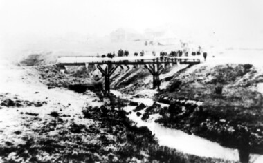
Photograph, Opening of the footbridge across Back Creek, 1936, 1936
This photo was taken at the opening of the footbridge over Back Creek by Sir Winston Dugan, Governor of Victoria, in 1936. He is cutting bunting draped along the bridge rails. South Surrey Park was developed on land which had been the property of the Kleinert family. Their land extended from Union Road to Essex Road. They ran horses, ducks and fowls and Emily Kleinert grew flowers. Alan Holt research: Lot 6 was sold to Martin Klienert by Karl Richter in 1860 together with a portion of another adjacent lot. From 1860-1885 Martin worked it as a market garden leasing some land for grazing when it was not required for gardening. He died in 1898. In a formal document, William declared he was the son of Martin "who purchased land in 1860, died in 1898 and the land has been continually occupied by father and family since. It has been cultivated as a market garden; when not being used for gardening it was let for cultivation and grazing." William died in 1939 and the property passed to his sons Martin and Ernest. The family sold the land to the Camberwell Council in the 1950s.This photo is significant as it documents the change from rural to urban land use in the area.Black and white photo taken at the opening of the footbridge across Back Creek in the area later known as South Surrey Park. Back Creek runs diagonally through the photo with a wooden footbridge prominent. Dignitaries are gathered on the bridge. A tent and houses can just be distinguished in the background.parks and reserves, creeks, south surrey park, civic occasion, official events, back creek, verdun street, footbridges, governor of victoria, sir winston duggan, surrey hills, kleinert family, (mr) karl richter, (mr) martin kleinert, topography -
 Stawell Historical Society Inc
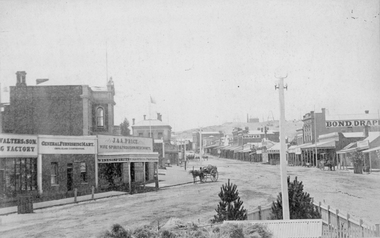
Photograph, Main Street Stawell looking East from the Present War Memorial site 1878
Main St. looking East towards Big Hill from Coffee Palace Verandah over Present War Memorial area. 1878 Businesses from left Walters and Son Factory, General Furnishing Mart, Stawell Town Hall, J. & A. Price Wine Spirits & Provision Merchants, Stawell Post Office. On right south side of Main Street, two-storey wooden Bull & Mouth Hotel, Whiteside Taylors, Carters Boot shop, Lecky Draper, C. Mulcahy Post Office Hotel, G.J. Hewlett Baker & Confectionery, Iron Monger, Victoria House Bond Draper, Town Hall Hotel, J. Richards Fancy Repository. Victorian Views. C. Herbert, Photo. Stawell 1878stawell business streetscape -
 Surrey Hills Historical Society Collection
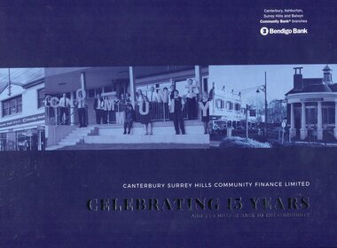
Book, Canterbury Surrey Hills Community Finance Limited: Celebrating 15 Years and $5.6 Million back to the community, 2018
This book celebrates the achievements of the Bendigo Community Bank after 15 years in Surrey Hills and Canterbury. The Surrey Hills branch was opened in the bank site previously operated by the CBA (Commonwealth Bank of Australia) after it took over the State Savings Bank of Victoria (SSB) which has the building constructed for bank use in 1916. A public meeting to garner support for opening a branch of the Bendigo Community Bank was held in the Surrey Hills Neighbourhood Centre. One of those pushing for restoration of banking services in the area was Damien Hudson, son of real estate agent Ray Hudson. He subsequently became a member of the Surrey Hills Community Bank Board. Dick Menting, who was the local Councillor at the time, was another key supporter who likewise became a board member as did Bob Stensholt, the MLA for Burwood .Hard covered book, H 23.2 cm , 71 pages, incl index(ms) jennifer flynn, bendigo bank, canterbury surrey hills community finance, community banking, (mr) damien hudson, (cr) dick menting, (mr) bob stensholt -
 Surrey Hills Historical Society Collection
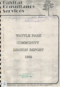
Book, Habitat Consulting Services, Wattle Park Community Liaison Report 1989, Sept 1989
The role of the community consultation officer was to act as an interface between Board of Works and the community. This is a report on the outcome of feedback re: the various areas of Wattle Park, including the natural environment, the constructed environment and the restoration projects of different areas of the park.Five major issues were identified: disability and elderly access to the park; staffing; dogs; security of parkland and personal safety; green issues.A spiral bound photocopy of a report."Property of Surrey Hills Historical Society (Historical Society crossed out) / Heritage Group" (in Jocelyn Hall's handwriting)wattle park, jeanette norman, m m board of works, parks and recreation, wattle park advisory committee, bird observers club of victoria, wattle park golf club, 4 seasons tennis club, golf, wattle park chalet, doberman club of victoria, melbourne and metropolitan tramways band, surrey hills neighbourhood centre, residents action group of box hill south, (ms) faye shepherd -
 Surrey Hills Historical Society Collection
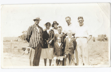
Photograph, Subdivision sale of Black's Mont Albert farm in 1924, 1924
Photo was taken in 1924 when the land was subdivided. Black's dairy farm occupied the area just east of Hamilton Street to near Elgar Road. It was subdivided into 88 house allotments along Churchill Street, Bruce Street, Black Street, Proudfoot Street and View Street. The solicitors were Proudfoot & Horton, 360 Collins Street; estate agents were Duncan & Weller, 29 Queen Street. The real estate subdivision notice on the SLV website states that Neil Black had been the owner for 50 years. To date no trace of a Neil Black has been found. Box Hill rate books simply give BLACK as the owner in 1877 (no first name); the entry for 1878-1884 states Robert Black. The 1909 electoral roll has entries for Mont Albert Road for Robert Black (farmer), Thomas Black (carter) & Elizabeth Black (HD). The 1912 electoral roll has entries for Mont Albert Road for Robert Black (farmer), Thomas Black (labourer), John Arthur Black (carter) & Elizabeth Black (HD). Robert Black died in 1920 (b. 1836) and is buried in Box Hill Cemetery (CE-*-0057). His parents were John and Margaret Black. He married Lizzie Foley in 1878. She was the daughter of Margaret & John Foley, born in 1859. She died in 1902 aged 43 years and is buried in the same grave, although the cemetery records record her age as 0 years (presumably as no age or date of birth were given at the time of burial). Children: 1. James Hughbert (1880-1954) 2. John Arthur (1881-1959) 3. Alice (1882-1883) - died aged 6 months 4. Laura Elizabeth (1883-1951) 5. Thomas (1885-1965) 6. Isabella (1887-1963) 7. Eleanor (1889-1963) 8. Ada Maud (1890-1968) 9. Robert (1892-1930). BDM Victoria states places of birth as Box Hill, Surrey Hills or Mont Albert. Many of the family are buried in Box Hill Cemetery. None of the girls appear to have married. Communication from a descendant of John Arthur Black gives the following: "John Arthur Black, son of Robert & Lizzie Foley, married Gladys Anne Layton had 4 children, Robert, Elenore, Marion (Follett) & Annie; they had farm on Stud Road, Dandenong where they milked 30 cows that he retired to after being a earth-moving contractor with draft horses and dug irrigation ditches around Shepparton." This is important as documentation of the area's transformation from farming land to residential land use.Black and white photo of a large 3-poled tent in an area of flat land with eucalypts in the background. There is a large crowd of people, mainly men but also women and children. There are also 3 cars to the RHS.black's dairy farm, dairying, farms, churchill street, black street, proudfoot street, bruce street, view street, neil black, proudfoot & horton, duncan & weller, robert black, lizzie black, lizzie foley, james hubert black, john arthur black, alice black, laura elizabeth black, thomas black, isabella black, eleanor black, ada maud black, robert black jnr, box hill cemetery, land sales -
 Surrey Hills Historical Society Collection
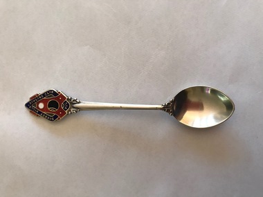
Souvenir - Souvenir teaspoon, Twentieth Century
James Albon is credited with building the first bowling green in Surrey Hills at his home on the corner of Mont Albert Road and Wilson Street (later occupied by the Roman Catholic convent). This green was so popular with his friends that he organised the formation of a bowling club at the corner of Montrose and Wilson Streets. It opened in 1912. Earliest club records date from 1916. The original club-house was rebuilt in 1922/23 using interlocking blocks as recommended by Walter Burley-Griffin. This was quite an innovative design at the time. In turn cream brick buildings replaced this building in the 1950s. The Surrey Hills Bowls Club disbanded in 1995. The donor believed that this spoon belong to her grandfather David Miller (Dave) Mair who lived at 20 Barton Street until his death in 1938. Dave was an extremely keen sportsman (particularly bowls and cricket). He started the Kangaroo Cricket Club and worked for the Melbourne Cricket Club. She initially sent the spoon to the Surrey Hills Bowling Club in 1996, not realising that it had closed the previous year. It was returned to her and over 20 years later was donated to this collection. This is part of a large donation of material relating to the Deakin, Mair and Young families, all with connections to the Surrey Hills and Mont Albert area. This augments other material relating to the history of the Surrey Hills Bowling Club that was saved by Jocelyn and Ken Hall after the club closed in 1995. The official records of the club were deposited with the State Library of Victoria, but prior to this some summary notes were made by the Halls. The material is evidence of one of the earliest sporting clubs established in the area.An EPNS metal teaspoon, consisting of a curved bowl with a decorative plaque at the top of the handle. On the front of this is an image of a lawn bowls ball and a jack within a scroll and linked with a band containing the words "SURREY HILLS BOWLING CLUB VIC". The plaque is inlaid in red, navy, white and black enamel. The makers name is impressed into the back of the handle.Rear: "Paramount" / "E.P.N.S."surrey hills bowling club, souvenir spoons, david miller mair, dave mair, laurie young, laurie newton -
 Surrey Hills Historical Society Collection
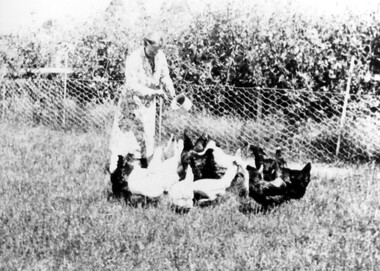
Photograph, Mrs Jessie Crow feeding fowls
The property is identified as 'Strathmore', the home of Joseph Sutton Crow and his wife Winifred (Jessie) Temby, whom he married in 1910. Joseph Sutton Crow: (1881-1969) - Joseph Sutton Crow gained his Diploma of Music from the Marshall Hall Conservatorium, the forerunner to the Melbourne University Conservatorium, in 1907. He taught both piano and organ and was organist and choirmaster in several churches. However it was as a fine administrator that Sutton Crow made a significant contribution to music in Melbourne. From 1910-1920 he was Secretary and Librarian of the Music Department at the University of Melbourne and from 1920 was the Secretary and Assistant Director of the Conservatorium of Music. From 1919 he was also Secretary of the Australian Music Examinations Board. He married lyric soprano, Jessie Temby and moved to ‘Strathmore’, 75 Victoria Crescent, Mont Albert in 1924 and lived there until 1952. In c1926 he was one of those behind establishing the public appeal to raise a million shillings to go towards the establishment of a permanent Symphony Orchestra. The appeal successfully raised both £4000 and the profile of orchestral music in Melbourne. The result was the Melbourne University Symphony Orchestra, which later became the Melbourne Symphony Orchestra, and from 1926-1939 he was its manager. Close local musical contemporaries were violinist Stanislau de Tarczynski and pianist Edward Goll, both of whom lived in Mont Albert. Winifred Jessie Temby (1883 - 1968) - soprano The donor was their daughter.A black and white photograph of a lady holding a sauce pan in her left hand and ladling out food to the fowls in front of her. Behind her there is a fenced off area with trees behind it.'strathmore', house names, victoria crescent, mont albert, surrey hills, joseph sutton crow (mr), winifred jessie temby (miss), jessie tremby (miss), winifred jessie crow (mrs), jessie crow (mrs), orchards, jean crow (miss) -
 Surrey Hills Historical Society Collection
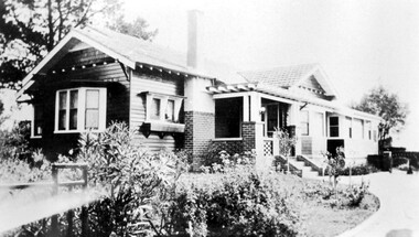
Photograph, 'Strathmore' 75 Victoria Crescent, Mont Albert
‘Strathmore’ Victoria Crescent (dem.) Joseph Sutton Crow and his wife Jessie (nee Temby) bought this property which had belonged to the Purbrick family in 1924. Sutton was an amateur ‘planner and landscape designer’ and had much pleasure in planning the use of their garden of 100 feet by 400 feet. While part remained rural with sheep, an orchard and vegetable garden, he laid out sweeping designs for the front garden which Jessie enjoyed converting into a garden worthy of display and which did gain prizes in the Herald Garden competitions of the 1930s. They entertained friends and often had as guests University Conservatorium staff and visiting musical personnel. They also opened the garden for local church fund-raising functions. Children, Jean and Ray, had areas set out for their recreation with pets and activities areas. The donor was their daughter. A black and white photograph of a Californian Style weatherboard house, painted in a dark colour. There is a well established garden in front. There is a bay window at one side of the house.house names, californian bungalow style, weatherboard, victoria crescent, surrey hills, (mr) joseph sutton crow, (mrs) jessie sutton crow, purbrick family, 1924, herald garden competitions, 1930-1939, (miss) jean sutton crow, (mr) ray sutton crow, 'strathmore' -
 Surrey Hills Historical Society Collection
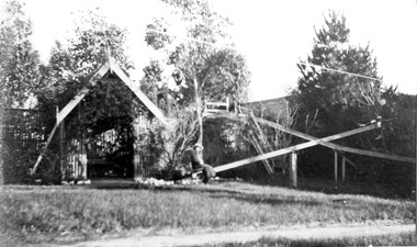
Work on paper - Photograph, Playground at "Graceburn" 9 Victoria Crescent Surrey Hills, c1909-10
Joseph Bailey built an elaborate playground for his children, as illustrated by this high slide and long see-saw. They were not allowed to play on this equipment on a Sunday. The name 'Graceburn' came from the area in Healesville where the Bailey family came from. The Bailey family were members of the Wyclif Congregational Church. (Ref: Letter from donor dated 26/4/2002.A black and white photograph of two people on a seesaw in a garden setting. There is a long slide in the background.surrey hills, victoria crescent, mr joseph bailey, seesaws, slides, playgrounds, graceburn, house names -
 Surrey Hills Historical Society Collection
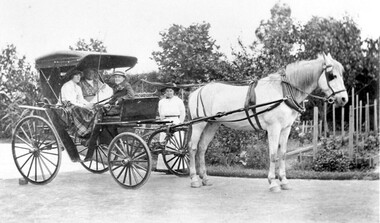
Work on paper - Photograph, "Graceburn" 9 Victoria Crescent Surrey Hills. The Bailey family leavng for an outing in their buggy, c1915
Taken outside ‘Graceburn’, 9 Victoria Crescent. The name 'Graceburn' came from the area in Healesville where the Bailey family came from. The Bailey family were members of the Wyclif Congregational Church. (Ref: Letter from donor dated 26/4/2002.A black and white photograph of a horse and buggy with three people sitting in the buggy and one lady standing beside it. There is a well established garden in the background.surrey hills, victoria crescent, miss florence bailey, graceburn, house names, buggies, horse drawn vehicles, carriage and coaches, horses, clothing and dress -
 Surrey Hills Historical Society Collection
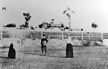
Photograph, Surrey Hills Golf Club eighth hole, 1902, 1902
Reproduced by permission of Mr John Arnold from his book: "The Riversdale Golf Club - a history, 1892-1977." Copyright to book: Riversdale Golf Club. Surrey Hills Golf Club operated from 1892-1908 then moved and became Riversdale Golf Club. The game was played across paddocks from Trafalgar Street, Mont Albert to Whitehorse Road and down Victoria Crescent to where Box Hill TAFE is now located in Elgar Road. There were problems with cows eating the tee flags! The clubhouse still exists as 30 Trafalgar Street. No 3 Beatty Street is in the background. The players are probably standing on what is now Zetland Road.This image is important not only for documentation of early sporting activities in the area but also for evidence of the pre-urban appearance of the landscape.Black and white photo with 2 ladies with golf clubs in the foreground and a lad (? caddy) with a golf bag under his arm. He is wearing a cap and 'plus fours'. The ladies are wearing long skirts, blouses and hats. Behind is a post-and-rail fence with a house and trees in the background.Caption: " Bottom: Putting out on the eighth hole, 1902."sports grounds, surrey hills golf club, riversdale golf club, clothing and dress, zetland road, surrey hills, john arnold -
 Surrey Hills Historical Society Collection
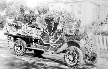
Photograph, Armitstead Woodyard truck decorated for Empire Day, mid-1930s, 1930
Date is approximate. Donor's connection with Armitstead's Woodyard was that Frank Foley was a long term employee. The Empire Day movement was instituted in England in 1904 and on 24 May 1906 a group of Surrey Hills residents pledged to make Empire Day a success. From 1932-1938 large Empire Day celebrations were held in Surrey Hills and business and commercial vehicles were decorated to take part in large processions held in May each year. These attracted large crowds from all over Melbourne. The truck is parked outside Nethercourt Hospital at 15 Barton Street. The Armitstead family had a business in Union Road which supplied wood in winter and ice in summer. Photos such as this one are evidence of the importance once attached to celebrating Empire Day, which was held on 24 May (Queen Victoria’s birthday). From 1905, a range of patriotic activities across Australia were performed on this day. There was a focus on schoolchildren, who were given a half-holiday, and the occasion was often highlighted with bonfires and fireworks in the evening - in this area at Beckett Park. The parade down Union Road was famous throughout Melbourne and attracted large crowds. Floats in the parade were often decked with British flags. The pro-Empire sentiment in the Surrey Hills area in part reflected the background and strong ties of many families.Black and white photo of a delivery truck with bunting and ferns over the cabin and back. The wheels have straws around the rims and more foliage is on the cabin roof and bonnet. The back of the tray is up and boxes, foliage and possibly a lion's head decorate the tray. Behind is a 2 storey (?) rendered building with an external timber staircase broken in 2 by a landing. The house sits behind a simple picket fence.On the cabin door of the truck: "S ARMITS ....[remainder in shadow] / Surrey Hills / phone 10X1816 / [undecipherable]" On back of the original in pencil in top centre left "446a" in Jocelyn Hall's handwriting; centre on a piece of paper stuck on with tape "Mrs D Foley / 39 Sunbury Cres., / Surrey Hills / Phone 8301163".empire day, festival and celebrations, woodyard, parades, processions, hospitals, nethercourt hospital, stephen godfrey armitstead, frank foley, mrs d foley, barton street -
 Surrey Hills Historical Society Collection
Photograph, Opening of the footbridge across Back Creek, 1936, 1936
This photo was taken at the opening of the footbridge over Back Creek by Sir Winston Dugan, Governor of Victoria, in 1936. He is cutting bunting draped along the bridge rails. South Surrey Park was developed on land which had been the property of the Kleinert family. Their land extended from Union Road to Essex Road. They ran horses, ducks and fowls and Emily Kleinert grew flowers. Alan Holt research: Lot 6 was sold to Martin Klienert by Karl Richter in 1860 together with a portion of another adjacent lot. From 1860-1885 Martin worked it as a market garden leasing some land for grazing when it was not required for gardening. He died in 1898. In a formal document, William declared he was the son of Martin "who purchased land in 1860, died in 1898 and the land has been continually occupied by father and family since. It has been cultivated as a market garden; when not being used for gardening it was let for cultivation and grazing." William died in 1939 and the property passed to his sons Martin and Ernest. The family sold the land to the Camberwell Council in the 1950s.This photo is significant as it documents the change from rural to urban land use in the area.Black and white photo taken at the opening of the footbridge across Back Creek in the area later known as South Surrey Park. Back Creek runs diagonally through the photo with a wooden footbridge prominent. Dignitaries are gathered on the bridge. A tent and houses can just be distinguished in the background.parks and reserves, creeks, south surrey park, civic occasion, official events, back creek, verdun street, footbridges, governor of victoria, sir winston duggan, surrey hills, kleinert family, (mr) karl richter, (mr) martin kleinert, topography -
 Surrey Hills Historical Society Collection
Photograph, Streetscape near the corner of Victoria Crescent and Hotham Street, Surrey Hills
Prior to subdivision for housing this area was paddocks used for grazing of cattle and used as part of the course in the early days of the Surrey Hills Golf Club. Reproduced by permission of Mr John Arnold from his book: "The Riversdale Golf Club - a history, 1892-1977." Copyright to book: Riversdale Golf Club. Surrey Hills Golf Club operated from 1892-1908 then moved and became Riversdale Golf Club. The game was played across paddocks from Trafalgar Street, Mont Albert to Whitehorse Road and down Victoria Crescent to where Box Hill TAFE is now located in Elgar Road. There were problems with cows eating the tee flags! The clubhouse still exists as 30 Trafalgar Street.Black and white photo taken from the centre of a bitumen road which is flanked by bluestone guttering. Nature strips, drive cross-overs and house fences are shown. Trees on the RHS nature strip are pollarded to avoid overhead power and telephone lines. There houses in the background."Bottom: The same view today taken from the intersection of Victoria Crescent and Hotham Street, Surrey Hills."surrey hills golf club, hotham street, victoria crescent, riversdale golf club, surrey hills, john arnold -
 Surrey Hills Historical Society Collection
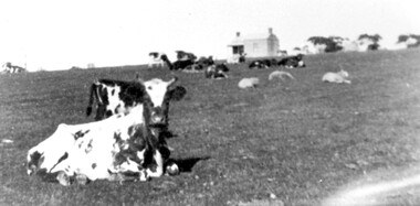
Photograph, Norman Carter, Part of Black's dairy farm in Mont Albert in the 1920s, 1920s
Photo is likely to have been taken pre-1924 when the land was subdivided. Donor information is that this was taken from a home in Churchill Street, Mont Albert; it would be looking south towards Mont Albert Road. Black's dairy farm occupied the area just east of Hamilton Street to near Elgar Road. It was subdivided into 88 house allotments along Churchill Street, Bruce Street, Black Street, Proudfoot Street and View Street. The solicitors were Proudfoot & Horton, 360 Collins Street; estate agents were Duncan & Weller, 29 Queen Street. The real estate subdivision notice on the SLV website states that Neil Black had been the owner for 50 years. To date no trace of a Neil Black has been found. Box Hill rate books simply give BLACK as the owner in 1877 (no first name); the entry for 1878-1884 states Robert Black. The 1909 electoral roll has entries for Mont Albert Road for Robert Black (farmer), Thomas Black (carter) & Elizabeth Black (HD). The 1912 electoral roll has entries for Mont Albert Road for Robert Black (farmer), Thomas Black (labourer), John Arthur Black (carter) & Elizabeth Black (HD). Robert Black died in 1920 (b. 1836) and is buried in Box Hill Cemetery (CE-*-0057). His parents were John and Margaret Black. He married Lizzie Foley in 1878. She was the daughter of Margaret & John Foley, born in 1859. She died in 1902 aged 43 years and is probably buried in the same grave, although the cemetery records record her age as 0 years. Children: 1. James Hughbert (1880-1954) 2. John Arthur (1881-1959) 3. Alice (1882-1883) - died aged 6 months 4. Laura Elizabeth (1883-1951) 5. Thomas (1885-1965) 6. Isabella (1887-1963) 7. Eleanor (1889-1963) 8. Ada Maud (1890-1968) 9. Robert (1892-1930). BDM Victoria states places of birth as Box Hill, Surrey Hills or Mont Albert. Many of the family are buried in Box Hill Cemetery. None of the girls appear to have married. Communication from a descendant of John Arthur Black gives the following: "John Arthur Black, son of Robert & Lizzie Foley, married Gladys Anne Layton had 4 children, Robert, Elenore, Marion (Follett) & Annie; they had farm on Stud Road, Dandenong where they milked 30 cows that he retired to after being a earth-moving contractor with draft horses and dug irrigation ditches around Shepparton." This is important as documentation of the area's early farming land use.Black and white photo of a paddock with cows and sheep grazing. On the horizon is a simple cottage with a small veranda and 2 chimneys and scattered trees.black's dairy farm, dairying, farms, churchill street, black street, proudfoot street, bruce street, view street, neil black, proudfoot & horton, duncan & weller, robert black, lizzie black, lizzie foley, james hubert black, john arthur black, alice black, laura elizabeth black, thomas black, isabella black, eleanor black, ada maud black, robert black jnr, box hill cemetery -
 Surrey Hills Historical Society Collection
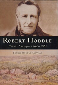
Book, Robert Hoddle: pioneer surveyor 1794-1881, 2004
(Ms) Berres Hoddle Colville is a local Surrey Hills resident and is a descendant of Robert Hoddle. Robert Hoddle was the first Surveyor General of Victoria. He arrived in Australia in 1823 and was one of the very earliest surveyors to explore, measure and map large areas of this vast, varied and difficult countryside, in a burgeoning era of pastoral settlement. 1837 saw him appointed Surveyor in Charge of the Port Phillip District. This book is based firmly on substantial extracts from Hoddle's own diary and other writings. Includes black and white sketches, maps and colour pages.Robert Hoddle was the first Surveyor General of Victoria. He arrived in Australia in 1823 and was one of the very earliest surveyors to explore, measure and map large areas of this vast, varied and difficult countryside, in a burgeoning era of pastoral settlement. 1837 saw him appointed Surveyor in Charge of the Port Phillip District. This book is based firmly on substantial extracts from Hoddle's own diary and other writings. Includes black and white sketches, maps and colour pages.Front endpaper: SURREY HILLS HISTORICAL / SOCIETY / PURCHASED FROM / THE AUTHOR ON THE OCCASION / OF HER TALK ON ROBERT HODDLE / TO THIS SOCIETY ON 17-10-[20]05 Title page: signed by the author: Berres Hoddle Colville / 17 October 2005 /(mr) robert hoddle, surveyors, (ms) berres hoddle colville -
 Surrey Hills Historical Society Collection
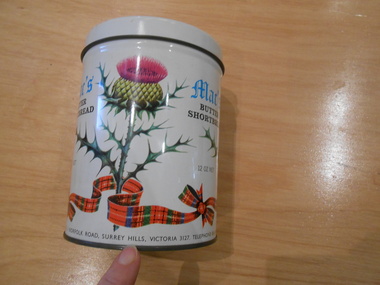
Container - Biscuit tin, Mac's Butter Shortbread tin
Mac's Shortbread Co dates its history back to a family bakery in Abbotsford opened in the 1860's producing bread for the goldfields. This eventually became McAlpine's Flour. This business was sold in 1960 and the family then purchased a cake shop, leading to building a biscuit factory. (This is thought to have been the Surrey Hills site). The company outgrew this and moved to 5 Tate Drive, Kerang. (Further research required.) Australia adopted metric units of measurement in July 1974, so this object predates 1974.This tin is material evidence of the small area of industrial activities that once existed in Surrey Hills.A cylindrical tin with a silvered interior and the outside finished in a white enamel paint, on which are 3 thistles and a tartan ribbon. 1. Mac's / BUTTER SHORTBREAD / 12 OZ NET 2. MAC'S SHORTBREAD CO., 1 NORFOLK ROAD, SURREY HILLS, VICTORIA 3127. TELEPHONE 836 0333bakeries, surrey hills, mac's shortbread, norfolk road -
 Falls Creek Historical Society
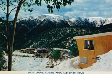
Postcard - Diana Lodge, Falls Creek
These photographs were taken in and around Falls Creek by Samuel Keith Pearce and printed for him as a foldout postcard by NuColor Vue. The postcards state they were printed for S. K. Pearce Pty. Ltd of Tawonga and Mount Beauty. Diana Lodge was built and operated by Kevin Shoebridge as a family lodge in the 1950s and it has grown and evolved over 60 years to become Diana Alpine Lodge. After Mr. Shoebridge moved to Wodonga he leased Diana Lodge to Bob Scott and it also became the Post Office and Telephone Exchange. From early early 1967 until about 1975, Diana Lodge was owned and operated by John and Gwyn van Burck. It was then purchased by a group of 12 families operating as Swan Hill Alpine Holdings. Diana Alpine Lodge has operated under several owners and was sold again as recently as 2023.This collection of postcards and images is significant because they were commissioned by a highly successful businessman in Falls Creek, Victoria and showcase the Falls Creek Tourist Area.The coloured postcard of Diana Lodge at Falls Creek.falls creek village, postcards falls creek, s. k. pearce -
 Falls Creek Historical Society
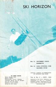
Journal - Ski-Horizon Vol 6 No 3
Ski-Horizon is the official journal of the Federation of Victorian Ski Clubs which began publication in 1949. The were 26 original member clubs which included Albury Ski Club, Bogong Ski Club, Myrtleford Ski Club, Tallangatta and District Ski Club and Wangaratta Ski Club. Two pioneers of Falls Creek, Tom Mitchell, M.L.A., and Martin Romuld were Vice-Presidents of the Federation.This Journal is significant because it documents the early development of skiing in Victoria.The journal features stories and events chronicling developments in Victoria and internationally. Items related to the Falls Creek Area in this issue include:- Cover - Rudi Wurth, winner of the National Slalom and Downhill titles at Kosciusko, 1954. Page 2 - Dawn Ski Club is a great place for families as it was designed specifically to cater for children. Toni St. Elmo is writing a book about skiing to be illustrated by Mollie Hill. The introduction will be by a well known Australian skier. Page 3 - A new standard downhill course is to be cleared on the Frying Pan Spur by Myrtleford Ski Club. In honor of the work he has done for the Falls Creek Village and for skiing in that area, it is to be named the "Tom Mitchell Course." Falls Creek Alpine Village is to be enlarged. Three new club lodges have been started, including Snowden and Nissen. Holbrook Ski Club will also be building at Falls Creek this summer.tom mitchell m.l.a., toni st. elmo, downhill courses, falls creek alpine village -
 Royal District Nursing Service (now known as Bolton Clarke)
Photograph - Digital image, c.1922
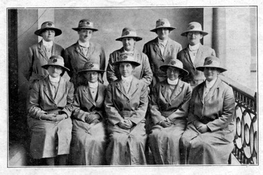
The photograph appeared in the MDNS Annual Report of 1922 and is taken on the veranda of the Melbourne District Nursing Society (MDNS) Nurses Home at 39 Victoria Parade, Collingwood. The Sisters lived and worked out of the Nurses Home from June 1914 to 1953. They attended the disadvantaged in the inner suburbs of Melbourne. The Sisters and Matron are wearing the grey uniform and hat with a red Maltese cross is in the centre of the hatband which was introduced in 1921. These Sisters, plus two others visited 29.079 visits in the metropolitan area and in suburbs as far distant as Elwood, Glen Huntly, Deepdene, Essendon and Fairfield. Of the 1666 patients on the books 394 were midwifery patients nursed in their own homes. It is believed the Matron in the photograph is Matron Reynolds. In February 1885 it was recognized that nursing care was needed for the sick poor in inner Melbourne. The Melbourne District Nursing Society (MDNS) was founded on the 17th of February with one Trained nurse (Nurse) who qualified under the Hospital training system, commencing on the 1st of May, and a second employed six months later, both working in the now CBD, ie from Spencer Street to Spring Street and from Victoria Parade to Flinders Street. From its inception the Society was at the forefront of health care. They provided high quality nursing care; educated their patients in the curing and prevention of disease; teaching the importance of cleanliness and good nutrition, both by verbal instruction and demonstration, even supplying soup and milk when needed. At that time they walked the streets and lane ways amid the slums of inner Melbourne carrying their nursing bag containing lotion, ointments, powders, liniment, bandages, dressings, a case of spirits, and the Nurse's own clean apron. The also supplied equipment, such as earthenware hot water bottles, splints, urinals, bed pans, bed cradles, feeding mugs, and air-cushions as well as providing clean bed linen and nightdresses and clothes as necessary. In 1891 the first Nurses Home was rented for 1 year at £65 per annum at 66 Cardigan Street, Carlton; Nurses wages were now £60 per annum. A Doctor gave lectures from the Home to the public on the understanding and prevention of diseases. The Society decided to commence a Midwifery Service and Nurse Fowler, who had previously worked for the Society, was re-employed as their first trained Midwife. She began home births in August 1893 giving them Ante Natal care, taking midwifery bundles and providing clothes for the babe as needed. Following birth, she gave Post-natal care to the mother and babe twice a day for three days and then daily for a week, and longer if required. She resigned after twelve months and Nurse Wilkie was appointed to the position. As well as walking, the Nurses used Public transport in the limited areas it ran, though a taxi was used by the Nurses and Midwife in emergencies and at night. Late in 1891 the Society moved to larger rented premises at 49 Drummond Street and in 1902 moved to 188 Leicester Street, Carlton. The Nurses were becoming exhausted, particularly in the heat of summer. Permission to use bicycles was given to them in 1898 and the Society decided to purchase their own in 1903. A business man offered ‘new free wheel’ bicycles at £13 each, which included maintenance for one year. Bells and wooden frames were added at a cost of £5 per frame so the Nurses could carry extra equipment. Nurses bags were strapped to the handlebars. Soup was made for those in need 2-3 times a week, and if patients could not arrange to have it collected, the soup was delivered by the Nurses on their bicycles. Their use caused a change in uniform, with white pith helmets, and veils covering them and tied under their chins, now being used. In 1904 the Society relocated to rented premises at 5 Royal Terrace, Nicholson Street in Fitzroy. In 1913 a Nurse had her ‘board and residence, uniforms, bicycles and laundry expenses’ provided and was paid £50 a year for her first six months. At the end of a year her salary was increased by £5, and later she earned £60 a year. Over the years the Nurses complained their veils became wet in the rain and asked for a change of uniform, but this did not occur until 1921. In 1914 the Society was at last able to purchase their own premises, 'Floraston' 39 Victoria Parade in Collingwood. During the Spanish Influenza epidemic, in 1919, MDNS appealed for assistance to procure Motor vehicles so the Nurses could visit an influx of cases. Through trusts, grants and donations four 'Ford 'T Model' cars were procured which enabled the Nurses to triple their visits. It was recorded on the 21st of May, that the seven Nurses had visited 1,212 persons with influenza in the last three months, how many visits to each is not known. In the whole of 1918 the Nurses, including midwifery cases, visited 1,100 persons. It was also recorded on May 7th the Nurses were delivering 100 quarts of soup to the needy each morning. In winter they also carried wood in the cars to distribute to their destitute patients as needed. In 1921-22 many of the people nursed by the Trained nurses (Sisters) suffered from malignant and tubercular disease, often the Sister would visit to find the patient was desperately ill living in a room alone and no one there to even give them a drink. In these cases the Sister would send them to hospital, but if possible most cases were nursed in their home. During July 1921- 30 June 1922 the four Midwifery trained Sisters averaged 8 confinement cases a week and sometimes gave Post Natal care to 15 to 18 patients a day. At the time of confinement a Student from the Women's Hospital accompanied the MDNS Sister and if complications occurred the patient was transferred to the Women's Hospital. The Society often had to provide blankets, sheets, set of baby clothes and night gowns for the mother. In many instances the Society provided milk for many months. The midwifery Sisters often travelled long distances in the cars Through constant use the cars were in such a poor state they were sold in 1927 and the Sisters went back to using public transport, as well as their bicycles which continued to be used in inner areas until 1945.. The Midwives used taxis when a birth was imminent. Black and white photograph showing 9 Sisters, 5 standing at rear and Matron, in the centre, of 4 seated Sisters on a balcony wearing their Melbourne District Nursing Society (MDNS) uniforms of grey coats, with revered collars and belt, over their partly seen grey uniforms with white collars. Five of the Sisters are wearing glasses. All are wearing grey brimmed hats with a Maltese cross in the centre of the lighter colour hatband. Part of deep metal scroll work of the veranda rail can be seen. A concrete wall is behind the Sisters.mdns, mdns matron, miss reynolds, royal district nursing service, rdns, melbourne district nursing society, mdns uniforms -
 Royal District Nursing Service (now known as Bolton Clarke)
Photograph - Photograph, black and white:, 1934
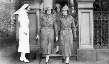
The District nurses are leaving from their Melbourne District Nursing Society (MDNS) Nurses Home, which was situated at 39 Victoria Parade, Collingwood. Their MDNS uniform dresses and coats depicted are grey, and a red Maltese cross is attached to the centre of the headband on their grey brimmed hats. The Sisters will visit MDNS patients and provide nursing care to them in their homes.From its founding in 1885 until 1891 the Trained nurses (Nurses) of the Melbourne District Nursing Society (MDNS) worked from their own homes which were located in the vicinity of their areas (districts). In November 1891 MDNS was able to rent a two story terraced house at 66 Cardigan Street, Carlton, at £65 a year, which contained accommodation for three Nurses and one pupil nurse as well as being used as their Headquarters. They left from their Nurses Home each morning and returned at the end of their shift to write up their book work before retiring for the day. Three years later they moved into a larger terraced house at 49 Drummond Street Carlton which was rented at ‘a very moderate rental’. There was a Board room, apartments for the Nurses and pupil nurse, a large dispensary which patients could attend each evening to have prescriptions signed and bottles refilled with ‘homely remedies’ and elixirs, which were administered for e.g. to Consumptive cases. Doctor’s prescriptions were filled at the Pharmacy. Cupboards containing donated blankets and bedclothes for needy patients were kept in this room, and it was here where the Nurses kept their equipment and nursing bags which were refilled at the end of each shift ready for any emergency, and for the next day. A list of Doctors the Nurses could call was kept by the telephone. The home also had a kitchen where nourishing soup was made and distributed twice a week to the needy. Milk was also distributed when needed. In 1902 they moved into rented premises at 188 Leicester Street, Carlton and two years later, in 1904, to premises at 5 Royal Terrace, Nicholson Street, Fitzroy. They remained there for ten years and an Auction of furniture was held before their next move giving an idea of some of the contents: - Carpets, linoleum, walnut and oak sideboards, dining tables, walnut dining suite, Vienna chairs, walnut bedroom suite, cedar wardrobes, chests of drawers, duchess chests, bedsteads and bedding and general furnishings were for sale. In June 1914 at last the Society had sufficient funding to purchase their own terraced premises, ‘Floraston’ 39 Victoria Parade, Collingwood which was their Headquarters and Nurses Home. In 1926 the After-Care Home for recovering patients, (later called After-Care Hospital) was built by the Society next door, at 45 Victoria Parade; the District nurses continued to live at No. 39. In November 1953 the District Nursing Division moved into their new Headquarters and Nurses Home at 452 St. Kilda Road, Melbourne. In 1957 the two divisions legally separated and the District division became the Melbourne District Nursing Service. As District expanded, and now with outlying districts to service, and with a fleet of District cars, their trained nurses (Sisters) lived in their own homes and visited their closest District Centre each morning to collect their work for the day, and returned at the end of their shift to do their administrative work. A small black and white photograph showing a side on view of Matron Lydia Shaw who is smiling. She is standing outside the Nurses Home of the Melbourne District Nursing Society (MDNS), and is wearing a white long sleeved belted uniform dress, white stockings, shoes, and a veil over her short dark hair.. She is standing to the left, outside the front gate of the building watching a group of district nurses about to leave the Home. The group are on a path behind the four trained nurses (Sisters) most visible who are dressed in grey belted long sleeved coats which have lapels. They are wearing grey brimmed hats with a Maltese cross in the centre, flesh coloured stockings and black shoes. The first two Sisters are side by side and have just stepped onto the pavement; the one to the right is smiling and slightly turned toward Matron Shaw. Under their coats, both these Sisters are wearing grey scarves around their necks. There is a square concrete column behind Matron Shaw, and another to the right of the nurses. From the right column three metal vertical fence bars are seen with shrubs behind them. Part of a building and doorway can be seen behind the nurses. A brick wall and path is seen on the far left of the photograph.The date 1934 as well as the name of Matron Shaw, Sister Jones and Sister Tupper were hand written on the back of the photographnurses, matron, uniform, melbourne district nursing society, mdns, nurses home, rdns, royal district nursing service, matron lydia shaw, sister dorothy tupper, sister jones -
 The 5th/6th Battalion Royal Victoria Regiment Historical Collection
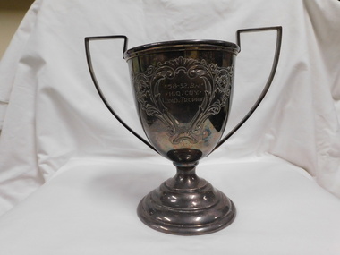
Award - Trophy, EPNS S&S, 58-32 Battalion HQ COY Command Trophy
Essendon shooting cupHistoricalSilver trophy shaped as a standard trophy with two handles and the main area has been engraved with a flower like pattern58 - 32. BN. H.Q. COY COMD. Trophy 1953 LT F.W. Hill Sig Pl 1954 SGT D.W Gray Tpt Pl 1955 L.TRBLANGDON Tpt Pl5/6 rvr, 5/6 rvr pipes and drums, command trophy -
 Federation University Herbarium
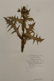
Alexander Clifford Beauglehole, Sonchus asper (L.) Hill, 25/10/1978
Cliff Beauglehole was an orchardist at Portland, Victoria, who throughout hislife took an intense interest in the plants of Victoria. Over his lifetime he collected 90,000 plant specimens as part of a comprehensive study of Victoria's plants and wrote thirteen books under the heading The Distribution and Conservation of Vascular Plants in Victoria, each written to cover the 13 study areas of the Victorian and Conservation Council.A mounted botanical specimen.beauglehole herbarium, herbarium specimen, botany, herbarium, plant science, plant specimen, field naturalists' club ballarat, federation university herbarium, sonchus asper, rough sow thistle, asteraceae -
 Melbourne Legacy
Photograph, Balnarring Camp Property, 1928
The photo shows a group of people on an outing to Stan Savige's property in Balnarring. Legatee Savige is in the striped jacket on the left. Legatee Savige had a beach side property that he allowed to be used for summer camps and outings by Legacy. In this photo there is mention of the children being from Minton Boys Home which was established in Olivers Hill, Frankston in 1924. In the early years, Legacy organised outings to the property of Legacy founder, Legatee Stan Savige, who had a place in Balnarring close to the beach. Permanent camp buildings were built in 1930. In 1930 Lord Somers (Governor of Victoria) also started a camp at a nearby property and the area was renamed Somers. Legacy Somers Camps continued intermittently at Stan's property until it was decided in 1951 to make other arrangements for holidays.The photo shows Legatees took disadvantaged children on outings to L/- Savige's property as early as 1928.Black and white photo of a group of people at Stan Savige's place.Handwritten on reverse: 'Taken on Stan Savige's place Balnarring about 1928. Includes MB Beattie with Adrian? Tony and Diana on right S?, Minton Boys Home. Photo by Aaron Beattie' in blue ink. Stamped 'Kodak print' and 'Velox'.savige property, stan savige -
 Lakes Entrance Historical Society
Photograph - Lakes Entrance Grid location, 1999
Lakes Entrance Grid reference, Cunninghame 8522.3.4 896.082, on ten acre site with trig point, it is from this point that all the survey for the surrounding areas was undertaken. Part of the Vic Geodetic Survey initiated in 1860 by Ellery Survey started from triangulation base in Werribee. (Grid ref B'dale 8422)Colour photograph of the Victoria Geodetic Survey Triangulation Station, Trig Station, situated off Ocean View Parade, Merrangbaur Hill. Location is indicated by ground point and standing structure, situated on an elevated bush block. Lakes Entrance Victoriasurveying, township planning -
 Eltham District Historical Society Inc
Photograph, C.S. Wingrove, Secretary, Eltham District Road Board 1858-1871; Shire Secretary, Shire of Eltham 1871-1904, 1858-1871
Charles Symons Wingrove, J.P. (1829-1905) arrived in Victorian in 1851. He had trained as an engineer, but tried his luck on the goldfields. In 1857 he was appointed as Secretary to the Eltham District Roads Board only one year after its foundation. He was to hold the position with the Board and later the Eltham Shire Council for total of 47 years. He also held the position of engineer for a large part of this period. During part of this time he was also secretary to the Heidelberg Shire Council. Over this period he was responsibly for an area stretching from Clifton Hill to Healesville, along the northern bank of the Yarra River. Other positions included Secretary to the Victorian Agricultural Society over along period.Wingrove was a main figure in the Municipal Association of Victoria. By the time he retired he was recognized as the “Grand Old Man” of Victorian local government. In 1858 Wingrove had a brick cottage built in Main Road near the State School and he lived here until his death. One room was uded as the Board and Council office. His descendants owned the house until 1974. It was later used as a psychiatric clinic. The park opposite the cottage has been named Wingrove Park in his honour. He is buried at St Helena with other members of his family. Age (Melbourne, Vic. : 1854 - 1954), Tuesday 18 July 1905, page 5 ABOUT PEOPLE. A conspicuous figure in northern municpal history, Mr. Charles Symons Wingrove, has passed away. He was for many years secretary and engineer for the shire of Eltham, and prior to the formation of the shire held the position under the old road board, his official connection with the district dating from beyond 1857. For about twelve years he also filled the position of shire engineer for Heidelberg council while retaining his other post, and the immense territory under his professional control, reaching from the boundary of Collingwood up to Healesville, was a matter of fatherly pride and interest to him. He arrived in Victoria in 1851, and was 76 years of age at his death. Mr. Wingrove retired from the position in the Eltham council only about a year ago. The interment will take place in St. Helena Cemetery, near Eltham township, today. Secretary, Eltham District Road Board 1858-1871 Secretary for the Shire of Eltham 1871-1904. Nearly 50 years service to the local community. For about twelve years he also filled the position of shire engineer for Heidelberg council. Reproduced Page 137 "Pioneers & Painters" This photo forms part of a collection of photographs gathered by the Shire of Eltham for their centenary project book,"Pioneers and Painters: 100 years of the Shire of Eltham" by Alan Marshall (1971). The collection of over 500 images is held in partnership between Eltham District Historical Society and Yarra Plenty Regional Library (Eltham Library) and is now formally known as the 'The Shire of Eltham Pioneers Photograph Collection.' It is significant in being the first community sourced collection representing the places and people of the Shire's first one hundred years.Digital image Print 25 x 20 cmc.s.wingrove, charles symons wingrove, eltham district road board, sepp, shire of eltham pioneers photograph collection, shire secretary, wingrove cottage, pioneers and painters, shire of eltham, councilor, municipal officer -
 Warrnambool and District Historical Society Inc.
Booklet - Warrnambool Visitor's Handbooks 1979-2024, Collett, Bain and Gaspar, Printers, 1979-2014
This is a collection of eight Warrnambool Visitor handbooks produced between 1979 and 2014 by the City of Warrnambool Tourist Information Centre. They contain maps of Warrnambool, lists of services, accommodation and tourist attractions as well as many advertisements for local businesses.These handbooks give a useful snapshot of businesses and tourist attractions in Warrnambool for each of the years covered. (1979, 1980, 1986, 1990, 1993, 1994, 1995, 2014)[.1a] A 48 page booklet with white pages and blue printing. The front cover has a coloured photograph of Flagstaff Hill with boats on a man made lake in the foreground looking across Lake Pertobe toward South Warrnambool. [.1b] A coloured bifold brochure. The front cover has a fisherman on a cray-boat holding a crayfish in the lower section. The top quarter has a blue back ground with white printing. The rear cover is red and has small photos of the Hopkins River and the Framlingham Forest. [.2] A 48 page booklet with white pages and black printing. The front cover is white with black writing on the left hand side and a colour photograph of the Loch Ard peacock. The Warrnambool Premier Town stylised logo of seven Norfollk pines above blue waves is in the top right hand corner. There is a blank ink Warrnambool Library stamp underneath the logo. The rear cover has photographs of The Twelve Apostles and the Hopkins Falls and the Premier Town Logo [.3] A 40 page booklet with mainly black printing on white paper. There are three fold out maps of Warrnambool and the surrounding district. The glossy cover has a black background with a colour photograph of the Twelve Apostles taken at sunset. The rear cover has three small of Proudfoot's boathouse on the Hopkins River, Flagstaff Hill, and the main beach area. The front cover has black writing inside to peach coloured rectangles. The inside rear cover has a fold out coloured tour map of Western Victoria. [.4] A 40 page booklet printed on glossy white paper with coloured photographs and black and red printing. The front cover has a photograph of The Twelve Apostles surrounded by a white border. There is red writing in the upper border. There is a sandy coloured writing superimposed across the bottom of the photograph and a Victoria's Shipwreck Coast logo in the bottom right hand corner. [.5] A 44 page booklet printed on white paper with black printing. The cream coloured cover has a pale red rectangle with blue writing on the right hand facing edge and includes two stylised Norfolk pines and with waves underneath. There is is an intersecting blue rectangle with cream printing. [.6] A 48 page booklet printed on white paper with black printing. The cover is brown with a cream vertical strip containing black writing on the right hand side. There is a stylised map from Geelong to Mount Gambier showing the Great Ocean Road across the cover. [.7] A 48 page booklet printed on white paper with black print. The glossy colour cover has a photograph of a Southern Right whale fluke. There is white printing on a the blue background of the sky and sea. The bottom left hand side of the front cover has a Tourism Victoria logo made of jigsaw puzzle pieces. The back cover has a stylised coloured map of The Great Ocean Road located in a white rectangle at the top of the page. Within the rectangle is a small map of Australia locating Victoria and the part of Victoria covered by the map. [.8] A 64 page A5 coloured booklet printed on white pages with black print. The white front cover has black and grey print with a colour photograph of two people holding coffee cups watching four race horses being exercised on the beach and in the water of Lady Bay in the early morning. The bottom right hand corner has a Tourism Victoria logo. The rear cover has a mainly blue back ground with a pink orange and green colour splats contains words advertising the 2015 Fun 4 Kids Festival [.1a] Warrnambool The Heart of Victoria's Great Southwest Visitor's Handbook [.1b] Warrnambool City for all seasons; The Heart of Victoria's Great Southwest [.2] Warrnambool visitor's handbook Warrnambool Premier Town 1979-1982 [.3] Warrnambool Handbook Victoria [.4] Warrnambool The Shipwreck Coast [.5] Welcome to Warrnambool Warrnambool Visitors Handbook 1993-1994 [.6] Welcome to Warrnambool Visitors Handbook 1994-95 Rear cover: Warrnambool Centre of Victoria's Shipwreck Coast on Australia's Great Ocean Road [.7] Warrnambool Shipwreck Coast - Great Ocean Road; You'll love every piece of Victoria; Visitors Handbook [.8] Warrnambool Great Ocean Road Official Visitor Guide; It's a wonderful Warrnambool; You'll love every piece of Victoria visitvictoria.com. Rear Cover Live entertainment.Workshops.Creativity.Action 28 June - 5 July 2015 Australia's Best Children's Festival F4K The ultimate winter school holiday adventure Fun 4 kids festival Warrnambool For more information visit Fun4kids.com.au Warrnambool great Ocean Road Victoriawarrnambool, visitor handbooks, tourist information guides, warrnambool maps -
 Flagstaff Hill Maritime Museum and Village
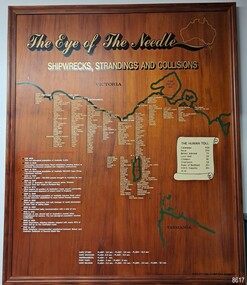
Artwork, other - Shipwreck Board, The Eye of the Needle: Shipwrecks, Stranding's and Collisions, ca 2002
The Shipwreck Board is a feature of Flagstaff Hill Maritime Museum and Village/ its subject is explained briefly in the Museum's handbook, The Flagstaff Hill Navigator, published in 2008: - "Known as the ‘Eye of the Needle’ the treacherous entrance to Bass Strait is littered with the wreckage of large international vessels and smaller sail and steam craft used in coastal trade. The vessels bringing emigrants and cargo to Australia found the western entrance to Bass Strait the most dangerous part of their voyage. They had to thread their way between the southern point of Victoria (Cape Otway) and the northern point of King Island, a stretch of water less than 90 km wide. Many smaller coastal vessels were lost at Portland, Port Fairy, Warrnambool and Apollo Bay which are not safe harbours in certain weather conditions. "The Shipwreck Board shows shipwrecks, strandings and collisions which occurred in this area up to the year 1940. Wrecks are identified by a yellow light and collisions/strandings by a green light. These lights also identify the decade the wreck occurred by lighting up when the relevant decade button is pushed. Interesting happenings of the decades are listed next to the buttons." The Shipwreck Board's demonstration of The Eye of the Needle is an interactive visual display that helps teach the perils and dangers faced by early settlers in Victoria. It tells of the vast number of lives lost. It lists the names of many infamous shipwrecks and significant events.The large stained and lacquered timber board is mounted in a timber, frame. It is painted with a small sketch of Australia, and an enlarged outline of the southern coast of Victoria, King Island and the North West coast of Tasmania. The interactive display highlights the shipwrecks, standings and collisions suffered by many vessels as they navigated the 'Eye of the Needle', a narrow stretch of Bass Strait. The locations of the Lighthouses are pinpointed. Lists of groups of ships are below the coastlines. A painted scroll shows eight major shipwrecks with the number of lives lost for each one. A table shows historical facts associated with the decades from pre-1830 to 1940. A system of coloured lights compares the decades with the vessels that suffered damage. The board was created by artist and signwriter, Alex O'Flynn Computer Signs.flagstaff hill, maritime museum, maritime village, shipwreck coast, eye of the needle, shipwreck locations, bass strait, basses strait, king island, north west tasmania, south coast of victoria, cape otway, victorian lighthouse, king island lighthouse, strandings, coastal tracers, emigrant ships, sea trade, 1930s-1940s, shipwreck board, the eye of the needle, collosions, alex o'flynn, alex o’flynn computer signs, shipwrecks of western victoria -
 Melbourne Tram Museum
Slide - Set of 4, Ron Scholten, Jun. 1973
Set of four colour slides, white cardboard, by Kodak, of trams 912 and 1018 in the City area testing clearances around safety zones, as part of the development of the Z class tram. Done on a Sunday morning. .1 - 912 in Flinders St with Flinders St station, platform 1 west in the background - slide dated May 1973. .2 - tram 1018, without the tram protrusion on the top of the car body as in 912 at Victoria Parade and Brunswick St. Tram 644, City Brunswick St, in the background. In the back is Eastern Hill Fire Station. .3 - as above. Has advertising for Amoco Petrol and White Horse Whiskey .4 - 1018 in Brunswick St returning to Preston Workshops. Has St Patrick's Cathedral. Slides 2 and 3 are dated June 1973.All have a running number "1202" and "1218", "1219" and "1221" and "1018" written on the slide.trams, tramways, w7 class, sw6 class, flinders st, testing, safety zone, bourke st, safety, z class, brunswick st, victoria parade, tram 1018 -
 Eltham District Historical Society Inc
Photograph - Digital Photograph, Marguerite Marshall, Eltham Lower Park, 20 April 2008
Originally a race course, the park has brought the community together with a variety of activities. Published: Nillumbik Now and Then / Marguerite Marshall 2008; photographs Alan King with Marguerite Marshall.; p45 Once used for horse racing, which attracted visitors from Melbourne, the Eltham Lower Park has brought the community together with a wide range of activities. Horse riding is now enjoyed as a recreation in the park as are other sports. The park also includes the Diamond Valley Railway miniature trains and a sanctuary for the rare and vulnerable Eltham Copper Butterfly. Eltham Lower Park, with other parks, forms an almost continuous green band from Eltham’s centre, along the Diamond Creek to the Yarra River.1 Before European settlement the Wurundjeri people met on this land, particularly at the junction of the Diamond Creek with the Yarra River, which they called Birr-arung. This is commemorated by the sculpture, Not just a Pretty Place by Aleks Danko, winner of the 2000 Nillumbik Art in Public Places Award. The first European to settle here was probably Henry Foley, who in 1841 used it as part of his pastoral run. Foley sold his leasehold to Joseph Wilson in 1845, who soon after sold it to Frederick Falkiner. During the 1840s the future park was part of a government square mile (2.6 sqkm) reserve, north of the Yarra, within the Parish of Nillumbik, later named Eltham. Soon the land was used for horse racing after nearby residents cleared ten acres (4ha) in the early 1850s. A three-quarter of a mile (1.2km) race secured the winner the £10 Publican’s Prize. In response to popular demand, the newly formed Eltham District Road Board petitioned the Surveyor General of the Colony of Victoria, in 1856, for 36 acres (14.6ha) of crown land for a racecourse and recreation. By 1858 the Eltham races had become an institution. ‘Many skirmishes occurred and the way home was paved with temptation, with sly-grog for sale.3 In the early 1870s, two jockeys were sons of the police officer in charge of the Eltham Police Station, Miles S Lyons. Another ten acres (4ha) was added to the area in 1866 and 12 acres (4.8ha) – Hohnes Hill – in 1870. In 1866, two acres (0.8ha) on the creek banks became an animal pound with William Walsh the pound keeper in 1870, but this was later incorporated into the park. By 1877 the area was called a public park but horse racing and training continued into the 1920s. In the mid-1900s trotters were trained on a circuit road. In 1953 the Eltham Pony Club was established and used a cross-country course on Hohnes Hill. From the mid 1950s the club held the Eltham Easter Fair at the park, later to include a procession along Main Road from the town centre to the park. The park also attracted picnic parties and campers from the inner suburbs as did Wingrove Park, and businesses catering for visitors, sprang up on the opposite side of Main Road. Bus-loads of school children visited the park for Gould League bird days in the 1960s. In 1979 the Eltham Shire Council bought Lenister Farm, linking the park with the Yarra River. The Lenister Farm wetland includes a bird hide, viewing platform and interpretive signs.5 Pioneer Henry Stooke, later Road Board chairman, bought the 11 acres (4.5ha) - later to become Lenister Farm - from the Crown in 1862. Stooke never lived on this site and the two houses at Lenister Farm were built in the 20th century. Since its formation in 1871, the Council has controlled this crown land, which it named Eltham Park. But in the 1920s Eltham Council bought land near the town centre for a park, which it named Eltham Central Park. To avoid confusion the Council renamed Eltham Park, Eltham Lower Park. Since 2004 the Yarra footbridge has linked the park with the Yarra Valley Metropolitan Park and the Main Yarra Trail.This collection of almost 130 photos about places and people within the Shire of Nillumbik, an urban and rural municipality in Melbourne's north, contributes to an understanding of the history of the Shire. Published in 2008 immediately prior to the Black Saturday bushfires of February 7, 2009, it documents sites that were impacted, and in some cases destroyed by the fires. It includes photographs taken especially for the publication, creating a unique time capsule representing the Shire in the early 21st century. It remains the most recent comprehenesive publication devoted to the Shire's history connecting local residents to the past. nillumbik now and then (marshall-king) collection, eltham lower park, eltham park