Showing 10936 items matching " land"
-
 Bendigo Historical Society Inc.
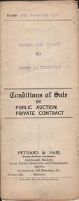
Document - H.A. & S.R. WILKINSON COLLECTION: CONDITION OF SALE
Conditions of sale by private contract, dated 9th November 1922 issued by Pethard & Ham between George Ford Sansom (seller) and Henry A. Wilkinson ( buyer) for land situate Bakewell Street Bendigo. Crown allotment 331 section E Parish of Sandhurst city and county of Bendigo described in certificate of title volume 1784 folio 356656, together with 5-roomed brick and rough cast house and all sundry. Price 375 poundsorganization, business, h.a. & s.r wilkinson real estate -
 Bendigo Historical Society Inc.
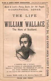
Book - LYDIA CHANCELLOR COLLECTION: THE LIFE OF WILLIAM WALLACE
A book titled 'The Life of William Wallace the Hero of Scotland. A warrior and a patriot, who in a period of lawlessness and wrong manfully maintained the principles of justice, and stood forward in defence of the rights and liberties of his native land.' London : Ward, Lock & Co., Salisbury Square, E.C. 497 - 512 pgs. This booklet is one of a series of 53 ' Ward & Lock's Penny Books for the People.' 'Biographical Series.' Price one penny. There are also advertisements of note.books, biography, william wallace, lydia chancellor, collection, the life of william wallace, william wallace, male, individual, person, famous people, ward & lock's penny biographies, ward & lock's penny books for the people, penny books, biographical series, biographies, scotland, scottish history, advertisements -
 Bendigo Historical Society Inc.
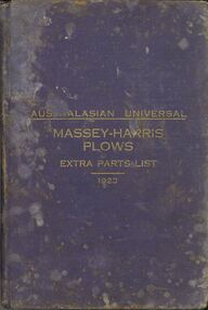
Book - ERROL BOVAIRD COLLECTION: AUSTRALASIAN UNIVERSAL MASSEY HARRIS PLOWS EXTRA PARTS LIST 1923
Book with dark blue cloth cover, gold printing on the front and pinkish red edges to the pages. Australasian Edition, Universal List of Extra Parts for Repairs for Ploughs, Scufflers, Land Packers, Rollers, Barrows, &c. Published in 1923. Massey-Harris Co., Limited Toronto, Canada, and Melbourne, Australia. Book has illustrations of the different plough, etc. and description of part. There are plates with drawings of parts and numbers and illustrations of bolts, cotters and nuts, etc.rural industry, agriculture - cultivation, massey-harris plows, john bovaird collection - australasian universal massey-harris plows extra parts list 1923, massey-harris co limited -
 Bendigo Historical Society Inc.
Document - NORMAN OLIVER COLLECTION: SPEECH NOTES 11 JULY 1951
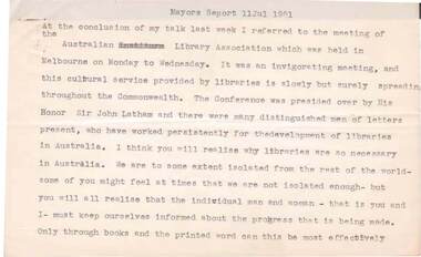
The Norman Oliver collection. Norman Oliver was three times Mayor of Bendigo - 1950-51, 1964-65, 1970-71. Fifteen typed pages headed Mayors Report 11 July 1951. In the format he used for his weekly talk on 3BO 'The Mayor Speaks'. Topics include : Australian Library Association, the Rosalind Park Land Bill, assistant engineer's house, the Transport Regulation Act, the Lighting Committee, the Engineer's Report,bendigo, council, speech notes, norman joseph oliver , councillor norman oliver. mayor of bendigo. 3bo 'the mayor speaks'. -
 Whitehorse Historical Society Inc.
Document, Stacker orchard, 1886-1984
Land titles associated with the Stacker orchard.Land titles associated with the Stacker orchard. Originally part of 120 acres bounded by Whitehorse, Springfield, Barnes (now Surrey) roads held by Freehold Investment and Banking Company Ltd. With chronology 1886-1984. Certificates of Title: Vol. 1877 Fol. 375367, 1886; Vol. 2856 Fol. 571133, 1902; Vol. 6062 Fol. 1212305, 1935; Vol. 6818 Fol. 1363560, 1945; Vol. 9531 Fol. 645, 1983-84.Land titles associated with the Stacker orchard. stecher, august, stecher, frederick leslie, stacker, grace e m, stacker, reginald f, stacker, marion k, artman nominees pty ltd, orchards, freehold investment and banking company of australia ltd -
 Surrey Hills Historical Society Collection
Photograph, Bill Willaton on one of Tacey's butcher's shop delivery horses, c 1920, 1920
The date is approximate. Bill Willaton was a driver for C E Gray & Son, bakers of Canterbury during the 1930s. Tacey's butcher shop (dem) was located at 629 Canterbury Road. Black and white photo of a young boy on a light-coloured horse in vacant land adjacent to Canterbury Road, Surrey Hills. In the background a girl is standing in front of a new-looking paling fence behind which can be seen local landmarks. On the right is Hansen's Terrace; on the far left part of the Surrey Hall can be seen and in the middle ground the rear of McNeill's Family Hotel (Surrey Lodge), Dartnell's corner and the side of the post office.tacey's butchers, horse-driven vehicles, hansen's terrace, surrey hills post office, surrey lodge, mcneill's family hotel, surrey hall, william willaton, bill willaton, surrey hills, canterbury road -
 Bacchus Marsh & District Historical Society
Map, Allotments in the Village of Rowsley, Parish of Gorrocburkghap, County of Grant c.1856
Rowsley is a locality 11 kilometers south-west of Bacchus Marsh. The date of this map is uncertain. A very similar map held by the State Library of Victoria (SLV) contains slightly more information than this copy and is dated as an 1856 map. SLV reference: 'Allotments in the Village of Rowsley, Parish of Gorrocburkghap, County of Grant', by T. Nixon, Assistant Surveyor, May 1856 ; Surveyor General’s Office, July 18 1856 (lithographed by R. Meikle). (1856). Melbourne: Surveyor General’s Office. MAPS 820 BJE 1837- ROWSLEY 1856. A single page paper map. A cadastral map of the Village of Rowsley in Victoria, showing numbered land allotments. 57 allotments are shown on the map and some areas set aside as reserves. Allotments 8, and 10-16 are outlined in red ink and allotment 9 has a cross in red ink on it. The map is pasted into a bound volume containing 76 maps or plans in total. High resolution digital image stored on BMDHS computer network. rowsley victoria history, rowsley victoria maps -
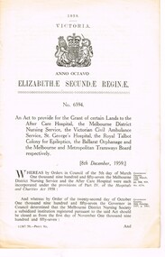 Melbourne Tram Museum
Document - Personal Papers, Victorian Parliament, "Grant of certain Lands etc.", 1959
Act of Victorian Parliament, 8 pages, No. 6594 - "An Act to provide for the Grant of certain Lands to the After Care Hospital, the Melbourne District Nursing Service, the Victorian Civil Ambulance Service, St Georges Hospital, the Royal Talbot Colony for Epileptics, the Ballarat Orphanage and the Melbourne and Metropolitan Tramways Board respectively. Page 4 and 7 detail a block of land that the Board could have purchased for a major bus depot in Footscray Road for 60,175 pounds.trams, tramways, tramways, acts of parliament, mmtb, buses, depot, footscray rd, construction -
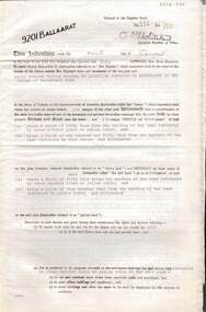 Bendigo Historical Society Inc.
Document - MCCOLL, RANKIN AND STANISTREET COLLECTION: INDENTURE GOLD MINING LEASE 9201 BALLAARAT
6 page document plus map: indenture, gold mining lease dated 9th August 1960, between the Crown and North Deborah Mining Company, carrying on operations in the Parish of Moorarbool West . Key on map indicates depth to which land may be excised. On map: Mining District of Ballarat, County of Grant, Parish of Moorarbool West. Total area: 285 acres 1 rood, 20 perches. Vol 334, Fol 202.bendigo, mining, deborah gold mines -
Glen Eira Historical Society
Plan - Warrigal Road, Oakleigh
Documents about a small portion of land on Warrigal Road Oakleigh, now Oakleigh East. A Letter dated 29/05/1952 from Gas and Fuel Corporation of Victoria to Mr. L.P. Simmonds requesting valuation of land for proposed widening of Warrigal Road. A plan of Survey, no.5474, for Crown portion of Parish of Moorabbin and Parish of Mordialloc for owner The Brighton Gas Coy Ltd. New Street Brighton. Mortgages to the National Mutual Life Association. A letter dated 04/06/1952 from Gas and Fuel Corporation of Victoria in reference to Warrigal Road and Centre Road from the Country Roads Board who desire to acquire the land. Handwritten calculation notes and price for valuation, most likely as an attachment to the letter dated 04/06/1952.gas and fuel corporation, warrigal road, centre road, moorabbin council, simmonds l.p, survey plan, county of bourke, the brighton gas company ltd., country roads board, the national mutual life association of australia ltd., bentleigh east -
 Warrnambool and District Historical Society Inc.
Document - Warrnambool City Council Preliminary Report Industrial Estate West Warrnambool, E Johnson, 9 March 1973
This preliminary report relates to 32½ acres of council owned land in West Warrnambool bounded on the North by McMeekin Road, on the East by Scott Street, on the South by Evans Street and on the West by the rear boundaries of properties facing Landmann and Granter Streets. In 2010, West Warrnambool was the largest of Warrnambool’s existing industrial areas, comprising approximately 109ha of industrial zoned land, the majority of which (101ha) is zoned IN1Z, with the remainder zoned INZ3. The area comprises a mixture of lot sizes supporting a diverse mix of industries. Larger parcels are occupied by the abattoirs, scrap metal industries, freight, the Council Depot and storage. Smaller lots are occupied by smaller manufacturers and wholesalers and service industries. [Ref: Warrnambool Industrial Land Use Review. Mesh Pty Ltd July 2010]This document is a preliminary report prepared by the Warrnambool City Council Engineer in March 1973 and provides an example of the planning process undertaken to develop one of Warrnambool's industrial areas. It contains details and costings of the proposed subdivision. Two foolscaps size pages of typewritten information. A detailed topographical map of the area with areas highlighted in blue, red, green, blue and purple pen.warrnambool city council, west warrnambool, industrial estate -
 Greensborough Historical Society
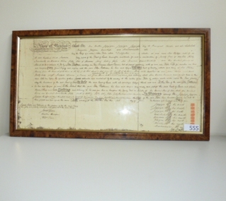
Document (Framed), Batman's Treaty of Melbourne, 06/06/1835
John Batman recorded in his journal that he had signed a treaty with the local Aboriginal people, the Wurundjeri to buy 2,000 km of land around Melbourne and another 400 km around Geelong. In exchange he gave the eight chiefs whose marks he acquired on the treaty, a quantity of blankets, knives, tomahawks, scissors, looking-glasses, flour, handkerchiefs and shirts. Under British law, the treaty was legally invalid as the land belonged to the Crown, not to the Wurundjeri. Although the treaty was declared null and void by Governor Bourke within six months of John and Henry Batman and the Port Phillip Association organising this treaty, it remains an interesting part of Melbourne's early history. Copy of Batman's Treaty of Melbourne, 1835. Original hand written on parchment in triplicate. john batman, wurundjeri, treaty of melbourne, melbourne history, batman's treaty -
 Eltham District Historical Society Inc
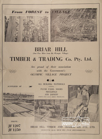
Poster, Briar Hill Timber & Trading Co. Pty. Ltd, c.1956
Advertisement insert in The Age newspaper around the opening of the 1956 Olympic Games promoting Briar Hill Timber's association with the Olympic Village Project being suppliers of all building materials including Flush Panel Doors, Mouldings and Joinery. Briar Hill Timber owned by F. Squire and the Squire family owned a lot of land around Briar Hill and land for forest at Flowerdale. Operations ranged from logging of trees, to milling to manufacture of joinery and housing frames.Poster approximately A2 in sizebriar hill timber, f. squire, olympic village, 1956 olympic games, timber mill, flowerdale, briar hill, h.v. plowman, logging, advertisement -
 Ringwood and District Historical Society
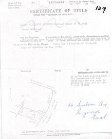
Document, Partial copy of Certificate of Title Vol 7635 Fol 096 Lot 29, 44 Sunbeam Avenue Ringwood East, Victoria
Black and white photocopied page with added notations in blue pen.Ellen Elizabeth Stanton, Married Woman of 35 Bell Street Richmond is now the Proprietor of an estate in Fee-simple, subject to the Encumbrances notified herunder in the surface down to the depth of fifty feet below the surface of the pie of land delineated and colored red purple and blue on the map in the margin, being Lot 29 Parish of Ringwood. Plan of Subdivision No. 12150. (undated). -
 City of Moorabbin Historical Society (Operating the Box Cottage Museum)
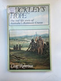
Book, Globe Press Pty. Ltd, Buckley's hope : the story of Australia's wild white man, 1981
A small soft cover book with a blue/green cover,on the front cover is a painting of early Australia with Indigenous Australians hunting with spears alongside them is a European with long unkept hair and a beard dressed in animal skins,on the back cover is text by the author giving a brief outline of the book.buckley, sorrento, robinson crusoe, port phillip, van diemen's land, colonialism, 1840, convicts, indigenous tribes. -
 Mt Dandenong & District Historical Society Inc.
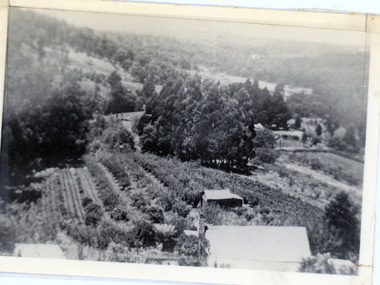
Photograph, 1913 View Over Logan's House in Village Settlement, 1913
Photograph taken in 1913 from Barbers Road showing the view down the valley. Roof in foreground is house on Bob Logan's Lot 28 in the Village Settlement. This photograph has a detailed inscription on the back handwritten by John Lundy-Clarke in 1974.1913 view over Logan’s house on Village Settlement Lot 28 taken from Barber’s Road. This is the house that the runaway log leaped over in 1930 to land far down the orchard row beyond the house. “Shiloah” is centre partly behind the clump of trees and the paddocks of Child and Richardsons pioneer selections are in the background. Link Road is centre right.logan, bob logan, robert logan, barbers road, shiloah, child, richardson, link road -
 Ringwood and District Historical Society
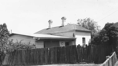
Photograph, Original Ringwood Police Station built 1888. c1973
Black and white photograph of weatherboard and brick building. Typed under photograph: "Original Ringwood Police Station (brick building). 32 Mt Dandenong Road. (Police Station 1888)." Written on rear of backing sheet: "Right hand building was first station. Site cost £20 in 1888. Mtd Const. Waters first to occupy it. Building and land sold 1974 for $20000. 32 Mt. Dandenong Road." -
 Eltham District Historical Society Inc
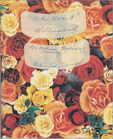
Album - Photo Album, Ruth Pendavingh, Take Heart, Nillumbik, 1998-2002
Album of photographs associated with activities of the Cardiac Rehab "Take Heart" Group including the Arthritis Group (Land and Water exercise) managed by Eltham Community Health Centre allied health assistant, arthritis group (land and water exercise), arthritis group, arthurs creek, betty willis, bundoora park, cardiac rehab 'take heart' group, christmas break-up, diamond valley railway, dirk pendavingh, elizabeth dick, eltham community health centre, eltham health group, eltham leisure centre, eltham lower park, eltham, ernie robinson, fairfield park, fairfield, flagstaff hill, griffiths park, ken willis, lavender farm, migrant teachers, mt cooper, new eltham diabetes contact group, parkinson support group, picnic, ruth pendavingh, scienceworks, sugarloaf reservoir, veronica white-hall, warringal, water exercise group, warrrnambool, warrnambool rsl -
 Eltham District Historical Society Inc
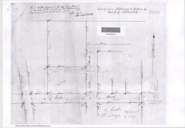
Document - Photocopy, Survey Fleld Notes of Part of Crown Portion 13, Section 4 at Eltham, Parish of Nillumbik, County of Evelyn, 31 May 1907
Portion of land east of Main Road and north of Luck Street bounded by Bible Street Application 36708 K. Arndt, Licensed Surveyor, 31 May 1907application 36708, bible street, eltham, luck street, main road, map, survey plan -
 Eltham District Historical Society Inc
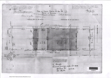
Document - Photocopy, Survey Fleld Notes of Part of Crown Portion 12, Section 4 at Eltham, Parish of Nillumbik, County of Evelyn, 12 October 1910
Portion of land bounded by: Main Road, John Street, Bible Street, Pitt Street Application 38858 K. Arndt, Licensed Surveyor, 12 August 1910application 38858, bible street, eltham, john street, main road, map, pitt street, survey plan -
 Eltham District Historical Society Inc
Document - Photocopy, Survey Fleld Notes of Part of Crown Portion 12, Section 4 at Eltham, Parish of Nillumbik, County of Evelyn, 30 September 1925
Portion of land bounded by: Main Road, Franklin Street, Bible Street, Brougham Street Application 46839 R. Woodcock, Licensed Surveyor, 30 September 1925application 46839, bible street, brougham street, eltham, franklin street, main road, map, survey plan -
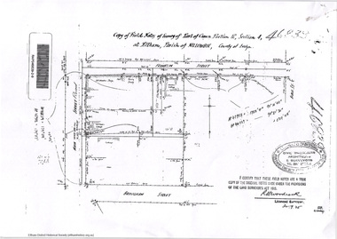
 Eltham District Historical Society Inc
Document - Photocopy, Survey Fleld Notes of Part of Crown Portion 12, Section 4 at Eltham, Parish of Nillumbik, County of Evelyn, 18 March 1926
Portion of land bounded by: Main Road, York Street, Bible Street, Bridge Street Application 46906 R.H. Woodcock, Licensed Surveyor, 18 March 1926application 46906, bible street, bridge street, eltham, main road, map, survey plan, york street -
 Eltham District Historical Society Inc
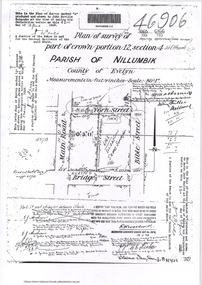
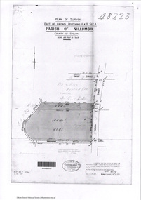
Document - Photocopy, Survey Fleld Notes of Part of Crown Portions 12 & 13, Section 4 at Eltham, Parish of Nillumbik, County of Evelyn, 6 May 1929
Portion of land bounded by: Main Road, York Street, Diamond Creek, Swan Street Application 48223 P.N. Guy, Licensed Surveyor, 6 May 1929application 48223, diamond creek (creek), eltham, main road, map, survey plan, swan street, york street -
 Eltham District Historical Society Inc
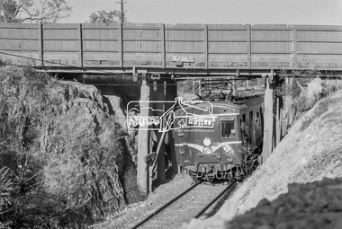
Photograph, George Coop, A Hurstbridge bound Harris (Blue) train passes underneath the Silver Street railway overpass at Eltham, March 1980, 1980
The Harris trains operated in Melbourne 1956-1988. They were full of asbestos and were taken out of service, wrapped in plastic and buried in land fill near ClaytonDigital TIFF file Scan of 35mm Kodak Safety 5063 black and white transparencyharris (blue) train, eltham, silver street, overpass -
 Greensborough Historical Society
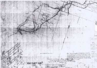
Document - Road Plan, Road acquisition, St Helena Road, 1859, 1889
Road plan showing land acquisition for the road to Diamond Creek (NOT Diamond Creek Road), also known as Eltham Road and now known as St Helena Road.Shows the land through which St Helena Road runs, with original owners marked on plan.1 page. Copy of road planroad plans, st helena road greensborough, diamond creek -
 Greensborough Historical Society
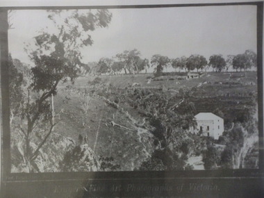
Photograph (copy), Fred Kruger, On the Plenty River near Bundoora / photograph by Fred Kruger, 1877c
View of farm land and mill on the Plenty River near Bundoora, circa 1877; photograph by Fred Kruger. Original held at SLV (accession # H473 and Image # a53840)Black and white photograph, enlarged and laminated.fred kruger, plenty river -
 Greensborough Historical Society
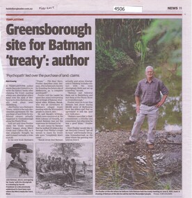
Newspaper - Newspaper Clipping, Heidelberg Leader et al, Greensborough site for Batman "treaty": author, by Rick Koenig, 2017_02
Jim Poulter's research indicates that the accepted account of Batman's Treaty with aboriginal elders regarding purchase of the land of Melbourne is not true. He claims the Treaty was signed in Greensborough.Newspaper clipping, text and images. Date written in black ink: "Feb 2017"john batman, batmans treaty -
 Greensborough Historical Society
Article, Avril Salter, Yallambie Homestead, by Avril Salter, 1970_
This history of Yallambie Homestead was written by Avril Salter in 1970. It covers the property since its original land grant, to the homestead until and after its alteration in 1923. A history of one of the areas homesteads which is still in use today.Research article, 43 pages, text only. Photographs which accompanied the original text were lost.yallambie homestead, yallambie, avril salter -
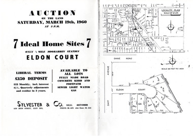 City of Moorabbin Historical Society (Operating the Box Cottage Museum)
Flyer - Eldon Court, Moorabbin
In the mid 1900's land sales in Moorabbin began of the remaining market gardens which were being sub divided. Eldon Court was auctioned off in 1960Example of the progress of the Municipality of MoorabbinPhotocopy of advertising flyer for auction of real estate sales - plan of building blocks for saleEldon Court, Moorabbin - 7 Home sites - Saturday March 19 1960eldon court, moorabbin, real estate, auction -
Tatura Irrigation & Wartime Camps Museum
Photograph - copy, copy 1989
WW2 internment camp 1, Tatura, was built on land owned by Mr J. B. Noonah and consisted of mainly German internees. A large and modern hospital was located there. Black and white photograph of hospital site sign. No. 3 Internment campon back. Remains of hospital site, internment camp no. 3.internment camps, tatura internment camps, j. b. noonan, german internees