Showing 4058 items
matching etc.
-
 Kiewa Valley Historical Society
Case - Roper's Hut Visitors' Journals
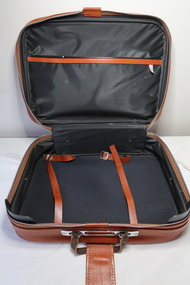
Roper's Hut belonged to the Roper family who brought their cattle up onto the Bogong High Plains during summer. Their hut was visited and used by skiers and walkers. The log books kept a record of their visits over the years.The log books gave an insight into the activities of visitors, the weather, the frequency, etc. The case was a safe place for storage of these books.Light brown vinyl case with zip fastener around three sides and partly at the back on each side. There is a separate pocket at the top with a zip fastener. There is a flap to fasten the case across the centre top and a leather handle. The zip around the case has a silver fastener with a small key hole.The inside is mostly black and has two vinyl straps that fasten to hold the contents in place and there is an open pocket inside.roper's hut case, roper's hut log book, cattlemen's hut -
 Kiewa Valley Historical Society
Manila Folder - Newspaper cuttings and photos - Ryder Family, Ada & Walter Ryder Family
The Ryder family have lived and farmed in the Kiewa Valley since the 1840sMemorabilia of the Ryder family in the Kiewa Valley is an example of changing activities and interests etc in the Kiewa Valley since the 1840s through to the current day.1. Merit Certificate for Dorothy Ryder 1938 2. Three newspaper cuttings a) Hospital Town Highlight b) Time Moves On c) Joan Lang - the woman who could...and did! 3. Three slides a) Dairy Farm on banks of Kiewa River b) Mt Beauty c) Rocky Valley Dam 4. Four photos a) Beatrice Ryder on Empire Day b) Ada with son Walter Ryder c) Beatrice & Vera Ryder d)Skiers on High Plainsb) and c) photos labelled on the backryder family, kiewa valley farming -
 Kiewa Valley Historical Society
Photo: Fishermen in the Kiewa Valley
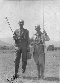
Unknown man with Mr Douglas Jardine, artist, circa 1920s - 1930s. A well know destination for fishermen and artists.Mr Jardine was an artist circa 1920s - 1930s. He stayed at the Bogong Hotel and painted landscapes of the Kiewa River etc. Visitors often paid board with their paintings.Old sepia photo attached to cardboard. Two men each with fishing lines.tawonga pub, douglas jardine, fishermen in the kiewa river -
 Kiewa Valley Historical Society
Papers - History of Schools in the Kiewa Valley
Education in the Kiewa Valley began with small schools in many locations enabling the children from the farms to attend their nearby school. As the number of children decreased and transport improved the schools were consolidated into fewer schools located in a centralised position.The history of each school gives an insight into the surrounding population - their numbers, occupations and lifestyle as well as their involvement in the running of the schools eg. Mothers' Clubs etc.8 groups of foolscap size papers stapled or pinned together each with the heading 'School History'. The first 4 are the same - "Mt Beauty School'. There is one for 'Mt Beauty High School', One for 'Mullindoligong School', One for 'Tawonga School'.One for 'Tawonga South School'.kiewa valley education, schools in the kiewa valley -
 Kiewa Valley Historical Society
Photos - Mt Beauty Schools
Mt Beauty HES school was created for the children of the employees of the State Electricity Commission of Victoria who were constructing the Kiewa Hydro Electric Scheme at the head of the Kiewa Valley at the new town of Mount Beauty. Mt Beauty School consisted of Mt Beauty Higher Elementary School 1948-1964 before it was split into the current (2023) Mt Beauty Primary School and Mt Beauty High School. See. "Kiewa Kids" by Graham Gardner pages 94-180. "Below Bogong-A History of Mount Beauty" compiled by Di Edmondson. chapter 7, Pages 178-230.As the population changed so did the schools in name, size etc. Also what started as a very modern school in the 1948 to what is now an older style wooden building2 larger photos 1 b & w - hurdles race and 1 colored 3 girls sitting in front of computers 9 medium size photos 1 b & w students and 1 of car; 1 of school building and 1 of student group; 5 coloured sports daymt beauty higher elementary school -
 Kiewa Valley Historical Society
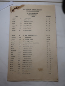
Papers - Mt Beauty Householders c 1959, SECV Kiewa Hydro Electric Scheme Householders
Mt Beauty was a construction town built by the State Electricity Commission of Victoria during construction of the Kiewa Hydro Electric Scheme from the late 1940s to 1961This is a list of the original occupiers of the homes in Mt Beauty township. Houses were allocated to teachers, medical staff etc. as well as to SEC workers.14 foolscap papers. Title SECV, KHES, Mt Beauty Householders, Alphabetical List, Name, Address and Sec/Allot. See KVHS 1264mt beauty residents, mt beauty householders, secv employees -
 Kiewa Valley Historical Society
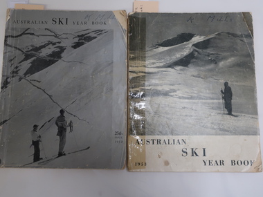
Books - Australian Ski Year Books 1952 and 1953, Australian Ski Year Book 1952 and 1953
In the early 1950s snow skiing was becoming more popular as indicated by these two books of 94 pages covering the snow fields in N.S.W., Victoria and Tawmania. The first publication was limited to the Kosciusko Alpine Club in 1928. The 1952 edition being the 25th issue. Due to the construction of the Kiewa Hydro Electric Scheme many SECV employees had access to the Bogong High Plains including Falls Creek. These books are of historical value as indicated by the advertisements for the resorts, the equipment in the snow eg. tows, skis and clothes being used at the time, the results of ski races, etc. The accommodation has also developed and attracted a variety of people. The articles include disasters, people involved in the sport and overseas updates. In the 1952 book relevant pages for the Bogong High Plains and Falls Creek are pages 36, 38, and 68-69. In the 1953 book relevant pages are 62 and 71-72 and for aborigines 66 - 69Both books have a greyish photo as a cover with the title and year. Each book has 94 pages of soft paper. The books consist of advertisements, a Contents page and articles. Photos and diagrams are in black and white. On the front covers is written: "K. Mills"bogong high plains, skiing, falls creek, aborigines -
 Kiewa Valley Historical Society
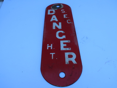
Sign - "S.E.C./Danger"
Safety signs are important to warn people of dangers. The SEC constructed the Kiewa Hydro Electric Scheme and used appropriate signs for the safety of its workers and the public.The Kiewa Hydro Electric Scheme was constructed on the Bogong High Plains and included the town of Mt Beauty for accommodation etc. for its workers.White vertical print with red background on oval shaped tin sign. There is a hole at the top and bottom for attaching the sign with a nail.state electricity commission of victoria, safety sign -
 Kiewa Valley Historical Society
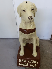
Collection Guide Dog (A) and Award Pennant (B)
The Upper Kiewa Valley Lions Club sponsored a Collection Guide Dog. Money was collected regularly by Guide Dog volunteers. The funds are used for Guide dog training programs. They are trained to guide a person who has low vision, disability or illness. It began in the 1950s and by 1957 there was a guide dog organisation in each Australian state .UKV Lions club was active in the Kiewa Valley raising money for charities eg. Blind Institute. Collection dogs were used as a novel way to collect money and easily supported by businesses etc. In 2024, our society is becoming cashless creating a problem for collection dogs etc. with donations more often made by internet banking.A) Light coloured 'plastic'/'ceramic' labrador dog with a brown strap, a money slot is on the top of his head, and he is sitting on a brown stand. B) Cloth Pennant is triangular and long mostly white (dirty) with blue print and logo and a blue border. The end for attaching is of purple bias binding with two hooks for attaching to a stand. B) Pennant: 'Royal Guide Dogs Association / Mobility/ '78 / For the Blind / Community/ Service Award'guide dogs, upper kiewa valley lions club, fund raising, blind people -
 Kiewa Valley Historical Society
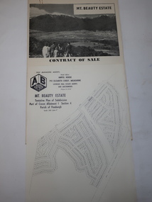
Folder - Mt Beauty Estate
After the State Electricity of Victoria completed the construction of the Kiewa Hydro Electric Scheme in 1961 the township of Mt Beauty was sold. The Shire of Bright (currently Alpine Shire) purchased the town and individual houses were put up for sale to the public.The sale of Mt Beauty changed the town - its occupants, its industry, its governance etc. Papers held in a manila folder. They include the Contract of Sale and Maps of Mt Beauty 1961mt beauty township, shire of bright -
 Kiewa Valley Historical Society
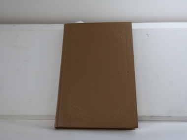
Book - Albury Almanac 1878, The Border Post published by Affleck and Gray
Published as a summary of 1878 newspaper's contentHistorical with samples for 1878 advertising, articles etc. in the Albury newspaper.Small light brown hard cover book 122 pages. Black print on cream colored pages. Each page has 'Border Post Almanac' in fancy print at the top, centre in a 'box'. Cover is embossed around the perimeter and in the corners.First page in ink "2-8-1979 / $11.75" and a stamp: "Kiewa Valley / Historical Society"albury almanac, border post, 1878 newspapers -
 Kiewa Valley Historical Society
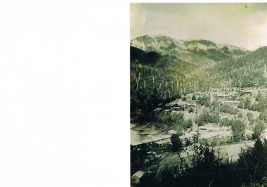
Photograph Bogong Township, Bogong Township Circa 1940s right side view, circa 1950
The Bogong Township (circa 1930s) was constructed by The State Electricity Commission of Victoria as a base camp for construction workers under the Kiewa Hydroelectric Scheme starting in 1938. The Scheme employed 4000 men during its construction phase. A small number were first housed at Bogong Village and when required the Mount Beauty Township was established(1949). Construction at the dams and Power Stations was interrupted during World War II. June 1951 started construction at full pace. The Bogong Township was developed firstly as an accommodation centre (base camp) for construction workers employed under the Kiewa Hydroelectric Scheme. Due to the influx of European workers into the Township the beautification of the immediate surrounds(gardens etc.) had a distinct European flavour. This environment has been very beneficial for tourism in later years. Strict environmental control has not allowed for any extensive redevelopment in tourist accommodation and basically restricted it to the accommodation initially built for the construction workers. Activities such a bike riding, snow skiing, restricted horse riding and bush walking on the Alpine plains and mountains are now a viable part of the Kiewa Valley Tourist Industry.Scanned copy of original black and white photo. Paper manufacturer is Kodak. Paper is Kodak XtraLife II.On reverse side "Kodak ExtaLife II paper"bogong village, bogong township, sec alpine constructions, victorian alpine tourism, winter sports. -
 Kiewa Valley Historical Society
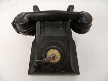
Telephone - Pre Number Dialling
This phone was used at the Mt Beauty Primary School.Historical: The SEC used a switchboard to connect people in Mt Beauty and their workers stationed throughout the Kiewa Hydro Scheme. This phone enabled the Mt Beauty Primary School to ring parents etc. and for them to ring the school. Also refer to article in "This Week" Newsletter 30th June 2023 and attached to KVHS 0050Black bakelite telephone used to sit on a bench or table. Hand piece attached by a coiled wire coated with rubber. Front of telephone, in the centre, is a small handle that can be turned around in a clock wise direction - used to connect with the switchboard or, in some areas, used to connect with others by way of morse code eg. 1 big wind and 2 short winds.telephone. communications. mount beauty primary school. -
 Eltham District Historical Society Inc
Ledger, Eltham Road District. Assessment for the Year ending Oct. 14th, 1858, 1857c
The Eltham Roads Board was established in 1856. This is a unique significant record of early settlers in the Shire of Eltham. One of 6 early rate books. This is among the oldest items in the EDHS collection. An article in the Eltham and Whittlesea Shires Advertiser Friday 21 Nov 1941 Page 5 titled: District's Early History states: "The first rate book which is still in existence at the Shire Office is for the year ending October 14, 1858 and is probably the best record possible to indicate the development of the district. At the time properties were rated as follows: Cultivated land. 6d. per acre; pasture land, 1d. per acre: estimated annual value of buildings, etc., 6d in the (pound). The total amount of rate recorded for the year was (pounds)153/14/8. Properties were described as being situated at Lower Plenty, Yarra Yarra, Eltham, Lower Eltham, Kangaroo Ground, Yarra Flats, Diamond Creek and the Yarra."Ledger with printed columns: Number, Name of Occupier, Description, Where situated, Cultivated land, Pasture land, Estimated annual value of buildings, Rate, Remarks. Ledger filled out by hand with 152 entries (not alphabetically arranged). A number of blank pages are included. Copy re-bound in green hard leather look card by Arnall & Jackson Pty Ltd Brunswick, 1968 Inside cover includes a compliments slip taped to the cover from Arnall & Jackson Pty Ltd. with handwritten inscription: "Ian, I hope the hysterical society doesn't get historical about this". Organised 1968 I. Maynard Inside cover includes pasted printed note: RATE OF ASSESSMENT AS FOLLOWS: Cultivated land 6d per acre Pasture land 1 per acre Estimated Annual Value of Buildings, &c., 6d. in the Pound eltham roads board, rate book, rate payers, transaction, pioneers, settlers, 1858, assessment ledger, eltham road district, public records office victoria (prov), rate books, shire of eltham archives -
 Eltham District Historical Society Inc
Ledger, Eltham Road District. Assessment for the Year ending Oct. 14th, 1859, 1858c
The Eltham Roads Board was established in 1856. This ledger includes the signature of Road Board Secretary and Collector Wingrove, a significant person in Eltham's early history. This is a unique significant record of early settlers in the Shire of Eltham. One of 6 early rate books. This is among the oldest items in the EDHS collection. An article in the Eltham and Whittlesea Shires Advertiser Friday 21 Nov 1941 Page 5 titled: District's Early History states: "The first rate book which is still in existence at the Shire Office is for the year ending October 14, 1858 and is probably the best record possible to indicate the development of the district. At the time properties were rated as follows: Cultivated land. 6d. per acre; pasture land, 1d. per acre: estimated annual value of buildings, etc., 6d in the (pound). The total amount of rate recorded for the year was (pounds)153/14/8. Properties were described as being situated at Lower Plenty, Yarra Yarra, Eltham, Lower Eltham, Kangaroo Ground, Yarra Flats, Diamond Creek and the Yarra."Ledger with printed columns: Number, Name of Occupier, Description, Where situated, Cultivated land, Pasture land, Estimated annual value of buildings, Rate, Remarks, Arrears collected, excused, unoccupied, uncollected and amount actually collected. Ledger filled out by hand with 173 entries (not alphabetically arranged). A number of blank pages are included. Inside cover includes pasted printed note: RATE OF ASSESSMENT AS FOLLOWS: Cultivated land 6d per acre Pasture land 2d per acre Unalienated Pasture Land 8d per Acre Estimated Annual Value of Buildings, &c., 6d. in the Pound eltham roads board, rate book, rate payers, transaction, pioneers, settlers, wingrove, 1859, assessment ledger, eltham road district, public records office victoria (prov), rate books, shire of eltham archives -
 Eltham District Historical Society Inc
Ledger, Eltham Road District. Assessment for the Year ending Oct. 14th, 1860 (Version 1), 1859c
The Eltham Roads Board was established in 1856. This is a unique significant record of early settlers in the Shire of Eltham. One of 6 early rate books. This is among the oldest items in the EDHS collection. An article in the Eltham and Whittlesea Shires Advertiser Friday 21 Nov 1941 Page 5 titled: District's Early History states: "The first rate book which is still in existence at the Shire Office is for the year ending October 14, 1858 and is probably the best record possible to indicate the development of the district. At the time properties were rated as follows: Cultivated land. 6d. per acre; pasture land, 1d. per acre: estimated annual value of buildings, etc., 6d in the (pound). The total amount of rate recorded for the year was (pounds)153/14/8. Properties were described as being situated at Lower Plenty, Yarra Yarra, Eltham, Lower Eltham, Kangaroo Ground, Yarra Flats, Diamond Creek and the Yarra."Ledger with printed columns: Number, Name of Occupier, Description, Where situated, Cultivated land, Pasture land, Estimated annual value of buildings, Rate, Remarks, Arrears collected, excused, unoccupied, uncollected and amount actually collected. Ledger filled out by hand with 177 entries (not alphabetically arranged). A number of blank pages are included. Inside cover includes pasted printed note: RATE OF ASSESSMENT AS FOLLOWS: Cultivated land 6d per acre Pasture land 2d per acre Unalienated Pasture Land 8d per Acre Estimated Annual Value of Buildings, &c., 6d. in the Pound eltham roads board, rate book, rate payers, transaction, pioneers, settlers, wingrove, 1860, assessment ledger, eltham road district, public records office victoria (prov), rate books, shire of eltham archives -
 Eltham District Historical Society Inc
Ledger, Eltham Road District. Assessment for the Year ending Oct. 14th, 1860 (Version 2), 1859c
The Eltham Roads Board was established in 1856. This is a unique significant record of early settlers in the Shire of Eltham. One of 6 early rate books. This is among the oldest items in the EDHS collection. An article in the Eltham and Whittlesea Shires Advertiser Friday 21 Nov 1941 Page 5 titled: District's Early History states: "The first rate book which is still in existence at the Shire Office is for the year ending October 14, 1858 and is probably the best record possible to indicate the development of the district. At the time properties were rated as follows: Cultivated land. 6d. per acre; pasture land, 1d. per acre: estimated annual value of buildings, etc., 6d in the (pound). The total amount of rate recorded for the year was (pounds)153/14/8. Properties were described as being situated at Lower Plenty, Yarra Yarra, Eltham, Lower Eltham, Kangaroo Ground, Yarra Flats, Diamond Creek and the Yarra."Ledger with printed columns: Number, Name of Occupier, Description, Where situated, Cultivated land, Pasture land, Estimated annual value of buildings, Rate, Remarks, Arrears collected, excused, unoccupied, uncollected and amount actually collected. Ledger filled out by hand with 177 entries (not alphabetically arranged). A number of blank pages are included. This version was slight changes to version one. Inside cover includes pasted printed note: RATE OF ASSESSMENT AS FOLLOWS: Cultivated land 6d per acre Pasture land 2d per acre Unalienated Pasture Land 8d per Acre Estimated Annual Value of Buildings, &c., 6d. in the Pound eltham roads board, rate book, rate payers, transaction, pioneers, settlers, 1860, assessment ledger, eltham road district, public records office victoria (prov), rate books, shire of eltham archives -
 Eltham District Historical Society Inc
Ledger, Eltham Road District. Assessment for the Year ending Oct. 14th, 1861, 1860c
The Eltham Roads Board was established in 1856. This is a unique significant record of early settlers in the Shire of Eltham. One of 6 early rate books. This is among the oldest items in the EDHS collection. An article in the Eltham and Whittlesea Shires Advertiser Friday 21 Nov 1941 Page 5 titled: District's Early History states: "The first rate book which is still in existence at the Shire Office is for the year ending October 14, 1858 and is probably the best record possible to indicate the development of the district. At the time properties were rated as follows: Cultivated land. 6d. per acre; pasture land, 1d. per acre: estimated annual value of buildings, etc., 6d in the (pound). The total amount of rate recorded for the year was (pounds)153/14/8. Properties were described as being situated at Lower Plenty, Yarra Yarra, Eltham, Lower Eltham, Kangaroo Ground, Yarra Flats, Diamond Creek and the Yarra."Ledger with printed columns: Number, Name of Occupier, Description, Where situated, Cultivated land, Pasture land, Estimated annual value of buildings, Rate, Remarks, Arrears collected, excused, unoccupied, uncollected and amount actually collected. Ledger filled out by hand with 185 entries (not alphabetically arranged) and summary section. A number of blank pages are included. Inside cover includes pasted printed note: RATE OF ASSESSMENT AS FOLLOWS: Cultivated land 6d per acre Pasture land 2d per acre Unalienated Pasture Land 8d per Acre Estimated Annual Value of Buildings, &c., 6d. in the Pound eltham roads board, rate book, rate payers, transaction, pioneers, settlers, 1861, assessment ledger, eltham road district, public records office victoria (prov), rate books, shire of eltham archives -
 Eltham District Historical Society Inc
Ledger, Eltham Road District. Assessment for the Year ending Oct. 14th, 1862, 1861c
The Eltham Roads Board was established in 1856. This is a unique significant record of early settlers in the Shire of Eltham. One of 6 early rate books. This is among the oldest items in the EDHS collection. An article in the Eltham and Whittlesea Shires Advertiser Friday 21 Nov 1941 Page 5 titled: District's Early History states: "The first rate book which is still in existence at the Shire Office is for the year ending October 14, 1858 and is probably the best record possible to indicate the development of the district. At the time properties were rated as follows: Cultivated land. 6d. per acre; pasture land, 1d. per acre: estimated annual value of buildings, etc., 6d in the (pound). The total amount of rate recorded for the year was (pounds)153/14/8. Properties were described as being situated at Lower Plenty, Yarra Yarra, Eltham, Lower Eltham, Kangaroo Ground, Yarra Flats, Diamond Creek and the Yarra."Ledger with printed columns: Number, Name of Occupier, Description, Where situated, Cultivated land, Pasture land, Estimated annual value of buildings, Rate, Remarks, Arrears collected, excused, unoccupied, uncollected and amount actually collected. Ledger filled out by hand with 184 entries (not alphabetically arranged) and summary section. A number of blank pages are included. Inside cover includes pasted printed note: RATE OF ASSESSMENT AS FOLLOWS: Cultivated land 6d per acre Pasture land 1/2d per acre Unalienated Pasture Land 1/28 per Acre Estimated Annual Value of Buildings, &c., 6d. in the Pound eltham roads board, rate book, rate payers, transaction, pioneers, settlers, 1862, assessment ledger, eltham road district, public records office victoria (prov), rate books, shire of eltham archives -
 Eltham District Historical Society Inc
Ledger, Eltham Road District. Assessment for the Year ending Oct. 14th, 1863, 1862c
The Eltham Roads Board was established in 1856. This is a unique significant record of early settlers in the Shire of Eltham. One of 6 early rate books. This is among the oldest items in the EDHS collection. An article in the Eltham and Whittlesea Shires Advertiser Friday 21 Nov 1941 Page 5 titled: District's Early History states: "The first rate book which is still in existence at the Shire Office is for the year ending October 14, 1858 and is probably the best record possible to indicate the development of the district. At the time properties were rated as follows: Cultivated land. 6d. per acre; pasture land, 1d. per acre: estimated annual value of buildings, etc., 6d in the (pound). The total amount of rate recorded for the year was (pounds)153/14/8. Properties were described as being situated at Lower Plenty, Yarra Yarra, Eltham, Lower Eltham, Kangaroo Ground, Yarra Flats, Diamond Creek and the Yarra."Ledger with printed columns: Number, Name of Occupier, Description, Where situated, Cultivated land, Pasture land, Estimated annual value of buildings, Rate, Remarks, Arrears collected, excused, unoccupied, uncollected and amount actually collected. Ledger filled out by hand with 181 entries (not alphabetically arranged) and summary section. A number of blank pages are included. Inside cover includes pasted printed note: RATE OF ASSESSMENT AS FOLLOWS: Cultivated land 6d per acre Pasture land 1/2d per acre Unalienated Pasture Land 1/28 per Acre Estimated Annual Value of Buildings, &c., 6d. in the Pound eltham roads board, rate book, rate payers, transaction, pioneers, settlers, 1863, assessment ledger, eltham road district, public records office victoria (prov), rate books, shire of eltham archives -
 Warrnambool and District Historical Society Inc.
Program, Home & Family Week 1953, 1953
As the photograph on the front page of this pamphlet suggests, the ‘Home & Family Week’ activities may have been inspired by the Coronation of Queen Elizabeth in England. The program for the week included exhibitions, speakers, musical entertainments, a church service, children’s films, public meetings, discussion groups and a youth tea. A committee was formed in Warrnambool to organize the week’s events and the Chairman was Mr Lindsay Anderson.This program is of interest because it gives us details of an event that was staged in Warrnambool in 1953 – Home & Family Week. Many of the speakers and chairpersons for the activities of Home & Family Week were well-known people in the Warrnambool community at the time – Dr H. Holmes, Edith Jacobs, Rupert Philpott, Mrs J.O. Tait, Dr Brauer, Mr E. Willison, Arnold Westgarth etc. This is a pamphlet - one sheet folded in two to make six pages. It has the program for Home & Family Week held in Warrnambool in 1953. The program has blue printing on a beige background. The front page has a photograph in blue and white tonings of Queen Elizabeth, Prince Philip and their two children. As well as the program details the pamphlet contains profiles on some of the speakers and chairpersons and a page promoting the ideas behind the presentation of the week’s sessions.home & family week,, warrnambool, history of warrnambool -
 Warrnambool and District Historical Society Inc.
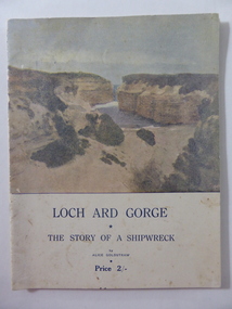
Book, Loch Ard Gorge, Early 20th century
This is a booklet containing an epic-style poem by Alice Goldstraw on the subject of the wreck of the ‘Loch Ard’. Alice Goldstraw (died 1967) was the daughter of George and Robina Goldstraw who were pioneer farmers in the Cudgee area. The Goldstraw families were prominent in the early history of Warrnambool and district, especially as timber millers. The ‘Loch Ard’ wreck (1878, Mutton Bird Island near Port Campbell) is Victoria’s most famous wreck – 51 lives lost with only two survivors. The story of the survivors, Eva Carmichael and Tom Pearce has legendary status in the stories of shipwrecks in Victoria and has been the subject of articles, songs, poems, plays, novels and films. This booklet is of great significance because it is a well-written poem by Alice Goldstraw, a member of a pioneer family in the Cudgee area. It is a notable early poem about the wreck of the ‘Loch Ard’ which has attracted much interest in the Warrnambool area and beyond. Flagstaff Hill Maritime Museum in Warrnambool specializes in promoting stories of this wreck and features many relics of the wreck in its collection – the Loch Ard Peacock, the Carmichael watch, the Tom Peace binoculars etc. The laser night show at this Museum currently features the story of the wreck. Original copies of this poem are now rare.This is a soft cover booklet of 20 pages containing a poem about the wreck of the ‘Loch Ard’. The cover is cream-coloured with the front cover having blue print and a sepia-coloured photograph of the Loch Ard Gorge. The booklet has a page of photographs connected to the ‘Loch Ard’ and an ornamental black border around each page of the stanzas. The front cover is somewhat blotched and stained. The booklet has been stapled but the staples have been removed.poetry, loch ard shipwreck, warrnambool authors, alice goldstraw, warrnambool history -
 Flagstaff Hill Maritime Museum and Village
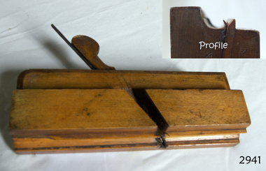
Tool - Wood Moulding Plane, Routledge, 1869-1910
A moulding plane is a specialised plane used for making the complex shapes found in wooden mouldings that are used to decorate furniture or other wooden object. Traditionally, moulding planes were blocks of wear resistant hardwood, often beech or maple, which were worked to the shape of the intended moulding. The blade, or iron was likewise formed to the intended moulding profile and secured in the body of the plane with a wooden wedge. A traditional cabinetmakers shop might have many, perhaps hundreds, of moulding planes for the full range of work to be performed. Large crown mouldings required planes of six or more inches in width, which demanded great strength to push and often had additional peg handles on the sides, allowing the craftsman's apprentice or other worker to pull the plane ahead of the master who guided it. All we known about Richard Routledge is that he was a tool maker and retailer that operated a business at either 23 or 64 Bull St Birmingham between 1869 to sometime in the early 20th century. There are many of his tools including decorative moulding planes of all sizes and designs for sale around the world and that his tools in particular moulding planes are well sought after by collectors of vintage tools. A vintage tool made by an early tool manufacturer Richard Routledge, this item was made commercially for firms and individuals that worked in wood and needed a tool that could produce an ornamental finish to timber. The tool was used before routers and spindle moulders came into use after World War ll, a time when to produce a decorative moulding for a piece of furniture, door trims etc. or other items had to be accomplished using hand tools and in particular one of these types of planes. These profiled planes came in various shapes and sizes to achieve a decorative finish. A significant tool from the mid to late 19th century by a known maker that today is quite rare and sought after by collectors. It gives us a snapshot of how furniture and other decorative finishes were created on timber by the use of hand tools. Tools that were themselves handmade shows the craftsmanship used during this time not only to make a tool such as the subject item but also the craftsmanship needed to produce a decorative finish that was needed to be made for any timber item. Moulding Plane Side Bead 5/8 type with a single Box 5/8" "Routledge Birmingham " also inscribed "J.A.S. Burden" (owner of the plane)flagstaff hill, warrnambool, flagstaff hill maritime museum, maritime museum, shipwreck coast, great ocean road, plane, moulding, routledge, side bead, single box, moulding plane, richard routledge, jas burten -
 Flagstaff Hill Maritime Museum and Village
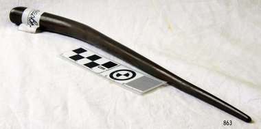
Tool - Marlin Spike, Unknown possibly washed up from a wreck late 19th century
A marlinspike is a tool used in marine rope work it is shaped in the form of a polished metal cone tapered to a rounded or flattened point, it is used in such tasks as unlaying rope for splicing or untying knots. For drawing a marline tight and using a marlinspike hitch as well as for joining toggle ropes under tension in a belaying pin splice. Most marlin spikes are 15–30 cm long, but may reach 61 cm and more for working heavy cables and ropes. They are usually made from iron or steel, whereas fids, similar in shape and function, are formed from wood or bone. The marlinspike may be a separate tool or as an item on a pocket knife. Sailors who become proficient at knot tying, splicing, and sewing using the marlinspike are said to have mastered marlinespike seamanship, earning them the right to be known as marlin spikes or marlinspike seamen.A tool still very much in use today wherever a rope or cable requires joining, splicing etc the marlin spike tool design has not changed since first invented centuries ago as a sailors tool to splice and make repairs to ropes and cables on board a ship. This item gives a snapshot into the life sailors have on board sailing vessels past and present. Marlin Spike made of solid steel. Handle is bulbous and spike end is rounded.flagstaff hill, warrnambool, shipwrecked-coast, flagstaff-hill, flagstaff-hill-maritime-museum, maritime-museum, shipwreck-coast, flagstaff-hill-maritime-village, marlin spike -
 Flagstaff Hill Maritime Museum and Village
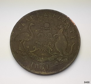
Currency - Coin, Robert Hyde & Co. Shipping Merchants, 1861
The donor (a local resident.) of this coin found this penny token coin in the sand dunes of Lady Bay, Warrnambool, in 2023. The coin could have come from a local shipwreck, passengers, or members of the community. Trade was carried out along the southwest coast of Victoria between Melbourne and Portland, with the Port of Warrnambool receiving passengers and goods by coastal traders, the steamboat that set off from ports every few days. One such vessel was the steamship SS Edina that made her first voyage from Melbourne to Portland in 1863. For around a decade or so in the Gold Rush period in Australia there was a shortage of official government currency. It was acceptable during this time to use token coins minted by local businesses to be used within their store, much like the loyalty and rewards cards that businesses give their customers in modern times. The tokens were also a good way to advertise their wares and details. The first token was introduced in Melbourne in 1848 and were used until 1868, when they became illegal in New South Wales. They were minted in Australia and overseas. The token was issued by Robert Hyde & Co. who traded in second-hand goods such as old clothes, sheets, metal items and glass, which they resold to be re-manufactured, or "recycled".A token such as this one identifies businesses existing in the post-Gold Rush period in Australia. Round copper coin. Penny token coin bearing the Australian Coat of Arms and motto. The coin also has the company's name, location, nature of business and motto. The coin has grooves around the edge. It was made in 1861.OBVERSE: Logo: (Australian Coat of Arms), Motto: "PEACE & PLENTY", Date: 1861 REVERSE: "ROBERT HYDE & CO MELBOURNE", "GENERAL MARINE STORE, SHIPPERS OF RAGS GLASS METALS &.C"flagstaff hill maritime museum and village, warrnambool, great ocean road, shipwreck coast, merchant token, melbourne, token, australian token, trade token, coins, merchants, medal, colonisation, gold rush, robert hyde & co., general marine store, shippers of rags glass metals etc., numismatics, second-hand scrap, scrap goods -
 Glen Eira Historical Society
Ephemera - Rotary Club of Elsternwick
This file contains two items relating to the Rotary Club of Elsternwick: 1/Changeover dinner program held 02/07/1998 for incoming president. 2/Pamphlet for the first Annual Wine and Food Expo held 15/07/1998.rotary club of elsternwick, st. georges road, murphy chris, fitzgerald gerry, meehan john, bird jeffrey, sanicki claude, harris. christine, anderson sandy, jackson adrian, reidy brendan, waratah cellars, glenhuntly road, mailboxes etc, clubs and associations, events and activities, eating and drinking, festivals and celebrations, shows and exhibitions, elsternwick station -
Federation University Historical Collection
Booklet - Register, Record of War Service Old Boys of Junior Technical School Ballarat
This listing was probably made after World War One around 1919The information includes rank, service (AIF, RAAF etc) and if Killed in Action.Cream foolscap black lined 36 double sided pages with alphabet tags cut in at the side being an alphabetical listing of Ballarat Junior Technical School Old Boys War War Two Service. Six holes are punched in the left hand side with three brass fastenings. Handwritten names. ABC ... Z, incomplete data, cannot trace, at right hand side. world war two, ballarat junior technical school, jtsb, bjts, war service, old boys, ballarat, soldiers, airman, honour roll, ww2, wwii, aif, raaf, airforce, avy, norman barnett, francis capuano, leslie coad, robert (stewart) sunstan, stanley dunstan, clifford l. dunstan, ran, james g. dunstan, f.m. hassell, robert kneeshaw, william knight, maxwell little, francis j. longhurst, norman w. ludbrook, ronald j. ludbrook, roy martin, albert francis mayne, leonard a. moy, albert edward phillipsharold l. pittard, j.p. rodgers, ian rands, noel george sandland, john w. scott, francis spilvogel -
 Federation University Historical Collection
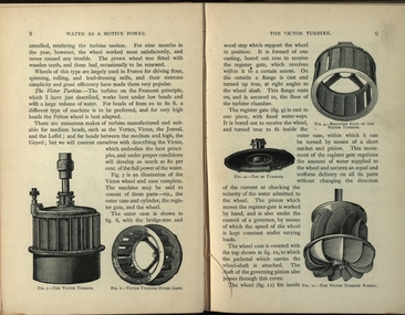
Book, Machinery for Metalliferous Mines, 1894, 1894
The 1st edition of this famous work, giving an excellent account of the machinery used in late 19th century metal mining in the UK and overseas is very rare. It covers a wide range of equipment - pumps, steam engines, drills, winding engines, stamps & concentration mills, aerial ropeways, tramways and early uses of electricity etc. Brown hard cloth covered book. xvi 564 pages with additional advertisements, with over 300 illustrations and drawings, some fold out. Chapters include Water as a motive power, Wind engines and ventilating machinery, Steam boilers/engines and oil engines, hoisting machinery, draining of Mines, pumping engines, rock drilling machinery, boring machinery, concentration machinery, sizing and classifications trommels, joggers and jigging, fine concentration, milling of gold ores, milling of silver ores, amalgamation plates and machinery, dry and roasting machinery, chlorination and cyandide processes for the extraction of gold, electricity as a motive power for mining, electric lighting and blasting, aerial wire ropeways, transport by rail and road. There a a number of lovely line illustrations in the book including: Poncelot's undershot waterwheel; Fromont furnace;Victor turbine; Pelton waterwheel; Root's positive blower;Cross section and front elevation of Lancashire boiler; Robey's Compound Mill Engine; Portable Winding Plant; Iron Pit Head Gear ; Loading Arrangement in an Incline Shaft; kibble; Worthington Pump; California Pump; Scram's Air Compressor; Rock drill Bits; Special Sharpening tools; Boring tools;Rotating Picking table; Ore Feeder; roller crusher; stamp battery; round buddle; slime table; vanner; amalgamating plant; belt elevator;roasting furnace;splicing wire rope; capel; tipping waggon;mining, cornish pump, linkenbach table, water wheel, ventilation, oil engine, california, america, water, steam boilers, steam engines, oil engines, pumpimg, rock drilling, boring, jiggers, milling, silver, gold, drying and roasting, chlorination, cyaniding, lead, zinc, copper, electricity, electric lighting, wire ropes, transport, wind engine, poppet head -
![Postcard - photographic, A. Gordon Spittle [and Harry Holmes?] , 1916, 23/03/1916](/media/collectors/4f729f6797f83e0308601707/items/4ffe16342162ef0da4e1a9a6/item-media/4ffe169c2162ef0da4e1a9bc/item-fit-380x285.jpg) Federation University Historical Collection
Federation University Historical CollectionPostcard - photographic, A. Gordon Spittle [and Harry Holmes?] , 1916, 23/03/1916
Gordon Spittle was the youngest of Three brothers. He grew up in Creswick and attended Creswick Grammar School. Gordon purchased 'Mt Cavern' in 1912. It had 4 years of a 10 year lease to run. His mother and father took delivery of it on 1 April 1916. They lived there and farmed it until Gordon returned from active service in May 1919. S. Gordon Spittle married Violet Holmes and both lived at "Mt Cavern" until their deaths. Gordon died in 1942 aged 51. Violet Holmes-Spittle died in 1949 aged 56. Handwritten lower front 'Do we look down hearted?' Handwritten verso 'Egypt, March 23rd 1916. Dear Mrs Troup. Your very fine and interesting letter dated Feb 15th came to hand to-day and needless to add was delighted to receive it, and can promise you that I'll answer it at my earliest opportunity. We are now having a better time since we came to this part, as we are able to enjoy a little of city life, although we have a good deal more work to do, & which is mostly carting goods to & from the ships & railway stations etc, all of which is interesting & quite a change from our life on the Desert. Hope this card finds you in good health. I will now have to say au revoir for the present with kindest regards to Mr Troup, self and family. From your very sincere friends, A. Gordon Spittle."Two uniformed Australian soldiers pose for a photograph during World War One.chatham family archive, chatham, holmes, world war, world war 1, world war i, world war one, france, spittle, gordon spittle -
 Flagstaff Hill Maritime Museum and Village
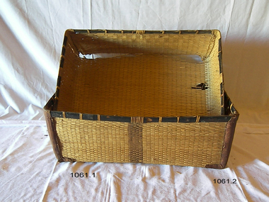
Domestic object - Basket, 1890-1920s
Before the invention of woven baskets, people used tree bark to make simple containers. These containers could be used to transport gathered food and other items but crumbled after only a few uses. Weaving strips of bark or other plant material to support the bark containers would be the next step, followed by entirely woven baskets. The last innovation appears to be baskets so tightly woven that they could hold water. Depending on soil conditions, baskets may or may not be preserved in the archaeological record. Sites in the Middle East show that weaving techniques were used to make mats and possibly also baskets, circa 8000 BCE. Twined baskets date back to 7000 in Oasisamerica. Baskets made with interwoven techniques were common at 3000 BCE. Baskets were originally designed as multi-purpose vessels to carry and store materials and to keep stray items about the home. The plant life available in a region affects the choice of material, which in turn influences the weaving technique. Rattan and other members of the Arecaceae or palm tree family, the thin grasses of temperate regions, and broad-leaved tropical bromeliads each require a different method of twisting and braiding to be made into a basket. The practice of basket making has evolved into an art. Artistic freedom allows basket makers with a wide choice of colours, materials, sizes, patterns, and details.Before the advent of plastics (1907), the is now used for many different types and styles of storage container rattan, wicker or cane was used to make containers with a lid for the storage of linens etc. The subject item was probability used at the end of the Victorian era and into the Edwardian period around the 1900s as a household storage facility. These types of wicker or cane containers started to go out of fashion due to their fragility around the 1920s into the 1940s due as well to the introduction of synthetic materials. Wicker cane rectangular shaped domestic storage container with reinforced leather pads on 4 corner sides. lid fits inside the other. Black cane piece around top edge.Noneflagstaff hill, warrnambool, shipwrecked-coast, flagstaff-hill, flagstaff-hill-maritime-museum, maritime-museum, shipwreck-coast, flagstaff-hill-maritime-village