Showing 4924 items matching "shorter"
-
 Eltham District Historical Society Inc
Photograph, Russell Yeoman, Fitzsimons Lane Bridge over Yarra River between Eltham and Templestowe, c.1970, 1970c
The bridge over the Yarra River was initially opened September 22nd, 1961. Newspaper reports at the time of opening stated it linked Bolton Street, Eltham, with Fitzsimons Lane, Templestowe. In 1955 the Country Roads Board (CRB) produced survey plans that showed proposed land acquisition for the future bridge and road approaches. The 1955 plan shows that it was proposed to connect Fitzsimons Lane with Bolton Street in Eltham by a diagonal road across the river. The road connection would then continue along Bolton Street to Main Road. Prior to construction of the bridge the CRB modified the proposal significantly so that there was a new road parallel with Bolton Street and then curving to join Main Road at what was then its intersection with Old Eltham Road. This involved significantly more land acquisition and altered the pattern of land subdivision through this corridor. Initially the new road was just a single two-way carriageway as it would have required a significant widening of the cutting on the Shire of Eltham side of the river. The road was officially un-named but was known locally as the Eltham-Templestowe Road. The 1966 Melway street directory and other 1960s editions also listed the road as the Eltham-Templestowe Road. In December 1970, Eltham Shire Council, in pursuance of the provisions of the Local Government Act, named it Templestowe Road. The road was renamed Fitzsimons Lane around 1984 in conformity with the section south of the river. In 1991 a new bridge was built to the west of the original bridge. Fitzsimons Lane was widened to four traffic lanes although on the Eltham side this was done within the limits of the existing cutting. NEW BRIDGE STARTS THEM EXPLORING Without any fanfares, Country Roads Board workmen on Friday afternoon put the finishing touches to the approaches, removed the barricades, and let the traffic roll over the new Yarra bridge linking Bolton Street, Eltham, with Fitzsimons Lane, Templestowe. Over the week-end many “bridge watchers” who were making one of their periodic inspections of the progress on the new bridge found to their surprise that they could drive over it, so that people who had gone for a run out to Eltham suddenly found themselves wandering through Templestowe and Doncaster. By Monday the word of the bridge’s opening had got around sufficiently for many regular travellers to the city from Eltham and beyond to vary the monotony by going to town via Templestowe and Kew instead of through Heidelberg. They were surprised at the distances – about 3 ½ miles from Eltham to Templestowe, 6 miles from Eltham Shire hall to the Lower Heidelberg Road-Banksia Street intersection. NEW NEIGHBOURS For people on both sides of the river, the new bridge has turned distant friends into near neighbours. A Greensborough man on Sunday took 35 minutes to reach the home of a friend in East Doncaster, but the return trip over the new bridge took only 17 minutes. It will be some time yet before most people work out the possibilities in shorter and quicker trips form the north-eastern areas to the eastern and south-eastern suburbs. The coming of the warmer months will soon teach many, though the short cuts to Peninsular beaches and eastern suburban drive-ins. And before very long it is likely there will be a Tramways bus running from Templestowe to Eltham station. NEW BRIDGE STARTS THEM EXPLORING (1961, September 27). The Diamond Valley News (News clipping held in SEA_74-1_047) The previously un-named road between Main Road and Yarra River, Eltham South, east of Bolton Street was named Templestowe Road, December 15, 1970 NAMING OF STREETS AND ROADS. (1970, December 15). The Diamond Valley News (News clipping held in SEA_74-2_022)Roll of 35mm black and white negative film, 4 of 7 stripsIlford HP4bridge, bridges, fitzsimons lane bridge, infrastructure, shire of eltham infrastructure, yarra river -
 Eltham District Historical Society Inc
Photograph, Fitzsimons Lane Bridge over Yarra River between Eltham and Templestowe, c.1966, 1966c
The bridge over the Yarra River was initially opened September 22nd, 1961. Newspaper reports at the time of opening stated it linked Bolton Street, Eltham, with Fitzsimons Lane, Templestowe. In 1955 the Country Roads Board (CRB) produced survey plans that showed proposed land acquisition for the future bridge and road approaches. The 1955 plan shows that it was proposed to connect Fitzsimons Lane with Bolton Street in Eltham by a diagonal road across the river. The road connection would then continue along Bolton Street to Main Road. Prior to construction of the bridge the CRB modified the proposal significantly so that there was a new road parallel with Bolton Street and then curving to join Main Road at what was then its intersection with Old Eltham Road. This involved significantly more land acquisition and altered the pattern of land subdivision through this corridor. Initially the new road was just a single two-way carriageway as it would have required a significant widening of the cutting on the Shire of Eltham side of the river. The road was officially un-named but was known locally as the Eltham-Templestowe Road. The 1966 Melway street directory and other 1960s editions also listed the road as the Eltham-Templestowe Road. In December 1970, Eltham Shire Council, in pursuance of the provisions of the Local Government Act, named it Templestowe Road. The road was renamed Fitzsimons Lane around 1984 in conformity with the section south of the river. In 1991 a new bridge was built to the west of the original bridge. Fitzsimons Lane was widened to four traffic lanes although on the Eltham side this was done within the limits of the existing cutting. NEW BRIDGE STARTS THEM EXPLORING Without any fanfares, Country Roads Board workmen on Friday afternoon put the finishing touches to the approaches, removed the barricades, and let the traffic roll over the new Yarra bridge linking Bolton Street, Eltham, with Fitzsimons Lane, Templestowe. Over the week-end many “bridge watchers” who were making one of their periodic inspections of the progress on the new bridge found to their surprise that they could drive over it, so that people who had gone for a run out to Eltham suddenly found themselves wandering through Templestowe and Doncaster. By Monday the word of the bridge’s opening had got around sufficiently for many regular travellers to the city from Eltham and beyond to vary the monotony by going to town via Templestowe and Kew instead of through Heidelberg. They were surprised at the distances – about 3 ½ miles from Eltham to Templestowe, 6 miles from Eltham Shire hall to the Lower Heidelberg Road-Banksia Street intersection. NEW NEIGHBOURS For people on both sides of the river, the new bridge has turned distant friends into near neighbours. A Greensborough man on Sunday took 35 minutes to reach the home of a friend in East Doncaster, but the return trip over the new bridge took only 17 minutes. It will be some time yet before most people work out the possibilities in shorter and quicker trips form the north-eastern areas to the eastern and south-eastern suburbs. The coming of the warmer months will soon teach many, though the short cuts to Peninsular beaches and eastern suburban drive-ins. And before very long it is likely there will be a Tramways bus running from Templestowe to Eltham station. NEW BRIDGE STARTS THEM EXPLORING (1961, September 27). The Diamond Valley News (News clipping held in SEA_74-1_047) The previously un-named road between Main Road and Yarra River, Eltham South, east of Bolton Street was named Templestowe Road, December 15, 1970 NAMING OF STREETS AND ROADS. (1970, December 15). The Diamond Valley News (News clipping held in SEA_74-2_022)Black and white photographManufacturer's marks: Polaroid, Batch #J62K181 (Sep 1966).infrastructure, shire of eltham infrastructure, bridge, fitzsimons lane bridge, polaroid, yarra river -
 Eltham District Historical Society Inc
Photograph, Fitzsimons Lane Bridge over Yarra River between Eltham and Templestowe
The bridge over the Yarra River was initially opened September 22nd, 1961. Newspaper reports at the time of opening stated it linked Bolton Street, Eltham, with Fitzsimons Lane, Templestowe. In 1955 the Country Roads Board (CRB) produced survey plans that showed proposed land acquisition for the future bridge and road approaches. The 1955 plan shows that it was proposed to connect Fitzsimons Lane with Bolton Street in Eltham by a diagonal road across the river. The road connection would then continue along Bolton Street to Main Road. Prior to construction of the bridge the CRB modified the proposal significantly so that there was a new road parallel with Bolton Street and then curving to join Main Road at what was then its intersection with Old Eltham Road. This involved significantly more land acquisition and altered the pattern of land subdivision through this corridor. Initially the new road was just a single two-way carriageway as it would have required a significant widening of the cutting on the Shire of Eltham side of the river. The road was officially un-named but was known locally as the Eltham-Templestowe Road. The 1966 Melway street directory and other 1960s editions also listed the road as the Eltham-Templestowe Road. In December 1970, Eltham Shire Council, in pursuance of the provisions of the Local Government Act, named it Templestowe Road. The road was renamed Fitzsimons Lane around 1984 in conformity with the section south of the river. In 1991 a new bridge was built to the west of the original bridge. Fitzsimons Lane was widened to four traffic lanes although on the Eltham side this was done within the limits of the existing cutting. NEW BRIDGE STARTS THEM EXPLORING Without any fanfares, Country Roads Board workmen on Friday afternoon put the finishing touches to the approaches, removed the barricades, and let the traffic roll over the new Yarra bridge linking Bolton Street, Eltham, with Fitzsimons Lane, Templestowe. Over the week-end many “bridge watchers” who were making one of their periodic inspections of the progress on the new bridge found to their surprise that they could drive over it, so that people who had gone for a run out to Eltham suddenly found themselves wandering through Templestowe and Doncaster. By Monday the word of the bridge’s opening had got around sufficiently for many regular travellers to the city from Eltham and beyond to vary the monotony by going to town via Templestowe and Kew instead of through Heidelberg. They were surprised at the distances – about 3 ½ miles from Eltham to Templestowe, 6 miles from Eltham Shire hall to the Lower Heidelberg Road-Banksia Street intersection. NEW NEIGHBOURS For people on both sides of the river, the new bridge has turned distant friends into near neighbours. A Greensborough man on Sunday took 35 minutes to reach the home of a friend in East Doncaster, but the return trip over the new bridge took only 17 minutes. It will be some time yet before most people work out the possibilities in shorter and quicker trips form the north-eastern areas to the eastern and south-eastern suburbs. The coming of the warmer months will soon teach many, though the short cuts to Peninsular beaches and eastern suburban drive-ins. And before very long it is likely there will be a Tramways bus running from Templestowe to Eltham station. NEW BRIDGE STARTS THEM EXPLORING (1961, September 27). The Diamond Valley News (News clipping held in SEA_74-1_047) The previously un-named road between Main Road and Yarra River, Eltham South, east of Bolton Street was named Templestowe Road, December 15, 1970 NAMING OF STREETS AND ROADS. (1970, December 15). The Diamond Valley News (News clipping held in SEA_74-2_022)Black and white photographinfrastructure, shire of eltham infrastructure, bridge, fitzsimons lane bridge, yarra river -
 Eltham District Historical Society Inc
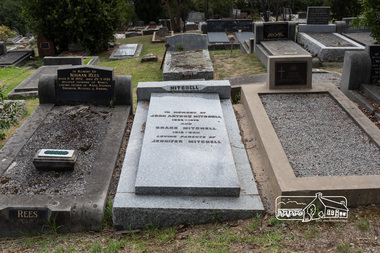
Photograph, Peter Pidgeon, Grave of John Arthur and Grace Mitchell, Eltham Cemetery, Victoria, 5 April 2021
Grace Mitchell, a talented artist in later life and baker, managed a pastry shop business near the corner of Mount Pleasant and Main roads, Eltham in the 1950s. Shortly after her marriage to Arthur Mitchell in 1948, Arthur incurred a head injury from an accident and was unable to work. Grace realised she needed to be home to care for her husband as well as earn an income. She managed the bureaucracy of council permits, and made modifications to her home with savings to get the business off the ground without having to borrow money. Grace and Arthur were avid gardeners and would grow, wash and mince vegetables for pasties while Grace handmade and rolled the pastry. They cooked and minced their own meat for the pies and the fruit for the sweet pies came from their orchard at the rear of the property. She also baked scones and cakes. With weekend visitors travelling to Eltham on the train for days trips, her reputation grew as the spot for afternoon tea. Grace’s daughter Jenni mentions the visit of dancer, Robert Helpmann and U.S. actress Katherine Hepburn in her Grace Mitchell: a short history [2012]. Reminiscences in We did open a school in Little Eltham: Eltham Primary School 209, 1856-2006 a history [2006] include a mention of Grace’s famous pastry shop and the Sunday afternoon visit by Helpmann and Hepburn. Grace operated her pastry shop for over 16 years. She supported the Shillinglaw Cottage Preservation Campaign to preserve the cottage through its Flavour of Eltham community cookbook published in 1964 and hosted cooking classes in the new Living and Learning Centre. Grace Mitchell passed away aged 95 years in 2011. In memory of John Arthur Mitchell 1905 – 1975 And Grace Mitchell 1916 – 2011 Loving parents of Jennifer MitchellBorn Digitaleltham cemetery, gravestones, grace mitchell, john arthur mitchell -
 Federation University Historical Collection
Document - Document - Information, VIOSH: Background Paper for Stakeholders Workshop, Friday 2 June 1994
Victorian Institute of Occupational Safety and Health (VIOSH) Australia is the Asia-Pacific centre for teaching and research in occupational health and safety (OHS) and is known as one of Australia's leaders on the field. VIOSH has a global reputation for its innovative approach within the field of OHS management. VIOSH had its first intake of students in 1979. At that time the Institution was known as the Ballarat College of Advanced Education. In 1990 it became known as Ballarat University College, then in 1994 as University of Ballarat. It was 2014 that it became Federation University. VIOSH Australia students are safety managers, senior advisors and experienced OHS professionals. They come from all over Australia and industry. Students are taught active research and enquiry; rather than textbook learning and a one-size fits all approach. VIOSH accepts people into the Graduate Diploma of Occupational Hazard Management who have no undergraduate degree - on the basis of extensive work experience and knowledge. The Background Paper prepared for a meeting to be held on Friday 2 May 1994. It is a Stakeholders Workshop. Information on VIOSH over the years provided. The range of OHS activities include: 1. Accredited Tertiary Courses 2. Short Courses 3. Research 4. Consultancy 5. Advisory Function 6. Information Resources The Graduate Diploma in OHM started in 1979 and was the first Occupational Health and Safety tertiary course in Australia. Since then it has continued to attract students at a national level even though similar courses were offered elsewhere. The map on Page 2 shows the extent of enrolments. The Courses Review Process is outlined and VIOSH is now able to define its own procedures and processes for reviewing its post-graduate programs.This is being managed by a small internal project management team. The "new" programs to commence in 1996.Four A4 pages, typed. Page 2 -map of Australiaviosh, victorian institute of occupational safety and health, ballarat college of advanced education, graduate diploma in ohm, stakeholders workshop, accredited tertiary courses, short courses, research, consultancy, advisory function, information resources, course review process -
 Federation University Historical Collection
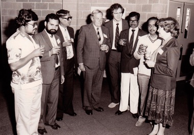
Photograph - Photograph - black and white, VIOSH: AIDAB Factory Inspectors Short Course, 1984
Victorian Institute of Occupational Safety and Health (VIOSH) Australia is the Asia-Pacific centre for teaching and research in occupational health and safety (OHS) and is known as one of Australia's leaders on the field. VIOSH has a global reputation for its innovative approach within the field of OHS management. VIOSH had its first intake of students in 1979. At that time the Institution was known as the Ballarat College of Advanced Education. In 1990 it became known as Ballarat University College, then in 1994 as University of Ballarat. It was 2014 that it became Federation University. VIOSH Australia students are safety managers, senior advisors and experienced OHS professionals. They come from all over Australia and industry. Students are taught active research and enquiry; rather than textbook learning and a one-size fits all approach. VIOSH accepts people into the Graduate Diploma of Occupational Hazard Management who have no undergraduate degree - on the basis of extensive work experience and knowledge. In 1984 the Health and Safety Unit conducted its first "short course". This was a three month course in industrial safety. The first group was for Australian International Development Assistance Bureau (AIDAB) Factory Inspectors. The group was made up of twelve chief inspectors and deputy inspectors from India and one inspector from Fiji. AIDAB provided the funding for those who participated - course, accommodation and fares. It continues to provide this support within the Asia-Pacific Region today. Photograph is of the welcoming luncheon for the visiting engineers, from the left. Bishwa Manujendra from Figi, V.S. Sasikumar and S Majumbar from India, BCAE president Ian Gordon, Dennis Else, course consultant from the U.K., M Deshbratar and M Prasad from India and Norma Buckman, regional director of the Australian International Development Assistance Bureau (AIDAB) which is funding the course.Black and white photographviosh, victorian institute of occupational safety and health, asia-pacific, ballarat college of advanced education, dennis else, india, fiji, aidab, australian international development assistance bureau, short course, engineers, bishwa manujendra, v s sasikumar, s majumbar, ian gordon, president of bcae, m deshbratar, m prasad, norma buckman, regional director of aidab -
 Orbost & District Historical Society
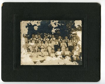
black and white photograph, Warren, Mrs H, C1900- 1910
This photograph was found in the Orbost Historical Society's cupboard. School is unknown. A copy of this photograph has been donated by Gil and Heather Richardson via the Mary Gilbert Collection. It is probably of students of Jarrahmond school where Miss Cope was the head teacher C 1916. This photograph could be associated with a celebration of Empire Day. The celebration of Queen Victoria's birthday on May 24 was renamed Empire Day in 1903 after her death in 1901. It was celebrated throughout the British Empire culminating in fireworks and bonfires in the evening. Empire Day was first introduced in 1905 to promote loyalty among the dominion countries of the British Empire. (from https://dictionaryofsydney.org/event/empire_day) Celebrated on 24 May, Queen Victoria's birthday, it was directed especially at school children. Teachers were encouraged to promote special steps to develop a feeling of pride in the British Empire and the achievements of the British race. Often a morning of short addresses, recitations and patriotic songs such as 'Rule Britannia' and 'Advance Australia' was followed by a half-day holiday to mark the celebration of Australia's strong ties to the British Empire. (from MuseumsVictoria) Some identified are; Top row -E- Eva Trewin; N-Rita Mundy; G-Elva Trewin; N- Jack Mundy D-Jack Trewin Middle row - Miss Cope, teacher. I Daisy or Katie McLeod Front row - L -Jack Stephenson; A Lindsay Trewin ; N-Frank Richardson Helena Warren was a self-taught photographer who became both the local press correspondent and a producer of humorous trompe l'oeil postcard images. The photographer, was a thirty-two year old settler living on a small mixed farm with her husband, William, at Newmerella, near Orbost in Gippsland, Victoria, when she bought her first camera, an Austral Box quarter-plate. Her family says she was entirely self-taught. Although not clearly dentified the photograph has significance in its association with Helen Frances Warren, a popular Orbost identity who was well known as an accomplished photographer and needleworker, It is associated with education in Orbost.A very old and damaged photograph of students an a teacher under a tree. The students are holding up cards that read "England, Ireland, Scotland". The photo is on a black card frame. a woman is standing on the left. Children are posed into three rows. There is also a copy of this photograph.photograph-helena-warren education-jarrahmond -
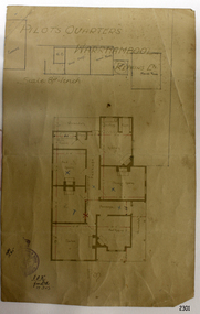 Flagstaff Hill Maritime Museum and Village
Document - Plan, Pilots Quarters Warrnambool
Warrnambool was officially made a Port of Entry in 1855 and by the 1870s had became the dominant port in the Western District. Sadly, due to an increasing problem with silting in the harbour, by the 1890s only small vessels could navigate the harbour. Men with the position of Pilot and Harbourmaster in Warrnambool were employed by the government to enforce government regulations and to help guide vessels safely into the port of Lady Bay, which was difficult to navigate. Some of the Pilots and Harbour Masters of Warrnambool were – - Captain Christopher Gwatkin, the first Harbourmaster for Warrnambool (1857 - his death in 1859). - Captain Helpman was Warrnambool’s second Harbourmaster 1859-1869 - James Nicol was Harbourmaster in Warrnambool for a time, including 1906 (b. 1840 – d. 1926) - Thomas Smith Drewett (1853 - 15-3-1905) past Captain of the Helen Nicoll, Pilot and Harbourmaster of Warrnambool. Warrnambool’s Tourist Guide of 1888 advises that “At the Port of Warrnambool there are two Leading Lighthouses. A licensed sea pilot, Captain Drewett, is stationed at the Port.” In 1915 plans for the Pilot’s Quarters were drawn up for the Department of Public Work. It was at that time, when personnel was short due to the First World War, that apparently the Pilot and Harbourmaster was also responsible for maintaining the light (lighthouse). The new Pilot and Harbourmaster’s house would be built on the site at 88 Merri Street, overlooking Lady Bay and right beside the Flagstaff and the Lady Bay Upper Lighthouse. Other Pilot and Harbourmasters were - - James Menzies was the Pilot and Harbourmaster at Warrnambool in 1929 . In 1932, he was appointed to the position of Acting Secretary to the Warrnambool Harbour Board. A hundred or so years later Flagstaff Hill Maritime Village has fully renovated the former Harbourmaster’s quarters, changed the name to Lighthouse Lodge, and is now allowing guests to stay in the home, which is still neighbour to the operational Lady Bay Lighthouses, now over 150 years old. The association of the old Pilot and Harbourmaster’s Quarters (currently renamed as Lighthouse Lodge) with the Port of Warrnambool, and its maritime activities, is historically significant. The Pilot’s quarters are connected to a time when access to Warrnambool’s Port was important to the colonial settlers for income and supplies. Plan of Pilots Quarters, Warrnambool. Printed and handwritten plan shows house, garage, out buildings and maid's room. The plan's lower left corner has an official stamp and text beside the stamp. Department of Public Works, Melbourne, Victoria, March 11th, 1915. "PILOTS QUARTERS WARRNAMBOOL" "Department of Public works, Melbourne, Victoria I.P.K. , 11.3.15"flagstaff hill, warrnambool, shipwrecked-coast, flagstaff-hill, flagstaff-hill-maritime-museum, maritime-museum, shipwreck-coast, flagstaff-hill-maritime-village, plan, pilot's quarters warrnambool, pilot and harbourmaster's quarters warrnambool, pilot and harbour master's quarters warrnambool, port of warrnambool, department of public works victoria, lady bay lighthouses, warrnambool ports and harbours -
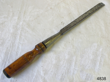 Flagstaff Hill Maritime Museum and Village
Tool - Chisel, 1940-1962
William Marples junior joined his father's joinery making business in 1821. In 1860 William's sons joined him and the firm became William Marples and sons. Over the years they acquired John Moseley & Sons a London plane maker and Thomas Ibbotson & Co a Sheffield edge tool maker. Growing to become the most prolific and best known Sheffield tool maker. Their large factory was known as the Hibernia Works. Their trademark was a shamrock that appeared on some of their tools, in 1961 they had about 400 employees. In 1962 the record Tool Company and William Ridgway acquired a fifty percent interest in the company and in 1972 the companies merged with several others to form Ridgway Tools Ltd. After 116 years at its Hibernia Works, the company was moved to Dronfield. A 1982 takeover by A G Bahco of Sweden was short-lived and in 1985 Record Ridgway returned to British ownership first as Record Marples Woodworking Tools Ltd. In 1988 then as Record Holdings PLC in 1993. In 1998 the company accepted a bid from American Tool Corporation, subsequently trading as Record Irwin. The Irwin company itself was acquired by Newell Rubbermaid in 2002 and renamed Irwin Industrial Tool Co. Both the Marples and Record names were re-branded "Irwin" However the name has since been resurrected as Irwin/Marples and applied to wood chisels and table saw blades now made at their new facility in Udine, Italy. As a footnote, William Marples was the uncle of Robert Marples and Joseph Marples, both of whom established competing tool making businesses in Sheffield. The Robert Marples firm disappeared early in the 20th century. After several changes in the company's ownership tools are now made under the Ridgway name but in China.A tool made by a company with a long family history of tool making in Sheffield England, with a member of the Marples family, Joseph Marples establishing a competing tool company which continues today to manufacture quality products for the joinery and shipwrights trades.Socket chisel with 1/2" blade."Marples & Son" stamped on bladeflagstaff hill, warrnambool, flagstaff-hill, flagstaff-hill-maritime-museum, maritime-museum, shipwreck-coast, flagstaff-hill-maritime-village, hand tool, ward chisel, woodwork chisel, marples and sons, cabinet makers tools, william marples and sons -
 Ballarat Heritage Services
Digital photograph, Brenda & Jack Ford, Diorama Hut Exterior Signage, 14 December 1993
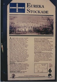
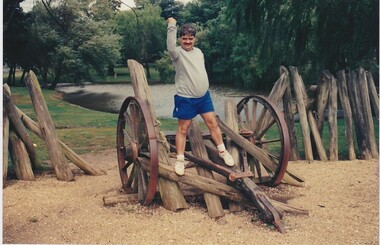
Please find 5 photographs taken by me & my wife Brenda, at Ballarat, on 14 December 1993. Unfortunately, I did not take photographs of the building that housed the exhibit, probably because I thought just how sad and pathetic the entire memorial display looked. It comprised a reconstructed slab hut and nearby a partly-rebuilt fence that represented the hastily-built Eureka Stockade. The signage that detailed the events surrounding the Eureka Stockade was affixed to the hut wall beside the entrance to the interior diorama. In the first photograph, you can see the dark, bare timber colour of the slab wood that held the signage plus (on the left side) one of the numerous holes in the slab walls. This made the display very cold and draughty in its interior. Once inside, you were confronted with an earthen, gravel and leafy floor, which became muddy, after rain, as it was on the day of our visit. The diorama was held in a glass and cement display case. with no lights on. It was dark inside the hut so the diorama was not easy to see unless you inserted a coin into a metal pay-box. Then lights would turn on and a recording of shouting and gunfire (representing the battle noise) would play. I remember the whole experience to be short and underwhelming. To get an idea of the scale of the diorama, you can see Brenda’s elbow & part torso to the left of the photograph labeled “diorama- hut exit”. Once outside the diorama’s slab hut, you could walk across to a partial representation of the stockade’s fortifications, complete with two wagon wheels. This space was also graveled to distinguish it from the rest of the green-lawn park. Finally, you walked up the hill, from the hut and outside display, to visit the old Eureka Stockade monument & cannons. This is still in existence today. Digital photographeureka stockade, sign, diorama, jack ford, brenda ford, memorial -
 Ballarat Heritage Services
Photograph - Digital photograph, Eureka Stockade Replica, 14/12/1993
Please find 5 photographs taken by me & my wife Brenda, at Ballarat, on 14 December 1993. Unfortunately, I did not take photographs of the building that housed the exhibit, probably because I thought just how sad and pathetic the entire memorial display looked. It comprised a reconstructed slab hut and nearby a partly-rebuilt fence that represented the hastily-built Eureka Stockade. The signage that detailed the events surrounding the Eureka Stockade was affixed to the hut wall beside the entrance to the interior diorama. In the first photograph, you can see the dark, bare timber colour of the slab wood that held the signage plus (on the left side) one of the numerous holes in the slab walls. This made the display very cold and draughty in its interior. Once inside, you were confronted with an earthen, gravel and leafy floor, which became muddy, after rain, as it was on the day of our visit. The diorama was held in a glass and cement display case. with no lights on. It was dark inside the hut so the diorama was not easy to see unless you inserted a coin into a metal pay-box. Then lights would turn on and a recording of shouting and gunfire (representing the battle noise) would play. I remember the whole experience to be short and underwhelming. To get an idea of the scale of the diorama, you can see Brenda’s elbow & part torso to the left of the photograph labeled “diorama- hut exit”. Once outside the diorama’s slab hut, you could walk across to a partial representation of the stockade’s fortifications, complete with two wagon wheels. This space was also graveled to distinguish it from the rest of the green-lawn park. Finally, you walked up the hill, from the hut and outside display, to visit the old Eureka Stockade monument & cannons. This is still in existence today. digital photographeureka, diorama, 1993, jack ford, brenda ford, eureka monument, memorial, eureka stockade, eureka diorama -
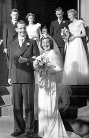 Surrey Hills Historical Society Collection
Work on paper - Photograph, Margaret Black's wedding 1st May 1948, 1948
Margaret Johnson was born and raised in the country. She came to Melbourne to attend secondary school at age eleven. She stayed with the family of her uncle, Dr Carrington, in their home / surgery still located at 174 Union Road, the Surrey Hills Medical Centre. Later, whilst waiting to commence her kindergarten training course, she met Jessie Black and they became firm friends and it was through Jessie that Margaret met Jessie’s brother and her future husband, Thorby Black. The Black family had been residents of Mont Albert for many years and Thorby was in the air force at the time. Margaret and Thorby were married at St Stephens Presbyterian Church in Surrey Hills on 1 May 1948. Her wedding dress was bought at Canns on the corner of Elizabeth Street & Flinders Lane. It was one in an exhibition held as part of a Surrey Hills Festival in the early 2000's. Like others in the exhibition, it no longer had its train and the sleeves have been shortened. Margaret recalled that after her wedding she wore it as an evening dress. Her bridesmaids’ dresses were a little unusual for the time, as they too were white and their flowers were subdued pink and blue. According to Margaret, the popular fashion was for brightly coloured dresses and bright flowers for the bridesmaids. The positioning of the garlands of flowers in their hair was also unusual. They were placed at the back so that the congregation could see them during the ceremony. Housing was in very short supply in the years following the war, so after they were married, Margaret and Thorby moved into a small flat created at Dr Carrington’s surgery. They later moved to a house built in 1926 in Black Street, Mont Albert, which continued to be Margaret’s home until her death. weddings, mrs margaret black, miss margaret johnson, mr thorby black, st stephens presbyterian church, bridal wear -
 Melbourne Legacy
Document - Speech, 24th Battalion (Gallipoli). Address by Frank Doolan (H27), 1970
A copy of an address given to a Legacy luncheon by Legatee Frank Doolan. He speaks of the 24th Battalion and their role at Gallipoli and in France. The story of the withdrawal from Gallipoli is interesting. Legatees Savige and HC Brinsmead were two of the three last lieutenants on the peninsula. Both were foundation members as was John Anderson who was also mentioned. He digresses to relate a story of an evening when he was with a 'VC mate' (assumed to be L/ Donovan Joynt) and they decided to speak to the editor of the Argus, Allan Spowers, about the newspaper's stance against the building of the Shrine of Remembrance. He related the paper published an article two days later in favour of the Shrine project and shortly after so did 'The Age'. The address also relates the return to war in 1939 and the formation of the 2/24th and it fighting in Tobruk. It was absorbed into the 9th division and later a new 2/24th was formed to wear the 'Red and White Diamond'. 'This unit consisted of younger men who had served with the CNF between the wars and included several sons of Legatees and several Junior Legatees. Our President Don, was attached for a short time.' (referring to L/ Don Simonson who was president in 1970). It went on to fight in New Guinea. Legatee Doolan's aim had been to link the 24th battalion with Legacy and suggests the book about the history of the 24th Battalion by Bob Serle was worth reading. He then introduced two other speakers, Squadron Leader Hicks, Conductor of the Royal Australian Air Force Band and Mr John Anderson of AWA. From the speakers record this event was in June 1970. The notation H27 in red pen shows that it was part of the archive project that was trying to capture the history of Legacy. Legatee Frank Doolan was part of the archive project around the 1970s.A significant account of the withdrawal from Gallipoli and other experiences of the 24th Battalion retold at a Legacy luncheon. Speakers at Legacy luncheons were from very different walks of life and the subjects spoken on were many and varied. White foolscap paper with black type x 5 pages of a speech by Legatee Frank Doolan.Handwritten H27 in red pen.history, battalion, speakers, speech, gallipoli, frank doolan, 24th battalion -
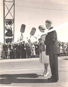 Wodonga & District Historical Society Inc
Functional object - Scissors - Princess Alexandra opens Pollard Archway, Wodonga
In 1959 Princess Alexandra of Kent visited Australia as the representative of Queen Elizabeth II for the Queensland Centenary Celebrations. Her six week visit began with her arrival in Canberra on 14th August 14 and she departed from Canberra on 26th September. Time spent in Australia included 3 weeks in Queensland. Her Royal Highness' visits to New South Wales and Victoria were comparatively brief and informal. In New South Wales she made two country visits including to Albury and a night spent at Bungowannah Park near Jindera. Her visit to Victoria began in Wodonga where she officially opened the Pollard Archway over the Causeway. She received an enthusiastic welcome as she approached the Archway accompanied by a motorcycle escort. As Princess Alexander stepped forward to take the scissors from a red plush case, her Lady-in- Waiting, Lady Moyra Hamilton, tugged at the Princess' sleeve, whispered and gave her a coin. The Princess handed the coin a halfpenny to the Wodonga Shire President, Cr J. S. Hore, saying: "I must give you this, otherwise it might be unlucky." (The halfpenny "gift" stems from an old English superstition that a "sharp" gift such as a knife or scissors must be dulled with copper or else a friendship will be lost. After cutting the ribbon and declaring the Pollard Arch, named in honour of Councillor Charles Pollard M.B.E. she was presented with a bouquet by 10-year old Leslie McLeod. Princess Alexandra led by a pipe band was driven along the Hume Highway and High Street which were lined by thousands of people including school children. After a short trip along High Street and Elgin Street to the Railway Station she departed from protocol to speak to the many children who had crossed the barricade. Princess Alexandra then boarded the Royal Train for her journey to Melbourne.This item is significant because it represents the visit to Wodonga of Princess Alexandra in 1959.A pair of scissors in a red box. The bottom of the box is lined with red cloth and the lid is lined with white silk bearing the trademark "Jewelcrest". The scissors are engraved with the maker's mark for GIESEN & FORSTHOFF/ SOLINGEN GERMANYOn top of Box. The Official Opening by Her Royal Highness Princess Alexandra of Kent 0f the Cr C F Pollard MBE Archway Wodonga 16th Sept 1959 On Scissors: GIESEN & FORSTHOFF/ SOLINGEN GERMANY TIMOR SOLINGENprincess alexandra, pollard arch -
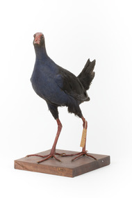 The Beechworth Burke Museum
Animal specimen - Australasian Swamphen, Trustees of the Australian Museum, 1860-1880
The Australasian swamphen is a visually striking and socially complex bird found across Oceania. It can be found in eastern Indonesia (specifically the Moluccas, Aru, and Kai Islands), Papua New Guinea, New Zealand, and Australia. As a member of the rail family (Rallidae), it belongs to the diverse order Gruiformes, which also includes cranes and other rail species. Like other rails, it possesses relatively short wings and a strong, elongated bill, both adaptations suited to its semi-aquatic wetland habitat. This swamphen is easily identified by its deep blue-purple plumage, prominent red frontal shield, and sturdy red legs. It primarily inhabits swamps, marshes, and other wet lowland areas, though its range has expanded to include pastures, roadsides, and farmland due to significant landscape modifications over the past 150 years. Unlike many wetland birds, it is highly adaptable and thrives in both natural and human-altered environments. Its diet is similarly flexible, consisting mostly of plant material such as grass stems, shoots, and leaves, but also including invertebrates and, on occasion, the young of other bird species. This specimen was misidentified as a Purple Swamphen in original catalogue records and is part of a collection of almost 200 animal specimens that were originally acquired as skins from various institutions across Australia, including the Australian Museum in Sydney and the National Museum of Victoria (known as Museums Victoria since 1983), as well as individuals such as amateur anthropologist Reynell Eveleigh Johns between 1860-1880. These skins were then mounted by members of the Burke Museum Committee and put-on display in the formal space of the Museum’s original exhibition hall where they continue to be on display. This display of taxidermy mounts initially served to instruct visitors to the Burke Museum of the natural world around them, today it serves as an insight into the collecting habits of the 19th century.This specimen is part of a significant and rare taxidermy mount collection in the Burke Museum. This collection is scientifically and culturally important for reminding us of how science continues to shape our understanding of the modern world. They demonstrate a capacity to hold evidence of how Australia’s fauna history existed in the past and are potentially important for future environmental research. This collection continues to be on display in the Museum and has become a key part to interpreting the collecting habits of the 19th century.This taxidermy specimen is of a Australasian swamphen which is mounted standing on a wooden platform and has a paper identification tag tied to its upper left leg. The specimen has dark colouring on its back and head with a purple-blue coloured neck, breast and belly. The bill is oversized and is orange/red which is the same colour as the frontal shield on the bird's face. The eyes are made from a red and black glass and the legs of this specimen are orange. The legs are elongated and the toes also long and unwebbed. 17e. / Purple Gallinule / Catalogue Page 35 / taxidermy mount, taxidermy, animalia, burke museum, beechworth, australian museum, skin, reynell eveleigh johns, bird, australian birds, swamphen, moorhen, purple bird, hen, purple swamphen, water bird -
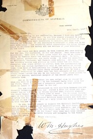 Wodonga & District Historical Society Inc
Letter - To Henry Beardmore from William Hughes, Prime Minister, 1917
Henry Beardmore represented the Green Hills Riding on Wodonga Shire Council from 1898 to 1922, including terms as President from 1900-01, 1903-4, 1908-10, 1911-12, 1914-17. He won the seat of Benambra in the Victorian Legislative Assembly at a by-election on 20th April 1917. After a few years serving simultaneously at both local and State government levels, in 1922 Mr Beardmore retired from the Wodonga Council due to his increased workload in State politics. He continuously represented the Benambra electorate as a Nationalist and United Australia Party Member for more than 15 years being returned unopposed on four occasions. Mr Beardmore was a strong advocate for country development and decentralisation. He was an Honorary Minister in 1924 and for a short time in 1929, Minister of Railways, Minister in-charge of Electrical Undertakings and Minister of Labour. He was a leading supporter of Kiewa Hydro-Electric Project and opponent of Yallourn coalfield. He remained as the Member for Benambra until his death in Wodonga on 1st August 1932. At the time this letter was written, William Hughes had been expelled from the ALP over his stance on conscription. He formed the National Labor Party which later merged with the Liberal Party to become the Nationalist Party. Henry Beardmore was a newly-elected Member of the Victorian Parliament and became a member of the Nationalist Party. Two of Henry Beardmore’s sons were on Active Service at the time and were later joined by another of their brothers. The letter aimed to gain support for Hughes at the Federal Election to be held on 5th May 1917 which his new party won with a large majority. However the Second Referendum held on conscription on 20th December 1917 at William Hughes’ instigation was defeated.This letter is significant because it was sent to an important Wodonga politician by the Prime Minister at a critical time in Australia's history.A typed letter sent to Mr Henry Beardmore by W. M. Hughes, Prime Minister 25th April 1917. It is printed on the Commonwealth of Australia letterhead. The letter has been damaged over time and has been repaired. Commonwealth of Australia letterhead Signed W. M. Hughesw. m. hughes, henry beardmore, conscription debate 1917 -
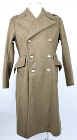 Warrnambool RSL Sub Branch
Great Coat, Bradley's Industries N.S.W, 1951
Long khaki coloured heavy coat. Thick, sharp angled collars. Right collar has a hook and eye attached in the lapel split. Collar has zig zag stitching and two plastic buttons on each the left and right sides. Each shoulder has a lapel that is fastened with a plastic button. The coat is double breasted. Three buttons on the right side, held in place by metal loops on the interior rather than stiches; mirrored on the left side. Left interior has oval shaped fabric buttoned to the interior with two brown (possibly bakelite) buttons. A larger brown button sits atop the smaller as a means of closing the jacket from the inside. There are two pockets on the front that are angled with the highest point near the centre and the lowest point near the hips. The arms, underarm and upper back section contains an inside khaki coloured lining of thinner, most likely cotton fabric. Above this there is a thin strip of fabric attached at either short end to use for hanging the coat on a hook. At the back of the coat there is a single pleat stretching from the base of the neck to the base of the coat. Approximately half way down the pleat there is a split in the fabric that is fastened with two plastic buttons. At the waist there are two fabric flaps that fasten together at the back with three buttons, also held in place with metal loops on the reverse.Label on interior back lining reads "REGIMENTAL No./NAME" Label on interior of the right "GREATCOATS. G.S. 1946 Patt/SIZE 1/HEIGHT 5'3"/CHEST 34"-36"/BRADLEY'S INDUSTRIES N.S.W./1951" Handwritten on label, "M J Davis"post war, army uniform, great coat, inter war, uniform, military uniform, wool, greatcoats, bradley's industries -
 Bendigo Historical Society Inc.
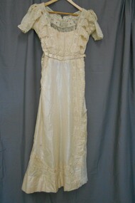
Clothing - CREAM COLOURED WEDDING DRESS, 1911
Cream coloured taffeta wedding dress. Square yoke at front with spiral bead pattern and tassels of bead across lower edge of yoke. V shaped neckline at back with yoke and tassels. Short sleeves of double layer of net embroidered with flowers. Front and back of bodice of embroidered net. Neckline lined with 10cm cotton lace. Bodice fully lined with cotton fabric. Two vertical side panels of 5cm silk lace from shoulder to waist with triangular shaped tabs (12cm) extending to side seams. 5cm silk lace with 12cm triangular tabs across the waist at back of bodice. Taffeta floor length skirt 5cm lace with 12 cm triangular tabs extends from waist on LHS down to 3cm above hemline and extends across the front in a U shape to side on RHS and then across the back of the skirt in a U shape to the LHS. Triangular insert of embroidered net (45cm at hem) on LHS, from hem to 42 cm above hem. Centre back opening from neckline(25cm) fastened with seven metal hooks and eyes. Satin fabric belt with horizontal pin rtucks fastened with two metal hooks and eyes. Fabric circular buckle (5cm diameter). Lower edge of skirt lined with cotton fabric (14 cm wide). Semi-circular cotton padding stitched under arms.costume, female, cream coloured wedding dress -
 Dandenong/Cranbourne RSL Sub Branch
Weapon - Bayonet & Scabbard
The Pattern 1907 bayonet, officially called the Sword bayonet, pattern 1907 (Mark I), was a British bayonet designed to be used with the Short Magazine Lee Enfield (SMLE) rifle. The Pattern 1907 bayonet was used by the British and Commonwealth forces throughout both the First and Second World Wars. The Pattern 1907 bayonet consisted of a one-piece steel blade and tang, with a cross guard and pommel made from wrought iron or mild steel, and a grip usually of walnut secured to the tang by two screws. The entire bayonet was 21+3⁄4 inches (550 mm) long and weighed 16+1⁄2 ounces (470 g), although the weight of production models varied from 16 to 18 ounces (450 to 510 g). The Pattern 1907 bayonet's blade was 17 inches (430 mm) long. A shallow fuller was machined into both sides of the blade, 12 inches (300 mm) long and extending to within 3 inches (76 mm) of the tip, with variations due to the judgement of individual machinists.[2][3] The Pattern 1907 bayonet was supplied with a simple leather scabbard flitted with a steel top-mount and chape, and usually carried from the belt by a simple frog. The Pattern 1907 bayonet attached to the SMLE by a boss located below the barrel on the nose of the rifle and a mortise groove on the pommel of the bayonet.[2][4] The combined length of the SMLE and Pattern 1907 bayonet was 5 feet 2 inches (1.57 GR 1907 6.......'17 Wilkinson Stamped on right side of base of blade with various symbols on the left side. Hand carved on RHS Bakelite part of handle K ? (EFX) on LHS - MB -
 Ballarat Tramway Museum
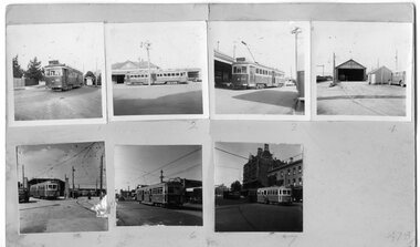
Photograph - Black & White Photograph/s, Geoff Grant, 19/06/1955 12:00:00 AM
A set of seven 2 1/4" square photographs mounted onto a sheet of manila cardboard - contact prints of each negative. Numbered from left to right, top to bottom are: 478.1 - VR Tram No. 51 running on Sandringham Route - 12/55 (Negative No. 370) - see also Reg Item 3622 for the same location and tram. 478.2 -VR tram No. 50 outside Sandringham Stn - side view 12/55 (Negative No. 371) 478.3 - VR tram No. 50 outside Sandringham Stn - 3/4 view 12/55 (Negative No. 372) - see also Reg Item 3621 for a colour print of this image. 478.4 - View of Sandringham tram depot, two door short bus on right (Negative No. 373) 478.5 - M&MTB 1033, Nth Fitzroy - AETA tour - (see Reg No. 490 and item 1620.1 for negative) 478.6 - M&MTB 1033 at East Brunswick (see Reg No. 489 also and item 1620.2 for negative) 476.7 - M&MTB 1033 at Bourke St terminus, AETA tour - 7/4/1956. (See item 1620.3 for negative) . hi res scan made and image updated 23/5/2020 for negatives where held and other images rescanned at higher resolution 12/12/2020. Image btm478i is of the overall card.trams, tramways, vr, sandringham, aeta tour , tram 50. tram 51, tram 1033 -
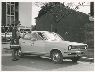 Royal District Nursing Service (now known as Bolton Clarke)
Photograph - Digital image, Barry Sutton, 10.08.1971
The RDNS Sister is about to leave to visit patients in their homes in the community to administer nursing care as advised by a Doctor. The RDNS insignia on the door of the car is a round badge with a royal blue circle around the edge with the words "Royal District Nursing Service" in white, and the centre section is in three parts ,with the upper and lower sections white, and a royal blue centre strip with the large white capital letters "RDNS".Royal District Nursing Service (RDNS) has had various modes of transport over the last 130 plus years. At first, from 1885 as Melbourne District Nursing Society (MDNS), their Trained nurses (Nurses) walked the streets and lane ways amid the slums of central Melbourne. As the Society expanded public transport was used, and bicycles were bought by the Society in 1903 and used in inner areas until 1945. During the Spanish flu epidemic, in 1919, MDNS appealed for assistance to procure Motor vehicles so the Nurses could visit an influx of cases. Through trusts, grants and donations four 'Ford T Model' cars were procured which enabled the Nurses to triple their visits. Through constant use the cars were in such a poor state two were sold in 1922 and the others later. In 1922-23 three Peugeot cars were purchased and a woman Chauffeur, 'Miss Sword', was employed who lived in the Home and was also in charge of the garage. MDNS was expanding and a Motor Auxiliary was formed in 1929 to take the Trained nurses (Sisters) to patients, and some Sisters used their own cars; even a motorcycle was used by one Sister in 1933. All these forms of transport were intermingled and in the early 1950s, and now as Melbourne District Nursing Service, seven Ford Prefect cars were bought followed by twelve Ford Anglia cars 1955. Having received Royal patronage; the now Royal District Nursing Service (RDNS) had its own fleet of Holden vehicles by the mid 1960s and the Motor Auxiliary ceased operating in 1971 as by then all staff employed were required to have a driving licence. Seat-belts had been introduced to Victoria in 1959 and District fitted them to their cars from 1962, even though they did not become compulsory until 1970. The Holden vehicles were replaced with grey Holden Torana vehicles. After several years the fleet was changed to white Toyota Corolla vehicles. The Melways Directory of maps was introduced in 1966, which was a boon to the Sisters, though it was a few years before it went beyond Seville, so a large paper map was used by the Sisters visiting patients in the areas passed Seville. By 2009 there were 598 cars in the fleet and the Sisters travelled 9 million 200,000 kilometres – this is equivalent to 12 trips to the moon and back. Black and White Photograph of a Royal District Nursing Service (RDNS) Sister about to enter one of the new light grey 2 door Holden Torana RDNS cars. The Sister, who is smiling, is wearing her uniform grey peaked hat over her long dark hair which is drawn back. She is wearing her long grey coat with the RDNS insignia on the upper sleeve and is holding the partly opened driver side door of the car with her left hand. She is holding the handle on the top of her rectangular black nursing case with her right hand. To the right, the grill and black number plate, with the white writing displaying "KXF 024", can be seen. The round RDNS insignia is on the upper centre of the car door. The car is the same width all over, has a flat bonnet which joins a sloping windscreen adjoining a flat roof which runs along and joins a short back window running down to a boot. A black tyred wheel can be seen under wheel arches at the front and near the rear of the vehicle. In the background to the left is a mid size bare tree; behind this portions of several parked cars and behind them a multi storey building with the Written words "Rioby House". To its right and directly behind the car is a mid size bare tree and behind that the end view of a brick building with a hip roof. Barry Sutton Photographer. Quote KL 52rdns transport, rdns uniform, royal district nursing service, rdns -
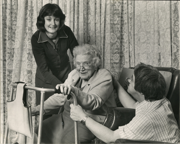 Royal District Nursing Service (now known as Bolton Clarke)
Photograph - Photograph, black and white, c.1980
An RDNS Sister had previously visited Mrs. Crook in her home and assessed the nursing care she required. Following the Sister's instructions, the Home Health Aide in this photograph, Robin Brown, is assisting Mrs. Crook from her lounge chair onto her walking frame. Mrs. Crook's son, Robert is also assisting his mother. Home Health Aides were employed and trained by Royal District Nursing Service (RDNS) from 1980. They wore a RDNS royal blue uniform, which has a white trim and RDNS badge applied to the left hand side, and a dark blue cardigan. In 1980, a Home Health Aide ‘Pilot study’, funded by the Federal Government, the Brotherhood of St. Laurence and RDNS, with the program written and taught by RDNS Principal Nurse Educator. Pat (Paddy) Rowley, was evaluated as successful. Following this Pilot study, Home Health Aides were employed by RDNS, and after instruction in the RDNS Education department, joined RDNS Centres and worked under the supervision of the RDNS Trained nurses (Sisters). The Sister assessed each patient, then introduced and supervised the Health Aide in the patient procedure required. The Sister wrote out clear, concise procedural instructions on a work card which the Health Aide followed each visit. If the Health Aide noticed any change in the patient’s condition, this was reported immediately and the Sister visited. The Sister made routine visits to the patient for review at least monthly. On the left of this black and white photograph is Royal District Nursing Service, Home Health Aide, Robin Brown, who has dark shoulder length hair and is wearing a dark cardigan over her dark coloured uniform which has white piping at the edge. To her right is Mrs. Crook who is sitting froward in her lounge chair. A walking frame, which has a material bag hanging from the front bar, is in front of her. Robin Brown has her left hand on Mrs Crook's back and her right hand under her arm. Mrs. Crook has curly white hair; is wearing glasses which are resting partly down her nose, and is wearing a light coloured cardigan over her dark dress. Part of a necklace of pearls can be seen hanging over her dress. She is smiling and looking at the camera. She has her right hand on the upper part of the right wing of the walking frame and her left hand is on the top hand grip section on the left wing of the frame. To her right, her son, Robert, who is squatted down by the chair, has short dark hair and is wearing a checked shirt. He is holding the left wing of the walking frame with his left hand and his right arm is extended with his hand on his mother's back. Closed floral curtains are seen in the rear of the photograph.Photographer's stamprdns, royal district nursing service, home health aide, home health aide uniform, patient care, mrs crook, mr robert crook, home health aide robin brown -
 Royal District Nursing Service (now known as Bolton Clarke)
Photograph - Photograph, black and white, Barry Sutton, 22.06.1977
Royal District Nursing Service (RDNS) Sisters worked from this, their rented Collingwood Centre at 98 Charles Street, Collingwood, which opened in 1977. The Sisters left each morning taking any sterilized equipment needed with them to carry out their nursing visits in a specific area (district), They returned at the end of the day to write up their patients nursing histories, clean and reset any equipment used ready for re-sterilization, and contact other medical and community personal as necessary. From its inception as Melbourne District Nursing Society (MDNS), in 1885, their Trained nurses (Nurses) worked in specific areas, 'districts'. The first Nurse worked east and west, between Victoria Parade and Flinders Street and, north and south, between Spencer Street and Spring Street. When a second Nurse was employed they divided this area at Elizabeth Street so each Nurse could attend to patients in the same area giving continuity of care. Gradually over the years, Melbourne District Nursing Service (MDNS), later known as Royal District Nursing Service (RDNS) from 1966 when they received Royal patronage, opened Centres throughout the Melbourne Metropolitan area and outer suburbs with Heidelberg Centre opening in 1971. Their Trained nurses (Sisters) left from these Centres each morning to carry out their nursing visits in a specific area (district), taking any sterilized equipment needed with them. They returned at the end of the day to write up their patients nursing histories, clean and reset any equipment used ready for sterilization, and contact other medical and community personal as necessary. Through its expansion quality of care was not lost, the RDNS nursing staff gave best practice care in many fields of nursing and to people of many cultures with their patients ranging in age from babes, children, adults to the elderly. Some of the care provided was – Post-Natal care, Diabetic Care, Wound Care, Giving of injections and medications, Catheterizations on children and adults, Stoma care, Dementia care, Palliative Care, General care, Rehabilitation, Spinal care, Cystic Fibrosis care, Haemo-Oncology care, Home Enteral Feeding care, and IV therapy at home. Assisting with rehabilitation with an aim towards independence remained at the forefront of the Sister’s minds. All care included giving advice and support to the patient and their Carers. Black and white photograph showing the front facade of the Royal District Nursing Service (RDNS), Collingwood Centre. It is a Victorian style, single story, light coloured painted concrete faced building built around the 1870s. To its left is the front wooden door with a small central glass section in the upper center, and a wire door in front of this. To its right is an Electricity Department meter attached to the wall, and under this a large "98" and to its right, and a little lower is an attached rectangular white sign, with black capital letters, saying "Royal District Nursing Service" and below this in smaller letters "Collingwood". To the right sits a long sash window with dark frame. At either end of the building white concrete face extensions, with embellishments, support a corrugated iron straight veranda roof, with wrought iron embellishment attached to its outer edge. This sits above the window and door and runs along the building protecting the small porch. Above this, along the building, is deep decoration, including a row of concrete balusters and above and central is a concave shell shaped structure. A short dark metal spiked fence runs along the edge of the narrow garden bed. In the foreground the footpath and part of a road can be seen. A small bare tree can be seen on the left hand side of the building and a small bush on the right hand side.Photographer stamp. Quote No. DO 66royal district nursing service, rdns, rdns centre -
 Bendigo Historical Society Inc.
Document - LETTER DESCRIBING BENDIGO'S GRANDEST BUILDINGS
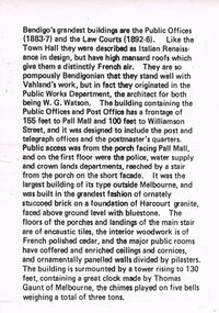
Bendigo's Grandest Buildings are the Public Offices (1883-7) and the Law Courts (1892-6). Like the Town Hall they were described as Italian Renaissance in Design, but have high mansard roofs which give them a distinctly French air. They are so pompously Bendigonian that they stand well with Vahland's work, but in fact they originated in the Public Works Department, the architect for both being W.G. Watson. The building containing the Public Offices and Post Office has a frontage of 155 feet to Pall Mall and 100 feet to Williamson Street, and it was designed to include the post and telegraph offices and the postmaster's quarters. Public access was from the porch facing Pall Mall, and on the first floor were the police, water supply and crown lands departments, reached by a stair from the porch on the short façade. It was the largest building of its type outside of Melbourne, and was built in the grandest fashion of ornately stuccoed brick on a foundation of Harcourt granite, faced above ground level with bluestone. The floors of the porches and landings of the main stair are of encaustic tiles, the interior woodwork is of French polished cedar, and the major public rooms have coffered and enriched ceilings and cornices, and ornamentally panelled walls divided by pilasters. The building is surmounted by a tower rising to 130 feet, containing a great clock made by Thomas Gaunt of Melbourne, the chimes played on five bells weighing a total of three tons.bendigo, buildings, state offices -
 University of Melbourne, Burnley Campus Archives
Photograph - Black and white photographs, A.W. Jessep, Grafting and Cutting Display, Unknown
Black and white photographs of various sizes pasted on cardboard for display purposes. Some annotated. Labelled: (1) Rose with 4 pieces cut off it. (2)"Citrus rootstock in nursery ready for budding." (3) "Feb. Left. Healthy budstick of current season's growth. Right. Prepared budstick, foliage and undeveloped buds removed, short section of leaf-stick reatined." (4) Same as (3). (5)"Harvest scions while dormant and store in moist, well-drained soil." (6) "Whip-tongue graft after one season of growth." (7) "Graft after one season of growth." (8) "Mastic applied to keep air and moisture from the cut surfaces." (9) "Graft tied to prevent movement." (10) "Young camellia-struck cutting." (11) Cutting beside pot. (12) "Feb. Same pot camellia struck." (13) Clump of dug-up perennials. (14) Divided piece. (15) Trimmed. (16) "April. Seedling Polyanthus." (17) Cuttings. (18) Clump of rooted cuttings. (19) Trimming rooted cutting. (20) Clump of Begonia. (21) Dividing Begonia. (22) Begonia leaf cut into pieces. (23) Rooted cuttings from leaf. (24) Putting leaf pieces in pot. (25) Pot of rooted cuttings. (26) Lupin seedlings emerging. (27) Lupin seedlings. (28) Clump of roots? From A. W. Jessep.roses, nursery, budstick, grafting, growth, camellia, polyanthus, cutting, trimming, begonia, dividing, a. w. jessep, citrus rootstock, scions, whip-tongue graft, perennials, lupin seedlings, teaching -
 Royal Australian and New Zealand College of Obstetricians & Gynaecologists (RANZCOG)
Print - hand coloured aquatint engraving, James Malton (1761 -1803), Lying in Hospital, 1791
This is an image of the Rotunda Hospital in Dublin. Established as the Dublin Lying-In Hospital in 1745, it moved to its current location in 1757 and remains there to this day. This image was first published in Malton's 'A Picturesque and Descriptive view of the City of Dublin' in 1791.A colour engraving of a white building with a red roof. A tower, topped by a dome, rises above the middle of the building. There are four decorative columns on the front of the building, and the entrance to the building is surrounded by a metal fence. There are various figures in the foreground of the image. On the left, there is a well dressed family group consisting of three adults and a child. At left of centre, a figure is riding a horse, which is being preceded by a dog. At centre, in the middle background, one tall and one short figure stand next to the metal fence surrounding the building and are peering inside. At right of centre, a figure is driving a two horse buggy. On the far right, the shadowed figure of a beggar is holding out their cap. There is a smaller building to the left hand side of the featured building, and additional buildings are visible in the right side background. Clouds are visible behind the buildings. Text below image reads 'Lying in Hospital'. The print is mounted and framed in a black wooden frame with gold trim. A display label for this print is attached to the back of the frame. Handwritten inscriptions on the back of the frame of the artwork read 'Rotunda Lying in Hospital/Dublin // 19th British Congress RCOG 1971' and 'Original engraving/James Malton. London,/December 1795.' There is a sticker attached to the bottom right of the back of the frame featuring a printed image of a stork in read and the text 'FRIENDS OF THE ROTUNDA HOSPITAL'. There are two hooks and a wire attached to the back of the frame for hanging.