Showing 11585 items matching " map"
-
 Melbourne Tram Museum
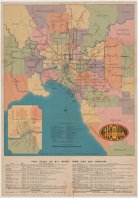
Ephemera - Map - Timetable, Melbourne & Metropolitan Tramways Board (MMTB), "Map and timetable of Melbourne Tram and Bus Services", March 1952
Map provided information about Melbourne's tramway network in 1952. At base of map - timetable of all night trams and bus services. On rear index to routes, 1st and last services, time of Sunday am services, Latrobe St. services and photo of Wattle Park. The conversion of Bourke St to electric trams marked up. Copy 1 - has been marked for hypothetical extensions in blue pencil mainly in the northern and western suburbs. In particular note the Ballarat Road and South Road markings. Copy 2 - has been marked up for newer route numbers, following the opening of the Bourke St services and additional route numbers on the Essendon Depot lines. Demonstrates the provision of information about Melbourne tram services.Fold out map (10 sections - 2 high x 5 wide), coloured of Melbourne's Tram and Bus routes, route numbers, rail lines, municipalities boundaries and location of major places of interest. melbourne, tram and bus services, mmtb, buses, trams, routes, timetables, all night services -
 Ballarat Heritage Services
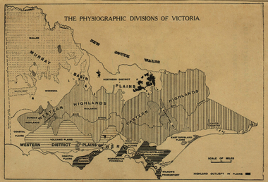
Map, Physiographic Divisions of Victoria, c1940, c1940
Physiographic map of Victoriavictoria, map, physiography -
 National Vietnam Veterans Museum (NVVM)
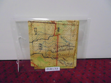
Map
A laminated coloured military map showing topography of areas around Nui Dat with divisional sections hand drawn in black.map, nui dat, mcphail collection -
 Falls Creek Historical Society
Map - Falls Creek Alpine Resort Map
Julian Newton-Brown arrived at Falls Creek in 1957. He had studied Pharmacy at Melbourne University. After developing a love for the mountains, Julian moved to Mt. Beauty and then Falls Creek. He worked for the SEC in the test laboratory at Rocky Valley reading weather instruments. By working several jobs, Julian was able to build a small lodge of 10 beds named “Arundel”, located at 18 Slalom Street, Falls Creek. The lodge is now the “Elk at Falls”. Arundel prospered and Julian extended it to include 32 beds and changed its name to "Julian’s” in 1961. When alcohol restrictions were eased in Falls Creek, Julian built a night club which he called “Big Julian’s” and later “THE MAN”. When Julian and his wife Beth retired and left Falls Creek, their son took over running the lodge. An active community man, Julian was a member of the Falls Creek Chamber of Commerce, a member of the SES, a stakeholder in Falls Creek, an author and a documentary maker. Julian Newton-Brown died in May 2020.This map is significant because it contains an image of Falls Creek Alpine Resort.A black and white map of Falls Creek Alpine Resort Map featuring a photo taken by Julian Newton Brown. A numbered legend is included at the bottom right corner.dawn ski club, accommodation falls creek, lodges falls creek, tom mitchell -
 Moorabbin Air Museum
Map (item) - Aloha Airlines - map of the islands of Hawaii, Aloha Airlines - map of the islands of Hawaii circa 1955
-
 Queenscliffe Maritime Museum
Map - Port Phillip Bay at Queenscliffe 1936, Map of Queenscliffe Parks & Foreshore, unknown
Queenscliffe life c1936Map of Queenscliffe in c1936copy of an L-shaped map of 1936 Queenscliffe foreshoreReverse - " nil ".historical references -
Stawell Historical Society Inc
Map, Section of Map, Stawell including Stawell Rifle Range, 1969
Section of Map, Stawell including Stawell Rifle Rangestawell -
University of Melbourne, Burnley Campus Archives
Map (item) - Geological map, Geological map of Melbourne & suburbs. Issued by the Department of Mines, Victoria, 1937
-
Tatura Irrigation & Wartime Camps Museum
Map - Plaster Cast, Map of Australia, 1940's
Made by POW at Dhurringile Internment CampMap of Australia, plaster cast, bell shaped, in which is a copper penny and a rosella atop Cape York. Dated 1940 words "Tatura Vic" below map of Australia1940 Tatura- Dhurringile intern Campplaster caste, map of australia, layton family, dhurringile camp, tatura, camp, ornament, plaster -
Clunes Museum
Map, DJA DJA WARRUNG RECOGNITION AND SETTLEMENT AGREEMENT AREA, 2013
MAP DJA DJA WURRUNG RECOGNITION AND SETTLEMENT AGREEMENT AREACOLOUR PRINTED MAP LAMINATED. SHOWING THE DJA DJA WURRUNG RECOGNITION AND SETTLEMENT AGREEMENT AREA SUBJECT TO RECOGNITION AND SETTMENT AGREEMENT 2013dja dja wurrung, map of recognition area -
 Ballarat Heritage Services
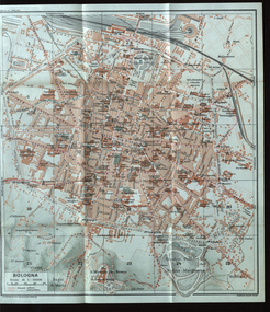
Map, Bologna, 1924, 1924
Map of Bologna, Italy in 1924italy, bologna, map -
 Ballarat Heritage Services
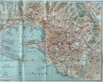
Map, Genoa, 1924, 1924
Map of Genoa, Italy in 1924italy, map, genoa -
 Ballarat Heritage Services
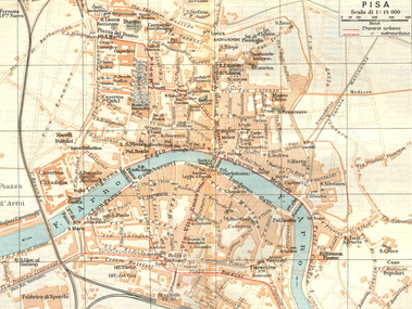
Map, Pisa, Italy, 1924, 1924
Map of Pisa, Italy in 1924italy, map, pisa -
 Ballarat Heritage Services
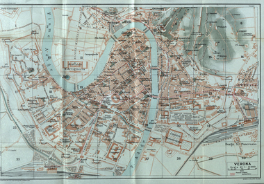
Map, Verona, 1924, 1924
Map of Verona, Italy in 1924italy, map, verona -
Stawell Historical Society Inc
Map, Plan Shewing Auriferous Deposits and Reefs (Map of Water Races), c1878
Plan Shewing Auriferous Deposits and Reefs (Map of Water Races)stawell, water -
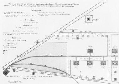 Ringwood and District Historical Society
Photograph, Land sale brochure map of Ringwood's early main central area around Mount Dandenong Road - c.1880s
Catalogue card reads, 'Map of Ringwood East'. -
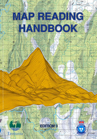 Victorian Aboriginal Corporation for Languages
Book, Tasmania State Emergency Service, Map reading handbook, 1997
maps, b&w photographs, charts, diagramsmaps reading, aerial photographic maps, global positioning systems, topographical maps, compasses -
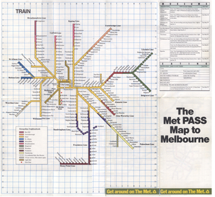 Melbourne Tram Museum
Map, The Met, "The Met PASS Map to Melbourne", c1988/90
Folded Map of Melbourne Rail and Tram lines, titled "The Met PASS Map to Melbourne" Tram Map - probably soon after conversion of the St Kilda and Port Melbourne lines to Light Rail, though these are not shown. Opened November 1987. Rail Map - shows Route 96 north section as Light Rail, co-ordinated bus routes, and the Altona line as going to Werribee. This route was opened in 1985. Date of Map c1988/1990. Has details of Museums, Art Galleries, Shopping, Gardens and Sports Arenas. See also Reg Item 379 for a similar item.trams, tramways, the met, melbourne, maps, tourist tickets -
 Buninyong Visitor Information Centre
Map, Early Squatters Stations 1837-1838
The map shows rivers and pastoral holdings from 1837 to 1838. Stations occupied around Geelong in 1837 are shown in red and those occupied in 1838 are shown in black. Reproduction of a coloured map shows pastoral stations around the Geelong area from 1837-1940. pastoralism, stations, farming, settlement, squatters -
 Greensborough Historical Society
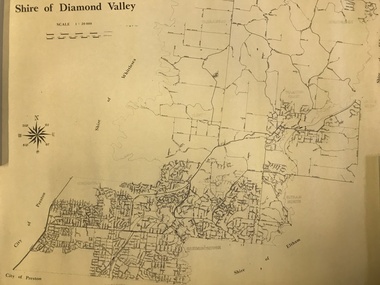
Map, Shire of Diamond Valley, 1964-1994
Map of the former Shire of Diamond Valley, 1964-1994, showing the local government area from Greensborough to Hurstbridge.Map on yellowed paper.shire of diamond valley, greensborough, hurstbridge -
 Greensborough Historical Society
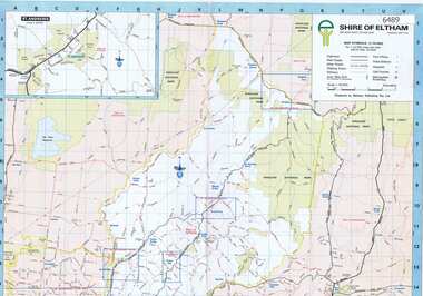
Map, Shire of Eltham, 1990c
1:20000 map of Shire of Eltham, with enlargements of a number of areas.Colour map, printed both sides.shire of eltham, eltham -
 Ballarat Tramway Museum
Map, Electric Supply Co. of Vic (ESCo), Ballarat Electoral Map - ESCo, 1900
Document prepared by the Electric Supply Co of Victoria, as part of an order under the Electric Light and Power Act 1896, section 5 of order No. 17 granted to company. Dated 19/2/1901 and signed by the Postmaster-General. Shows the order area being parts of the City of Ballaarat, Sebastopol and Ballarat East. Shows the street names, boundaries, principal power line routes, land reserves, parks, mine locations, railways and Lake Wendouree. Signed by R L Williams Town Clerk City of Ballarat, J R Hall for the Borough of Sebastopol, and John Gent for the Town of Ballarat EastYields information about the power supply to the Ballarat area.Cloth backed paper map, coloured and marked up as exhibit 17.Notes in ink including the signature of Benjamin Deakin 24/9/00 and certified by the three involved municipal Town Clerks.ballarat power supply, esco, electric supply co of victoria, city of ballaarat, east ballarat, sebastopol, orders, power lines, power supply -
 Federation University Historical Collection
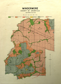
Map, Windermere, County of Grenville
Coloured geological map of Windermere, County of Grenville. Scale is 40 chains to 1 inchwindermere, grenville, krause, plan, map -
 Melbourne Tram Museum
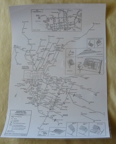
Poster, P. Sohns, "Melbourne Tram Track map (June 2006)", 2006
Poster - titled "Melbourne Tram Track map (June 2006)", line drawing on white paper, showing a detailed track map of junctions, depots, cross overs, route numbers, Preston Workshop, track out of service but overhead still in place, routes under construction of planning. Prepared by P. Sohns with Research by H. Waldron. Dated 8/4/2006. Has a detailed inserted of the city area. One unlaminated and one laminated copy held.trams, tramways, melbourne, map, tramways, depots, workshops, tram routes -
Clunes Museum
Map, G.J. WILLIAMS, SHIRE OF TALBOT & CLUNES, UNKNOWN
BLACK AND WHITE HAND DRAWN MAP. SHIRE OF TALBOT & CLUNES. SHOWING SEALED ROADS, GRAVEL ROADS AND PARTLY FORMED ROADS. SCALE 1:100,000map, clunes, talbot -
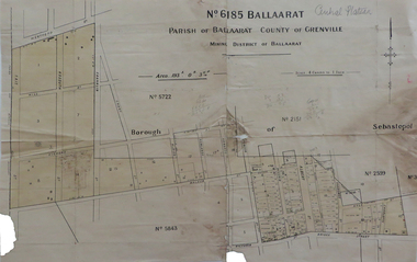 Federation University Historical Collection
Map, No 6185 Ballaarat Parish of Ballaarat County of Grenville, not dated
Printed map with pencil inscriptionsmap, parish of ballaarat, grenville county, sebastopol, central company engine house, wesleyan reserve, victoria street, yarrowee street, charlotte st, kyle street -
 Warrnambool and District Historical Society Inc.
Map - City of Warrnambool Freehold and Managed Crown Land, City of Warrnambool Council, 14th April 1994
This map was drawn up by the City of Warrnambool Council staff to provide information on the land in Warrnambool that was owned or managed by the Council.This map is of considerable importance as it gives information in map form of the Warrnambool land that is owned (freehold) by the City of Warrnambool and the land that is managed Crown land. This is of interest to researchers and those seeking information on specific areas of land in Warrnambool.This map has digital mapping. The map has a white background with black and white mapping details of Warrnambool. It has the City of Warrnambool seal. Scale of map: 1:7500warrnambool city council, warrnambool -
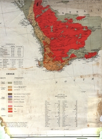 Federation University Historical Collection
Map, Geological Map (Southern Western Australia), post 1880
Includes the routes of exploration, including E. Giles, A. W. Howitt, Burke & Wills, Hume & Hovell, Major Mitchell, A Forrest.A section of a map showing geology and routes of exploration. Southern Western Australia only geology, exploration, railways, electric telegraphs -
Stawell Historical Society Inc
Map, Easton Johnstone, Map of Stawell Surveyed by Easton Johnstone 1872, 1872
Victoria Co Crushing Machine. St Georges Co Crushing machine. Wimmera Co Crushing Machine. Government Reservoir and Drainage. Sloan Street, Skene Street Mines. old Mine WorkingsA2 map of Stawell Reefs Area. Showing Crushing Machines & Title InfoSurveyed by Easton Johnstone Contract Surveyor. Photo-Lithographed at the Department of Lands & Survey. Melbourne By J Noone 9th May 1872mining -
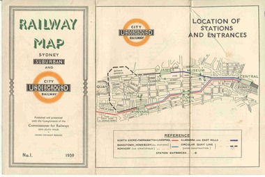 Ballarat Tramway Museum
Map, NSWGR, "Railway Map of Sydney Suburban and Underground" - 1939, 1939
Light card or Heavy paper. Colour map showing location of Sydney stations and entrances and where the trains ran. Issued as No.1. Title "Railway Map of Sydney Suburban and Underground" - 1939. Handle with care - both copies.trams, tramways, sydney, railway map, suburban and underground, trams