Showing 492 items matching " planning scheme."
-
 Kew Historical Society Inc
Plaque, Kew City Hall : Opened by The Hon H.E. Bolte M.L.A. Premier of Victoria 23rd April 1960 : Cr H.H. Ferguson J.P. Mayor, 1960
The Municipality of Kew was proclaimed on 19 December 1860, then upgraded to a Borough (1863), a Town (1910) and finally a City (1921). From 1865, its offices were based in the former Athenaeum Hall in Walpole Street, which, although extended in 1883, inevitably became inadequate. Plans for a new purpose-built Town Hall were first mooted in the late 1880s, but fell prey to six subsequent decades of debate. During that time, many sites were considered and rejected, and several schemes prepared. Finally, in 1945, it was resolved to build a new civic centre as a war memorial. The council acquired Southesk, a mansion on the south-west corner of Cotham Road and Charles Street – first mooted as a possible Town Hall site two decades earlier – and plans for a civic precinct were drawn up by John Scarborough. The project stalled until 1957, when a Town Hall Committee was formed and a new architect appointed: Harold Bartlett of Leith & Bartlett. He also proposed an entire civic precinct, of which a large public hall would constitute Stage One. Designed to accommodate almost any public or official function, the space had had a small stage at one end for intimate theatrical productions, a larger stage at the other (with operable sunken orchestra pit) for musical performances, plus the most up-to-date equipment for live TV transmission. The building, befitting its original intent as a war memorial, was also to include a sculpted monument, for which a separate design competition was held. First prize went to George H Allen (1900-1972), long-time head of the Sculpture Department at RMIT and a former war artist himself (the only one, in fact, to have worked in the medium of sculpture). At the time of the Kew project, Allen was best known for his Cenotaph at the Shrine of Remembrance (1955) and a controversial abstract sculpture at Hume House in William Street (1957). Tenders for the new hall were called and the contract (worth £104,986) was awarded to H F Yuncken. The foundation stone was laid by the Mayor, Cr F C O'Brien, on 1 June 1959. Completion (initially scheduled for October) was delayed by the unavailability of certain materials; it was barely finished in time for the official opening (by Premier Henry Bolte) on 23 April 1960. The war memorial was unveiled two days later (Anzac Day) by Bolte's deputy, the Hon A G Rylah. Fittingly, that year also marked Kew's municipal centenary, and many celebratory events were held in and around the new civic centre in December, including a special council meeting (attended by the Prime Minister), a tree planting ceremony and a youth ball. Source: Survey of Built Heritage in Victoria: Stage Two (Built Heritage Pty Ltd., 2010)Plaque commemorating the opening of a new town hall in KewMetal plaque recording the official opening of the Kew City Hall, 23rd April 1960. This plaque was given to the Kew Historical Society in 1991 by the former City of Kew.Kew City Hall / Opened by / The Hon. H.E. Bolte M.L.A. / Premier of Victoria / 23rd April 1960 / Cr. H.G. Ferguson J.P. - Mayor.kew city hall, foundation stones - kew (vic), sir henry bolte, local government -- kew (vic.) -
 Kew Historical Society Inc
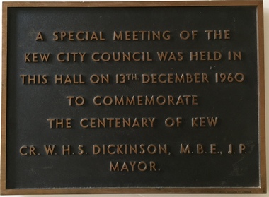
Plaque, A Special Meeting of the Kew City Council Was Held in This Hall on 13th December 1960 to Commemorate the Centenary of Kew : Cr. W.H.S. Dickinson M.B.E., J.P. Mayor, 1960
The Municipality of Kew was proclaimed on 19 December 1860, then upgraded to a Borough (1863), a Town (1910) and finally a City (1921). From 1865, its offices were based in the former Athenaeum Hall in Walpole Street, which, although extended in 1883, inevitably became inadequate. Plans for a new purpose-built Town Hall were first mooted in the late 1880s, but fell prey to six subsequent decades of debate. During that time, many sites were considered and rejected, and several schemes prepared. Finally, in 1945, it was resolved to build a new civic centre as a war memorial. The council acquired Southesk, a mansion on the south-west corner of Cotham Road and Charles Street – first mooted as a possible Town Hall site two decades earlier – and plans for a civic precinct were drawn up by John Scarborough. The project stalled until 1957, when a Town Hall Committee was formed and a new architect appointed: Harold Bartlett of Leith & Bartlett. He also proposed an entire civic precinct, of which a large public hall would constitute Stage One. Designed to accommodate almost any public or official function, the space had had a small stage at one end for intimate theatrical productions, a larger stage at the other (with operable sunken orchestra pit) for musical performances, plus the most up-to-date equipment for live TV transmission. The building, befitting its original intent as a war memorial, was also to include a sculpted monument, for which a separate design competition was held. First prize went to George H Allen (1900-1972), long-time head of the Sculpture Department at RMIT and a former war artist himself (the only one, in fact, to have worked in the medium of sculpture). At the time of the Kew project, Allen was best known for his Cenotaph at the Shrine of Remembrance (1955) and a controversial abstract sculpture at Hume House in William Street (1957). Tenders for the new hall were called and the contract (worth £104,986) was awarded to H F Yuncken. The foundation stone was laid by the Mayor, Cr F C O'Brien, on 1 June 1959. Completion (initially scheduled for October) was delayed by the unavailability of certain materials; it was barely finished in time for the official opening (by Premier Henry Bolte) on 23 April 1960. The war memorial was unveiled two days later (Anzac Day) by Bolte's deputy, the Hon A G Rylah. Fittingly, that year also marked Kew's municipal centenary, and many celebratory events were held in and around the new civic centre in December, including a special council meeting (attended by the Prime Minister), a tree planting ceremony and a youth ball. Source: Survey of Built Heritage in Victoria: Stage Two (Built Heritage Pty Ltd., 2010)Historically significant commemorative plaqueMetal plaque relating to special Council meeting to mark centenary of Kew, 13th December 1960. This plaque was given to the Kew Historical Society in 1991 by the former City of Kew.A Special Meeting Of The / Kew City Council Was Held In / This Hall On 13th December 1960 / To Commemorate / The Centenary of Kew / Cr. W.H.S. Dickinson, M.B.E., J.P., / Mayorkew city hall, foundation stones - kew (vic), cr. w.h.s. dickinson, local government -- kew (vic.) -
 Kew Historical Society Inc
Book, Plan of General Development, Melbourne : Report of the Metropolitan Town Planning Commission
... pocket) This was a planning scheme to prevent 'misuse' of land ...The 1929 report of the Metropolitan Town Planning Commission covering Melbourne and its suburbs. Includes photographs and 15 folding maps (some in rear pocket) This was a planning scheme to prevent 'misuse' of land and protect property values. It highlighted traffic congestion, the distribution of recreational open space and haphazard intermingling of land uses. The plan identified a number of problems, such as the congestion at St Kilda Junction, that were not addressed until decades later. The plan also recognised the value of Melbourne's waterways as an open space network.xii, 308 p., [25] leaves of plates (24 folded) : ill., maps (some col.), ports., plans ; 34 cm. CONTENTS Part 1 Surveys and studies Part II Communications Part III The execution of improvement schemes - a programme of urgent works Part IV Zoning Part V Public Recreation Part VI Public Utilities Part VII Housing and Land Subdivision Part VIII Civic Art and Amenities Part IX Miscellaneous Part X Legislation Part XI Conclusionnon-fictionThe 1929 report of the Metropolitan Town Planning Commission covering Melbourne and its suburbs. Includes photographs and 15 folding maps (some in rear pocket) This was a planning scheme to prevent 'misuse' of land and protect property values. It highlighted traffic congestion, the distribution of recreational open space and haphazard intermingling of land uses. The plan identified a number of problems, such as the congestion at St Kilda Junction, that were not addressed until decades later. The plan also recognised the value of Melbourne's waterways as an open space network.city planning -- victoria. -- maps, city planning -- victoria -- melbourne, city planning -- victoria, civic improvement -- victoria -- melbourne, melbourne -- (vic.), cartography -
 Kew Historical Society Inc
Journal, Kewriosity : September 1990
Committee changes give new powers / p1/2. City's success seen in strategic planning / p1. Dates for September / p2. Sharing responsibility for literacy / p2. Bush dance / p2. Commentary / Cr Daryl Oldaker p3. Mayoral team profile / p3. Information day on women's health / p4. Beaumont soiree / p4. St George's supports World Vision / p4. Lone ride for cancer research [Steven Duthie] / p4. Fax link for cabs / p5. Parking permit fees / p5. Anzac legend / p5. "Sharps' scheme for Kew / p5. Council supports call for TV translator / p5. Kinder enrolments up / p6. Older adults meed leisure opportunities, report finds / p6. Images on Kew [Richard Birmingham at Gretz Gallery] / p6. Birthing alternative [St George's Hospital] / p6. Health strategy for young people / p7. Seniors podiatry sessions / p7. Did you attend Kew Primary School? / p7. Letters to the editor / p8. In the twinkling twilight [Kew Festival] / p8. Traffic management update / p8. Cricket recruiting drive / p8.Kewriosity was a local newsletter combining Kew Council and community news. It was published between November 1983 and June 1994, replacing an earlier Kewriosity [broad] Sheet (1979-84). In producing Kewriosity, Council aimed to provide a range of interesting and informative articles covering its deliberations and decision making, together with items of general interest and importance to the Kew community and information not generally available through daily media outlets.non-fictionCommittee changes give new powers / p1/2. City's success seen in strategic planning / p1. Dates for September / p2. Sharing responsibility for literacy / p2. Bush dance / p2. Commentary / Cr Daryl Oldaker p3. Mayoral team profile / p3. Information day on women's health / p4. Beaumont soiree / p4. St George's supports World Vision / p4. Lone ride for cancer research [Steven Duthie] / p4. Fax link for cabs / p5. Parking permit fees / p5. Anzac legend / p5. "Sharps' scheme for Kew / p5. Council supports call for TV translator / p5. Kinder enrolments up / p6. Older adults meed leisure opportunities, report finds / p6. Images on Kew [Richard Birmingham at Gretz Gallery] / p6. Birthing alternative [St George's Hospital] / p6. Health strategy for young people / p7. Seniors podiatry sessions / p7. Did you attend Kew Primary School? / p7. Letters to the editor / p8. In the twinkling twilight [Kew Festival] / p8. Traffic management update / p8. Cricket recruiting drive / p8.publications -- city of kew (vic.), kewriosity, council newsletters, community newsletters -
Kew Historical Society Inc
Journal, Kewriosity : August 1990
... and a chat [ Kew Community House] / p5. Govt amends Kew Planning ...Council assistance available to maintain homes / p1. Rates reminder / p1. No elections / p1. Dates for August / p2. Breast information session / p2. One act plays [Track Players] / p2. Strategies for success / p2. Rotary changeover [Kew Rotary Club] / p2. Kew's kindergartens to open doors / p3. Budget to take care of basics / p3. Urban women have a taste for country life [Kew/Balwyn Country Women's Association CWA] / p3. Your community bus needs you / p3. Recruiting drive [Meals on Wheels] / p3. Notices / p4. Major donation to St George's [Hospital] [Kew Rotary Club] / p4. Carey's new head / p4. Library corner / p4. Update on traffic / p4. Family day care / p5. Centenary celebrations for Kew East [Primary School] / p5. Courses, coffee and a chat [ Kew Community House] / p5. Govt amends Kew Planning Scheme [Willsmere] / p5. Backyard burning banned / p5. Kew Community House [courses] / p6. Clean up for Studley Park [Boroondara Bushwalkers] / p6. Council re-assesses proposal [skateboard bowl at Victoria Park] / p6. Meetings promote care giver act / p7. Council seeks community reps / p7. Kew Primary promotes its assets / p7. Recipe for success [Children's International Summer Villages] / p8. Special paper collection / p8. "Kew is for Living" [Kew Festival] / p8.Kewriosity was a local newsletter combining Kew Council and community news. It was published between November 1983 and June 1994, replacing an earlier Kewriosity [broad] Sheet (1979-84). In producing Kewriosity, Council aimed to provide a range of interesting and informative articles covering its deliberations and decision making, together with items of general interest and importance to the Kew community and information not generally available through daily media outlets.non-fictionCouncil assistance available to maintain homes / p1. Rates reminder / p1. No elections / p1. Dates for August / p2. Breast information session / p2. One act plays [Track Players] / p2. Strategies for success / p2. Rotary changeover [Kew Rotary Club] / p2. Kew's kindergartens to open doors / p3. Budget to take care of basics / p3. Urban women have a taste for country life [Kew/Balwyn Country Women's Association CWA] / p3. Your community bus needs you / p3. Recruiting drive [Meals on Wheels] / p3. Notices / p4. Major donation to St George's [Hospital] [Kew Rotary Club] / p4. Carey's new head / p4. Library corner / p4. Update on traffic / p4. Family day care / p5. Centenary celebrations for Kew East [Primary School] / p5. Courses, coffee and a chat [ Kew Community House] / p5. Govt amends Kew Planning Scheme [Willsmere] / p5. Backyard burning banned / p5. Kew Community House [courses] / p6. Clean up for Studley Park [Boroondara Bushwalkers] / p6. Council re-assesses proposal [skateboard bowl at Victoria Park] / p6. Meetings promote care giver act / p7. Council seeks community reps / p7. Kew Primary promotes its assets / p7. Recipe for success [Children's International Summer Villages] / p8. Special paper collection / p8. "Kew is for Living" [Kew Festival] / p8. publications -- city of kew (vic.), kewriosity, council newsletters, community newsletters -
Kew Historical Society Inc
Journal, Kewriosity : August 1989
... Napier, Raya Gallery] / p5. "Sharps" Disposal Scheme planned ...Cricket with a difference [Kooyong Cricket Club, St Paul's School] / p1. No election for Kew / p1. Dates for August / p2. Changes to baby capsule loan scheme / p2. Council seeks comments on Area 7 Traffic Plan [Studley Park] / p2. Council to monitor Government policy on Kew Cottages Plan [deinstitutionalisation] / p3. Walpole Hill parking / p3. Fire and incinerator by-law under review / p3. Notices / p4. Local office gives tenants information [Inner Eastern Housing and Tenants' Information Service] / p4. New two-year-old session of occasional care [Kew Occasional Care Centre] / p4. Help for people with head injuries / p4. Free advice to home and business owners [Heritage Advisory Service] / p4. Images of Melbourne on local view [Ian Napier, Raya Gallery] / p5. "Sharps" Disposal Scheme planned for Kew / p5. Flowers from Friends of Bodalla / p5. Kew Community House / p6. Write about life / p6. Council supports free public libraries / p6. Senior Citizens' Week 1990 / p7. Extra school crossing supervisors for Kew / p7. Give blood for life / p7. Council may vaccinate "staff at risk" [Hepatitis B] / p7. Asbestos scheduled for removal from Council Offices / p7. Neighbourhood Watch / p8. Greenfingers change venue [Kew Garden Club] / p8. New production of The Lilac Domino [Viola Music Society] / p8. Why not croquet? [Kew Croquet Club] / p8. Footy News [Kew Football Club] / p8. Greenlink Kew / p8.Kewriosity was a local newsletter combining Kew Council and community news. It was published between November 1983 and June 1994, replacing an earlier Kewriosity [broad] Sheet (1979-84). In producing Kewriosity, Council aimed to provide a range of interesting and informative articles covering its deliberations and decision making, together with items of general interest and importance to the Kew community and information not generally available through daily media outlets.non-fictionCricket with a difference [Kooyong Cricket Club, St Paul's School] / p1. No election for Kew / p1. Dates for August / p2. Changes to baby capsule loan scheme / p2. Council seeks comments on Area 7 Traffic Plan [Studley Park] / p2. Council to monitor Government policy on Kew Cottages Plan [deinstitutionalisation] / p3. Walpole Hill parking / p3. Fire and incinerator by-law under review / p3. Notices / p4. Local office gives tenants information [Inner Eastern Housing and Tenants' Information Service] / p4. New two-year-old session of occasional care [Kew Occasional Care Centre] / p4. Help for people with head injuries / p4. Free advice to home and business owners [Heritage Advisory Service] / p4. Images of Melbourne on local view [Ian Napier, Raya Gallery] / p5. "Sharps" Disposal Scheme planned for Kew / p5. Flowers from Friends of Bodalla / p5. Kew Community House / p6. Write about life / p6. Council supports free public libraries / p6. Senior Citizens' Week 1990 / p7. Extra school crossing supervisors for Kew / p7. Give blood for life / p7. Council may vaccinate "staff at risk" [Hepatitis B] / p7. Asbestos scheduled for removal from Council Offices / p7. Neighbourhood Watch / p8. Greenfingers change venue [Kew Garden Club] / p8. New production of The Lilac Domino [Viola Music Society] / p8. Why not croquet? [Kew Croquet Club] / p8. Footy News [Kew Football Club] / p8. Greenlink Kew / p8. publications -- city of kew (vic.), kewriosity, council newsletters, community newsletters -
Kew Historical Society Inc
Journal, Kewriosity : July 1986
Folk dance festival in jeopardy? / p1. No [outdoor] burnings on Sundays or Mondays / p1. Rec Centre on hold - Library plans to be finalised [Kew Recreation Centre; Kew Library] / p1. Dates for July / p2. [Community] Notices / p2. Commentary - Local Government Restructure: options and issues for Kew / p3&5. Traffic Management: Works to commence in Area 5 / p3. In Brief [Grant for apprenticeship scheme; Focus on children; Kinder enrolments; Reprieve for Gatehouse; Aesthetics Advisory Panel; New City Building Surveyor - Greg Payne; New building regulations] / p4. Profile - Cr Moira Jeffreys / p4-5. Good gardening / Peter Davies p5. Lost [Woodbury Ladies' College badge] / p5. Kew Community House gearing up for busy term / Rhonda McCaw p6. Volunteers and workers wanted [Wurundjeri Industries] / p6. Keeping you informed [Citizens' Advice Bureau] / p6. Kew Band salutes Ian Mathers / p7. Calling old Deepdeners! [Deepdene Primary School] / p7. Of Ladies Loch and Brassey and their favourite drives / Nancy Noble p7. Ramblings of Kew's last cowboy: final of a series by Bill Stent [Kew dairy farms] / Bill Stent p8. Letter - More on the "pink monster" ['The Grip of Time'] / E. McCallum p8. Footy news [Kew Football Club]Kewriosity was a local newsletter combining Kew Council and community news. It was published between November 1983 and June 1994, replacing an earlier Kewriosity [broad] Sheet (1979-84). In producing Kewriosity, Council aimed to provide a range of interesting and informative articles covering its deliberations and decision making, together with items of general interest and importance to the Kew community and information not generally available through daily media outlets.non-fictionFolk dance festival in jeopardy? / p1. No [outdoor] burnings on Sundays or Mondays / p1. Rec Centre on hold - Library plans to be finalised [Kew Recreation Centre; Kew Library] / p1. Dates for July / p2. [Community] Notices / p2. Commentary - Local Government Restructure: options and issues for Kew / p3&5. Traffic Management: Works to commence in Area 5 / p3. In Brief [Grant for apprenticeship scheme; Focus on children; Kinder enrolments; Reprieve for Gatehouse; Aesthetics Advisory Panel; New City Building Surveyor - Greg Payne; New building regulations] / p4. Profile - Cr Moira Jeffreys / p4-5. Good gardening / Peter Davies p5. Lost [Woodbury Ladies' College badge] / p5. Kew Community House gearing up for busy term / Rhonda McCaw p6. Volunteers and workers wanted [Wurundjeri Industries] / p6. Keeping you informed [Citizens' Advice Bureau] / p6. Kew Band salutes Ian Mathers / p7. Calling old Deepdeners! [Deepdene Primary School] / p7. Of Ladies Loch and Brassey and their favourite drives / Nancy Noble p7. Ramblings of Kew's last cowboy: final of a series by Bill Stent [Kew dairy farms] / Bill Stent p8. Letter - More on the "pink monster" ['The Grip of Time'] / E. McCallum p8. Footy news [Kew Football Club] publications -- city of kew (vic.), kewriosity, council newsletters, community newsletters -
Kew Historical Society Inc
Journal, Kewriosity : May 1986
... / p3. In Brief [Kew Library re-location; Changes to planning ...Villa Alba opens its doors / p1&5. Put this bottles out / p1. Calling all clubs / p1. Dates for May / p2. [Community] Notices / p2. Wanted: Home based child care workers (Full time and Part Time) [Hawthorn/Kew Family Day Care] / p2. Commentary by the Mayor Councillor Phyllis Hore [Kew and Local Government Restructure] / Cr Phyllis Hore p3. New faces at the Occasional Care Centre [Margaret Farnfield] / p3. Traffic Management / p3. In Brief [Kew Library re-location; Changes to planning scheme in Kew Junction?; Restructure; Consultants for Heritage Study; Rec. Centre] / p4. Profile - Cr Noel Seletto / p4-5. Good gardening - Don't burn those leaves! / Peter Davies p5. Holiday Program / p5. Kew Community House / Rhonda McCaw p6. In praise of Kew [poems] / Sophie Dougall / p6. Elysium Ensemble in Kew / p6. Keeping you informed [Citizens' Advice Bureau] / p6. Kew High: a student centred school / p7. Ramblings of Kew's last cowboy - Part 2 of a series by Bill Stent [dairy farms] / Bill Stent p8. Letter - Pink Monster ['The Grip of Time'] / Barbara Giles p8. Footy news [Kew Football Club] / p8.Kewriosity was a local newsletter combining Kew Council and community news. It was published between November 1983 and June 1994, replacing an earlier Kewriosity [broad] Sheet (1979-84). In producing Kewriosity, Council aimed to provide a range of interesting and informative articles covering its deliberations and decision making, together with items of general interest and importance to the Kew community and information not generally available through daily media outlets.non-fictionVilla Alba opens its doors / p1&5. Put this bottles out / p1. Calling all clubs / p1. Dates for May / p2. [Community] Notices / p2. Wanted: Home based child care workers (Full time and Part Time) [Hawthorn/Kew Family Day Care] / p2. Commentary by the Mayor Councillor Phyllis Hore [Kew and Local Government Restructure] / Cr Phyllis Hore p3. New faces at the Occasional Care Centre [Margaret Farnfield] / p3. Traffic Management / p3. In Brief [Kew Library re-location; Changes to planning scheme in Kew Junction?; Restructure; Consultants for Heritage Study; Rec. Centre] / p4. Profile - Cr Noel Seletto / p4-5. Good gardening - Don't burn those leaves! / Peter Davies p5. Holiday Program / p5. Kew Community House / Rhonda McCaw p6. In praise of Kew [poems] / Sophie Dougall / p6. Elysium Ensemble in Kew / p6. Keeping you informed [Citizens' Advice Bureau] / p6. Kew High: a student centred school / p7. Ramblings of Kew's last cowboy - Part 2 of a series by Bill Stent [dairy farms] / Bill Stent p8. Letter - Pink Monster ['The Grip of Time'] / Barbara Giles p8. Footy news [Kew Football Club] / p8. publications -- city of kew (vic.), kewriosity, council newsletters, community newsletters -
Kew Historical Society Inc
Journal, Kewriosity : August 1985
They danced all day [Folk Dance Festival] / p1. Elections in Prospect and Central Wards / p1. Community Notices [Clubs and Societies; General, Politics; Religious notices; Support groups] / p2&8. Update: Notes from Council - Planning for our City's future [Annual budgets, Kew's Five Year Plan, Paying for it all] /Robin Saunders, Mayor [of Kew] p3. Saving our Billabong / p3. In Brief [Do you deliver the goods; The Bicentenary's a-coming; Plaque for Palmers; Guidelines for Bassinet Scheme; Outer Circle Reserve - Linear Park; Kinder enrolments now; Don't ring Ron [Cook]; Everything for kids in Kew] / p4. The latest on the Occasional Care Centre / p4. Free trees and shrubs / p5. Care-Force Family Support Services / p5. Traffic Management / p5. Burning times [home incinerators] / p5. Youth Page - Under age drinking threatens our kids / Ian Patching p6. Thank you Neighbourhood Watch / p6. Need someone to talk to [Citizens' Advice Bureau] / p6. Coming attractions to Kew Community House - Drug awareness seminar, Heart Health Seminar / p7. Gatehouse [Day Centre] to close / p7. Letters: Hands of City Hall [Kew Library] / Stan Meyer p7.Kewriosity was a local newsletter combining Kew Council and community news. It was published between November 1983 and June 1994, replacing an earlier Kewriosity [broad] Sheet (1979-84). In producing Kewriosity, Council aimed to provide a range of interesting and informative articles covering its deliberations and decision making, together with items of general interest and importance to the Kew community and information not generally available through daily media outlets.non-fictionThey danced all day [Folk Dance Festival] / p1. Elections in Prospect and Central Wards / p1. Community Notices [Clubs and Societies; General, Politics; Religious notices; Support groups] / p2&8. Update: Notes from Council - Planning for our City's future [Annual budgets, Kew's Five Year Plan, Paying for it all] /Robin Saunders, Mayor [of Kew] p3. Saving our Billabong / p3. In Brief [Do you deliver the goods; The Bicentenary's a-coming; Plaque for Palmers; Guidelines for Bassinet Scheme; Outer Circle Reserve - Linear Park; Kinder enrolments now; Don't ring Ron [Cook]; Everything for kids in Kew] / p4. The latest on the Occasional Care Centre / p4. Free trees and shrubs / p5. Care-Force Family Support Services / p5. Traffic Management / p5. Burning times [home incinerators] / p5. Youth Page - Under age drinking threatens our kids / Ian Patching p6. Thank you Neighbourhood Watch / p6. Need someone to talk to [Citizens' Advice Bureau] / p6. Coming attractions to Kew Community House - Drug awareness seminar, Heart Health Seminar / p7. Gatehouse [Day Centre] to close / p7. Letters: Hands of City Hall [Kew Library] / Stan Meyer p7. publications -- city of kew (vic.), kewriosity, council newsletters, community newsletters -
Kew Historical Society Inc
Journal, The Kewriosity Sheet Vol.1 No.5 : October 1979
What's doing in Kew for October / p1. Keeping Kew beautiful [Parks and Gardens: Alexandra Gardens - Kew; Kew Garden Club; Willsmere Park; Victoria Park; Eglinton Reserve] / p1. Your news is good news / p1. Got some spare time [Henry Pride] / p1. Young people's club [Fitzwilliam Street People's Church] / p1. Fun and fellowship [Kew Uniting Church Youth Group] / p1. Learn to swim next year! / p1. Bring your orchid [Kew Garden Club] / p2. Retired and looking for something to do? [Kew Elder Citizens] / p2. Your help needed [The Kewriosity Sheet] / p2. [Aphorisms] / p2. Songs my mother sang / p2. Recreation courses / p2. Multiple Sclerosis Unit / p2. You you get ideas? [East Kew Uniting Church] / p2. E.P.R.G. (Early Planning for Retirement Group] / p2. Mum - It's for you! / p2. Action for the handicapped / p2. Biggest rug in the world / p2. Council News [City Hall Bookings; Town Planning; Unburnable rubbish; Family Day Care Scheme; Community Occupational Therapist; Kew Community Directory; Come meet your Mayor (Cr Kaye Cole) / p2. Do it yourself duplicating [Copy Shop] / p2. Meals on - tables [Kew Elderly Citizens' Club] / p2.The Kewriosity Sheet (1979-83) was first published in the City of Kew (Victoria) in June 1979 as a two-sided 'community newssheet'. It aimed to: 'share news about Kew happenings and Kew people, and to exchange ideas about living in Kew'. Later issues gradually evolved into a 4-page, quarto sized publication. The Kewriosity Sheet was superseded by the Kew Council publication 'Kewriosity' (1983-1994).non-fictionWhat's doing in Kew for October / p1. Keeping Kew beautiful [Parks and Gardens: Alexandra Gardens - Kew; Kew Garden Club; Willsmere Park; Victoria Park; Eglinton Reserve] / p1. Your news is good news / p1. Got some spare time [Henry Pride] / p1. Young people's club [Fitzwilliam Street People's Church] / p1. Fun and fellowship [Kew Uniting Church Youth Group] / p1. Learn to swim next year! / p1. Bring your orchid [Kew Garden Club] / p2. Retired and looking for something to do? [Kew Elder Citizens] / p2. Your help needed [The Kewriosity Sheet] / p2. [Aphorisms] / p2. Songs my mother sang / p2. Recreation courses / p2. Multiple Sclerosis Unit / p2. You you get ideas? [East Kew Uniting Church] / p2. E.P.R.G. (Early Planning for Retirement Group] / p2. Mum - It's for you! / p2. Action for the handicapped / p2. Biggest rug in the world / p2. Council News [City Hall Bookings; Town Planning; Unburnable rubbish; Family Day Care Scheme; Community Occupational Therapist; Kew Community Directory; Come meet your Mayor (Cr Kaye Cole) / p2. Do it yourself duplicating [Copy Shop] / p2. Meals on - tables [Kew Elderly Citizens' Club] / p2. community publications --- kew (vic.), the kewriosity sheet, newsletters - kew (vic.) -
 Kew Historical Society Inc
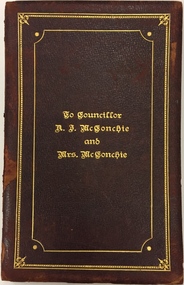
Document - Invitation, To Councillor A.J. McConchie and Mrs McConchie, 1928
Alan J. McConchie, a manufacturer’s agent, was elected to Kew Council in 1924, serving as a councillor for 21 years. He was elected Mayor of Kew in 1927-28, and again in 1945-46. During his second term as Mayor, he gained the support of Council for a pre-school plan which was the first of its kind in Victoria. The scheme established nursery schools and kindergartens as an extension of the existing baby health centres. Alan McConchie was active in Methodist Church work, and was one of the founders of the East Kew church, of which he was a trustee for 29 years. He was well known in the district as a cricketer and was a founder and past president of the East Kew Bowling Club. A Resident of Strathalbyn Street, he died in 1945 aged 60, while attending morning service at the East Kew Methodist Church. He is buried in the Burwood Cemetery. Handmade illuminated invitation to a notable Kew Mayor and MayoressAn illuminated invitation sent to the Mayor and Mayoress of Kew, Cr. and Mrs. McConchie, by a Citizens Committee to a Ball in the Kew Recreation Hall on 26 July 1928. The double page invitation is encased in an embossed maroon leather cover. The invitation was donated to the Society by a descendant of the McConchies in 2014.Inscription Cover: "To Councillor A.J. McConchie and Mrs McConchie". Inside cover in watercolour: "The Chairman Councillor George Ramsay and Members of the Citizens Committee desire the honor of the Company of HIS WORSHIP THE MAYOR OF KEW AND MRS. McCONCHIE at a BALL to be held in the Kew Recreation Hall Tuesday 26th July 1928 at 8 P.M. Tendered to them as a mark of recognition of the services rendered to the City during their Mayoral Year 1927".cr. a. j. mcconchie, mayor of kew (1927-28, 1945-46) -
 Kew Historical Society Inc
Map, MMBW, River Yarra Beautification Schemes, c.1913
The Melbourne and Metropolitan Board of Works (MMBW) was established by an act of the Victorian Parliament in 1890 to prepare for and to implement a sewerage and water reticulation system across what was then inner Melbourne, its surrounding and middle distance suburbs, including Kew. The MMBW was disbanded in 1991.The map collection of the Kew Historical Society has at its core the historic maps assembled and originally stored in the City Engineer's Department of the City of Kew. These include maps in a number of scales. The vast majority of maps were produced by the MMBW in the first two decades of the twentieth century, and are solid working maps, backed by linen for durability. These maps are historically significant to Kew, the City of Boroondara and to the history of the development of state utilities in Victoria. A number of the Kew maps have additional details added by former municipal officers, including the levels reached by various floods. As these were working documents, information was added to them long after the period of their initial production and distribution.Map of the City of Kew showing part of the River Yarra Beautification Schemes. The map shows development to date and the flood levels reached in 1923 and 1924. This map may have been adapted from an earlier map, as most development in central Kew and Studley Park had occurred by this date yet numerous streets are not represented. Public buildings and institutions are clearly represented and named on the map as are significant public transport infrastructure (eg the Outer Circle railway).MELBOURNE AND METROPOLITAN BOARD OF WORKS / RIVER YARRA BEAUTIFICATION SCHEMES / SCHEME / SCALE 10 CHAINS TO AN INCHmelbourne & metropolitan board of works, mmbw maps, mmbw plans, city of kew, flood levels -- kew (vic.), cartography -
 University of Melbourne, Burnley Campus Archives
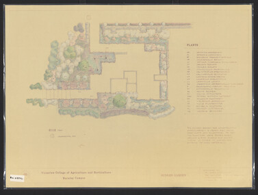
Plan, James Hitchmough, Sunken Garden, 1981-1989
Most plans were held in Geoff Olives's office.(1) Sunken Garden. 1 tracing paper copy and 1 paper, laminated, coloured. Designed by Dr. James Hitchmough, drawn by Jill Kellow c1989. Plants supplied by Victorian Wholesale Nurseries Pty. Ltd. (2) The Sunken Garden. 1 tracing paper, partly coloured, 1 paper copy. Designed by James Hitchmough, drawn by Jill Kellow 20.12.1988. (3) Burnley Horticultural College Gardens Development Sunken Gardens: Plan Proposal I, March 1981 on tracing paper. (4) Burnley Horticultural College Gardens Development Formal Sunken Garden Proposal 2, March 1981 on tracing paper. (5) Burnley Horticultural College Sunken Garden Scheme II by G. Olive on tracing paper. Plants supplied by Victorian Wholesale Nurseries P.L. sunken garden, james hitchmough, jim kellow, andrew smith -
University of Melbourne, Burnley Campus Archives
Plan, Swan Street Entrance. Also see B15.0352, 1988-1998
(1) 1 coloured and 2 copies, hand drawn , and 4 tracing paper sketches. Concept and Drawing by Steve Mullany, Lecturer V.C.A.H. Burnley, 09.12.1988. (2) 2 copies on tracing paper, original on paper with some additional notation and 3 copies of Landscape Plan by Steve Mullany 3 Feb 1989. (3) Photocopy of Project Eden, Swan Street, Richmond - Landscape Plan LA2 Project No 682 by Mark Mc Wha Pty. Ltd. Nov 1997. Includes Irrigation and Plant Schedule. (4) Coloured, Swan St Frontage Planting Scheme by P. Tulk for AMRAD 19.2.1998. -
University of Melbourne, Burnley Campus Archives
Plan, [Plans for Extensions to Student Amenities Building], 1996-2001
... (1) External paving & footing plan - Proposed outdoor...) External paving & footing plan - Proposed outdoor eating plan ...(1) External paving & footing plan - Proposed outdoor eating plan at Student Amenities Block, Victorian College of Agriculture & Horticulture. For - Burnley Student Association (Ross Greer Consultants P/L). Includes design modifications 2001. (2) Proposed outdoor eating area Student Amenities Block, VCAH. Schemes 1-8. (Includes plans for pergola, terrace, etc.) (3) Quotes from landcraft for landscape works around canteen (including ramps.) (4) John Stephens Catering Equipment Pty. Ltd. - Burnley Student Union. Plan View 1:20. Many copies of most documents including amendments.amenities, students, vcah, burnley -
 Vision Australia
Administrative record - Text, Ninth Annual Report of the Association for the Advancement of the Blind 1904, 1904
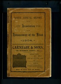
Annual report of the Association for the Advancement of the Blind outlined activities and events over the year, including an increase of membership to 150, the unfortunate illness of Mr Holgate, that attendance at meetings has improved due to the possible transfer of them into the city, the Secretary is now paid for their work due to the amount required, a number of goods designed for the blind have been imported by the Association from England and are being sold, some of which (the embossed music) has formed the beginning of a small music braille library, instruction in light handicrafts in the homes of the blind is continuing and now includes a knitting machine, concerts are still being undertaken with the focus on publicity for the Association and covering performing fees rather than as a fundraiser, and there are plans to create a fund scheme for sick workers.1 volume of printed material with some illustrationsassociation for the advancement of the blind, annual reports -
 Vision Australia
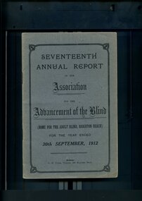
Administrative record - Text, Seventeenth Annual Report of the Association for the Advancement of the Blind 1912, 1912
Annual report of the Association for the Advancement of the Blind outlined activities and events over the year, including membership of 333, with the support of Mrs W.H. Edgar and the Lady Mayoress of Melbourne, 'Woodburn' was purchased and there were sufficient funds to reconstruct a wing to the present brick building, and plans are being drawn up under the supervision of Mr Paterson for some necessary extensions, the North Melbourne and Essendon Electric Tramway and Northcote Cable Tramway were added to the Railway Pass concession scheme, a successful concert tour was made of the Goulburn Valley from Alexandra down to the Murray, the loss of Mr Bacon - who was the first Blind Collector appointed by the Association - and Mrs May Harrison, VABW secretary who tirelessly promoted the welfare of the blind.1 volume of printed material with some illustrationsassociation for the advancement of the blind, annual reports -
 Falls Creek Historical Society
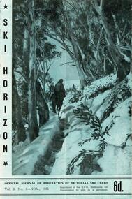
Journal - Ski-Horizon Vol. 3 No 3
Ski-Horizon is the official journal of the Federation of Victorian Ski Clubs which began publication in 1949. The were 26 original member clubs which included Albury Ski Club, Bogong Ski Club, Myrtleford Ski Club, Tallangatta and District Ski Club and Wangaratta Ski Club. Two pioneers of Falls Creek, Tom Mitchell, M.L.A., and Martin Romuld were Vice-Presidents of the Federation.This Journal is significant because it documents the early development of skiing in Victoria.The journal features stories and events chronicling developments in Victoria and internationally. Items related to the Falls Creek Area in this publication include:- Page 2: The road to Falls Creek from Howmans Gap likely to be closed while activities on the Kiewa Hydro Electric Scheme are restricted due to VIctoria's lack of finance for public works. Page 5 - A note from Fred Griffith (President, Albury Ski Club) gave plans for the club's annual Ski Ball on Friday, 30th November. It will be held in the Toonallook Woolshed. Fred says you are welcome to bring your sleeping bag and stay the night (what's left of it) at Toonallook where the recovery from hangover can be spent very pleasantly on the property or swimming and boating on the Hume Weir nearby. - N.E.D.S.A. officials are getting preparations in hand for the visit next year of a N.E.D.S.A. team to New Zealand. John Robertson, of Myrtleford Ski Club, is the Trip Secretary and Toni St. Elmo is acting at present as Manager.ski history victoria, federation of victorian ski clubs, ernest forras -
 Falls Creek Historical Society
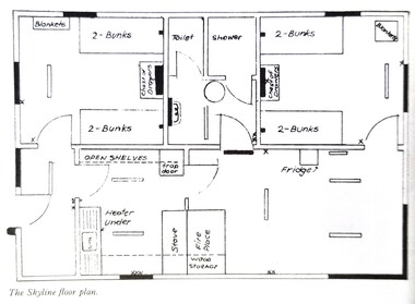
Plan - Floor plan Skyline Lodge, Bogong High Plains
MEYER COLLECTION - FALLS CREEK PHOTOS In 1947 a determined group of like-minded State Electricity Commission (SEC) staff including Ray Meyer, the chief surveyor of the Kiewa Hydro-Electric Scheme, had a common interest that revolved around the skiing potential of the snow-covered high plains which included what is now the resort of Falls Creek. The six SEC employees, Toni St Elmo, Ray Meyer, Jack Minogue, Lloyd Dunn, Adrian Ruffenacht and Dave Gibson (together with their families) banded together to secretly build a 'hut' that was the first ski lodge at Falls Creek. Using a road built in 1930s to gain access to Falls Creek, their hut project was carried out in secret as efforts by other skiers were blocked by H.H.C. Williams – the engineer in charge of the Hydro Scheme. In 1946 Ray Meyer made a trip to the Lands Office in Melbourne. He came away with a 99-year lease on three acres that was ideally suited for a hut designed by Lloyd Dunn. Adrian Ruffenacht (Design Engineer for the KHS) had suggested where the group should build because of easy access to a spring for water. Much of the building material required was scavenged from derelict huts on the high plains. Due to the need for secrecy, the determined group worked on the hut in the evenings and weekends to avoid detection. During the building period the group had met at Echidna Rock (now known as Eagle Rock) where Skippy St Elmo announced, "This is my favourite ‘Skyline’.” And so the first lodge in the area at Falls Creek Ski Resort came into existence. With the development of the International Poma in the 1970s, the Skyline Lodge, which was sited between the ski-lift’s pole one and pole two, was demolished. However, the legacy of Ray Meyer, Toni St Elmo, Jack Minogue, Lloyd Dunn, Adrian Ruffenacht and Dave Gibson and Skyline lives on in the vibrant atmosphere of Falls Creek Resort. The MEYER COLLECTION documents developments on the Kiewa Hydro Scheme and their life at Falls Creek from the mid 1930s to 1960s.This image is significant because it depicts developments made to "Skyline", the first lodge at Falls Creek.A floor plan of Skyline Lodge, probably after renovations were carried out by the Ski Club of Victoria which bought in to Skyline in 1950. In 1951 - 1952 a road up to the Lodge as well as drains, trenches and culverts were added. renovations to the lounge, basement drainage and porch resurfacing were completed in 1955. falls creek, victorian snowfields, skyline lodge -
Friends of Ballarat Botanical Gardens History Group
Work on paper - Plans for Fencing the Ballarat Botanical Gardens, 2002, Problems With Vandalism and Theft, March, 2003
Fencing of Ballarat Botanical Gardens, because of problems with vandalism and theft. The reasons for the fencing of the Botanical Gardens are stated along with the aim to have the fencing appropriate to the style of the Gardens.2 pages. p.2 has plans on both sides of the page. Wendouree Parade fencing, p.2 and Proposed Fencing Scheme, p.3.The three pages have the Begonia logo in black and white with Ballarat Botanical Gardens superimposed and by Lake Wendouree below in smaller print.john garner collection, garner, dr, fence, vandalism, ballarat botanical gardens, ballarat, gardens, theft, proposed fencing scheme, wendouree parade fencing, elevation detail, adam parrott, ballarat city council, local law no.6, south gardens boundary, lych gates, elevation detail. -
 Bacchus Marsh & District Historical Society
Map, Lerderderg District Proposed Irrigation and Water Supply Trust (C). Plan showing overlap in boundaries of the Trust District
The 1886 Irrigation Act in Victoria introduced the first legislation in Australia designed to enable the creation of a detailed scheme for agricultural irrigation. Part of the legislation saw the use of government funds for local irrigation projects. These local projects were managed by local irrigation trusts. The Lerderderg Irrigation and Water Supply Trust was formed in 1890. Printed paper map of the proposed Lerderderg District Irrigation and Water Supply. Plan showing overlap in boundaries of Trust District referred to in Mr Burke's report. The Lerderderg District lies within the Parishes of Korkuperrumul and Merrimu in the County of Bourke. At the top of the map above its title is the letter 'C; in capital lettering. A note on this map states: 'Portion of Bacchus MarshUrban District included in area of proposed Trust District shown by hatched shaded lines thus /////////////irrigation, water supply, lerderderg irrigation and water supply trust -
 Bacchus Marsh & District Historical Society
Map, Lerderderg District Proposed Irrigation and Water Supply Trust (A). Plan showing boundaries of Trust District
The 1886 Irrigation Act in Victoria introduced the first legislation in Australia designed to enable the creation of a detailed scheme for agricultural irrigation. Part of the legislation saw the use of government funds for local irrigation projects. These local projects were managed by local irrigation trusts. The Lerderderg Irrigation and Water Supply Trust] was formed in 1890. This map depicts the proposed area of the Trust.Printed paper map of the proposed Lerderderg District Irrigation and Water Supply. Plan showing boundaries of Trust District. The Lerderderg District lies within the Parishes of Korkuperrumul and Merrimu in the County of Bourke. At the top of the map above its title is the letter 'A; in capital lettering. Scale: 40 Chains = 1 inch.irrigation, water supply, lerderderg irrigation and water supply trust -
 Wodonga & District Historical Society Inc
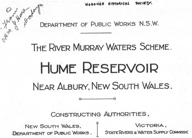
Album - Hume Reservoir Australia Album - Title Page, Department of Public Works, N.S.W, 1927
This set of photos is from a leather bound album bearing the inscription "HUME RESERVOIR AUSTRALIA" plus 'The Rt. Hon. L. C. M. S. Amery, P. C., M .P.' all inscribed in gold. It was presented to The Rt. Hon. L. C. M. S. Amery, P. C., M. P, Secretary of State for Dominion Affairs on the occasion of his visit to the Hume Reservoir on 2nd November 1927. To ensure preservation of the album and its contents, the images and information pages have all been digitised. It is assumed that over the past 70 to 80 years there has been some loss of contrast due to fading, and probably detail. Thus, each photo was enhanced in several steps. Digitalisation of the album was completed by Eric Eulenstein in Wodonga in April 2002. The position of Secretary of State for Dominion Affairs was a British cabinet-level position created in 1925 and responsible for British relations with the Dominions — Canada, Australia, New Zealand, South Africa, Newfoundland, and the Irish Free State — and the self-governing Crown colony of Southern Rhodesia.This album is of local and national significance as it documents the planning and development of the Hume Reservoir up to 1927. It was the largest water reservoir in the British Empire. The album records the pioneering engineering work that went into its construction.Title page of album, including official name and construction authorities."DEPARTMENT OF PUBLIC WORKS N.S.W./ (FROM MRS J. HORE WODONGA) /THE RIVER MURRAY WATER SCHEME./ HUME RESERVOIR NEAR ALBURY, NEW SOUTH WALES/CONSSTUCTING AUTHORITIES,/ NEW SOUTH WALES/DEPARTMENT OF PUBLIC WORKS/VICTORIA/STATE RIVERS & WATER COMMISSION"hume reservoir australia, river murray waters scheme -
 Wodonga & District Historical Society Inc
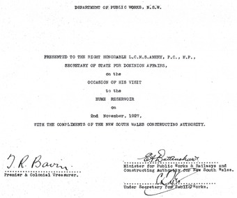
Album - Hume Reservoir Australia Album - Dedication, Department of Public Works, N.S.W, 1927
This set of photos is from a leather bound album bearing the inscription "HUME RESERVOIR AUSTRALIA" plus 'The Rt. Hon. L. C. M. S. Amery, P. C., M .P.' all inscribed in gold. It was presented to The Rt. Hon. L. C. M. S. Amery, P. C., M. P, Secretary of State for Dominion Affairs on the occasion of his visit to the Hume Reservoir on 2nd November 1927. To ensure preservation of the album and its contents, the images and information pages have all been digitised. It is assumed that over the past 70 to 80 years there has been some loss of contrast due to fading, and probably detail. Thus, each photo was enhanced in several steps. Digitalisation of the album was completed by Eric Eulenstein in Wodonga in April 2002. The position of Secretary of State for Dominion Affairs was a British cabinet-level position created in 1925 and responsible for British relations with the Dominions — Canada, Australia, New Zealand, South Africa, Newfoundland, and the Irish Free State — and the self-governing Crown colony of Southern Rhodesia.This album is of local and national significance as it documents the planning and development of the Hume Reservoir up to 1927. It was the largest water reservoir in the British Empire. The album records the pioneering engineering work that went into its construction. Hume Reservoir Australia Album - Dedication page recording the presentation of the album to 'The Rt. Hon. L. C. M. S. Amery, P. C., M.P" and his visit to Albury in 1927. “DEPARTMENT OF PUBLIC WORKS, N.S.W./ PRESENTED TO THE RIGHT HONOURABLE L.C.M.S. AMERY, F.C., M.P.,/ SECRETARY OF STATE FOR DOMINION AFFAIRS/ on the/ OCCASION OF HIS VISIT/ to the /HUME RESERVOIR/ on/ 2ND NOVEMBER 1927, /WITH THE COMPLIMENTS OF THE NEW SOUTH WALES CONSTRUCTING AUTHORITY./(SIGNED) T.R. BAVIN, Premier & Colonial Treasurer./ E.A. BATTENSHAW, Minister for Public Works & Railways and Constructing Authority for New South Wales/ C. TYLE, Under Secretary for Public Works”hume reservoir australia, river murray waters scheme -
 Wodonga & District Historical Society Inc
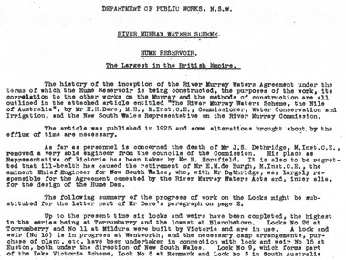
Album - Hume Reservoir Australia Album - Introduction - Part 1, Department of Public Works, N.S.W, 1927
This set of photos is from a leather bound album bearing the inscription "HUME RESERVOIR AUSTRALIA" plus 'The Rt. Hon. L. C. M. S. Amery, P. C., M .P.' all inscribed in gold. It was presented to The Rt. Hon. L. C. M. S. Amery, P. C., M. P, Secretary of State for Dominion Affairs on the occasion of his visit to the Hume Reservoir on 2nd November 1927. This album is of local and national significance as it documents the planning and development of the Hume Reservoir up to 1927. It was the largest water reservoir in the British Empire. The album records the pioneering engineering work that went into its construction.RIVER MURRAY WATERS SCHEME, HUME RESERVOIR THE LARGEST IN THE BRITISH EMPIRE. ' The history of the inception of the River Murray Waters Agreement under the terms of which the Hume Reservoir is being constructed, the purposes of the work, its correlation to the other works on the Murray and the methods of construction are all outlined in the attached article entitled “The River Murray Waters Scheme, the Nile of Australia”, by Mr H.H. Dare, M.E., M.Inst.C.E., Commissioner, Water Conservation and Irrigation, and the New South Wales Representative on the River Murray Commission. The article was published in 1925 and some alterations brought about by the efflux of time are necessary. As far as personnel is concerned, the death of Mr J.S. Dethridge, M.Inst.C.E., removed a very able engineer from the councils of the Commission. His place as Representative of Victoria has been taken by Mr R. Horsfield. It is also to be regretted that ill-health has caused the retirement of Mr E.M. de Burgh, M.Inst.C.E., the eminent Chief Engineer for New South Wales, who, with Mr Dethridge, was largely responsible for the Agreement cemented by the River Murray Waters Acts and, inter alia, for the design of the Hume Dam. The following summary of the progress of work on the Locks might be substituted for the latter part of Mr Dare’s paragraph. Up to the present time six locks and weirs have been completed, the highest in the series being at Torrumberry and the lowest at Blanchetown. Locks No.26 at Torrumberry and No.11 at Mildura were built by Victoria and are in use. A lock and weir (No.10) is in progress at Wentworth, and the necessary camp arrangements, purchase of plant, etc., have been undertaken in connection with lock and weir No.15 at Euston, both under the direction of New South Wales. Lock No.9, which forms part of the Lake Victoria Scheme, Lock No.5 at Renmark and Lock No.3 in South Australia hume reservoir australia, river murray waters scheme -
 Wodonga & District Historical Society Inc
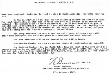
Album - Hume Reservoir Australia Album - Introduction - Part 2, Department of Public Works, N.S.W, 1927
This set of photos is from a leather bound album bearing the inscription "HUME RESERVOIR AUSTRALIA" plus 'The Rt. Hon. L. C. M. S. Amery, P. C., M .P.' all inscribed in gold. It was presented to The Rt. Hon. L. C. M. S. Amery, P. C., M. P, Secretary of State for Dominion Affairs on the occasion of his visit to the Hume Reservoir on 2nd November 1927. This album is of local and national significance as it documents the planning and development of the Hume Reservoir up to 1927. It was the largest water reservoir in the British Empire. The album records the pioneering engineering work that went into its construction.DEPARTMENT OF PUBLIC WORKS, N.S.W. (continued from previous image). have been completed, Locks Nos. 2, 4 and 6, also in South Australia, are under construction. In the description of the Hume Dam the following emendations have to be made. The total length will be 5,300 feet of which 4,258 feet will consist of an earthen embankment. The maximum depth of water conserved will be 24 feet more than originally intended with an additional allowance of 9 feet for surcharge, the total capacity will be 2,000,000 acre feet, the water surface at full supply level 44,000 acres, and provision is being made for a flood discharge of 182,000 cusecs. For handy reference, the main dimensions and figures and comparisons with other dams throughout the world are given in a tabulated statement attached. The Hume Reservoir will be the largest in the British Empire. Photographs showing the work at various stages of construction are appended. The Resident Engineer for New South Wales from the start of the work until his recent promotion to the position of Inspecting Engineer was Mr J. Keith Ross, M.A., B.Sc., A.M.Inst.C.E., who has been succeeded by Mr S.W. Jones, B.E., A.M.Inst.C.E. The Resident Engineer for Victoria is Mr A.W. Johnson, B.E. (Signed) M. Inst.C.E. Chief Engineer New South Wales Constructing Authority 27th October 1927. hume reservoir australia, river murray waters scheme -
 Wodonga & District Historical Society Inc
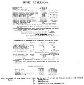
Album - Hume Reservoir Australia Album - Dimensions of Hume Reservoir, Department of Public Works, N.S.W, 1927
This set of photos is from a leather bound album bearing the inscription "HUME RESERVOIR AUSTRALIA" plus 'The Rt. Hon. L. C. M. S. Amery, P. C., M .P.' all inscribed in gold. It was presented to The Rt. Hon. L. C. M. S. Amery, P. C., M. P, Secretary of State for Dominion Affairs on the occasion of his visit to the Hume Reservoir on 2nd November 1927. This album is of local and national significance as it documents the planning and development of the Hume Reservoir up to 1927. It was the largest water reservoir in the British Empire. The album records the pioneering engineering work that went into its construction.Table outlining the Dimensions of the Hume Weir and comparisons with MAKWAR and BURRINJUCK DAMS, and some other comparisons. MAKWAR Dam is located on the Blue Nile about five miles south of Sennar and 175 miles south of Khartoum in Sudan. The construction of this dam started in 1922 and was completed in May 1925, while the British Empire colonised Sudan. It was officially opened on 21st January 1926. The BURRINJUCK DAM is situated in the upper catchment of the Murrumbidgee River, approximately 60 kms from Yass, N.S.W. It was built from 1907 to 1927 The stated purpose of the Hume Reservoir is to get storage to ensure regulated output for:- 1. Irrigation 2. Navigation 3. Hydro-electric Generation.hume reservoir australia, river murray waters scheme, hume dimensions -
 Wodonga & District Historical Society Inc
Album - Hume Reservoir Australia Album - Plans and Progress Photos - River Murray Water Scheme, Department of Public Works, N.S.W, 1927
This set of photos is from a leather bound album bearing the inscription "HUME RESERVOIR AUSTRALIA" plus 'The Rt. Hon. L. C. M. S. Amery, P. C., M .P.' all inscribed in gold. It was presented to The Rt. Hon. L. C. M. S. Amery, P. C., M. P, Secretary of State for Dominion Affairs on the occasion of his visit to the Hume Reservoir on 2nd November 1927. This album is of local and national significance as it documents the planning and development of the Hume Reservoir up to 1927. It was the largest water reservoir in the British Empire. The album records the pioneering engineering work that went into its construction.1. Locality Plan and Plan of Dam. The dam is about ten miles by road upstream from Albury and about three-quarters of a mile below the confluence of the Mitta Mitta River and the Murray River. Its main features consist of a concrete portion across the bed of the river with earth embankment at both ends. The foundations throughout are on hard granite, found at an average depth of about 40 feet below the surface, the centre line being located to take advantage of the most favourable rock levels.Heading on page "WORKS UNDER RIVER MURRAY WATERS AGREEMENT/HUME RESERVOIR" Beneath top diagram "FIG. 1. ELEVATION" Beneath second diagram "FIG. 2. PLAN" On map "LOCALITY PLAN"hume reservoir australia, river murray waters scheme, hume weir diagrams, hume weir location -
 Wodonga & District Historical Society Inc
Album - Hume Reservoir Australia Album - Detail plan and explanation, Department of Public Works, N.S.W, 1927
This set of photos is from a leather bound album bearing the inscription "HUME RESERVOIR AUSTRALIA" plus 'The Rt. Hon. L. C. M. S. Amery, P. C., M .P.' all inscribed in gold. It was presented to The Rt. Hon. L. C. M. S. Amery, P. C., M. P, Secretary of State for Dominion Affairs on the occasion of his visit to the Hume Reservoir on 2nd November 1927. This album is of local and national significance as it documents the planning and development of the Hume Reservoir up to 1927. It was the largest water reservoir in the British Empire. The album records the pioneering engineering work that went into its construction.2. Detail Plan and Section. Starting from the New South Wales and there will be an earthen embankment 430 feet 6 inches long which is retained by the North Wing Wall. Then come the sluice section 284 feet 3 inches long, the spillway 720 feet long and the South Wing Wall, making a total length of 1,042 feet 6 inches of concrete wall. Beyond the South Wing Wall is earth embankment again to a length of 3,827 feet. The Full Supply Level is R.L.626.00 and allowance has been made for a surcharge of 9 feet. A road will run along the top of the dam at R.L.642.00. The sluice section contains seven offlets, the three nearest the north wing wall being 13 feet in diameter for hydro-electric purposes and the other four 9 feet in diameter for regulation purposes only. There are to be stony sluice gates on the upstream ends of the outlets and needle valves on the downstream ends. The shock of the discharged water will be taken by a stilling pool. Trash racks will protect the intake ends of the outlets. Next comes the spillway section, which is curved on the downstream face, and carried up to within 15 feet of the full supply level. Above that will be a series of piers between which will be the flood gates and on top of which the roadway will be carried. The gates will be 20 feet wide and 15 feet high and will be 29 in number. They will slide down the face of the wall when opened for the escape of the water. The investigation of the control of this cascade of water was made by means of a model and as a result the form of “bucket” or energy dissipater shown on the section of the spillway was decided upon. The earth embankment in Victoria is being constructed by the State Rivers and Water Supply Commission of Victoria who are the Constructing Authority for that State under the River Murray Waters Agreement. The core of the embankment is of concrete 6 feet wide at the base tapering to 2 feet at the top end and is reinforced with steel rods from the level of the decomposed rock upwards. On the downstream side, at about natural surface level, is a tunnel for drainage and inspection purposes. Above the tunnel is a vertical layer of large stones to drain any seepage to the tunnel. Against the core wall is packed selected material of as impervious a character as can be got locally and beyond that the bank is carefully built up in horizontal layers by means of horses and wheel scoops. The upstream slope is 3-to-1 hardening to 2½-to-1 at the top and the downstream slope is 2½-to-1 hardening to 2.07-to-1 at the top. The thrust of the upstream toe is taken by a mass of granite blocks, and this face is protected by concrete laid in situ. The width of the bank at base is 650 feet and at top 32 feet.hume reservoir australia, river murray waters scheme, hume weir diagrams, hume plan details -
 Wodonga & District Historical Society Inc
Album - Hume Reservoir Australia Album - Hume Reservoir Detailed diagrams, Department of Public Works, N.S.W, 1927
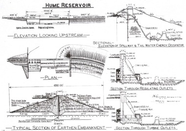
This set of photos is from a leather bound album bearing the inscription "HUME RESERVOIR AUSTRALIA" plus 'The Rt. Hon. L. C. M. S. Amery, P. C., M .P.' all inscribed in gold. It was presented to The Rt. Hon. L. C. M. S. Amery, P. C., M. P, Secretary of State for Dominion Affairs on the occasion of his visit to the Hume Reservoir on 2nd November 1927. This album is of local and national significance as it documents the planning and development of the Hume Reservoir up to 1927. It was the largest water reservoir in the British Empire. The album records the pioneering engineering work that went into its construction.6 Diagrams showing the details of the Hume Reservoir structure. On the left from the top of the page to bottom are:- ELEVATION LOOKING UPSTREAM, PLAN aTYPICAL SECTION OF EARTHEN EMBANKMENT. ' On the right from top to bottom are:- SECTIONAL - ELEVATION OF SPILLWAY & TAIL WATER ENERGY DISSIPATOR, SECTION THROUGH REGULATING OUTLETS and SECTION THROUGH TURBINE OUTLETS.hume reservoir australia, river murray waters scheme, hume weir diagrams, hume plan details