Showing 517 items matching " south red white "
-
 The Dunmoochin Foundation
Oil Painting, Judith 3/68 South Audley St London, 1975
Painting of a woman with short red hair seated by a window and wearing a white nightgown. Inscribed (Ll) 'Judith, 3/68 South Audley St, London W1 and signed 'Clifton Jan 75'.clifton pugh, judith, london, portrait, painting -
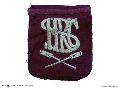 Albert Park-South Melbourne Rowing Club
Pocket, blazer, Club Crest
From the Wal Graham Collection.A red woollen blazer pocket with white embroidered letters.SMRC -
 National Wool Museum
Textile - O*So*Lite Self-Raising Flour Bag
These domestic kitchen bags were donated to the National Wool Museum by Lila Gore. Lila donated Children’s Clothing (RGE 8324) to the museum in 2022 and at her time of donating, inquired as to whether the museum would also be interested in these bags she had been collecting. Lila said there was no reason as to why she was saving the bags, other than she liked the art works and thought they were too good to end up in landfill. She had thought perhaps she would make something out of the bags, or perhaps give the bags to a friend to make something. When Lila was donating the Children’s Clothing to the museum, she thought that the National Wool Museum would be the perfect home for the bags. Domestic kitchen bags such as these date from the late 19th century through the mid-20th century. They were used at home, usually by women, containing household items which would not spoil, such as flour, sugar, animal feed, seeds, and other commodities. In modern times a trip to the supermarket is a daily chore, in the past however, these trips happened far less often, with big sacks such as these a large reason why. In the rural US and Canada, Feed sack dresses and Flour sack dresses, were an iconic part of rural life from the 1920s through the Great Depression, World War II, and post-World War II years. Australia also reused these sacks, typically for making wagga style blankets, but re-use for clothing was not unusual.Calico flour bag with red, blue, white and yellow graphic image and text. Image shows head and shoulders of a woman wearing a bakers hat. Reverse side shows same image with slightly different text.Front: O*SO*LITE \ SELF-RAISING \ FLOUR \ 25lb \ NET \ THE \ FINEST \ FLOUR \ O-SO-LITE \ PRODUCTS PTY. LTD. \ LENNON STREET, SOUTH KENSINGTON \ VICTORIA 13 0261 \ SELF RAISING \ SELF RAISING \ SELF RAISING Back: O*SO*LITE \ SELF-RAISING \ FLOUR \ PREPARED WITH PROSPHATE AERATOR \ 25lb \ NET \ THE \ FINEST \ FLOUR \ O-SO-LITE \ PRODUCTS PTY. LTD. \ LENNON STREET, SOUTH KENSINGTON \ VICTORIA 13 0261wagga, flour, oats, bag, calico, lila, gore, depression, war, kitchen -
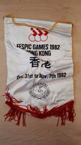 Vision Australia
Flag - Object, 1982 Fespic Games banner
Souvenir mini banner from the 1982 Fespic Games in Hong Kong.White satin mini banner with black writing and red fringingFespic Games 1982 Hong Kong Oct. 31st to Nov. 7th 1982recreation, royal blind society of new south wales -
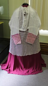 Ballarat Diocesan Historical Commission
Surplice, Bishop's surplice
The surplice is a liturgical vestment in the form of a tunic of white linen or cotton fabric, reaching to the knees, with wide or moderately wide sleeves. The lower segment is usually lace or lace trimmed. In this case it is hand crocheted. Here too the cuffs of the sleeves are lace trimmed backed with red silk to denote the rank of the wearer, in this case a bishop. -
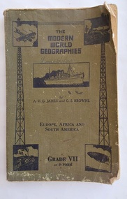 Mont De Lancey
Book, The Specialty Press Pty. Ltd. et al, The Modern World Geographies Grade VII or F Form, c 1938
The Modern World Geographies: Europe, Africa and South America Grade VII or Form F is part of a series of six little books of geographical information for children between the ages of eight and fourteen written by very experienced teachers and educationalists. They are readers rather than textbooks with the object of stimulating interest and to leave to the teacher the filling in of the course by appropriate lessons.A faded khaki green softcover reader or textbook with black lettering on the front cover at the top for the title The Modern World Geographies, Europe, Africa and South America Grade VII or Form F. A black and white illustration of a steamship and four other pictures are printed on the damaged front cover. Throughout are black and white charts, maps, diagrams, photographs and illustrations. In red ink writing inside on the front endpaper is Lance Sebire. Dog eared pages with a damaged worn cover and stains. Lance Sebire is written again on the back cover.226p.non-fictionThe Modern World Geographies: Europe, Africa and South America Grade VII or Form F is part of a series of six little books of geographical information for children between the ages of eight and fourteen written by very experienced teachers and educationalists. They are readers rather than textbooks with the object of stimulating interest and to leave to the teacher the filling in of the course by appropriate lessons.children's books, readers, geography, textbooks -
 Kilmore Historical Society
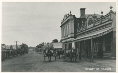
Photograph, Sydney Street Looking South, 1912
12.5cm x 20cm black and white photograph looking south on Sydney Street. Can be seen is original building which are now demolished. Also can be seen is: Morrissey Butchers, J.Loft Railway Hotel, Bullivant, some unidentified building and the Red Lion Hotel. Also in the picture are horse drawn vehicles and people walking on the footpaths, and power poles. One copy of the image is mounted on archival board.Written on the back of the mounting: 104/1.22 20486/1-22 Looking South Sydney St Kilmore Shops now demolished on left From right Morrissey Butchers, J. Loft Railway Hotel, Bullivant ?, ?, ?, Red Lion Hotel. R.J. Fagg. 17 Link Avenue, Kilmore 3601 Written on the back of one copy: 104/1.22 22 200486/1 22 P.C. Sydney Str. looking south 1912 Kilmore Historical Societyshopfronts, storefronts, retail stores -
 Kilmore Historical Society
Photograph, Looking South on Sydney Street from Union Street, 1860
25cm x 20cm black and white photograph of South-West Sydney Street. The buildings that can be seen include Kilmore Timber Yard, Riche Fitzgerald & Co Builders Ironmoncery, Red Lion Hotel. Pictured are people standing under the awning of the Ironmongers. Picture was taken in 1860. This picture is a copy from LaTrobe.Written on the back: Kilmore Historical Society #4.#5.10/86-33 Copy LaTr. 1860 Trainor's Store etc. looking south-west from Union St.shopfronts, storefronts, retail stores, 19th century -
 Mont De Lancey
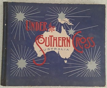
Book, William Applegate Gullick, Under the Southern Cross Australia, 1911
A non fiction book showing full page black and white photograph glimpses of the six states and one territory of Australia in 1910. The ACT is not shown as it was not a territory until 1911. There is simple text describing each photograph at the top and bottom of each page.A blue covered rectangular hardcover book titled in red text and black text on the front cover - Under the Southern Cross with a white map of Australia and Papua with five grey stars of varying sizes with lined rays around each one. Inside on the title page is printed, Glimpses of Australia - Issued under the the direction of the GOVERNMENT OF THE COMMONWEALTH OF AUSTRALIA. Department of External Affairs, Melbourne 1910. On the back of the title page is printed Sydney: William Applegate Gullick, Government Printer for the state of New South Wales. 1911 above an ornate lined symbol. Opposite the title page is a detailed map of Australia showing six states, the Northern Territory but not the ACT which didn't become a territory until 1911. The ACT (Self-Government) Act 1988 established the framework for the ACT Self-government.non-fictionA non fiction book showing full page black and white photograph glimpses of the six states and one territory of Australia in 1910. The ACT is not shown as it was not a territory until 1911. There is simple text describing each photograph at the top and bottom of each page.australia, australian states, australian territory, australian life, australian cities -
 Wodonga & District Historical Society Inc
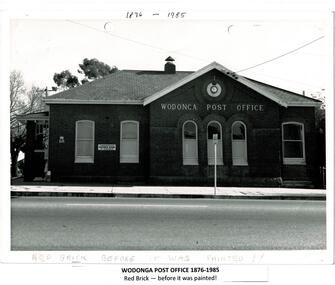
Photograph - Codling Collection 01 - Wodonga Post Office
Miss Olive Codling was a Foundation Member and a Life Member of the Wodonga Historical Society. Many of her photos are held in the Society Collection. The Wodonga Post Office was constructed on the corner of Sydney Road (High Street) and South Street in 1874. It was Wodonga’s second Post Office. The original post office opened on June 1, 1856 near Wodonga Creek. This building was originally built of red brick, although it was later painted over in white. It had an attached residence in South Street and was connected to it by a door. The residence was later demolished to move the mail boxes which had faced High Street, to South Street. The brick Telephone Exchange was constructed in 1946 behind the Post Office but separated from it. It operated as a manual exchange until the late 1960’s or early 1970’s. In 1985 a new post office was opened further south in High Street. This building, greatly renovated, is now part of the Wodonga Community College.This photo collection is significant as it documents how the businesses and buildings in Wodonga have evolved and contributed to community throughout the 20th century. A black and white image of the 2nd Wodonga Post Office. There are 6 windows across the front of the building and the name Wodonga Post Office below a round clock. To the left of the building is the royal insignia of the crown above the letters E.R. A sign for the Commonwealth Saving Bank of Australia is also attached to the wall.high st wodonga, wodonga post office, businesses wodonga -
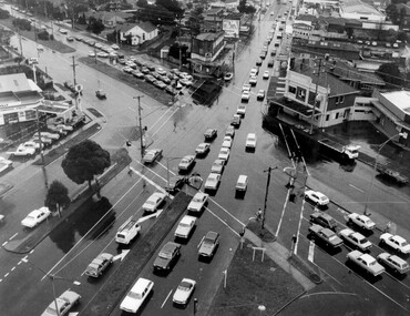
 City of Kingston
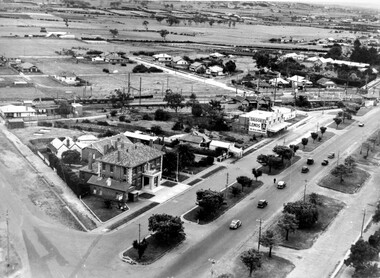
Photograph - Black and white, c. 1930
During the 1930s Moorabbin was an area with open grasslands, still often used for market gardening. The development of the city (and, later, suburb) can be seen emerging from the railway station.The Nepean Highway is a major highway running through the City of Kingston. This image is one of many that depicts its importance to the local community as it undergoes many changes over time.Black and white photograph of aerial view of intersection of Nepean Highway and South Road. Moorabbin Council Chambers are situated on the corner with the library, old shire building, Moorabbin railway station, St David's Anglican Church market gardens and open paddocks in the background.White round sticker on reverse with black printed text: 143 Handwritten in red ink on reverse: 156% / k000786moorabbin, council, railway station, railway, suburbs, paddocks, nepean highway -
 City of Kingston
Photograph - Black and white, c. 1950
The image shows a line of traffic travelling along South Road in response to traffic light signlas while an increasing number of cars are banking up along Nepean Highway, also in response to traffic light signals.This image provides a strong contrast to images from earlier eras of the same intersection. The amount of traffic has increased enormously as well as commercial development.Black and white photograph with an aerial view of the intersection of Nepean Highway and South Road, taken from above the Moorabbin Council Chambers.Handwritten in black ink Pic [indecipherable] / 1000 Handwritten in red ink: 150%moorabbin, traffic lights, cars, nepean highway -
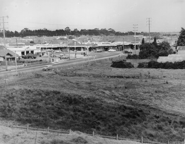 City of Kingston
Photograph - Black and white, c. 1963
This image depicts the intersection of increasing urbanisation and the rural landscape that once made up the area now known as City of Kingston.Black and white photograph of the intersection of Warrigal Road and Centre Road, South Oakleigh, viewed from the reservoir. In the foreground are paddocks and in the background is a shopping strip, including a petrol station.Handwritten in blue ink on reverse: 2196 Handwritten in red ink on reverse: 100%oakleigh, roads, shopping strip, paddocks -
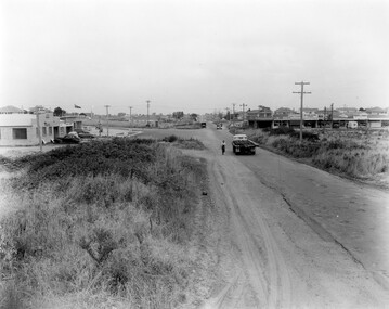
 City of Kingston
Photograph - Black and white, c. 1957
This image shows the urbanisation of a formerly rural area of Moorabbin.Black and white photograph looking west along South Road. There is a truck in the foreground, travelling along the sealed South Road. A car is waiting to exit from Rowan Road. People are walking along the left hand side of the road, and a young person a bike is riding along the right side. They are all going in the same direction as the traffic. The left hand side of the image shows paddocks in the foreground, which houses further back. The right hand side of the image shows suburban houses with electricity poles running the length of the road. Handwritten in blue ink on reverse: 57-523A Handwritten in red ink on reverse: 85% Handwritten in black ink or grey lead: Ch. 6moorabbin, cars, roads, housing -
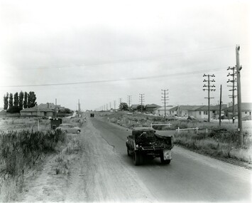
 City of Kingston
Photograph - Black and white, 1957
This image shows the increasing urbanisation of the formerly rural area of Moorabbin.Black and white photograph of the intersection of South Road and Chesterville Road, Moorabbin. A service station is visible on the left hand side, a truck is travelling along the road and shops are under construction on the right hand side.Handwritten in blue ink on reverse: 57-523B Handwritten in red ink on reverse: 100%moorabbin, shopping strip, paddocks, roads, cars -
 City of Kingston
Photograph - Black and white, c. 1957
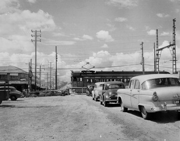
This image depicts the increasing urbanisation of Moorabbin. While there are several cars in line waiting for the train to go through the crossing and the gates to open, in the distance there is a lot of activity on the road, with many cars.Black and white photograph depicting the railway crossing at South Road, Moorabbin. There is a 'Red Rattler' passenger train going through the level crossing travelling towards the city.Handwritten in blue ink on reverse: 57-4078 Handwritten in red ink on reverse: 82% Handwritten in black ink on reverse: Ch. 6moorabbin, trains, cars, urbanisation, suburbs -
 City of Kingston
Photograph - Black and white, c. 1950
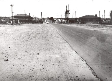
This image shows a sealed road running along South Road, although with a wide gravel shoulder. The railway crossing gates were hand operated. This image is one of many in the collections that focuses on the railway. The development of the railway was crucial to the ongoing development of the area. Community life often sprang up along and beside the railway.Black and white photograph of the railway crossing at South Road, Moorabbin, viewed from Nepean Highway. Handwritten in blue ink on reverse: 217 Handwritten in red ink on reverse: 80%moorabbin, railway, railway crossing -
 City of Kingston
Photograph - Black and white, 1950
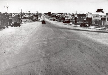
This photograph depicts the increasing urbanisation of a once rural area at Moorabbin.This image is one of many in the collections that focuses on either roads or the railway. The development of roads and the railway was crucial to the ongoing development of the area. Black and white photograph of South Road, Moorabbin, with Station Street to the right and Jasper Road further down to the left. Along both sides of the road are retail spaces which become homes on the left hand side, after Jasper Road.Handwritten in red ink on reverse: 80% Handwritten in blue ink on reverse: 216moorabbin, roads, cars, shopping strip, housing -
 City of Kingston
Photograph - Black and white, c. 1950
This image highlights the rural nature of the area during the 1950s where areas that are now major highways and intersections appear like country roads.Black and white photograph of the intersection of Warrigal Road and Centre Road in Oakleigh. There is a truck travelling south toward the camera along Warrigal Road which is a sealed road. On the right hand side is a Caltex petrol station with a street sign for Centre Road.Handwritten in blue ink on reverse: 2191 Handwritten in red ink on reverse: 72%oakleigh, cars, roads, suburbs -
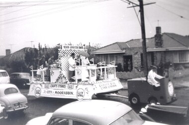 City of Kingston
Photograph - Black and white, 1962
Crofts Stores (a chain of grocery stores) entered this float in the City of Moorabbin centenary procession held in 1962. Crofts had several stores in the City of MoorabbinCrofts Stores was established by Archibald Crofts with a single grocers store in South Melbourne. It eventually expanded to include 137 branches throughout Victoria, trading as Crofts Stores. Several Crofts stores existed in the City of Moorabbin and the chain pioneered self-service food stores in Australia. In 1962 the City of Moorabbin celebrated its centenary, which was marked with a procession through the streetsBlack and white photograph of a float being driven down a busy street. There are five people aboard the float, three behind a counter, and two at the rear. There are small flags reading Crofts (the business name) all around the float. Signage along the long edge of the float reads 'Crofts Stores congratulates the City of Moorabbin 1962'. Signage along the front shorter side reads 'Famous for fine foods', and signage above the counter reads 'Your grocer 1962'. There are people visible on the front porch of a house in the background, watching the float pass. Cars are parked along either side of the road and are also travelling in the opposite direction to the float.Handwritten in red ink: 60%grocery, centenary, city of moorabbin -
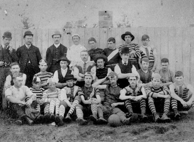 City of Kingston
Photograph - Black and white, c. 1908
Australian rules football began being played on a regular basis in Cheltenham in 1890. Teams would not only play locally but travel by train fairly long distances, such as to Ballarat, for the day, play a game, turn around and come home. The Cheltenham home games were played on a paddock on the corner of Park and Charman roads in Cheltenham. In 1907 the Cheltenham progress committee made an application to the board of land works for land in Weatherall Road for recreational service to the public. That application was received and granted, then developed where Cheltenham Recreational Reserve now stands. The ground was opened in 1909 and the first Cheltenham side entered in the newly formed Federal Football League along with seven other foundation members, Mordialloc, Mentone, Moorabbin, Frankston, Glenhuntly, Elsternwick, and Ellindale. The grand final for that year, 1909 was a hard encounter between Cheltenham and Ellindale with Cheltenham coming out victors, thus becoming the inaugural Federal Football League premiers. The Federal Football League (FFL), also known simply as the Federal League, was an Australian rules football competition in the south-eastern suburbs of Melbourne, Victoria. The competition was in existence from 1909 to 1981 and was regarded as one of the strongest metropolitan leagues in Melbourne.Black and white image of the players and officials of the Cheltenham Football Club. Back (left to right) G Puttick, Franklyn (sic), Unkown, Unknown, C Corstorphine, D Arland, Dave Hughes, H Bryant, Centre: T Elliott, S Parsons, F Judd, H Foreman, N Corstorphine, J McCormack, S Chandler, H Orr. Front: H Clayton - no other names recorded. The players are wearing what appears to be a range of club jumpers, with some in street wear. Some players seated in the front row have mud visible on the soles of their shoes, indicating they may have already played a gam. The ball on the ground in front of the group is round.Round red sticker on reverse with handwritten text: X10 Handwritten in blue ink: A11, with a circle around it Handwritten in red ink: 50%sport, football, cheltenham, teams, federal football league -
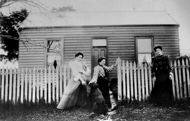 City of Kingston
Photograph - Black and white, c. 1910
The cottage was located on East Boundary Road, near Caleb Street in East Bentleigh. It was owned by Caleb Porter and occupied by Laura Johnson (centre). Also in the photograph are her sister Boletta Hansen Wold (left) and daughter Anna Marie Johnson (right). The dog's name has not been recordedPart of East Bentleigh was inside the original grant of land bought by English farmer and brewer, Henry Dendy, in 1841. He bought 5,120 acres (20.7 km2) which was bounded on the west by Port Phillip Bay, then North Road, East Boundary Road and South Road.Black and white image of three women and a dog standing outside a small weatherboard cottage with a picket fence. Round white sticker with black printed text: 140 Handwritten in red ink: 55%east bentleigh, caleb porter, laura johnson, boletta hansen wold, anna marie johnson -
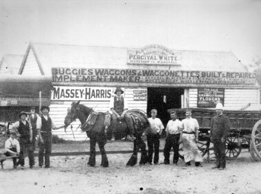 City of Kingston
Photograph - Black and white, c. 1910
Percival White was a blacksmith who set up shop in South Road, Moorabbin. The advertising on the front of the shop indicates he also made and repaired buggies, wagons, etc.Percival White opened his blacksmith shop in 1853. The business continued until 1973.Black and white image of a group of men, standing either side of a Clydesdale horse, in front of Percival White's shop in South Road, Moorabbin. The man to the far right appears to be in a military or police uniform. The man immediately next to him is wearing a long apron. There are two more men standing in a row and then the Clydesdale. There is a man sitting sideways on the horse. Another man is holding the horse by the reins. Another man is standing next to him, with his hands on his hips and another man, or boy, is seated. In the background there is another man with a long white beard.Handwritten in blue ink on reverse: 124 Handwritten in red ink on reverse: 55%moorabbin, blacksmith, repair -
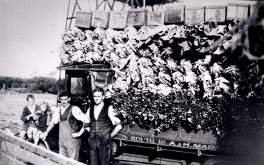 City of Kingston
Photograph - Black and white, c. 1920
Market gardening was an integral part of the development of the area now known as Kingston. In this image there are two men standing beside a truck loaded with vegetables. Painted on the truck are the words South Rd, A & H Marriott, indicating these men are from the Marriott family. The truck appears to be a Republic Commercial Car by Republic Motor Truck Co, Michigan, c. 1916.The Marriott family arrived in Port Phillip in 1857. It wasn't until 1876 that the family purchased 30 acres with a four-roomed house in East Boundary Road, in the area then called East Brighton.Black and white image of two men standing in front of a truck fully loaded with vegetables intended for market. There are also two children standing in front of the truck.Handwritten in black ink on a round red sticker on the reverse: X18 Handwritten in red ink on reverse: 35% -
 City of Kingston
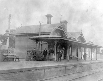
Photograph - Black and white, c. 1900
Moorabbin station was originally called South Brighton station and the name can be seen painted on the back of the bench seat on the platform. There are six men standing on the platform.Moorabbin station was opened on 19 December 1881 as South Brighton station. On 1 May 1907 it was renamed Moorabbin station and has maintained that name every since. Six men standing on the station at Moorabbin Railway Station.Stamped in blue ink on reverse: COPYRIGHT / Public Transport Corporation / For re-ordering photographs / Please quote negative No H3380 / Enquiries C/- PTC Photographic Unit / Telephone switchboard 619 111 Handwritten in red ink on reverse: 116 / ? % Handwritten in black ink on reverse: 50% Ch.4. Handwritten in blue pencil on reverse: H3380 -
 City of Kingston
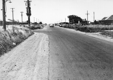
Photograph - Black and white, c. 1950
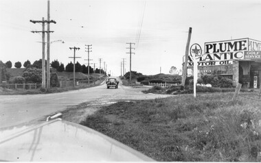
A car travelling along South Road Moorabbin, with the Tucker Road intersection on the left hand side. Houses are on either side of the road which also has wide shoulders and nature strips.A car travelling along a sealed road with wide shoulders and houses on either side of the road.Handwritten in red ink on reverse: 72% Handwritten in blue ink on reverse: 2192 [circle around all text, including red ink]transport, moorabbin, cars, houses -
 Melbourne Legacy
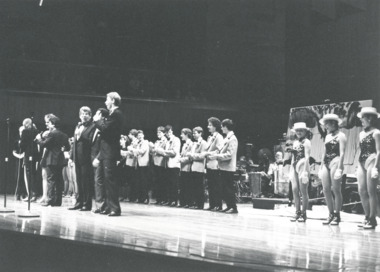
Photograph, A Legacy Night to Remember, charity concert 1985, 1985
These are photos of a Melbourne Legacy charity concert, which is possibly it is the concert in September 1985. Photos of singers and performers during the concert also guests and some performers afterwards. According to a programme stored at 00056, 'A Legacy Night to Remember' concert was at Melbourne Concert Hall, some of the performers were Barry Crocker, Simon Gallaher, Rolf Harris, Anne & Johnny Hawker's Band, Colleen Hewett, Jackie Love, Paul Martelle, 3rd Military District 'Redcoats'. Special guest compere - Daryl Somers. One of the photos show a lady holding a programme saying 'National Australia Bank proudly supports The Melbourne Legacy Charity Concert' - so it might be a different concert but the same performers are present. 01412.6 shows Legatee J C Dean who was president in 1984. The photos came from a Legacy envelope marked "P3 Fund Raising" in red pen, with assorted photos of fundraising events, including appeal tins in different years and a charity concert, and a fundraising marathon run (some are items 00433 to 00438, 01410 to 01415).A record of a Legacy run event for fundraising in either 1984 or 1985.Black and white photo x 6 of a charity concert for Legacy and 3 proof sheets.Proof sheets are labelled 'Cassidy and Baker, 226 Coventry St, South Melbourne, 699 4000 / Neg: ' The negative numbers are '4663', 4664' and '4665'fundraising, concert, gala performance -
 Melbourne Legacy
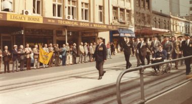
Photograph, Vietnam Veterans March in 1988, 1988
It was at the first international reunion of Vietnam Veterans held in Melbourne, in October 1988. It included a march down Swanston St to the Shrine. There are more photos of Legatees outside Legacy House watching the veterans march past at 01579 and 01380. The 1988 parade of Vietnam Veterans in Melbourne was a significant event and Legacy provided rosemary sprigs for the event, a meal afterwards and Legatees attended. Other photos had a label which said 'The first international reunion of Vietnam Veterans was held in Melbourne in October 1988. Many of Melbourne Legacy's 'Legatees' stood to salute the marchers as they made their way to the Shrine of Remembrance.' Views of Swanston St streetscape in the background, including corner of Lonsdale and Swanston St looking south to the Shrine. Street banners said 'Remember' on a green and red background.The 1988 parade of Vietnam Veterans in Melbourne was a significant event and Legacy provided rosemary sprigs for the event, a meal afterwards and Legatees attended.Colour photo x 10 of a Vietnam Veterans march past Legacy House and a white paper label.White paper label handwritten in black 'Vietnam Veterans International Reunion. Melbourne Legatees salute Vietnam Vets.' Photos were taken by Susie Howard the publicity officer, and the date was 15.10.88.vietnam veterans, march, legatee event, streetscape -
 Ballarat Tramway Museum
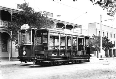
Photograph - Geelong Tramway "Summer Car"
"Summer Car" 11 outside Mac's Hotel in Corio Tce. To the right is Strachan, Murray and Shannon's wool store whose facade still stands. The tramcar, shown in pristine condition was one of the two trailers motorised in 1913 with equipment identical to that of the Duncan & Fraser cars. They were built for use mainly on the new South route to the Barwon River. The coloured destination lights were from left: Red for GEELONG WEST, blank (later blue for the East route), white for SOUTH GEELONG and green for NEWTOWN. Side destination boxes have been added. Late 1913.Black and white print on paperNo. 1 inside a circle, and 13-7 written in ink on reverse. GSR7109/13/1/7 written on reverse in pencil.geelong tramway summer car 11, geelong streetscape, geelong tramway motorised trailer, geelong tram destination lights -
 St Kilda Historical Society
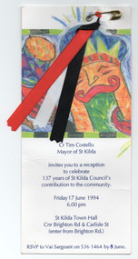
Ephemera - Invitation, Reception to celebrate 137 years of St Kilda Council's contribution to the community, 1994
Invitation from St Kilda Mayor Tim Costello to a reception to celebrate 137 years of the St Kilda Council shortly before the City of St Kilda was amalgamated with parts of the City of South Melbourne, most of the City of Port Melbourne, and a small portion of Windsor from the former City of Prahran, to form the City of Port Phillip.White card printed in dark blue, with multicoloured image. Red, black and white ribbons attached with silver safety pin.'Don Taggart' written on back of cardcity of st kilda, st kilda council, st kilda mayor tim costello