Showing 440 items
matching victoria hill area
-
 Bendigo Historical Society Inc.
Map - DEPARTMENT OF MINES VICTORIA : PLAN SHOWING PORTION OF THE BENDIGO GOLD FIELD
Department of Mines Victoria. Plan showing portion of the Bendigo Gold Field. On the back is written, in ink, J. J. Tyler 1937 Northern Area. (He was a teacher at Bendigo High - see donation notes). Across the bottom of the map is written ' M. Hill cr. Myrtle & Barnard' .The named reef lines have been numbered with ink across the bottom of the map. The gullies have been coloured with green pencil and a red pencil line is drawn through the western side of the map. Additional information: anticlinal axial lines at surface, alluvial workings, shaft sites, area of Main Goldfield, Deepest mine workings, Gold output of field to 1935, and Dividends paid 1870 - 1935.bendigo, gold mining, bendigo gold field. gold mining. tyler, j. j. -
 Eltham District Historical Society Inc
Photograph - Digital Photograph, Alan King, Panton Hill Primary School, 27 March 2008
The Panton Hill Primary School building, which has served the community since 1889, was not the area's first. Kingston School (an early name for Panton Hill) opened in May 1865. This was replaced in 1871 when the Panton Hill School number 1134 opened and in 1874 the school moved to its current location [September 2023] where many additions and renovations have taken place to meet the needs of local children in the 21st century. Covered under Heritage Overlay, Nillumbik Planning Scheme. Published: Nillumbik Now and Then / Marguerite Marshall 2008; photographs Alan King with Marguerite Marshall.; p63 The Panton Hill Primary School building, which has served the community since 1889, was not the area’s first. In 1871 Henry Edelman opened a Common School in a paling-clad hut, replacing the Kingstown No 786 school. The two-acre (0.8ha) site of crown land had previously been held under Miners Right. In 1875 the Education Department bought a building on the main road for State School No 1134, for £200 and remodelled it as a school.4 Panton Hill had as one of its teachers, Frank Tate, who was to become one of Victoria’s most influential educational reformers. It was his first school, when he began teaching on January 22, 1884, as a 20 year old.5 The following month Robert J Harris was appointed to the school and remained as head teacher until his death in 1887. His son R C Harris was apprenticed to Mr Rossiter, editor of the first local paper. The Evelyn Observer, first published in 1873. Harris later bought the newspaper which remained a family business until the 1920s. J Hughes of Cherry Tree Road succeeded Harris as teacher at Panton Hill and sold his land for the school site. Though now unrecognisable, the school building includes the classroom of the last Smiths Gully State School No 1737, which was built in 1882, and moved to Panton Hill in 1894. From 1922 each school day began with the ringing of the bell, which is still in its stand, and is an unusually old memorial of this kind. To accommodate the growing population, the building was remodelled, with additions in 1923 and classrooms were added in 1955, 1963 and 1970. The former teacher’s residence is the only surviving 19th century dwelling in the centre of Panton Hill, and is now used as part of the school. The residence was originally rectangular but is now L-shaped. Similar weatherboard State School buildings in the shire from this period are the Kangaroo Ground and the St Andrews Primary Schools. All were standard Education Department/Public Works Department designs.This collection of almost 130 photos about places and people within the Shire of Nillumbik, an urban and rural municipality in Melbourne's north, contributes to an understanding of the history of the Shire. Published in 2008 immediately prior to the Black Saturday bushfires of February 7, 2009, it documents sites that were impacted, and in some cases destroyed by the fires. It includes photographs taken especially for the publication, creating a unique time capsule representing the Shire in the early 21st century. It remains the most recent comprehenesive publication devoted to the Shire's history connecting local residents to the past. nillumbik now and then (marshall-king) collection, panton hill primary school -
 Eltham District Historical Society Inc
Photograph - Digital Photograph, Alan King, St Matthew's Church and Hall, Panton Hill, 27 March 2008
St. Matthew's Church has historic significance as the town's church and physical and social focus for the community. The standard design buildings are good examples and important streetscape elements. The war memorial cross is the area's monument to the 20th century wars and its modest scale in comparison with the granite Eltham and towered Kangaroo Ground memorials illustrates the lack of affluence in the town and surrounding area. The grouping of church, school, store and post office is typical of country villages throughout Victoria. The Radiata Pine plantings are significant as an intact line of shelterbelt planting typical of the early 20th century. (Bick Study 1992) Covered under Heritage Overlay, Nillumbik Planning Scheme. Published: Nillumbik Now and Then / Marguerite Marshall 2008; photographs Alan King with Marguerite Marshall.; p63 Panton Hill’s first church services were held in a simple building made of paling timber, opposite the Hotel de France. The building was also used for Sunday School, a school and a hall.1 The St Matthew’s Church and hall at the corner of Church Road and Kangaroo Ground-St Andrews Road, were built in the early 20th century in the standard rectangular style of the times. The intact belt of Radiata Pines was common at that time. The war memorial concrete cross is the area’s monument for the 20th century wars. It is much more modest than those in Eltham, and particularly in Kangaroo Ground, demonstrating those townships’ comparative affluence.2 Early settler J Hughes, who donated the land to the Church of England, was the first to be married at St Matthews when he married Rachel Coutie. In later life he became a minister of religion.3 One much-liked preacher was George Hollow, who with his sister playing the harmonium, conducted church services at Panton Hill, St Andrews and Christmas Hills, for many years.This collection of almost 130 photos about places and people within the Shire of Nillumbik, an urban and rural municipality in Melbourne's north, contributes to an understanding of the history of the Shire. Published in 2008 immediately prior to the Black Saturday bushfires of February 7, 2009, it documents sites that were impacted, and in some cases destroyed by the fires. It includes photographs taken especially for the publication, creating a unique time capsule representing the Shire in the early 21st century. It remains the most recent comprehenesive publication devoted to the Shire's history connecting local residents to the past. nillumbik now and then (marshall-king) collection, panton hill, st matthew's church, panton hill war memorial -
 The Beechworth Burke Museum
Geological specimen - Sphalerite, Unknown
Sphalerite or sphaelerite is named from the Greek word for 'treacherous' or 'deceiver' as specimens can vary widely in appearance, making them hard to visually identify. It is a zinc sulfide with the chemical composition (Zn,Fe)S, the most important ore of zinc. Specimens of sphalerite can contain iron as a substitute for up to 25% of the usual zinc present, as well as trace elements of gallium, cadmium, geranium and indium. Small amounts of arsenic and manganese may also be detected. Sphalerite is found in igneous, sedimentary and metamorphic rocks. It forms when carbonate rock encounters acidic, zinc-bearing fluid. It often forms in veins or in fissures of the existing rock, with colours and crystal shapes dependent on the composition of the the combining elements. It forms isometric crystal shapes including cubes, tetrahedrons, octahedrons, dodecahedrons. This specimen was collected in approximately 1852, in Broken Hill, NSW, as an adjunct to the Geological Survey of Victoria. It was donated to the Museum in 1868. Victoria and other regions of Australia were surveyed for sites of potential mineral wealth throughout the 19th Century. The identification of sites containing valuable commodities such as gold, iron ore and gemstones in a locality had the potential to shape the development and history of communities and industries in the area. The discovery of gold in Victoria, for instance, had a significant influence on the development of the area now known as 'the goldfields', including Beechworth; the city of Melbourne and Victoria as a whole.The specimen is significant as an examples of surveying activity undertaken to assess and direct the development of the mineral resource industries in Victoria and Australia, as well as the movement to expand human knowledge of earth sciences such as mineralogy and geology in the nineteenth century.A pipe-shaped specimen of sulfide-mineral zinc ore displaying patches of black, brown, beige and gold colouring. The main item has associated broken pieces. geological specimen, geology, geology collection, burke museum, beechworth, mineralogy, indigo shire, geological survey, sphalerite, sphaelerite, zinc ore, broken hill, nsw, victoria, galena, fluorite, chalcopyrite, lead, cadmium, gallium, germanium, indium, iron -
 University of Melbourne, Burnley Campus Archives
Certificate - Award Certificate, Ruth Waters et al, Royal Horticultural School, Burnley, Department of Agriculture Victoria Diploma, c. 1891
1. 18 unused coloured Diploma Certificates of the type used in c. 1891. Royal Horticultural School Burnley Department of Agriculture, Victoria. 2. Includes a drawing, a copy of the coloured areas of the 'Pavillion Print' made by Ruth Waters, 2 Jackson Avenue, Box Hill, in 1991. diploma, certificate, pavillion print, ruth waters, original diploma certificate, drawing -
 Linton and District Historical Society Inc
Photograph, Electro Hydraulic Dredge, Snake Valley, 1909
Electro hydraulic dredge Snake Valley 1909. J Mc Bennett, was an engineer back at the main base, at Dawson's dam on the Carngham Road, Between Linton and Snake Valley. These dredges were used for getting gold. The streams of water under high pressure just washed the hills and ground away. This dredge closed down early 1910. 200 H.P. motors were used and 10 in. pumps.Black and white image of three workmen, one beside mining building the other two at dredge pump outlet. Image mounted on dark brown card. Between 1904 and 1911 the Electro Hydraulic Company sought to extract gold in an area north of Linton known as the Hard Hills. By blasting water from high-pressure hoses into the hillsides, soil containing gold was washed out for sluicing. Two gravel pumps in Dawson's Dam pumped the wash through the sluices. Despite considerable investment in expensive equipment, the Company did not have a great deal of success, and the mining operation ceased in 1911.mining, gold, mining equipment, electro hydraulic dredge, dredging, sluicing, dawson's dam, snake valley, miners -
 Flagstaff Hill Maritime Museum and Village
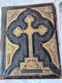
Book - Bible, Thomas Kelly & Sons, The Holy Bible - Douay Bible and Rheims Testament, 1880
The Douay (Douai) Rheims Bible is an English translation of the Latin Vulgate Bible (which had been the Latin Bible used by the Catholic Church since the 4th century). It was produced by Roman Catholic scholars in exile from Elizabethan Protestant England at the English College of Douai (then in the Spanish Netherlands but later part of France). The New Testament translation was published in 1582 at Rheims where the English College had temporarily located in 1578. The Old Testament was translated shortly afterwards but was not published until 1609-1610 in Douay (which makes it older than the King James version). The completed work was the only authorized Bible in English for Roman Catholics until the 20th Century. Its purpose was to uphold the Catholic tradition in the face of the Protestant Reformation and was produced as an alternative to the several Protestant translations then in existence. Prior to it being published, the Roman Catholic practice had restricted personal use of the Bible, in the Latin Vulgate, to the clergy. Bishop Richard Challoner issued a series of revisions (1749 - 1772) intended to make the translation more easily understandable and subsequent editions (including this one) were based upon this revision. In 1871, an edition of the Douay - Rheims Bible was published by Thomas Kelly & Sons of Philadelphia (and later, New York). Thomas Kelly described himself as a "Publisher, Printer, Binder, Lithographer and Steel Plate Engraver". In 1876, Thomas Kelly won an award (a Diploma of Honor and a Medal of Merit) for "the Best Catholic Bibles and Prayer Books" at the International Centennial Exhibition held in Philadelphia and his firm continued to print editions of the Bible throughout the 1870's but little is known of him after 1880 when this edition was published. This Bible has been in the Kermond family from 1888 until 1984 when Laurence Kermond (its last owner) died. The Kermonds were an old Warrnambool family with ties to the district going back to the mid 1840's. Joseph Kermond's mother, Catherine (1818 - 1895) and her husband John Kermond,, an ex-convict (1809 - 1877), had moved from Tasmania around 1843 and were living in the Warrnambool area in 1844 where their eldest son was born. They had six more children born at Port Fairy (or Belfast as it was then called). Catherine is buried at the Tower Hill cemetery. The last owner of the Bible was Laurence Kermond (1918 - 1984). He was the great grandson of John and Catherine Kermond and was a well known painter who lived in the Merimbula and Paynesville areas of N.S. W. and Victoria during the 1970's and early 1980's. The story of Joseph Kermond finding the Bible on a beach on the Shipwreck Coast near Peterborough on the southern coast of Victoria, Australia is plausible as it was not uncommon for items from shipwrecks to be washed ashore. However this Bible would not have come from the wreck of the Loch Ard as the dates don't align. The Loch Ard was wrecked in 1878 and this Bible was printed in 1880. It appears to have been printed for the Australian market as there is a page (with an engraved portrait) dedicated to the "Most Rev. Roger Bede Vaughan, O. S. B. Archbishop of Sydney, N. S. W.". It may also have been aimed at the Irish immigrants as the four "Family Register" pages are decorated with borders of shamrocks. The donor found the Bible in a box of secondhand books on a market stall in Gippsland and recognised its links to the Shipwreck Coast through the name of previous owners (a well-known Warrnambool name) and the story of it being found on a beach near Peterborough. This Bible is a rare example of Douay and Reims Catholic Bible of the late 19th century that was once a treasured item belonging to the Kermond family - one of Warrnambool's early settlers. It also has a most unusual story attached to it - being found (and rescued) washed up on a local beach and almost one hundred years later, being rescued again from a secondhand book stall.This Catholic Bible is an 1880 edition of a "Douay Bible and Rheims Testament", printed and published by Thomas Kelly of New York. Its full title is "The Holy Bible translated from the Latin Vulgate Diligently Compared with The Hebrew, Greek and Other Editions in Various Languages". It is revised with annotations by the Right Rev. R. Challoner D.D. The Bible has brown leather embossed front and back covers decorated with identical ornate gilt patterns and a central picture of a cross. It has two coloured illustrations and numerous black and white lithographs and engravings including portraits of past popes, events and places from Bible stories and decorative borders. The Bible includes the Old and New Testaments, approbations from Pope Pius the Sixth and Archbishops of the United States and other countries (including Archbishop Vaughan of Sydney), a Family Register with handwritten notes on births, deaths and marriages from the Kermond family (as well as a description of how they obtained the bible), a Catholic dictionary of the Bible, a history of the Holy Scriptures, a chronological list of heretics (Theological history) and a description of the "Centennial Award - Diploma of Honor and medal of Merit" won by Thomas Kelly (for the "Best Catholic Bible") at the Centennial Exhibition at Philadelphia in 1876. The Records section has a note on the Memoranda page written by William John Kennard in 1920.Spine: HOLY BIBLE Title Page: THE/ HOLY BIBLE /TRANSLATED FROM/ THE LATIN VULGATE/ DILIGENTLY COMPARED WITH/THE HEBREW, GREEK AND OTHER EDITIONS/ IN VARIOUS LANGUAGES/ THE OLD TESTAMENT WAS FIRST PUBLISHED BY THE ENGLISH COLLEGE AT DOUAY, A.D. 1600 / AND THE NEW TESTAMENT, BY THE ENGLISH COLLEGE AT RHEIMS, A.D. 1582./ REVISED WITH ANNOTATIONS/ BY THE RIGHT REV. R. CHALLONER D.D./ TOGETHER WITH REFERENCES, AND AN HISTORICAL AND CHRONOLOGICAL INDEX./ NOW CAREFULLY CORRECTED ACCORDING TO THE CLEMENTINE EDITION OF THE SCRIPTURES/ NEW YORK / THOMAS KELLY, PUBLISHER/ 17 BARCLAY STREET. / 1880 Dedication Page: DEDICATION OF THE ORIGINAL EDITION/ TO/ THAT LOYAL, RELIGIOUS AND ENLIGHTENED BODY OF MEN / THE/ CATHOLICS OF THE UNITED STATES OF AMERICA/ IN ADMIRATION OF THE STEADY ZEAL WITH WHICH THEY HAVE KEPTTHE/DEPOSIT OF FAITH/ BEQUEATHED THEM BY THEIR FOREFATHERS/ AND HANDED DOWN, WITHOUT INTERRUPTION OT ADULTERATION, TO THEIR GRATEFUL POSTERITY/ THIS EDITION/ OF THE/DOUAY BIBLE AND RHEIMS TESTAMENT/ IS / WITH GRATITUDE FOR PAST FAVORS AND HOPES OF FUTURE ENCOURAGEMENT/ MOST RESPECTFULLY ENSCRIBED. Handwritten note: ""This Holy Book was found . on the beach . near Peterborough Vic. having been washed ashore . from the wreck of the Loch Ard, (sailing ship) in the year 1888 . By .Joseph . Kermond; and presented to . his mother . Catherine Kermond , who in turn passed it - on . to her youngest . son ; one Jacob Kermond. He in turn presented . it to his son . William John Kermond , (the writer), 23/3/20)" [Original punctuation]flagstaff hill maritime museum and village, warrnambool, shipwreck coast, peterborough, kermond, kermond family, loch ard, bible, douay and rheims bible, catholic bible, thomas kelly and sons publiisher, douai, rheims, holy bible, religious bible, catherine kermond, john kermond, william john kermond' -
 Bendigo Historical Society Inc.
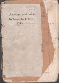
Booklet - Albert Richardson Collection: Bendigo Goldfield, MInes Department, Victoria 1936, 1936
Albert Richardson was an expert on the history of the Bendigo Goldfield. The Albert Richardson Park at Victoria Hill, is named in his honour. He was a prominent member of the Bendigo Historical Society. Fifty one page booklet. On front page: Bendigo Goldfield, issued by Geo Brown, Secretary for Mines, under the authority of The Hon. E.J. Hogan, M.L.A., Minister of Mines. Mines Department, Melbourne, Victoria, Australia, 1936.Content includes: historical information; recent development and future prospects, geology and lines of reef. Reef lines described are: Tysons, Lightning Hill, Hustlers, Derby, Paddy's Gully, Garden Gully, Deborah, Sheepshead, New Chum, Nell Gwynne, British and Foreign, Napoleon, Lancashire, Carshalton, Thistle, Christmas and Birds. On front cover 'Bendigo Goldfield, Geo Brown, Sec. for Mines, 1936' written in black pen. On first page 'A.Richardson, 29 Harrison Street, Bendigo' The booklet is annotated throughout by Albert Richardson, for example, the mines along the New Chum Line are further described with their date of formation, sill heights and area of claim.albert richardson, gold mining, goldfield, reef lines, 1936 -
 Bendigo Historical Society Inc.
Document - Hustlers, Sheepshead and Deborah lines of reef
Albert Richardson was a mining historian who wrote widely on the mines of the Bendigo Goldfield. The park opposite the Goldmines Hotel in Marong Road, is named in his honour. Five page document, hand written by Albert Richardson on lined foolscap and edited with cross-outs and insertions, . The mines along the Hustlers line of reef and the Sheepshead line of reef are described. Mines listed on Hustlers line of reef: Fortuna Hustlers (1888 - 1913), shaft 2,240 feet at rear of Buckell and Jeffrey's offices; Royal Hustlers Reserve No. 2 - two shafts 'City" 860 feet, now covered by R.S.L. building Pall Mall, steel poppet legs 60 ft high and 'Park Shaft" at rear of Camp Hill School, 1,775 feet, steel poppet legs 60 feet high; Hustlers Hill Group first worked by Jonathan Harris in 1853 and bounded by Valentine, Anderson and Ironbark Creek to the north and Milroy Street to the east, one of first areas worked for quartz reefing. It with Garden Gully line west and Victoria Hill Ironbark, formed by far the richest cross section of the Bendigo Goldfield. Great Extended Hustlers (1865-1921) close to intersection of Anderson Street and Hustlers Road, mullock heap against road and shored up around shaft, steel poppet legs now at Wattle Gully mine, Chewton, large winding machine, air compressor south of shaft and 36 head crushing battery. Hustlers Reef (Old Hustlers) and Hustlers Reef No. 1, two shafts, main 2,210 feet, about 220 yards east of Moran Street and against Fenton Street. , No. 1 shaft 1,140 feet and about 155 yards east of Moran Street. Lansell's Comet, Lightining Hill line, 2.100 feet, on Comet Hill approx 70 yards west of Holmes Road, near Comet Creek, steel poppet legs. United Hustlers and Redan (1876-1918), main Redan, 1,830 feet about 155 yards west of Sandhurst Roead, in line with Comet Hill State School, this hill known as Redan Hill. North, or New Hustlers, once known as Agnew Hustlers, wooden poppet legs, south side, Kneebone Street, Eaglehawk. Derby line, Johnson's No. 3, South Johnson's (east shaft of Collman and Tacchi) 439 feet on west wide of Woods Street, south of Wetherall Street. Paddy's Gully Line, south to north, some shafts - Lansell's 'Sandhurst" ('Needle") Eaglehawk Road shaft 2,425 feet, about 50 yards east of Needle Loops, a brick square sided chimney with Cleopatra Needle top. British American, 789 feet, just south of Holdsworth Road. Collman and Tacchi, main shaft 2,588 feet, 60 yards west of Eaglehawk Road, California Gully. Deborah Line of Reef, The Deborah (1932-1954) shaft 2.017 feet, west of Adams Road and south of Abel Street, Quarry Hill. North Deborah (1937 - 1954) shaft 1,151 feet, Breen Street, Quarry Hill, steel poppet legs. Central Deborah (1939-1954) shaft 1,347 feet Sheepshead line of reef, Lansell's South Red, White and Blue, shaft 2,124 feet, north east of Bellevue Road and 220 yards east of Adams Road. The New Red, White and Blue Consolidated (Big Blue) main shaft 2,416 feet. Lansell's Bendigo Battery 105 head, north of 'Big Blue" on his freehold lease, commenced crushing on 24th February 1895. After closing was erected as the Showground's Industrial Hall, July 1926. North Red, White and Blue, burnt down February 1926, new company 1934, closed 1938. Document is part of the Albert Richardson Collection of Bendigo mining history. bendigo, gold mining, deborah line of reef, sheepshead line of reef, hustlers line of reef, royal hustlers reserve mine, hustlers hill group of mines, great extended hustlers, hustlers reef no. 1, lightning hill line, old comet, collman and tacchi, lansell's comet, north deborah, central deborah, dhrrpdhrsf linr og trrg, new red, white and blue consolidated mine, big blue, lansell's bendigo battery, north red, white and blue mine, albert richardson collection -
![Painting - Watercolour, Mitchell, John, [Scottish Scene] by John Mitchell](/media/collectors/530576742162ef0fa09a2288/items/534748159821f420f8c036b5/item-media/534f6bb72162ef12d4dd1a07/item-fit-380x285.jpg) Federation University Art Collection
Federation University Art CollectionPainting - Watercolour, Mitchell, John, [Scottish Scene] by John Mitchell
John MITCHELL (1837 - 14 July 1926) Born Woodside, Donside, Scotland John Mitchell attended evening classes under James Giles in Aberdeen, and was also taught by his uncle the Peterhead artist John Mitchell. After an apprenticeship at a local lithographic company (Keith and Gibb) John Mitchell went to London to study at the Slade under Legros. Returning to Aberdeen he painted many scenes around the city and Aberdeenshire, including Balmoral, under the patronage of Queen Victoria. John Mitchell gave lessons in painting to the Royal Family. His landscapes are highly coloured with dominant blues and purples in the hills and with vivid greens and yellows in the foreground, subtly fused and never garish. He lithographed sketches for John Stewart's 'The Sculptured Stones of Scotland', 2 vols 1856-57, illustrated 'Under Lochnagar' 1894. His landscapes of Aberdeenshire are highly prized especially in the area in which he lived. His painting in the Mearns is regarded by some as his best work. In 1875 he painted an interior of Culter Castle and its Chapel which was subsequently purchased by the owner and in 1883 showed a portrait of his mother. Lived latterly at 10 Gladstone Place, Queen's Cross, Aberdeen. This item is part of the Federation University Art Collection. The Art Collection features over 2000 works and was listed as a 'Ballarat Treasure' in 2007.Framed watercolour of a Scottish Scene by John Mitchellart, artwork, john mitchell, mitchell, scotland, scottish, art, artwork, john mitchell, mitchell, scotland, scottish -
 Federation University Art Collection
Painting - Watercolour, Mitchell, John, [Scottish Scene], 1981
John MITCHELL (1837 - 14 July 1926) Born Woodside, Donside, Scotland John Mitchell attended evening classes under James Giles in Aberdeen, and was also taught by his uncle the Peterhead artist John Mitchell. After an apprenticeship at a local lithographic company (Keith and Gibb) John Mitchell went to London to study at the Slade under Legros. Returning to Aberdeen he painted many scenes around the city and Aberdeenshire, including Balmoral, under the patronage of Queen Victoria. John Mitchell gave lessons in painting to the Royal Family. His landscapes are highly coloured with dominant blues and purples in the hills and with vivid greens and yellows in the foreground, subtly fused and never garish. He lithographed sketches for John Stewart's 'The Sculptured Stones of Scotland', 2 vols 1856-57, illustrated 'Under Lochnagar' 1894. His landscapes of Aberdeenshire are highly prized especially in the area in which he lived. His painting in the Mearns is regarded by some as his best work. In 1875 he painted an interior of Culter Castle and its Chapel which was subsequently purchased by the owner and in 1883 showed a portrait of his mother. Lived latterly at 10 Gladstone Place, Queen's Cross, Aberdeen. This item is part of the Federation University Art Collection. The Art Collection features over 2000 works and was listed as a 'Ballarat Treasure' in 2007.Framed watercolour of a creek in Scotland.art, artwork, art, artwork, john mitchell, mitchell, scotland, scottish -
 Flagstaff Hill Maritime Museum and Village
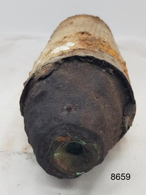
Weapon - Ammunition Shell, Late 19th-early 20th century
Ammunition shell was used in a 40 lb Armstrong Rifled Breach Loading (RBL) Gun. It does not contain explosives because the projectile and explosive were separate items. The Armstrong 40 lb BL Gun There were 4 x 40lb Armstrong (RBL) Guns issued to the Ham and Beef Battery at Hastings Victoria. After the Hastings Battery field artillery disbanded, the 4 Guns were transferred from the Hastings Battery to the Warrnambool Battery field artillery in 1904. (There is a photograph of one of these guns on its carriage, pictured in front of the Orderly room (Drill Hall) at Warrnambool, which is now the Library of South West TAFE). The 40lb Armstrong Guns were recalled back to Melbourne when the government issued the updated 4.7inch QF (Quick Firing) Naval Guns, mounted on carriages, to the Warrnambool Garrison Artillery 1907. The Hastings Museum today holds one of the original 40lb Armstrong RBL guns that were at first at Hastings and then Warrnambool, evidenced by tracing the numbers on that gun. This gun has now been restored. Surviving 40 lb Armstrong BL Guns in Australia The Hastings Museum has restored one of the Guns that was at Hastings and then from 1904-1907 in Warrnambool. This Gun is now on display at the Hastings Museum.This ammunition shell from a 40lb Armstrong RBL gun is very significant because of its association with the Warrnambool Battery Field Artillery in the early 1904-1907. It is known that the original 40lb Armstrong RBL gun used in Warrnambool is now restored and on display at the Hastings Museum.Ammunition shell from a 40Ib Armstrong Rifled Breach loading (RBL) Gun. Metal bullet-shaped object, flat base, tapering to cone-shaped tip. Parallel equidistant ridges run from outer edge of base to position where cone shape begins. Tip has a square-shaped hole in the centre and has a very uneven surface. Base has corrosion and metal is flaking away. Does not contain explosives. Remnants of white paint-like substance in several places. From the Hastings, Victoria, area. Late 19th - early 20th century.flagstaff hill maritime museum and village, great ocean road, shipwreck coast, ammunition shell, 40 lb, war equipment, hasting battery field, defence of warrnambool -
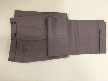 Warrnambool and District Historical Society Inc.
Pants, Fletcher Jones, Mid 20th century
These trousers have been made by Fletcher Jones and Staff. This business was established by David Fletcher Jones (1895-1977) in 1924 when he leased three shops in Liebig Street, Warrnambool. In 1928 he moved his business to the main retailing area near the Liebig Street/Koroit Street intersection. In 1931 a shop built to Fletcher Jones’ requirements was erected and by 1938 he had a staff of 40. By 1945 FJ trousers were sold in 123 stores in Victoria and in 1948 the Fletcher Jones factory was established in Flaxman Street Warrnambool, officially named Pleasant Hill. In 1951 the company became Fletcher Jones and Staff and by the mid 1970s the staff had 75% ownership. By this time FJ and Staff had become one of the largest clothing manufacturers in Australia with 55 shops and almost 3000 employees. The range of clothing was enlarged to include both men’s and women’s wear. In the 1980s, after the death of Fletcher Jones, the abolition of import tariffs and the availability of cheap imported clothing caused the Fletcher Jones Company to decline and to be sold to a Geelong company. By 2011 all Fletcher Jones shops had closed. These trousers are of great interest as they are a product of a Warrnambool business that was nationally and internationally known in the 20th century for its quality men’s wear, especially the Coverdine brand trousers. The Fletcher Jones business remains one of the most important businesses, (if not the most important), that ever existed in Warrnambool. It employed a great number of local people in the second half of the 20th century, and is remembered with great fondness by many people in the city and surrounds today. The Fletcher Jones Gardens at the Factory site are still maintained today and are a tourist attraction in the city. These are a pair of brown Fletcher Jones trousers made of Coverdine material (87.5% wool with nylon). There is some lining around the waist area and the legs are turned up at the end with some leather binding inside the bottom legs. The waist band is stiffened and is fastened with a metal clip and two buttons. The waist band has two adjustable areas using tabs and two buttons each side. The back pockets also have buttons.fletcher jones and staff, coverdine fletcher jones trousers, history of warrnambool, david fletcher jones -
 Clunes Museum
Book, WESTON ARTHUR BATE, LUCKY CITY - THE FIRST GENERATION AT BALLARAT: 1851 - 1901
IN 1854, ATTRACTED TO THE AREA BY WORLD FAMOUS GOLD DISCOVERIES, A EUROPEAN ARTIST SKETCHED AND ABORIGINAL AT WORK I THE FOREST AT WARRENHEIP NEAR BALLARAT...GREEN FABRIC COVER WITH GOLD LETTERING ON SPINE, COMPLETE WITH DUST COVER WHICH DISPLAYS A COLOURED ENGRAVING OF NINE PEOPLE IN A LANDSCAPE OF HILLS AND STREETSCAPE IN THE DISTANCE (AN ILLUSTRATION OF BALLARAT FROM BLACK HILL) non-fictionIN 1854, ATTRACTED TO THE AREA BY WORLD FAMOUS GOLD DISCOVERIES, A EUROPEAN ARTIST SKETCHED AND ABORIGINAL AT WORK I THE FOREST AT WARRENHEIP NEAR BALLARAT...the first generation of ballarat 1851-1901, gold fields of central victoria -
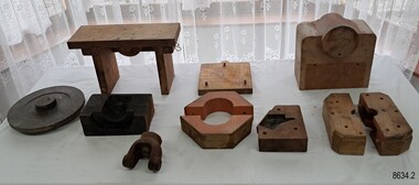 Flagstaff Hill Maritime Museum and Village
Equipment - Foundry Patterns set, Briggs Brass Foundry, Early 20th century
The wooden crate contains a set of patterns or moulds that were once used at Briggs’ Brass Foundry for making sand moulds. The traditional method of sand casting is over 2000 years old. It is part of a crafted process used to make brass and copper alloy goods suited to marine use; bells, boat hooks, cowls, propellers, handles, lids, rowlocks, hooks, letters, bolts, rail holders, brackets, deck plates, flanges, rudder guides, portholes and covers. Briggs’ Bronze is a copper-based alloy made from local ingots of copper, tin, zinc and lead in carefully measured quantities. The finished product is non-corrosive and can last indefinitely. The crate of patterns was donated by the Briggs family in the early years of Flagstaff Hill, along with other related items such as brassware, tools and machinery. The donated items were displayed in a simulated Brass Foundry in the Village. The items were on show from the completion of the building in 1986 until 1994 when the building was repurposed. The patterns represent the trades of foundering and metalwork, both supporting maritime industries such as shipwrights and boatbuilders. Farmers, manufacturers and other local industries also needed the castings made by foundries. The Brass Foundry display was one of the early ‘working craft’ shops at Flagstaff Hill. It included a historic Cornish chimney that was set up as a working model, telling the story of heat from furnaces to smelt metal, which would then be poured into the sand moulds. This chimney is made from specially curved bricks and is about two-thirds of its full height when originally located at the Grassmere Cheese factory. HISTORY of BRIGGS BRASS FOUNDRY: - The family business was founded in 1912 by Herbert Harrison Briggs (1963-1931) with his son George Edward Briggs, trading as Briggs & Son Foundry at 70 Wellington Street, Collingwood. Younger son Cyril Falkiner McKinnon Briggs joined the foundry in 1922, and it was renamed H H Briggs & Sons Foundry. Both sons ran the firm after Herbert’s death in 1931, making products mainly for marine purposes. They became Bell Founders in 1936 and were known for their specialty of high-quality ship bells. They produced miniature varieties of these and other decorative items such as small propellers. The firm became known as Briggs Marine Foundry. The great-granddaughter of Herbert Briggs inherited the Briggs Brass Bell, similar to the one at Flagstaff Hill. Cyril became the sole family member of the firm in 1965. The Briggs Marine was an exhibitor at the 1965 Boat Show, where he advertised as “non-ferrous founders” and “Bell Specialists”. The foundry relocated to Chesterville Rd, Moorabbin. Cyril passed away in 1967. It is thought that either Cyril or his business partner Frank Lee donated the objects from the Briggs’ Foundry around the time when the business moved to Moorabbin. However, Flagstaff Hill hadn’t been thought about until 1972. The donated items were registered in the Collection in 1986 but they could have been in storage from an earlier date. In October of that same year, Briggs Marine restored Schomberg Bell, a shipwreck artefact from the collection at Flagstaff Hill. Peter Oram, who had worked for the previous owners of Briggs Marine as a fitter and turner, took over the firm in 2014, reviving some of the old casts for current use. The business is now located at Seaford in Victoria and is part of Alliance Casting & Engineering Solutions (Alliance Casting Pty Ltd). In 2016 the original Collingwood Foundry building was repurposed as a thriving business hub named The Foundry. The crate and its patterns are significant for their association with brass foundries locally and generally in coastal areas of Victoria. Marine industries such as ship and boat building rely on good quality castings for their machinery, equipment and fittings. The patterns are associated with the long-running firm, Briggs Brass Foundry, that specialised in cast goods for the marine industry, ready to supply the needs for once-off or mass-produced items. Their products would have been fitted to sail and steam vessels along coastal Victoria including Warrnambool. Briggs Marine is also associated with the Schomberg Bell in Flagstaff Hill, restoring the bell to is former state to show an example of the bell from a luxury mid-19th century vessel. The craft of sand-casting from carved wooden patterns to create metal is an example of skills from the past that are still used today. Wooden rectangular crate with removable wooden lid. Inside is a set of wooden patterns of various shapes and sizes for making sand moulds in a metal foundry. The crate is made from thick wooden planks nailed together. The extended wooden struts on the long sides form a frame to hold the wooden lid. A pair of metal handles are at each short end of the crate, fixed with strong metal bolds. Between each pair of handles is an inscription stamped into the wood. The underside of the crate has red paint splashes. There are insect holes in the wood but no sign of current infestation. Stamped: "H.33 / II" (H may be N or a square B)flagstaff hill maritime museum and village, great ocean road, shipwreck coast, pattern, mould, foundry, brass foundry, metal foundry, crate, box, wooden container, briggs, traditional method, trade, sand cast, cast, brass alloy, copper alloy, marine equipment, marine tools, marine fittings, briggs' bronze, copper tin zinc lead, non-corrosive, briggs family, brassware, metalware, foundering, metalwork, maritime, casting, cornish chimney, curved bricks, grassmere cheese factory, 1912, herbert harrison briggs, h h briggs, george edward briggs, briggs & son foundry, collingwood, cyril falkiner mckinnon briggs, cyril briggs, h h briggs & sons foundry, bell founders, schomberg bell, alliance casting & engineering solutions, collingwood foundry, ship chandlers, marine products, flagstaff hill, warrnambool, maritime museum, maritime village, briggs & son brass foundry, briggs marine, moorabbin -
 Bendigo Historical Society Inc.
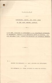
Document - MCCOLL, RANKIN AND STANISTREET COLLECTION: REPORT ON CASTLEMAINE, MALDON & OTHER AREAS
Copy of a typewritten report on Castlemaine, Maldon, and other areas of the main Bendigo District by H.W. Gepp Consultant on Development to the Commonwealth Government. W. Baragwanath Director of the Geological Survey of Victoria and F.L. Stillwell D.Sc. Council for Scientific and Industrial Research. Mentions Castlemaine, Fryertown, Maldon, South German Mine, Mt. Tarrengower Tunnel, Raywood, Sebastian, Wedderburn, Inglewood, Whipstick, Lightning Hill, Black Forest Mine, Old Tom Mine. Trentham. Dated 17th September 1931. Consists of 19 Foolscap PagesH.W. Gepp, W. Baragwanath, F.L. Stillwell.gold, mining, report, gold mining, bendigo, castlemaine, maldon -
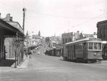 Ballarat Tramway Museum
Photograph - Tram 34 - Bakery Hill, Ken Winney, 12/1949
Photograph shows SEC Ballarat tram No. 34 climbing Bakery Hill in Victoria St. The photo is taken at Humpffray St looking west. There is a Grocer on the left hand side of the photo. Photo by I K Winney of Sydney, 12/1949.Yields information about the view looking west along Victoria St from Humpffray St during 1949.Black and white photograph with photographers details on rear."Bogie No. 34 (ex MMTB C class) en route to Victoria St. Ballarat city area in background. 12/1949, I K Winneytramcars, tram 34, victoria st, bakery hill -
 Flagstaff Hill Maritime Museum and Village
Photograph - Glass plate, circa 1866
This glass plate photograph shows good detail of members of the Warrnambool Garrison posing for their photograph in front of a young township. There are other well-dressed citizens behind them. The three men with frogging on their sleeves were commanders were likely to be commanders. The men are facing north with Cannon Hill and the fortification area in the background. It dates from the 1860s. The firearms held appear to be 1853 pattern Lee Enfield muskets used by the British army in Crimea at this time and in Australia, rather than the later Martini Henry cartridge rifles. The uniforms match other photos of the Warrnambool Garrison Militia and Band in our Collection, taken up until the 1880s. The three storey building in the photograph is likely to be the Manifold & Bostock flour mill, built in 1854 near the ‘cutting’ in Merri Street, which was one of the main streets at the time; if one faced the building’s front from a vantage point and looked south to south-east, the hills around Flagstaff Hill and Cannon Hill would be behind that mill, and the Harbour behind the hills. This is the area of the Fortifications. The glass plate method of photography was widely used during the mid-19th to early-20th century. The donor and maker of the photograph are unknown. Around this time the citizens of Victoria were prospering from the gold rush but felt isolated and uneasy about their security in the colony. In 1854 the Volunteer Act was passed to provide some military defence. In 1858 the Warrnambool Volunteer Rifle Corps was established, disbanded in 1863, then a new Warrnambool Detachment was formed in September 1866. Legislation was passed in 1884 that replaced the volunteers’ corps with a partly paid, permanent Militia Defence Force. The batteries manning the coastal forts of Victoria were termed Garrison Artillery Companies. When the Army was federated in 1901 there were eight Militia Companies in Victoria. Warrnambool and Port Fairy together were known as 8 Coy AGA (Australian Garrison Artillery). Changes to formation and name continued into the 20th century.This photograph is a record of the very early local defence force, circa 1866. The photograph signifies the connection of the colony in Victoria to the growing need for security due to the unrest in Europe at that time. The photograph is also locally significant to the industry of the young township of Warrnambool, showing what is likely to be one of the first flour mills in the town. The photograph is also the only example of the early methods of glass plate photography in our collection. Photograph, rectangular glass plate, positive sepia image. Photograph has brass framed edges that fold over to the back, with mitred corners. The front edges are pressed with a decorative floral pattern. The photograph shows a group of thirty military men, standing or kneeling, in dark uniforms with pillbox forage caps, round-collared jackets with light buttons, light sashes worn from top left shoulder to bottom right side of waist belt, and long, straight-legged trousers. Three of these men have light braid around the buttons on the front of their jackets, light frogging on their sleeve cuffs and stripes on the outside seams of their trousers. The other twenty-seven men have plain uniforms and are holding firearms in their right hands, steadied with their left hands. Other figures are standing behind this group of soldiers, including three or four men wearing top hats, jackets and ties. In the background is a row of buildings. The central building is three stories high. Bare hills are in the far background. The foreground is uneven ground with patches of short grass. Photographer looking towards the south east and Cannon Hill, with the Warrnambool Garrison facing north, ca.1860s.flagstaff hill, warrnambool, shipwrecked coast, flagstaff hill maritime museum, maritime museum, shipwreck coast, flagstaff hill maritime village, great ocean road, glass plate, photography 19th century, colonial forces, military defence, volunteer act 1854, volunteer rifle, garrison artillery, volunteer corps, militia, militia garrison band, pillbox forage caps, helpmann, manifold and bostock, 1853 lee enfield musket, tintype, warrnambool garrison, 1860s, cannon hill, manifold & bostock, flour mill, 3-storey building -
 Bendigo Historical Society Inc.
Document - MARKS COLLECTION: MAP OF EAGLEHAWK/LONG GULLY AREA
Map of Eaglehawk and Long Gully area. Maps shows allotments and areas. Map is split down centre (torn?) and in two pieces. Map was located in Fortuna papers, potentially belonged to G. Lansell. Section of map has been neatly cut out - area near Mt Korong Road and Victoria Hill.map, eaglehawk, long gully, marks collection -
 Ringwood and District Historical Society
Mixed media - Video, RDHS Meeting Presentation - "The Adventurous Life of R.H. (Bob) Croll" - Russ Haines
Digitised video (2.67GB). Duration: 58minutes. Recorded February, 2025 (Video is available for viewing at Ringwood & District Historical Society Archives by appointment)In this presentation, Ringwood and District Historical Society President Russ Haines provides a brief profile of Bob Croll, man of adventure, pioneer of amateur athletics in Victoria, a writer of collective note, an explorer of indigenous culture, as well as mixing with important artists, sculptors and authors of the pre-WW1 era. Bob shared his travels with eminent psychologist Stanley Porteus, the son of Ringwood Methodist David Porteus and his wife, Katherine, who attended Ringwood State School. Bob's walking adventures included following Canterbury Road up into the hills, through the Ringwood area of "heath" into the wonderful hamlets around Mount Dandenong. -
 Flagstaff Hill Maritime Museum and Village
Weapon - Historic Rifles, Royal Small Arms Factory, 1877-1900
Martini-Henry Artillery Carbin rifles were made by the Royal Small Arms Factory at Enfield, Britain, from 1877 until 1900. Many were distributed to the British Colonies, including this pair, which was allocated to the Woodford Police, Victoria Police District of Warrnambool, Southwest Victoria. The Carbine model rifles were shorter than the standard rifles and more suited to mounted police and troopers. It is likely that in the early 20th century, Victoria Police replaced the two carbines with more modern firearms, and the outdated guns were stored in the stables. The rifles were left there and likely forgotten about due to changes in police staff. In 1915, police authorities announced that they would be replacing patrol horses with bicycles and would also close some smaller police stations. This affected Woodford Police Station, which closed in 1917. The forgotten firearms remained in the stables and were noticed by schoolboy Robert Jellie in 1940 and seen again in 1946. In 1995, the property was sold by the Education Department to a private owner. The Woodford Community donated the pair of Martini-Henry Carbines to Victoria Police Museum in the late 1990s for mounting and display, which was funded by the Victoria Police Historical Society Inc. The decorative wood and glass display case and frame were designed to preserve the significant history of the guns. On November 1st 1999, the display was presented to Warrnambool Police and the local community due to the historical significance of the Woodford Police Station. On March 10th, 2025, the display was transferred to Flagstaff Hill Maritime Museum and Village, where the historical story of the Martini-Henry Carbines could continue to be preserved and accessed by local families, the community, visitors to the area, and online visitors. WOODFORD POLICE: - The small settlement at Woodford was established in the 1840s around the Merri River where there was a ford across the water and, from 1848-1851, a bridge. The area was settled very early in Victoria’s history and the river crossing provided travellers with access to the early route between Port Fairy (name Belfast at that time), Warrnambool and Melbourne. Occasionally a Warrnambool police trooper would ride through Woodford and district. In December 1854, Woodford Police barracks and stables were built on the hill by the Merri River on Bridge Road east where Jubilee Park now stands. A local mounted trooper kept law and order in the area. In 1856, a lock-up was installed, and the first Woodford Police Station was in action in 1857. By 1871, the police station had been moved from the hill to land across the Merri River bridge, on the southern side of Bridge Road west, near Mill Street. In 1890, the police residence there was replaced by a stone Edwardian-style building with the stables and lock-up behind it and the old police station at the rear. The police continued to have a presence in Woodford until it was closed by the Police Commissioner in July 1917 for economic reasons. The residence was used for government housing until 1923, when it was taken over by the Education Department for the school teacher’s home. In 1995, it became privately owned. THE MARTINI-HENRY ARTILLERY CARBINE: - The Martini-Henry rifles were made in Britain from 1871 at the Royal Small Arms factory at Enfield and were stamped with the symbol of the Royal Cipher (Crown over VR) over ENFIELD to identify their origin. They were named after two of several people who helped design this method: Swiss Friederich von Martini and Scotsman Alexander Henry. The design was breach-loaded, and the inner barrel was rifled. A thumb rest was incorporated into the top right of the bullet receiver’s chamber. The small teardrop lever on the right side of the rifle showed whether the rifle was ready to be shot. In 1877, the shorter, lighter weight Carbine version of the firearm was produced for mounted troops and artillery. Its official name was “Carbine, B.L., Rifled, Martini Hanry.” The bullets were slightly lighter in weight than those used for the longer rifle. The sight position was adjusted for the shorter gun, and wings were added to the sight on the tip, making it easier to slide the rifle back into a saddle bag. Some of the later Carbines also had leather sight covers screwed to the stock to prevent them from catching on the saddle bags. The Carbines had accessories available, such as barrel extensions with bayonets and swivels for adding slings. The Martini-Henry Carbine designs were later modified to fire the British .303 ammunition. Eventually, by 1900, the Martini-Henry Carbines were replaced by the Lee Enfield gun design. The pair of Martini-Henry Carbine firearms represents policing in the early pre-1900 days of colonial settlement; Woodford was one of the first townships settled in Victoria, and it had a police presence from 1854 until 1917. The rifles and display provide a historic connection between the location of Woodford and relatives and associates. The carbine rifles show a stage in the evolution of weapon design, adapted to suit mounted troops, and adding features to streamline use and storage. The ammunition was also improved during this progression. The carbines are important for their connection to policing law and order in a remote area. They are significant for their association with the township of Woodford, which was important to travel in the southwest Victoria district, providing access across a river for a road between Port Fairy and Melbourne, and later Warrnambool, and supplying food, goods and accommodation for the travellers. A pair of mounted rifles is mounted behind glass in a timer case, accompanied by a framed display of two photographs and an account of the rifles’ history. The case and display each have a horizontal board with a gently curved edge and carved decorations added. The identical firearms are British-made Martini Henry Carbine breach-loaded rifled guns, supplied by Britain to its Colonial troops from around 1877. The rifles are lever-action, single-shot .500 calibre weapons. They have a teardrop lever on their right side. They were used by Victoria Police mounted troops at the Woodford Police Station, Victoria. The black and white photographs were taken in 1946. The left photograph has a circled area; the right photograph is an enlarged view of the circled area, showing the Woodford Police Station in detail. The printed text is on textured paper with the Victoria Police watermark. It gives a summary of the rifle’s history. There is an inscription on the left photograph. Left photograph, handwritten in white pen: “WOODFORD” Document’s print: “During the late 1840s the small town of Woodford grew around the crossing of the Merri River on the Melbourne/Port Fairy Rad. Woodford was proclaimed a township in 1854 and a police quarters was established there in 1857. The police station remained until 1917 when it was closed and police service from then on was provided from Warrnambool. The building was then used as a school residence and is now privately owned. In !940 Robert JELLIE, then a schoolboy, observed two rifles mounted on the wall of the disused stable at the rear of the old police building. Following the devastating flood of 1946 (see photograph above) the rifles were again seen in the room next to the stable but were not seen again until the building was sold by the Education Department many years later. It was a recognition of the historical value of the rifles which led to their donation to the Warrnambool Police Complex. The rifles have been authenticated by the Victoria Police Armoury as being Victoria Police issue some time before 1900. The rifles are an identical pair of the famous British-made Martini Henry, a .500 inch calibre military weapon widely used by British Colonial troops. Victoria Police and the wider community of Warrnambool are indebted to the members of the Woodford community for their fine gesture in donating the rifles for mounting so that their historical importance can be preserved and they can be displayed for generations to come. This display was funded by the Victoria Police Historical Society Incorporated, and presented on the first day of November, 1999.”flagstaff hill maritime museum and village, great ocean road, shipwreck coast, martini henry, victoria police, woodford police station, rifle, carbine, display case, british, martini henry carbine, breech-loaded, rifled, colonial, single-shot, .500 calibre, weapon, gun, 1877, troops, mounted troops, merri river, victoria police woodford, victoria police warrnambool, victoria police melbourne, police quarters, robert jellie, school residence, stable, 1946 flood, victoria police armoury, identical pair, british colonial troops, victoria police historical society incorporated, woodford, bicycles, found by a schoolboy, edwardian-style building -
 Flagstaff Hill Maritime Museum and Village
Photograph - Historical, building, Late 19th to early 20th century
The black and white photograph depicts the Lady Bay Lighthouse Complex at Flagstaff Hill, Warrnambool. It was opened on this site in 1871. From left to right, the Chartroom (previously named the Store), Upper Lighthouse, Flagstaff, Lighthouse Keeper's Quarters. The bluestone buildings are facing North on Merri Street. The Harbour Pilot's Lodgings were on the east of the Complex. There are two unknown male figures standing in front of the light-coloured picket fence that encompasses the Complex. The photograph is mounted on card. WARRNAMBOOL'S LADY BAY LIGHTHOUSES In the 1800s ships sailing from England to Australia began to use Bass Strait as a faster route to Melbourne. Small navigation errors led to many tragic shipwrecks. From 1848 lighthouses were operating along Victoria’s southern coast as a guide for sailors. Coastal towns such as Warrnambool grew and the exchange of trade and passengers was of great benefit. However, the uncertain weather changes, relatively shallow waters and treacherous, hidden rocky reefs were not really suitable for a Harbour and in the 1840s and 1850s, there were many shipwrecks in the area, with some even stranded in its Lady Bay harbour. A jetty was built in 1850 and a flagstaff to guide seafarers was placed up high on what became known now as Flagstaff Hill. In November 1857 the Victorian Government recommended that Warrnambool Harbour had beacons and two lighthouses to guide vessels into and out of the Harbour safely. The white light of the Middle Island lighthouse was to be used for the first time on September 1, 1859. The red light of the Beach Lighthouse, a wooden obelisk structure, was first operated on March 25, 1860, but in 1868 this light was ‘discontinued’ due to it being too low. Melbourne’s Department of Public Works decided to relocate the Middle Island Lighthouse Complex - Lighthouse, Keeper’s Quarters, Privy, Store Room and even water tanks - to Flagstaff Hill. The lower obelisk was shortened, and a protruding gallery, railing, and external ladder were added, and the light from the Beach Lighthouse. A green guiding light was erected on the end of the jetty. The transfer of the Complex began in March 1871. Each shaped stone of the lighthouse was carefully numbered, removed then reassembled on Flagstaff Hill. In 1872 the well was sunk behind the Lighthouse Keeper’s Cottage. The Keepers and families had left Middle Island in April and moved to Flagstaff Hill in October 1871. Vessels entering Lady Bay align the Upper and Lower Lighthouse towers during the day and the lights at night. The Upper Lighthouse is a round tower, and the Lower Light is square. The Lighthouses were categorised as harbour lights rather than coastal lights, so they remain under the control of the Victorian Government’s Ports and Harbours section. The lights were originally powered by oil, then acetylene gas, later by electricity, and then converted to solar power in 1988. In 1993 the solar panel was replaced by a battery charger. A decision was made in 1936 to replace the lighthouses’ lights with unattended lights that no longer required Keepers and Assistants. At least 29 Keepers had attended to the lighthouse from its opening in 1859 to when the last official Lightkeepers left In April 1916. The Warrnambool Harbour Board rented out the Quarters from 1916 to 1936. The Board closed down but the rentals continued with other unknown landlords. In the 1970s the Flagstaff Hill Planning Board was set up under the chairmanship of John Lindsay. The Board was to make recommendations to the Warrnambool City Council regarding using the buildings and the rest of the Crown Land on the site. The Flagstaff Hill Maritime Village opened in 1975 and began renovating the Cottage in stages, during which time evidence of a 1920s fire was found in the eastern section of the cottage. Additions of a porch on the west and a washroom on the east were made in the 1980s. The western part of the building is now a Shipwreck Museum and the east has returned to a late 19th-century Lighthouse Keeper’s cottage and includes the screen made by Assistant Lighthouse Keeper Thomas Hope in the late 19th century. He served as Assistant Keeper in Warrnambool for two periods.The Warrnambool Lighthouse Complex is now listed on the Victorian Heritage Register, H1520, for being of historical, scientific (technological) and architectural significance to the State of Victoria. The Complex is significant as an example of early colonial development. The buildings are significant for their connection with the important navigational function of the Lighthouses, a function still being performed to this day. The buildings are also significant as an example of structures designed and works carried out by the Public Works Department in Victoria in the mid-to-late 19th century. The structures still stand strong. Photograph; Warrnambool Lighthouse Keeper's cottage, lighthouse, flagstaff and chartroom at Flagstaff Hill, and a light-coloured picket fence with gate. Two male figures are in front of the fence. Black and white print glued to a yellow card. The inscription is indecipherable. The right side of the cottage has a built-in, enclosed addition.Ink stamped in lower right hand corner, too faded to be legible.flagstaff hill, flagstaff hill maritime museum, flagstaff hill maritime village, warrnambool, maritime museum, shipwreck coast, lighthouse keeper's cottage, lighthouse residence, lighthouse, chart room, quarters, privy, middle island, beach lighthouse, obelisk, lighthouse complex, lady bay complex, warrnambool port, warrnambool harbour, lady bay, keepers, lighthouse keeper, upper lighthouse, lower lighthouse, assistant keeper, ports and harbours, cottage -
 Flagstaff Hill Maritime Museum and Village
Photograph - Historical, maritime, Brookes' Photographic Union, Warrnambool Harbour (from the battery), 1895
This photograph shows the Lower Light at Flagstaff Hill, Warrnambool, in 1895, part of the Lady Bay Lighthouse Complex. The photograph is part of the Western Victoria collection produced in 1891 by Brookes' Photographic Union in Victoria. Brookes' Photographic Union was a collaboration of two brothers, Frederick Augustus Brookes and his brother Albert Edward Brookes. Frederick arrived in Victoria in the early 1880's. He and Albert formed the organisation to produce collections of photographs including the districts of Geelong, Gippsland and the Western Victoria. This photograph was taken and published just after the construction of the Warrnambool Breakwater. The image records a snapshot of the construction of the Warrnambool Breakwater, a construction that changed the history of the Port of Warrnambool, It is also a record of the Flagstaff Hill area and at that time.Photograph, sepia coloured rectangular shape, mounted between two sheets of cream card. Border of photograph is decorated with pen lines and design in corners. Subject is the Warrnambool Harbour, with a lighthouse on a hill in the foreground, a light coloured picket fence, the harbour with a moored vessel and a jetty. Produced by the Brookes' Photographic Union, and with the heading of Western Victoria. Inscriptions are on the reverse, on two stickers, a printed white label and a handwritten name.Stickers: "F.PA 60/2-74" "138" Label: "WESTERN VICTORIA / BROOKES' PHOTOGRAPHIC UNION / WARRNAMBOOL HARBOUR / (FROM THE BATTERY) Hand written in black: "B. Fisher"flagstaff hill, flagstaff hill maritime museum and village, warrnambool, maritime museum, maritime village, great ocean road, shipwreck coast, western district, western victoria, brookes' photographic union, frederick brookes, albert brookes, photograph, warrnambool harbour, warrnambool history, lady bay, port of warrnambool, b. fisher, 1895, maritime history, breakwater, warrnambool jetty -
 Bendigo Historical Society Inc.
Document - VICTORIA HILL - KEY TO SIGN POSTS ON AREA MAP
Three page hand written carbon copy of Sign numbers at Victoria Hill. No 1 North Old Chum Shaft, No 2 Ballerstedt's First Open - Cut. Special Sign Post, No 2 C Rock Formations Pitching North, No 2 B Rich shallow shafts, No 2 A Quartz veins, No 4 A Concrete Dams, No 3 Engine Beds - Lansell's 'Big 180' Mine, No 3 B Lansell's 'Big 180' Shaft, No 4 Twenty Stampers Crushing Battery, No 3 C Foundations - 'Cleopatra Needle' type Chimney for Lansell's 'big 180' Mine, No 5 Victoria Quartz Mine, No 5 A Fou;ndations Victoria Quartz Poppet Legs, No 5 C Foundations Victoria Quartz Winding Plant, No 5 B Victoria Quartz Dams, No 6 Rae's Open - Cut, No 9 Quartz Once Roasted Here, No 12 Anticlinal Arch, No 15 primitive Tunnels, No 14 Beautifully Coloured Rock Formations, No 16 Adit, Graded Bedding, Oblique Fault, Spurry Quartz Veins, No 17 Prospecting Tunnels, No 18 Floyd's Small Crushing Battery, No 19 Gt Central Victoria (Midway) Shaft, No 20 Great Central Victoria (Midway) Engine Bed, No 21 ballerstedt's Small 24 Yard Claim, No 22 Humboldt Shaft, No 23 Wittscheibe's 'Jeweller's Shop', No 24 The 'Adventure' ground, Large Open - Cut, No 26 Luffsman and Sterry's Ground, NO 27 A Round Shaft, Notes prepared by Albert Richardson.mine, gold, victoria hill, victoria hill, victoria hill key to sign posts on area map, north old chum shaft, ballerstedt's first open cut, lansell's big 180 shaft, 'cleopatra needle' type chimney, victoria quartz mine, rae's open cut, prospecting tunnels, floyd's small crushing battery, gt central victoria (midway) shaft, ballerstedt's small 245 yard claim, humboldt shaft, wittscheibe's 'jeweller's shop', adventure, luffsman and sterry's ground, david sterry, sterry's 'gold mines' hotel, round shaft -
 Bendigo Historical Society Inc.
Document - VICTORIA HILL - VISITOR PLANS FOR VICTORIA HILL
Handwritten carbon copy and typed copy of notes on 1st and 2nd stage plans for a tourist area on approx. 20 acres at Victoria Hill. First stage was to clean up the area, locate and sign post shafts, engine beds, etc and prepare a topographical map with these features on it. Second stage was to arrange for the purchase of typical miners homes and shops in the vicinity to be restored for inspection by visitors. Mining equipment to be placed in the area. Prepare brochures for sale. Set up a mining museum.Prepare an area near BCV 8 with direction finder to mining and general features, as this has the best natural ground level view in the City. Notes prepared by Albert Richardson.mine, gold, victoria hill, victoria hill, visitor plans for victoria hill, darrel mcclure, bendigo city council, bendigo historical society, central nell gwynne, caleb thomas, bcv 8, lazarus, old chum, new chum, victoria, repeater station (p. m. g.) -
 Bendigo Historical Society Inc.
Document - VICTORIA HILL - LETTER TO MR WODETZKI FROM A. RICHARDSON
Handwritten carbon copy of a letter from A Richardson to Mr Wodetzki and a few suggested spots for marking. He also mentions their geologist, Mr Eric Wilkinson may go over the area to determine what should be marked in regard to rock formations, etc. Albert Richardson collection.document, memo, victoria hill, victoria hill, letter to mr wodetzki from a richardson, mines dept, mr eric wilkinson, north old chum mine, ballerstedt's first open cut, lansell's big 180, ballerstedt's second open cut, ballerstedt jun'r, the crushing battery, the victoria quartz, rae's open cut, large cross spur or quartz vein, whip shaft, e j dunn -
 Bendigo Historical Society Inc.
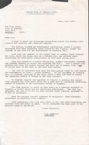
Document - VICTORIA HILL - LETTER TO THE TOWN CLERK FROM C. D. SHEUMACK
Typed letter from C . D. Sheumack, President of the Rotary Club of Bendigo South to The Town Clerk, City of Bendigo. Dated 14th July 1971. He is seeking approval and financial support to develop the vacant land opposite the Gold Mines Hotel for a park area. The Club desires to to erect a toilet block and Gas Barbeque provisions.document, memo, victoria hill, victoria hill, letter to the town clerk from c d sheumack, the bendigo tourist and development association, rotary club of bendigo south, gold mines hotel, c d sheumack -
 Bendigo Historical Society Inc.
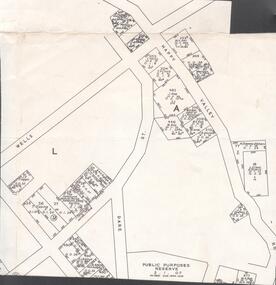
Map - VICTORIA HILL - MAP - HAPPY VALLEY RD - DARE ST
Small map showing some blocks of land in the Happy Valley Road, Dare Street and Wells Streets area. Three of the blocks are in the name of Rae. Notes by Albert Richardson.map, bendigo, victoria hill, victoria hill, victoria hill - map - happy valley road - dare street, w rae, j rae -
 Bendigo Historical Society Inc.
Document - VICTORIA HILL - NOTES ON VICTORIA HILL
Handwritten notes and typed copy, on Victoria Hill. Notes mention the completion of the Bendigo and District Tourist Association's Mining project, what can be seen in the area, the views of Bendigo from the top of the 68 feet high poppet legs, geological features and rock colourings in the open cuts, its direct link to Fortuna mansion and the one-time deepest mine workings in the world. On the back is a number of references and page numbers. Notes prepared by Albert Richardson.document, memo, victoria hill, victoria hill, notes on victoria hill, bendigo and district tourist association, new chum line, lansell's fortuna mansion, central nell gwynne -
 Bendigo Historical Society Inc.
Document - VICTORIA HILL - VICTORIA HILL PROJECT
Handwritten carbon copy of notes on the Victoria Hill Project. Notes contain recommendations and some history of the area. Notes prepared by Albert Richardson.document, gold, victoria hill, victoria hill, victoria hill project, mr eric wilkinson, wittscheibe's 'jewellers shop', the adventure, luffsman & sterry's, ballerstedt's open cut, j n macartney, bendigo goldfield registry for 1870, australian mining standard june 1st 1899 special edition, gold mine hotel, new chum hill (once known as the south victoria hill), central deborah, albert richardson