Showing 1059 items matching "boundaries"
-
 Ringwood and District Historical Society
Flyer, Land Sale Advertisement and auction notice - Range View Estate, Ringwood, Victoria - 1920
Advertisement for sale of 150 residential allotments with terms of sale, summary of local features and services, and map showing location and layout of subdivision within the boundary of Mitcham to the west of Ringwood, Victoria. Copy of newspaper advertisement (The Herald, Melbourne, Wednesday 3 March, 1920) refers to public auction date for Range View Estate Ringwood - Saturday, 27th March, 1920.Subdivision includes Deep Creek Road, Range View Grove, Warnes Road, Tarrangower Avenue, Prince Edward Avenue, James Avenue, and White Horse Road, Mitcham. Agents - Phillips & Nicholson, 281 Collins Street, Melbourne, Telephone Central 10907. -
 Bendigo Historical Society Inc.
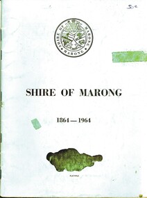
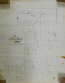
Book - SHIRE OF MARONG 1864 - 1964, 1964
Shire of Marong 1864 - 1964. A history of the shire. Contains Two (2) maps of the area on the inside back and front covers. Another illustration shows the division of the Electoral Boundaries and the types of Flora in each riding. At the back is an illustration indicating the break-up of the area with the names of The First Settlers (?) in these area. Blue cover. 36 pages. With index. B&W photos.book, bendigo, marong shire -
 Bendigo Historical Society Inc.
Document - MARKS COLLECTION: STRATHFIELDSAYE PLAN 1854
Plan drawn on light paper. Written on LH side of plan 'Plan of Part of the Parish of Strathfieldsaye 1854. Scale (shown) Lithographed at the Surveyor Generals Office, Melbourne July 10th. By I. Jones'. Plan shows Emu Creek and Village Reserve at top of plan, Shepherd's Creek on RH side, Parish Boundary Line on RH and bottom of plan.map, bendigo, shire of strathfieldsaye 1854 -
 City of Ballarat
Artwork, other - Public Artwork, Ratartat, Crossing Rubicon, 2008
“This public art project honours the people and suburb of Sebastopol, as well as providing a strong visual identity for Albert Street. It will make the street a lot more attractive and welcoming. The project is the outcome of extensive consultation with groups and individuals in the Sebastopol community, who have made suggestions both as to the nature of the project but also the aspects of life in their community they wanted to represent through the artwork.”Crossing Rubicon by Ratartat is located in Albert Street, Sebastopol, Ballarat. A row of 16 lampposts in Sebastopol’s main street are topped with large enamelled steel sculptures of trees, representing different aspects of Sebastopol’s community life and history. Ratartat is an artistic collaboration of Ballarat-based artists Geoff Bonney and Pete Widmer. The name, Crossing Rubicon, refers to Rubicon Street, the boundary between Redan and Sebastopol. The street was named after the Rubicon River, an ancient boundary between Italy and Gaul. Julius Caesar’s decision to cross the river, thereby rebelling against the Roman Senate, gave rise to the expression “crossing the Rubicon”, meaning going past the point of no return.Sixteen powder-coated steel sculptures mounted on light polesrubicon, sebastopol, ratartat -
 Ringwood and District Historical Society
Newspaper, Scrapbook Clipping, Library Collection, Ringwood, Victoria, `
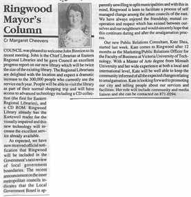
``Newspaper clipping from "The Post" 6-7-94 P9 Ringwood Mayor's Column. Cr Margaret Cheevers.Cr Cheevers welcomed John Binnion to the Ringwood library. He gave an excellent report on the progress of the new library.The Mayor also mentioned that Ringwood was in the government's next review of local government boundaries. A new Public Relations Consultant, Kate Shea, was welcomed to Ringwood Council` -
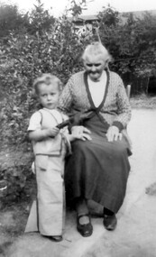 Surrey Hills Historical Society Collection
Photograph, Mary Selina Simpson, c1940
Mary Selina Inglefinger was born in 1856 in Kings Plain, NSW and was the eldest daughter of Joseph Inglefinger and his wife Maria Viktoria Bertel (Barthl), both of whom were born in Germany; they applied to come to Australia in 1854. They had 10 children, the first 8 born in Kings Plain. In 1879, Joseph Inglefinger bought James Staig's farm in Boundary (Warrigal) Road, near the corner of Bona Vista Avenue, Surrey Hills. The 1903 and 1905 electoral rolls list them in Boundary Road. In 1875 Mary married Charles Simpson, stepson of James Staig in Scots Church, Melbourne. They had 3 boys and 3 girls. This photograph was taken with her great-grandson in 1940.A black and white photograph of a lady sitting on a chair with a young toddler standing beside her.On back of photo: Mary Selina Simpson / (nee Inglefinger) / c.1940 / (born Mary Maghlina) / born c. 1857(miss) mary inglefinger, (mr) joseph inglefinger, (mr) james staig, warrigal road, surrey hills, bona vista avenue, (mrs) mary simpson, boundary road, (miss) mary maghlina inglefinger -
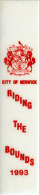 Narre Warren and District Family History Group
Textile, City of Berwick, Rosette/Ribbon Riding the Bounds City of Berwick 1993
The Riding of the Bounds was an annual event that took place in Berwick. It linked back to a centuries-old tradition in sister city Berwick upon Tweed, England. Riders followed a route through local streets and participate in ceremonies along the city's border. The Mayor would wave off riders from the local showgrounds with instructions to inspect the boundary with the neighbouring municipality. Once the ride was complete, the Marshall would report back to the Mayor that the boundaries were secure, and this would herald the commencement of the presentation ceremony. This re-enactment of the Berwick-Upon-Tweed Riding of the Bounds was filled with pomp and ceremony and many of the riders took the opportunity to dress in period costume in recognition of the history of this event. This information is from https://collection.casey.vic.gov.au/Ribbon for City of Berwick Riding the Bounds 1993. Printed on white material with red ink. Has the City of Berwick coat of arms at the top of the ribbon.city of berwick, riding the bounds, city of berwick coat of arms, horses, berwick boundaries -
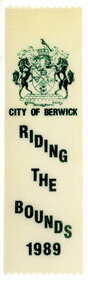 Narre Warren and District Family History Group
Textile, City of Berwick, Rosette/Ribbon Riding the Bounds City of Berwick 1989
The Riding of the Bounds was an annual event that took place in Berwick. It linked back to a centuries-old tradition in sister city Berwick upon Tweed, England. Riders followed a route through local streets and participate in ceremonies along the city's border. The Mayor would wave off riders from the local showgrounds with instructions to inspect the boundary with the neighbouring municipality. Once the ride was complete, the Marshall would report back to the Mayor that the boundaries were secure, and this would herald the commencement of the presentation ceremony. This re-enactment of the Berwick-Upon-Tweed Riding of the Bounds was filled with pomp and ceremony and many of the riders took the opportunity to dress in period costume in recognition of the history of this event. This information is from https://collection.casey.vic.gov.au/ Ribbon for City of Berwick Riding the Bounds 1989. Printed on white material with green ink. Has the City of Berwick coat of arms at the top of the ribbon. city of berwick, riding the bounds, city of berwick coat of arms, horses, berwick boundaries -
 Narre Warren and District Family History Group
Textile, City of Berwick, Rosette/Ribbon Riding the Bounds City of Berwick 1990
The Riding of the Bounds was an annual event that took place in Berwick. It linked back to a centuries-old tradition in sister city Berwick upon Tweed, England. Riders followed a route through local streets and participate in ceremonies along the city's border. The Mayor would wave off riders from the local showgrounds with instructions to inspect the boundary with the neighbouring municipality. Once the ride was complete, the Marshall would report back to the Mayor that the boundaries were secure, and this would herald the commencement of the presentation ceremony. This re-enactment of the Berwick-Upon-Tweed Riding of the Bounds was filled with pomp and ceremony and many of the riders took the opportunity to dress in period costume in recognition of the history of this event. This information is from https://collection.casey.vic.gov.au/Ribbon for City of Berwick Riding the Bounds 199. Printed on white material with red ink. Has the City of Berwick coat of arms at the top of the ribbon.city of berwick, riding the bounds, city of berwick coat of arms, horses, berwick boundaries -
 Narre Warren and District Family History Group
Textile, City of Berwick, Rosette/Ribbon Riding the Bounds City of Berwick 1991
The Riding of the Bounds was an annual event that took place in Berwick. It linked back to a centuries-old tradition in sister city Berwick upon Tweed, England. Riders followed a route through local streets and participate in ceremonies along the city's border. The Mayor would wave off riders from the local showgrounds with instructions to inspect the boundary with the neighbouring municipality. Once the ride was complete, the Marshall would report back to the Mayor that the boundaries were secure, and this would herald the commencement of the presentation ceremony. This re-enactment of the Berwick-Upon-Tweed Riding of the Bounds was filled with pomp and ceremony and many of the riders took the opportunity to dress in period costume in recognition of the history of this event. This information is from https://collection.casey.vic.gov.au/Ribbon for City of Berwick Riding the Bounds 19919. Printed on white material with blue ink. Has the City of Berwick coat of arms at the top of the ribbon.city of berwick, riding the bounds, city of berwick coat of arms, horses, berwick boundaries -
 Narre Warren and District Family History Group
Textile, City of Berwick, Rosette/Ribbon Riding the Bounds City of Berwick 1992
The Riding of the Bounds was an annual event that took place in Berwick. It linked back to a centuries-old tradition in sister city Berwick upon Tweed, England. Riders followed a route through local streets and participate in ceremonies along the city's border. The Mayor would wave off riders from the local showgrounds with instructions to inspect the boundary with the neighbouring municipality. Once the ride was complete, the Marshall would report back to the Mayor that the boundaries were secure, and this would herald the commencement of the presentation ceremony. This re-enactment of the Berwick-Upon-Tweed Riding of the Bounds was filled with pomp and ceremony and many of the riders took the opportunity to dress in period costume in recognition of the history of this event. This information is from https://collection.casey.vic.gov.au/Ribbon for City of Berwick Riding the Bounds 1992. Printed on white material with blue ink. Has the City of Berwick coat of arms at the top of the ribbon.city of berwick, riding the bounds, city of berwick coat of arms, horses, berwick boundaries -
 Eltham District Historical Society Inc
Photograph, Belle Vue, Livingstone Road, Eltham, c.1960, 1960c
Photo taken at time of ownership by Eric Staff. Originally purchased by pioneer Eltham farmer Henry Stooke, Belle Vue farm comprised about 56 ha (140 acres) extending northerly from the northern boundary of Holloway’s 1851 Little Eltham subdivision. On the present day map the southern boundary was just north of Elsa Court and Grove Street. The western boundary was the Diamond Creek and extended northerly to Main Road where it turns easterly towards Research. It was traversed by the main road to Kangaroo Ground and beyond and from 1912 by the railway to Hurstbridge. From 1895 the farm was owned by William Williams and his wife Mary Ann. In 1914-1915 they built a new house now known as “Belle Vue”. They sold the land in 1920 and residential subdivision began soon after that. “Belle Vue” remains today on a large residential lot in Livingstone Road. The house and many old trees on the site have been subject to a heritage overlay under the Nillumbik Planning Scheme. Despite that overlay, most of the heritage trees were removed during sub-division and development of the property.Digital file only from scan of copy on loan to EDHSbelle vue, eltham, eric staff, houses, livingstone road, staff family -
 Whitehorse Historical Society Inc.
Map - Parish Map, Parish of Nunawading, 1892
A map copied from 'Directory maps - parishes and counties' dated 26 Nov 1892. Compiled and lithographed by G.S. Bonney. The map includes roads, railway, stations, names of property owners. It has a scale [ca. 1:31,680] 40 chains to an 1 inch.A map copied from 'Directory maps - parishes and counties' dated 26 Nov 1892. Compiled and lithographed by G.S. Bonney. The map includes roads, railway, stations, names of property owners. It has a scale [ca. 1:31,680] 40 chains to an 1 inch.non-fictionA map copied from 'Directory maps - parishes and counties' dated 26 Nov 1892. Compiled and lithographed by G.S. Bonney. The map includes roads, railway, stations, names of property owners. It has a scale [ca. 1:31,680] 40 chains to an 1 inch.maps, parish of nunawading -
 Wycheproof & District Historical Society Inc.
Bunguluke Map, Bunguluke District In 1923, 27.2.1923
By 1881 Bunguluke was a small settlement as recorded, December 5, in the Charlton "Mercury". It reports that in that year Draper's Store, Hotel and Post Office and residence at Bunguluke North was totally destroyed by fire. For years now there has been little sign of community life with houses few and far between and acreages have gone into larger holdings. The map references land blocks and owners for that era.This important map shows the local land ownership and local features that existed in 1923. This is a photocopied black and white map of Bunguluke in the County of Kara Kara, Number L5149. Marked - Photo Lithographed by W.J. Butson 27.2.1923. The details include numbers of allotments, property owners, roads, rivers. The boundaries marked are the Parish of Jeruk, Parish of Wycheproof, Parish of Cooroopajerrup. Wycheproof township location is shown with the Scale of Chains. Bunguluke maps for other years are also in the collection.map, bunguluke, jeruk, wycheproof, cooroopajerrup -
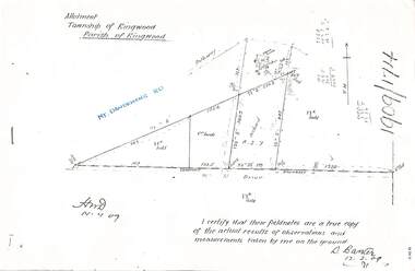 Ringwood and District Historical Society
Document - Copy of Lands Department Field Notes - Parish of Ringwood, Victoria, Field Notes 1909/174 - Part of O.P. R72D surveyed 12.3.1909
Foolscap size photocopy of survey map with handwritten notations. References include Mount Dandenong Road, pathway, 2 room house, scillion, shed, WC, 17C sold, Cr lands, orchard, 17E sold, Township boundary, I certify that these field notes are a true copy of the actual results of observations and measurements taken by me on the ground (signed) D. Barker 12.3.09. -
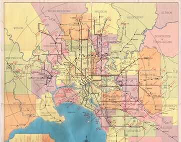 Ballarat Tramway Museum
Map, Compiled by MMTB, "Map and timetable of Melbourne Tram and Bus Services" - May 1956, May. 1956
Fold out map (10 sections), coloured of Melbourne's Tram and Bus routes, route numbers, rail lines, municipalities boundaries and location of major places of interest. At base of map - timetable of all night trams and bus services. On rear index to routes, 1st and last services, time of Sunday am services, Latrobe St. services and photo of Wattle Park.trams, tramways, melbourne, map, tram & bus services, all night services, mmtb -
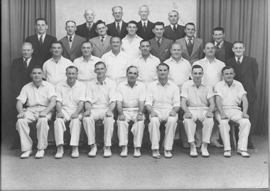 Port Melbourne Historical & Preservation Society
Photograph - Boundary Rovers (football) and Rising Sun Cricket Club, Premiers, Allan Studio, 1948
Large framed presentation of two photos of Rising Sun Hotel's Sunday League Premiership football and cricket teams ('Boundary Rovers' and 'Rising Sun Cricket Club' 1947-48, handlettered with details, including names of players. Brown frame (painted over beige-painted frame), beige surround, blue and black letterings. Ref item 1336 for matching program.Lettering blurred at toparchibald (arch) todd, sport - australian rules football, sport - cricket, societies clubs unions and other organisations, rising sun hotel, boundary rovers football club, rising sun cricket club, c mcauley, v butler, p darcy, w gibbons, r forrest, j thornhill, j williams, v coy, a pettiona, l boyce, c bulpitt, w payne, g pettiona, p johnson, tommy lahiff, j white, e byrce, t gibbs, william coy, a ferris, g sykes, jim coy, h florence, t duffy, w stuart, j millar, j pettiona, n gent, k marshall, a harrison, l dickson, s bulpitt, g sager, w pitts, g winchcombe, w ahale, w bowers, j collins, r murray, r trainer, j sawtell, s harrison, g beaton, j dobson, t brosnan, a martini, r harrison, m maher, a keeping, a 'nappy' ollington, business and traders - hotels -
 Bacchus Marsh & District Historical Society
Map, Coimadai Parish Map, County of Bourke. Circa 1890s-1900s
The cadastral Parish of Coimadai, a subdivision of the County of Bourke, lies directly north of the township of Bacchus Marsh. The date of this map is uncertain. T.F. McGauran the person who made a photo-lithographic copy of the map was in charge of photo-lithography at the Victorian Department of Lands and Survey in the late 19th century until about 1910.A single page paper map showing the map for the Parish of Coimadai in the County of Bourke. A cadastral map showing parish boundaries and land ownership. A rectangle shaped area is missing from the centre of the map due to a tear or deliberate excision. The map is pasted into a bound volume containing 76 maps or plans in total. High resolution digital image stored on BMDHS computer network. Photo-lithographed at the Department of Lands and Survey, Melbourne by T.F. McGauran 26.8.[??] NOTE. Photo litho from L.P showing temporary surveys and occupation of land prepared for departmental use onlybacchus marsh region parish plans, coimadai parish maps, coimadai parish plan -
 Ringwood and District Historical Society
Piece of Rock, Collected by J. Lundy-Clarke, Lump of Black Rock - Sample of Metamorphic Rock from Hubbard Park, Ringwood 1979, Found 1979
Sample of metamorphic rock encountered by M.M.B.W. gang of tunnellers boring for a sewer drain through a geological fault-dyke along the southern boundary of Hubbard Park. The hole for 900 feet of 12.5 inch pipe took 6 months to bore from Oct-1979 to May-1980.Lump of black rock. +Additional Keywords: Lundy-Clarke, J. -
Tatura Irrigation & Wartime Camps Museum
Print - Heaphy's Whim - Inn Framed Print, Heaphy's Whim Inn
The inn was located on the SW corner of the intersection now known as Dhurringile Rd and Hogan St. There is now no trace of the pictured building. This was the northern boundary of the James Winter estate and was called " Nelson Gate ". The town "whim " ( water pump ) was near the Brown St / Albert St round-a -boutBlack and white print in a black plastic frame with white card surround. Inn with horses and carts, people in the carts, people standing under verandah and off to the side. Wide section of road in front and trees behind -
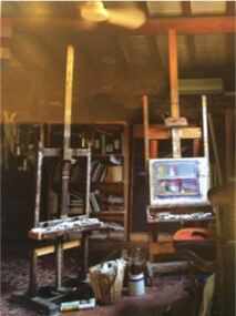 Federation University Art Collection
Artwork, other, Sonia Payes, Jeffrey Smart’s Studio' by Sonia Payes', 2007
Sonia PAYES (1956- ) Born Melbourne, Victoria Sonia Page is a conceptually-based artist Australian artist working with photography, multi-media, animation and sculpture. She continually pushes the boundaries between photography, sculptural work and new media, with a strong environmental narrative permeating her work. A large photographic tryptich depicting the studio of prominent Australian artist Jeffrey Smart. Sonia Payes art practice is grounded in her training as a photographer. In 2005 Sonia Payes started a large project involving photographing artist's portraits, art works and surrounds. Depicting the idiosyncratic, and often private, lives of artists the project resulted in a visual book titled ‘Untitled. Portraits of Australian Artists', published by McMillan Art Publishing in 2007. studio, eisel, geoffrey smart, sonia page -
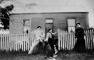 City of Kingston
Photograph - Black and white, c. 1910
The cottage was located on East Boundary Road, near Caleb Street in East Bentleigh. It was owned by Caleb Porter and occupied by Laura Johnson (centre). Also in the photograph are her sister Boletta Hansen Wold (left) and daughter Anna Marie Johnson (right). The dog's name has not been recordedPart of East Bentleigh was inside the original grant of land bought by English farmer and brewer, Henry Dendy, in 1841. He bought 5,120 acres (20.7 km2) which was bounded on the west by Port Phillip Bay, then North Road, East Boundary Road and South Road.Black and white image of three women and a dog standing outside a small weatherboard cottage with a picket fence. Round white sticker with black printed text: 140 Handwritten in red ink: 55%east bentleigh, caleb porter, laura johnson, boletta hansen wold, anna marie johnson -
 Ringwood and District Historical Society
Document - Department of Lands and Survey, Wire Netting Branch, Melbourne, Victoria, Application for Vermin-Proof Fence Certificate - L.J. Mills vs John Collins, Grandview Grove, Ringwood, Victoria - 1939
Photocopied file of corresponence and documentation relating to a claim by L.J. Mills, Nurseryman, that adjoining property owner, J. Collins, Farmer, assists with replacement of a vermin proof wire netting dividing fence destroyed by 1939 bushfire. File includes 1939 and 1940 detailed property inspection reports by Vermin and Noxious Weeds Branch, Lands Department, Lilydale, describing land use in the area and signs of vermin activity. Application approved 18th April, 1940. Appeal lodged by Mr Collins disallowed in May, 1940. File closed June, 1940 with Departmental suggesion that Mr Mills consider further legal action through a Solicitor as fence had still not been wire-netted. TRANSCRIPTS: Vermin & Noxious Weeds Inspection Reports "19/9/1939 (To) Superintendent (Department of Lands and Survey, Melbourne) Re L.J. Mills application for Vermin Proof Fence. I called on Mr Mills yesterday 18th instant in connection with this matter. Mr Mills has a flower farm and claims that rabbits and hares are damaging his flowers. He showed me a bed of carnations which he stated were being damaged by rabbits. There was evidence of some leaves being nipped off, but I am unable to say whether this is due to rabbits or grubs. Very little if any real damage is being done. The property is netted on the east and south boundary and on half the north and west boundary. The surrounding country is undlating and fairly steep in places. The land to the east across Grandview Avenue (sic) is all planted out in old established orchards and well cultivated. Cleared grass land adjoins the south boundary and bush land adjoins the north and west boundaries. I walked over a large area surrounding Mr Mills land and never saw any rabbits or hares or any indications of rabbits. This locality is not rabbit infested and very little wire netting is being used. I do not consider that a vermin proof fence is necessary between these allotments. - Jas H Allison (Inspector, Vermin and Noxious Weeds Branch, Lands Department, Lilydale)." Follow up report following renewal of application for Certificate by Mr Mills, citing rabbits causing considerable damage to his flowers. He laid poison and obtained 9 carcases and stated that there is evidence of rabbit infestation from the adjoing land. "19/3/1940 (To) Mr Hannah (Superintendant, Department of Lands and Survey, Melbourne) Re L.J. Mills, Grandview Grove Ringwood, Lot 4 Grandview Estate Pt CG20 Ph of Warrandyte. I interviewed Mr Mills at his home on 15th inst. He showed me carcases of rabbits which he stated had been poisoned on his land. In places young plants had been nipped off apparently by rabbits. I made an inspection of adjoining properties and found one live burrow close to Mr Mills northern boundary. There were scratches and other evidence of rabbits on land north and west of Mr Mills property. In view of the present evidence of rabbits I consider that a vermin proof fence is now necessary to protect the flowers grown by Mr Mills. His land is netted on whole of east and south boundary and half way on west and north boundary. The adjoining land on west and north boundaries is owned by Mrs Linda Collins and John Collins resp of Brysons Road East Ringwood. - Jas H Allison (Inspector, Vermin and Noxious Weeds Branch, Lands Department, Lilydale)." -
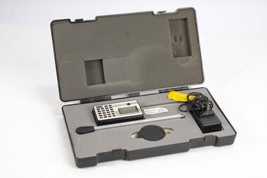 Department of Energy, Environment and Climate Action
Planimeter (Digital)
The heavy weight is pinned onto the map and the tracing arm is used to follow the boundary to be measured. Reading from the digital scale the area in square centimetres could be measured. Knowing the scale of the mapsheet the figure was converted to areas or hectares Generally at least three measurements were taken to ensure accuracy and precisionPlanimeter used to measure areas from scale maps. Kent Planitron UP103forests commission victoria (fcv), forest measurement, surveying -
 Eltham District Historical Society Inc
Colour Print, David Taylor, Western boundary, Eltham High School, c.1976
View looking north towards intersection of Susan Street and present-day Withers Way, behind the school near the western boundary. To the left of the photo is the housing development of Cronus Court. Aerial photos for 1976 reflect the undeveloped landscape as viewed. By 1981 the estate was well established with all houses built.david taylor collection, eltham, eltham high school, cronus court, susan street, withers way -
Bendigo Historical Society Inc.
Map - MAP WHITE HILL TO HUNTLY
Map of Bendigo creek and adjacent leads - White Hills to Huntly replotted from old 4 chain to 1 inch survey of 1860 by G. W. Hart - Surveyor. Base of roads and streets taken from D.L.S. 1 . 10000 base maps. Legend: battery site, puddling mill site, dam bank site, cutting altering course of creek, lead boundaries.bendigo, mining -
 Bayside Gallery - Bayside City Council Art & Heritage Collection
Map, Department of Lands and Survey, Land under the control of the City of Sandringham, 1962
The cadastral map showing land under the control of the City of Brighton in 1962.map, plan, foreshores, sndringham, hampton, beaumaris, cheltenham, department of lands and survey, cartographic material, moorabbin, black rock, street map, city of sandringham, board of lands and works -
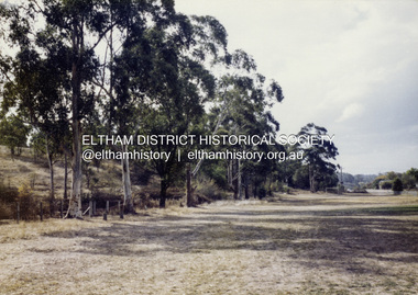
 Eltham District Historical Society Inc
Photograph, Looking north along Ryans Road at intersection with Kerrie Crescent, Eltham, c.October 1989, 1989
Ryans Road was reconstructed and sealed to the north of Kerrie Crescent in 1983. Roundabout and southern reconstruction added later. This photo is probably shortly after construction of roundabout (before 1991 when Doug Orford photographed all the Shire boundaries as roundabout was well planted at that stage) Cross Ref: 04070 and 01878-25Roll of 35mm colour negative film, 1 stripsFuji 100eltham north, kerrie crescent, round about, ryans road, streets -
 Greensborough Historical Society
Photograph - Digital image, Jasmin Burge, Grimshaw Street trees 2012, 19/06/2012
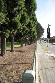
Trees along the Grimshaw Street boundary of Loyola College. Part of a collection of photographs of Loyola College, Grimshaw Street Watsonia, established 1980 on the site of the Loyola Seminary. The College purchased the original building in 2002. These photographs of the original building and grounds were taken by GHS member Jazz Burge in June 2012.Digital copy of 2 colour photographs.loyola college, grimshaw street -
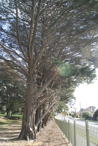 Greensborough Historical Society
Photograph - Digital image, Jasmin Burge, Trees, Loyola 2012, 19/06/2012
Trees along boundary fence, Loyola College 2012. Part of a collection of photographs of Loyola College, Grimshaw Street Watsonia, established 1980 on the site of the Loyola Seminary. The College purchased the original building in 2002. These photographs of the original building and grounds were taken by GHS member Jazz Burge in June 2012.Digital copy of colour photograph.loyola college