Showing 505 items
matching constructional engineers
-
 Kew Historical Society Inc
Plan, Melbourne & Metropolitan Board of Works : Borough of Kew : Detail Plan No.1569, 1905
The Melbourne and Metropolitan Board of Works (MMBW) plans were produced from the 1890s to the 1950s. They were crucial to the design and development of Melbourne's sewerage and drainage system. The plans, at a scale of 40 feet to 1 inch (1:480), provide a detailed historical record of Melbourne streetscapes and environmental features. Each plan covers one or two street blocks (roughly six streets), showing details of buildings, including garden layouts and ownership boundaries, and features such as laneways, drains, bridges, parks, municipal boundaries and other prominent landmarks as they existed at the time each plan was produced. (Source: State Library of Victoria)This plan forms part of a large group of MMBW plans and maps that was donated to the Society by the Mr Poulter, City Engineer of the City of Kew in 1989. Within this collection, thirty-five hand-coloured plans, backed with linen, are of statewide significance as they include annotations that provide details of construction materials used in buildings in the first decade of the 20th century as well as additional information about land ownership and usage. The copies in the Public Record Office Victoria and the State Library of Victoria are monochrome versions which do not denote building materials so that the maps in this collection are invaluable and unique tools for researchers and heritage consultants. A number of the plans are not held in the collection of the State Library of Victoria so they have the additional attribute of rarity.Original survey plan, issued by the MMBW to a contractor with responsibility for constructing sewers in the area identified on the plan within the Borough of Kew. The plan was at some stage hand-coloured, possibly by the contractor, but more likely by officers working in the Engineering Department of the Borough and later Town, then City of Kew. The hand-coloured sections of buildings on the plan were used to denote masonry or brick constructions (pink), weatherboard constructions (yellow), and public buildings (grey). This plan covers parts of Sackville Street, John Street, Thomas Street and Cotham Road, and includes several very large houses in Sackville Street. Job Smith built ‘Berrington’ in about 1888-90 for himself, and ‘Pomeroy’ (now ‘Merridale’) in 1885 for James Mickleburgh. ‘Heathfield’ was built in 1888 for Henry Eeles, and was one of many fine homes in Kew, Hawthorn and surrounding suburbs designed by prolific architect John Beswicke; it later became “La Verna” and was a Franciscan monastery. Similarly, in Cotham Road, we can see ‘Bella Vista’ (now demolished), and ‘Charleville’, with its double-storeyed arcade frontage, built in 1889 for Charles Donaldson whose family occupied it until 1939. This was renamed ‘Ross House’ by the second owner, Dr. Thomas King, and then substantially restored in the 1960s by the Stillwell family, well known as car drivers and dealers. Bella Vista (later ‘Malinda’) was originally designed by the architect Robert Haddon and built for Abel Hoadley, inventor of the Violet Crumble Bar and many other delicious delicacies. He began by manufacturing jams and pickles in South Melbourne using fruit from his own orchard in East Burwood.melbourne and metropolitan board of works, detail plans, mmbw 1569, cartography -
 Kew Historical Society Inc
Plan, Melbourne & Metropolitan Board of Works : Borough of Kew : Detail Plan No.1570, 1905
The Melbourne and Metropolitan Board of Works (MMBW) plans were produced from the 1890s to the 1950s. They were crucial to the design and development of Melbourne's sewerage and drainage system. The plans, at a scale of 40 feet to 1 inch (1:480), provide a detailed historical record of Melbourne streetscapes and environmental features. Each plan covers one or two street blocks (roughly six streets), showing details of buildings, including garden layouts and ownership boundaries, and features such as laneways, drains, bridges, parks, municipal boundaries and other prominent landmarks as they existed at the time each plan was produced. (Source: State Library of Victoria)This plan forms part of a large group of MMBW plans and maps that was donated to the Society by the Mr Poulter, City Engineer of the City of Kew in 1989. Within this collection, thirty-five hand-coloured plans, backed with linen, are of statewide significance as they include annotations that provide details of construction materials used in buildings in the first decade of the 20th century as well as additional information about land ownership and usage. The copies in the Public Record Office Victoria and the State Library of Victoria are monochrome versions which do not denote building materials so that the maps in this collection are invaluable and unique tools for researchers and heritage consultants. A number of the plans are not held in the collection of the State Library of Victoria so they have the additional attribute of rarity.Original survey plan, issued by the MMBW to a contractor with responsibility for constructing sewers in the area identified on the plan within the Borough of Kew. The plan was at some stage hand-coloured, possibly by the contractor, but more likely by officers working in the Engineering Department of the Borough and later Town, then City of Kew. The hand-coloured sections of buildings on the plan were used to denote masonry or brick constructions (pink), weatherboard constructions (yellow), and public buildings (grey). Plan No.1570 shows the layout of gardens and houses in Sackville Street, Davis Street, Wrixon Street, and Fitzwilliam Street in 1904. While Thomas Street is included on the map, at this stage no houses had been built. The plan identifies two named houses: ‘Fairview’ and ‘Kylemore’. Fairview is more fully delineated in Plan No.1563. Kylemore is one of the few houses in Kew designed by John Beswicke. The most notable owner of Kylemore was William Whitehead, who owned the house between 1895 and 1900. In 1894, Australian newspapers reported the marriage of Whitehead’s daughter to Dr. Gerald Eugene Cussen, the brother of Sir Leo Cussen, the Supreme Court Judge. The married couple was to live at ‘Wilton’ (now the Kew RSL) from 1911-15.melbourne and metropolitan board of works, detail plans, mmbw 1570, cartography -
 Kew Historical Society Inc
Plan, Melbourne & Metropolitan Board of Works : Borough of Kew : Detail Plan No.1571, 1904
The Melbourne and Metropolitan Board of Works (MMBW) plans were produced from the 1890s to the 1950s. They were crucial to the design and development of Melbourne's sewerage and drainage system. The plans, at a scale of 40 feet to 1 inch (1:480), provide a detailed historical record of Melbourne streetscapes and environmental features. Each plan covers one or two street blocks (roughly six streets), showing details of buildings, including garden layouts and ownership boundaries, and features such as laneways, drains, bridges, parks, municipal boundaries and other prominent landmarks as they existed at the time each plan was produced. (Source: State Library of Victoria)This plan forms part of a large group of MMBW plans and maps that was donated to the Society by the Mr Poulter, City Engineer of the City of Kew in 1989. Within this collection, thirty-five hand-coloured plans, backed with linen, are of statewide significance as they include annotations that provide details of construction materials used in buildings in the first decade of the 20th century as well as additional information about land ownership and usage. The copies in the Public Record Office Victoria and the State Library of Victoria are monochrome versions which do not denote building materials so that the maps in this collection are invaluable and unique tools for researchers and heritage consultants. A number of the plans are not held in the collection of the State Library of Victoria so they have the additional attribute of rarity.Digital copy of the original survey plan, issued by the MMBW to a contractor with responsibility for constructing sewers in the area identified on the plan within the Borough of Kew. The plan was at some stage hand-coloured, possibly by the contractor, but more likely by officers working in the Engineering Department of the Borough and later Town, then City of Kew. The hand-coloured sections of buildings on the plan were used to denote masonry or brick constructions (pink), weatherboard constructions (yellow), and public buildings (grey). This plan is part of a large and historically significant group of MMBW plans and maps that was donated to the Society by the Mr Poulter, City Engineer of the City of Kew in 1989. When the contracts were let for surveyors to identify and record the extant houses and landscapes within an area for the Board of Works, the contracts were let at separate times, hence the anomaly where two copies of Plan No.1571 exist in our collection. The first of these plans identifies the building materials used in houses bordering Fitzwilliam Street, Edgevale Road, May Street, Malin Street, Davis Street and Wellington Street. The cut off point for the survey was the south side of Wellington Street. By 1903 when the survey was undertaken many of the sites were already built on, particularly those facing Edgevale Road. The plan identifies the preponderance of weatherboard houses in the area. The other version of the plan identifies the buildings between Wellington Street and Cotham Road.melbourne and metropolitan board of works, detail plans, mmbw 1571, cartography -
 Kew Historical Society Inc
Plan, Melbourne & Metropolitan Board of Works : Borough of Kew : Detail Plan No.1571, 1904
The Melbourne and Metropolitan Board of Works (MMBW) plans were produced from the 1890s to the 1950s. They were crucial to the design and development of Melbourne's sewerage and drainage system. The plans, at a scale of 40 feet to 1 inch (1:480), provide a detailed historical record of Melbourne streetscapes and environmental features. Each plan covers one or two street blocks (roughly six streets), showing details of buildings, including garden layouts and ownership boundaries, and features such as laneways, drains, bridges, parks, municipal boundaries and other prominent landmarks as they existed at the time each plan was produced. (Source: State Library of Victoria)This plan forms part of a large group of MMBW plans and maps that was donated to the Society by the Mr Poulter, City Engineer of the City of Kew in 1989. Within this collection, thirty-five hand-coloured plans, backed with linen, are of statewide significance as they include annotations that provide details of construction materials used in buildings in the first decade of the 20th century as well as additional information about land ownership and usage. The copies in the Public Record Office Victoria and the State Library of Victoria are monochrome versions which do not denote building materials so that the maps in this collection are invaluable and unique tools for researchers and heritage consultants. A number of the plans are not held in the collection of the State Library of Victoria so they have the additional attribute of rarity.Original survey plan, issued by the MMBW to a contractor with responsibility for constructing sewers in the area identified on the plan within the Borough of Kew. The plan was at some stage hand-coloured, possibly by the contractor, but more likely by officers working in the Engineering Department of the Borough and later Town, then City of Kew. The hand-coloured sections of buildings on the plan were used to denote masonry or brick constructions (pink), weatherboard constructions (yellow), and public buildings (grey). This plan is the other half of Plan No.1571 representing the constructions to the west of Wellington Street before and in 1903/4. This plan represents the built environment in Edgevale Road, Wellington Street, Atkins Street, Annadale Street, Mortimer Street, and Cotham Road. Whereas there are smaller allotments and more modest housing stock facing Edgevale Road, larger blocks and more substantial houses are represented facing Cotham Road.melbourne and metropolitan board of works, detail plans, mmbw 1571, cartography -
 Kew Historical Society Inc
Plan, Melbourne & Metropolitan Board of Works : Borough of Kew : Detail Plan No.1572, 1905
The Melbourne and Metropolitan Board of Works (MMBW) plans were produced from the 1890s to the 1950s. They were crucial to the design and development of Melbourne's sewerage and drainage system. The plans, at a scale of 40 feet to 1 inch (1:480), provide a detailed historical record of Melbourne streetscapes and environmental features. Each plan covers one or two street blocks (roughly six streets), showing details of buildings, including garden layouts and ownership boundaries, and features such as laneways, drains, bridges, parks, municipal boundaries and other prominent landmarks as they existed at the time each plan was produced. (Source: State Library of Victoria)This plan forms part of a large group of MMBW plans and maps that was donated to the Society by the Mr Poulter, City Engineer of the City of Kew in 1989. Within this collection, thirty-five hand-coloured plans, backed with linen, are of statewide significance as they include annotations that provide details of construction materials used in buildings in the first decade of the 20th century as well as additional information about land ownership and usage. The copies in the Public Record Office Victoria and the State Library of Victoria are monochrome versions which do not denote building materials so that the maps in this collection are invaluable and unique tools for researchers and heritage consultants. A number of the plans are not held in the collection of the State Library of Victoria so they have the additional attribute of rarity.Original survey plan, issued by the MMBW to a contractor with responsibility for constructing sewers in the area identified on the plan within the Borough of Kew. The plan was at some stage hand-coloured, possibly by the contractor, but more likely by officers working in the Engineering Department of the Borough and later Town, then City of Kew. The hand-coloured sections of buildings on the plan were used to denote masonry or brick constructions (pink), weatherboard constructions (yellow), and public buildings (grey). Plan No. 1572 represents the built environment bordered by Barkers Road, Wrixon Street, Edgevale Road and Fitzwilliam Street. Other streets identified on the plan include Stansell Street. Plan 1572 shows that by 1903-05, there was only patchy development in this area of Kew, mainly on Edgevale Road and Fitzwilliam Street. Only two named houses are identified: the quaintly named ‘Tweed Cottage’, and ‘Mendip’. The earliest reference to Treed Cottage in Australian newspapers is to the death of Walter Thompson, aged 74 who was a resident there in 1885. His youngest daughter was to die there in 1908. Mendip to the north of Tweed Cottage was owned by Henry Thompson; he was to die in 1901; his wife in 1932. At this period of time, Malin Street and Clivedon Court did not extend to Barkers Road.melbourne and metropolitan board of works, detail plans, mmbw 1572, cartography -
 Kew Historical Society Inc
Plan, Melbourne & Metropolitan Board of Works : Borough of Kew : Detail Plan No.1573, 1905
The Melbourne and Metropolitan Board of Works (MMBW) plans were produced from the 1890s to the 1950s. They were crucial to the design and development of Melbourne's sewerage and drainage system. The plans, at a scale of 40 feet to 1 inch (1:480), provide a detailed historical record of Melbourne streetscapes and environmental features. Each plan covers one or two street blocks (roughly six streets), showing details of buildings, including garden layouts and ownership boundaries, and features such as laneways, drains, bridges, parks, municipal boundaries and other prominent landmarks as they existed at the time each plan was produced. (Source: State Library of Victoria)This plan forms part of a large group of MMBW plans and maps that was donated to the Society by the Mr Poulter, City Engineer of the City of Kew in 1989. Within this collection, thirty-five hand-coloured plans, backed with linen, are of statewide significance as they include annotations that provide details of construction materials used in buildings in the first decade of the 20th century as well as additional information about land ownership and usage. The copies in the Public Record Office Victoria and the State Library of Victoria are monochrome versions which do not denote building materials so that the maps in this collection are invaluable and unique tools for researchers and heritage consultants. A number of the plans are not held in the collection of the State Library of Victoria so they have the additional attribute of rarity.Original survey plan, issued by the MMBW to a contractor with responsibility for constructing sewers in the area identified on the plan within the Borough of Kew. The plan was at some stage hand-coloured, possibly by the contractor, but more likely by officers working in the Engineering Department of the Borough and later Town, then City of Kew. The hand-coloured sections of buildings on the plan were used to denote masonry or brick constructions (pink), weatherboard constructions (yellow), and public buildings (grey). This plan has detailed annotations written in red or blue ink, showing prices, which may be the annual valuations of the properties, and some owners’ names, a most unusual feature on contractor's maps. Some areas, such as the buildings of Methodist Ladies’ College (MLC), include the school’s tennis court and swimming pool, but are not coloured to show building materials – did the draftsman just run out of time, or ink, or enthusiasm, before his plan had to be submitted? MLC had been founded in 1882 as a ‘modern school of the first order’ with buildings that formed ‘a collegiate institution for girls unsurpassed in the colonies’. The goal of its founders was to provide a high-class Christian education for girls, comparable with that provided elsewhere for boys. Some shops are shown along Edgevale Road, though they are not designated as commercial premises. Larger houses are depicted, including ‘Fairlawn’ in Barkers Road, and ‘Clevedon’ and ‘Rosehill’ (now demolished) in Fitzwilliam Street.melbourne and metropolitan board of works, detail plans, mmbw 1573, maps - borough of kew, cartography -
 Kew Historical Society Inc
Plan, Melbourne & Metropolitan Board of Works : Borough of Kew : Detail Plan No.1574, 1905
The Melbourne and Metropolitan Board of Works (MMBW) plans were produced from the 1890s to the 1950s. They were crucial to the design and development of Melbourne's sewerage and drainage system. The plans, at a scale of 40 feet to 1 inch (1:480), provide a detailed historical record of Melbourne streetscapes and environmental features. Each plan covers one or two street blocks (roughly six streets), showing details of buildings, including garden layouts and ownership boundaries, and features such as laneways, drains, bridges, parks, municipal boundaries and other prominent landmarks as they existed at the time each plan was produced. (Source: State Library of Victoria)This plan forms part of a large group of MMBW plans and maps that was donated to the Society by the Mr Poulter, City Engineer of the City of Kew in 1989. Within this collection, thirty-five hand-coloured plans, backed with linen, are of statewide significance as they include annotations that provide details of construction materials used in buildings in the first decade of the 20th century as well as additional information about land ownership and usage. The copies in the Public Record Office Victoria and the State Library of Victoria are monochrome versions which do not denote building materials so that the maps in this collection are invaluable and unique tools for researchers and heritage consultants. A number of the plans are not held in the collection of the State Library of Victoria so they have the additional attribute of rarity.Original survey plan, issued by the MMBW to a contractor with responsibility for constructing sewers in the area identified on the plan within the Borough of Kew. The plan was at some stage hand-coloured, possibly by the contractor, but more likely by officers working in the Engineering Department of the Borough and later Town, then City of Kew. The hand-coloured sections of buildings on the plan were used to denote masonry or brick constructions (pink), weatherboard constructions (yellow), and public buildings (grey). This plan shows several very large houses, particularly along Glenferrie Road, and the area now occupied by Ruyton Girls’ School. ‘Tarring’ (incorrectly spelled here as ‘Karring’) was built for Henry Henty in 1872, on part of his original allotment of 20 acres, and ‘Mount View’, which retains its original building and the fountain in the front garden, is part of Ruyton’s Junior School. The most significant change to Tarring and its grounds since 1903, involve the removal of a number of the outbuildings, including a Burmese temple, bought by Henty from the Burmese Exhibit at the Great Exhibition of 1880. It is shown on the plan as a summerhouse. The two-storey mansion, on the corner of Glenferrie Road and Wellington Street, was built in 1891 by leading architect Alfred White as his own home. Having an initial N.A.V. of £160, the house was purchased by a warehouseman Henry Lister, by 1900, when the N.A.V. was recorded at £111. By the turn of the century the house was known as ‘Comaques’. By contrast, much smaller houses are shown in Scott and Byron Streets, including a tiny Mission Hall in Byron Street, which belonged to the Anglican Church from at least 1903 to 1917.melbourne and metropolitan board of works, detail plans, maps - borough of kew, mmbw 1574, cartography -
 Kew Historical Society Inc
Plan, Melbourne & Metropolitan Board of Works : Borough of Kew : Detail Plan No.1575, 1905
The Melbourne and Metropolitan Board of Works (MMBW) plans were produced from the 1890s to the 1950s. They were crucial to the design and development of Melbourne's sewerage and drainage system. The plans, at a scale of 40 feet to 1 inch (1:480), provide a detailed historical record of Melbourne streetscapes and environmental features. Each plan covers one or two street blocks (roughly six streets), showing details of buildings, including garden layouts and ownership boundaries, and features such as laneways, drains, bridges, parks, municipal boundaries and other prominent landmarks as they existed at the time each plan was produced. (Source: State Library of Victoria)This plan forms part of a large group of MMBW plans and maps that was donated to the Society by the Mr Poulter, City Engineer of the City of Kew in 1989. Within this collection, thirty-five hand-coloured plans, backed with linen, are of statewide significance as they include annotations that provide details of construction materials used in buildings in the first decade of the 20th century as well as additional information about land ownership and usage. The copies in the Public Record Office Victoria and the State Library of Victoria are monochrome versions which do not denote building materials so that the maps in this collection are invaluable and unique tools for researchers and heritage consultants. A number of the plans are not held in the collection of the State Library of Victoria so they have the additional attribute of rarity.Original survey plan, issued by the MMBW to a contractor with responsibility for constructing sewers in the area identified on the plan within the Borough of Kew. The plan was at some stage hand-coloured, possibly by the contractor, but more likely by officers working in the Engineering Department of the Borough and later Town, then City of Kew. The hand-coloured sections of buildings on the plan were used to denote masonry or brick constructions (pink), weatherboard constructions (yellow), and public buildings (grey). Plan No.1575 shows that in the area bounded by Wellington Street, Edgevale Road, Glenferrie Road, and Cotham Road, there had already been significant subdivision of land and houses constructed. As one of the highest points in Kew, as expected, there were already some significant mansions built on large allotments of land. Many of these mansions are identified by name on the plan such as ‘Kelso’, ‘Abbotsford’, ‘Clarendon’ and ‘Ashlyn’ in Cotham Road. Other houses of equal size are unnamed on the plan.melbourne and metropolitan board of works, detail plans, maps - borough of kew, mmbw 1575, cartography -
 RMIT GSBL Justice Smith Collection
Book series, Duncan Wallace, I.N, Hudson's building and engineering contracts including the duties and liabilities of architects, engineers and surveyors, 1970
Previous owner: T. H. SmithTenth edition No. of volumes: 1 Volume range: 1-2 Missing volumes: 2ISBN: 0421132108engineering contracts, construction contracts -
 Kew Historical Society Inc
Photograph - Construction of the Kew Civic Centre, 1972
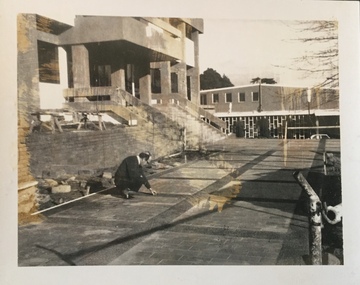
The Kew Civic Centre, as opposed to the adjacent Kew Civic Hall (see also Kew City Hall), was built to house a new Council Chamber and Council Offices in 1972. The Kew Library was to be located on the ground floor and accessed from the current carpark. This building replaced the former Town Hall in Walpole Street, Kew which had served as a town hall from 1865-1972. After the sale of the old Town Hall, the new Civic Centre was built to a design of the architects A K Lines, MacFarlane & Marshall. A fit-out of the building was still occurring when councillors and council officers moved into the building. In 1987, the Kew Library (and the Kew Historical Society) moved across the road to the reconfigured Civic Hall. The Civic Centre, pictured here, was ultimately sold to Trinity Grammar School following the amalgamation of Kew into the City of Boroondara.These four black and white photographs were taken by a photographer in the City Engineer's Department during the final construction phase. Each is dated and inscribed with a description.Laying of concrete tiles in the forecourt of the new Kew Civic Centre in 1972. The Civic Hall (now the Kew Library) is in the background. Annotated verso: "Civic Centre - Forecourt / 17.7.72"kew civic centre, kew civic offices, city of kew -- council chamber -
 Kew Historical Society Inc
Photograph - Construction of the Kew Civic Centre, 1972
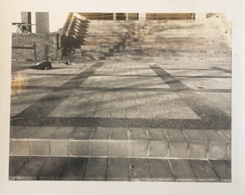
The Kew Civic Centre, as opposed to the adjacent Kew Civic Hall (see also Kew City Hall), was built to house a new Council Chamber and Council Offices in 1972. The Kew Library was to be located on the ground floor and accessed from the current carpark. This building replaced the former Town Hall in Walpole Street, Kew which had served as a town hall from 1865-1972. After the sale of the old Town Hall, the new Civic Centre was built to a design of the architects A K Lines, MacFarlane & Marshall. A fit-out of the building was still occurring when councillors and council officers moved into the building. In 1987, the Kew Library (and the Kew Historical Society) moved across the road to the reconfigured Civic Hall. The Civic Centre, pictured here, was ultimately sold to Trinity Grammar School following the amalgamation of Kew into the City of Boroondara.These four black and white photographs were taken by a photographer in the City Engineer's Department during the final construction phase. Each is dated and inscribed with a description.Forecourt of the new Kew Civic Centre in 1972.Annotated verso: "Civic Centre - Forecourt / 16.7.72"kew civic centre, kew civic offices, city of kew -- council chamber -
 Kew Historical Society Inc
Photograph - Construction of the Kew Civic Centre, 1972
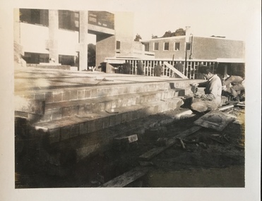
The Kew Civic Centre, as opposed to the adjacent Kew Civic Hall (see also Kew City Hall), was built to house a new Council Chamber and Council Offices in 1972. The Kew Library was to be located on the ground floor and accessed from the current carpark. This building replaced the former Town Hall in Walpole Street, Kew which had served as a town hall from 1865-1972. After the sale of the old Town Hall, the new Civic Centre was built to a design of the architects A K Lines, MacFarlane & Marshall. A fit-out of the building was still occurring when councillors and council officers moved into the building. In 1987, the Kew Library (and the Kew Historical Society) moved across the road to the reconfigured Civic Hall. The Civic Centre, pictured here, was ultimately sold to Trinity Grammar School following the amalgamation of Kew into the City of Boroondara.These four black and white photographs were taken by a photographer in the City Engineer's Department during the final construction phase. Each is dated and inscribed with a description.Tiling the steps leading from the forecourt to the new Kew Civic Centre in 1972.Annotated verso: "Civic Centre - Forecourt / 16.7.72"kew civic centre, kew civic offices, city of kew -- council chamber -
 Kew Historical Society Inc
Photograph - Construction of the Kew Civic Centre, 1972
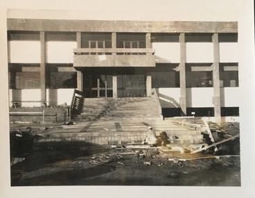
The Kew Civic Centre, as opposed to the adjacent Kew Civic Hall (see also Kew City Hall), was built to house a new Council Chamber and Council Offices in 1972. The Kew Library was to be located on the ground floor and accessed from the current carpark. This building replaced the former Town Hall in Walpole Street, Kew which had served as a town hall from 1865-1972. After the sale of the old Town Hall, the new Civic Centre was built to a design of the architects A K Lines, MacFarlane & Marshall. A fit-out of the building was still occurring when councillors and council officers moved into the building. In 1987, the Kew Library (and the Kew Historical Society) moved across the road to the reconfigured Civic Hall. The Civic Centre, pictured here, was ultimately sold to Trinity Grammar School following the amalgamation of Kew into the City of Boroondara.These four black and white photographs were taken by a photographer in the City Engineer's Department during the final construction phase. Each is dated and inscribed with a description.Creating the forecourt to the new Kew Civic Centre in 1972.Annotated verso: "Civic Centre - Forecourt / 16.7.72"kew civic centre, kew civic offices, city of kew -- council chamber -
 Kew Historical Society Inc
Photograph - Kew Main Drain, 1984
'Kew, Kew East, Balwyn & Balwyn North are located approximately 7km north east of Melbourne. Four main stormwater drains service the area flowing from south to north. Three of the drains: Deepdene Drain; Balwyn Drain & Glass Creek converge in Kew East just west of Burke Road at Kew High School before discharging into the Yarra River. The fourth drain, Kew Main Drain connects directly with the Yarra River to the West of Glass Creek.' The Kew Main Drain is a barrel drain that was created in the 1930s, and follows the route of the former Connor's Creek from the vicinity of Genazzano FCJ College to the Yarra River in East KewImportant and verifiable evidence of the construction methods used by the Melbourne & Metropolitan Board of Works in building the Kew Main Drain, before its reconstruction in c.1985.Original print colour positive photograph of the Kew Main Drain, provided on 14/12.84 to the Chief Engineer of the City of Kew, Ian Poulter, by the Supervising Engineer (Works), Southern and Eastern Drainage, Melbourne & Metropolitan Board of Works. The record includes an image of the reverse as well as the donation document from the MMBW."A84/1855-9 / 750mm council drain looking D/S [down stream] and across Parkhill Road. To be replaced with 1200 mm R.C.P. [reinforced concrete pipe] as part of MMBW Kew Main Drain reconstruction works"kew main drain, stormwater drains -- kew (vic.), connor's creek -- kew (vic.) -
 Kew Historical Society Inc
Photograph - Kew Main Drain, 1984
'Kew, Kew East, Balwyn & Balwyn North are located approximately 7km north east of Melbourne. Four main stormwater drains service the area flowing from south to north. Three of the drains: Deepdene Drain; Balwyn Drain & Glass Creek converge in Kew East just west of Burke Road at Kew High School before discharging into the Yarra River. The fourth drain, Kew Main Drain connects directly with the Yarra River to the West of Glass Creek.' The Kew Main Drain is a barrel drain that was created in the 1930s, and follows the route of the former Connor's Creek from the vicinity of Genazzano FCJ College to the Yarra River in East KewImportant and verifiable evidence of the construction methods used by the Melbourne & Metropolitan Board of Works in building the Kew Main Drain, before its reconstruction in c.1985.Original print colour positive photograph of the Kew Main Drain, provided on 14/12.84 to the Chief Engineer of the City of Kew, Ian Poulter, by the Supervising Engineer (Works), Southern and Eastern Drainage, Melbourne & Metropolitan Board of Works. The record includes an image of the reverse as well as the donation document from the MMBW."A84/1855-10 / 750mm council drain looking U/S [up stream] from Parkhill Road, Kew."kew main drain, stormwater drains -- kew (vic.), connor's creek -- kew (vic.) -
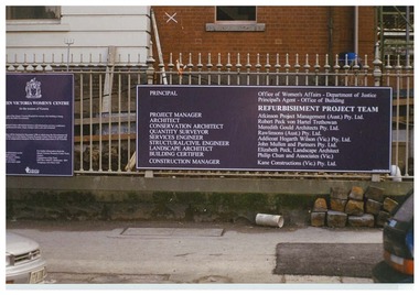 Queen Victoria Women's Centre
Photograph, c.1995/1996
Colour photograph. The board which was outside the QVWC building's gates on Lonsdale street. which details main groups involved in refurbishment of the building. "Principle: Office of Women's Affairs - Department of Justice. Principle Agent - Office of Building. Refurbishment Project Team. Project manager: Atkinson Project Management (Aust.) Pty. Ltd. Architects: Robert Peck won Hartel Trethowan. Conservation Architect: Meredith Gould Architects Pty. Ltd. Quantity Surveyor: Rawlinsons (Aust.) Pty. Ltd. Services Engineer: Addicoat Hogarth WIlson (Vic) Pty. Ltd. Structural/Civil Engineer: John Mulle and Partners Pty. Ltd. Landscape Architect: Elizabeth Peck, Landscape Architect. Building Certifier: Philip Chun and Associates (Vic.) Construction Manager: Kane Constructions (Vic.) Pty. Ltd."historic buildings, building construction -
 Heidelberg Theatre Company Inc..
Memorabilia - Program Photos Review Newsletter Poster, It's a wonderful life a radio play by Joe Landry directed by Terese Maurici
2019, heidelberg theatre company inc, directed by terese maurici, 431, artspace exhibitor textile art community art space, artspace curator - teresa schipano, freddie filmore/henry f potter & others played by liam gillespie, jack laurents/george bailey played by mark yeates, sally applewhite/mary bailey played by llaaneath poor, mycroft fry/clarence the angel played by tim camilleri, lana sherwood/violet bick & others played by paula mcdonald, harry heywood/harry bailey & others played by gavin baker, bobby b sharpe /pianist played by jack stringer, wally watson/foley artist played by phil holmes, dolores birdwhistle/floey assistant & others played by kadey mcintosh, musical director jack stringer, production coordinator jim thomson, lighting design emma fox, set design phil holmes, sound engineer andrea cole, stage manager karen dowling, pianist/vocal coach jack stringer, costume design wendy drowley, choreography llaaneth poor, foley props phil holmes, props jim thomson & phil holmes & terese maurici, set painter mal cother, set construction: owen evans & dough mcnaughton & brett hunt & des harris & norm munks & paddy moriarty & tim scott & bib dyers & nicholas gugel & ben chapman and htc members, sound and lighting operator emma fox, rehearsal prompt ryan purdey, photographer david belton, program/poster design chris mclean, publicity jim thomson & toni tyers, box office toni tyers & june cherrey & jenni purdey & carol farr & brett hunt, front of house jenny gilbert and htc members, production review by beth klein -
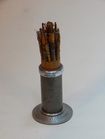
 Albert Park-South Melbourne Rowing Club
Moore Sculling Machine
"Grace Blake’s conversations with older members of the Club have elicited the following information during July 2014: • Don Christie recalls the machine being acquired by (or donated to) SMRC in the 1960s. SMRC later donated it to APRC. • Bob Duncan remembers it being at APRC. • Max Shaw joined the club in 1946 but doesn’t recall it at all. • Peter Watson recalls collecting the rowing machine from the old APRC club house before its demolition (c. 1995). The AP-SMRC machine carries a ‘maker’s plate’ with the name Moore... Moore Crane and Engineering Company Pty Ltd was a subsidiary of Malcolm Moore Industries Ltd whose manufacturing engineering works were located on Williamstown Road, Port Melbourne from 1927. The founder established the main business in 1921 and retired in 1953.21 The business was delisted from the Australian Stock Exchange in 1976. Grace Blake advises that some of the earlier SMRC members were plumbers and therefore worked in trades connected with engineering. She reports that Peter Watson recalls some of his contemporaries completing their engineering apprenticeships at Malcolm Moore Industries Ltd in the 1970s. There are still many unanswered questions concerning the history and provenance of the rowing machine at the time of writing this report, but the connection with a local engineering works is certainly fascinating. Questions to explore in the future include: Did Moore manufacture the machine, or import it (and perhaps assemble it) under licence? Was this machine a ‘one-off’ or did Moore make / distribute others within Australia? When, why and how did SMRC acquire the machine? Why did SMRC decide not to retain it, but to pass it over to APRC? And how did APRC use it?" 2014 Significance Assessment, pp38-40. "The ‘Moore’ Rowing Machine at the Albert Park – South Melbourne Rowing Club (AP- SMRC) is a rare example in Australia of the Kerns patent design from 1900. This machine may not, however, be that old in construction or use. The AP-SMRC machine is almost intact, appearing to lack only the leather straps for fastening the rower’s feet to the foot-rests. Spalding manufactured the design in the USA in the early decades of the 20th century, but the metal elements in its models are traditionally black. The bright red paint on the AP-SMRC machine suggests something different. The AP-SMRC machine carries a maker’s plate that associates it directly with a local engineering business, Malcolm Moore Industries Ltd of Williamstown Road, Port Melbourne. Club members recall the machine being at the South Melbourne Rowing Club in the 1960s, and being transferred at a later date to the Albert Park Rowing Club. The machine has not been used since the founding of the amalgamated AP-SMRC and requires careful conservation. The ‘Moore’ rowing machine is of national research significance as a rare survivor, in Australia, of the well-regarded Kerns patent design that was popularised by Spalding in the northern hemisphere. The English River and Rowing Museum website quotes a testimonial from an AG Spalding & Bros’ Mail Order Catalogue: ‘This machine was described by ‘an experienced oarsman’ ... “to be the most perfect rowing machine ever produced”. A feature was the adjustment of the resistance so “the weaker sex can use the machine”’. Its historic significance lies in its rarity (and perhaps uniqueness) as an aid to the training of rowers at two successful clubs on Albert Park Lake. Additional historic significance lies in the connection that the rowing machine represents between local rowing clubs and a major local manufacturing engineer. The ‘Moore’ rowing machine bridges the realms of innovation and application, of industry and recreation, of land-based and aquatic sports, and of two neighbouring rowing clubs on the Albert Park Lake." 2014 Significance Assessment, p43"A rowing machine that appears to be built to the Kerns patent design from 1900 but may not be that old in construction or use. The machine is heavy and includes parts made from cast iron. The cast iron components are painted in a distinctive bright red. The wooden seat moves on timber slides. Resistance is created by spring mechanisms at the ends of two frame elements that connect with two wooden ‘oars’, and by the central chain-driven system that co-ordinates with the rower’s movements. The machine carries a maker’s plate with the single word ‘Moore’ in an oval design, using white letters against a navy background, fastened to the base board and close to the foot-rests." 2014 Significance Assessment, p38Moorerowing, apsm rowing club, significance assessment, malcolm moore industries ltd, kerns, 1900, sculling machine, albert park rowing club, south melbourne rowing club, albert park lake, rowing machine, ergo -
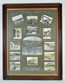 National Wool Museum
Photograph - Construction of Dennys Lascelles Austin & Co's Reinforced Concrete Wool and Grain Stores, Geelong, Edward Giles Stone, 1910-1912
Through improvements in productivity after 1095, Dennys, Lascelles, Austin and Co. determined to expand and engaged the Sydney-based engineer Edward Giles Stone. The resulting Bow Truss Building was claimed as being the largest flat-roof space in the world (almost an acre) without visible support. The Bow Truss Building was demolished amid a blaze of publicity in May 1990.Collage of 15 photographs mounted in a grey/brown cardboard backing depicting various stages of construction of wool & grain stores. Wooden frame.Wording: Dennys Lascelles Austin & Co. 1910-11;Location: Top centre Wording: G.C. Wilmot Photo Geelong;Location: Bottom right cornerdennys, lascelles, austin, construction, grain, wool, building, geelong, architecture -
 Port Fairy Historical Society Museum and Archives
Photograph
Showing the flood waters of 1946 around the Band Rotunda in the botanical gardens. Funding for the construction of the Rotunda was bequeathed in the Will of local resident Mrs Annie Williams, who was born in Daylesford in 1872 and died in Kew in 1930. Annie’s Will stipulated that the remaining value of her Estate be spent on erecting a Bandstand in the Port Fairy Botanical Gardens dedicated to the memory of her brother Hugh, a stretcher bearer in WW1 and who died in 1921 after being discharged with health issues, her husband Henry, and herself naturally. There is a plaque dedicated to Annie on the Bandstand She requested that the Bandstand be a replica of the one at Daylesford but by 1933 the value of her Estate had diminished to £76.4/8 which was insufficient to cover a similar design and the Borough Councillors felt it would be too extravagant for the Port Fairy Botanical Gardens. Local builder J.J.McLaren’s tender of £71.15/- was accepted and the octagonal concrete pillared construction was completed with the use of sustenance labour the following year. The Bandstand was opened in December, 1934 with a performance by the Port Fairy Band and local residents enjoying the entertainment and a picnic. In 1934 it was reported that there was some fuss in Council because of the whereabouts of the sum of approximately £3/- , being the amount left over from the build. After some months of debate, in which the Councillors suggested that the Engineer had used the money inappropriately, and to which he responded that the build had cost more than the quote, the matter seems to have ended there An image of the flood waters in the botanical gardens in 1946Black and white photograph of Flood water around rotunda in the gardensflood, river, botanical gardens, port fairy, moyne river, rotunda, bandstand -
 National Communication Museum
Souvenir - Souvenir cable, 1960
Construction on the Sydney Melbourne coaxial cable began in 1960 and was one of Australia's biggest and most important telecommunications projects of the 20th century. The laying of a coaxial cable between Sydney, Canberra and Melbourne, allowed people to direct dial long distance phone calls (rather than operator assisted), and supported simultaneous television broadcasts for the first time. It was officially opened on 9 April 1962 by the then Prime Minister, Sir Robert Menzies. This souvenir coaxial cable was presented to Mr Roy Kerr on his retirement. Mr Kerr was the Assistant Chief Engineer, Headquarters Customer Networks Branch, Telecom Australia.This cable has strong historic significance as part of the historic and technologically important Sydney-Melbourne coaxial cable. The cable represents not only a feat of technology but a shift in social engagement with telecommunication technologies, as it allowed people to direct dial long distance phone calls (rather than operator assisted), and supported simultaneous television broadcasts for the first time; it put the power of connection directly into the hands of the Australian public. This souvenir length of cable is well provenanced, and the details of the cables use and significance is inscribed on the steel casing. A 6 tube copper coaxial cable with lead sheath, quad 20lbs conductor cable (paper insulated), and a presentation metal collar and base. Inscriptions around the top of the metal collar and the base. "OLYMPIC CABLES PTY. LTD / AUSTRALIA" "6 TUBE COAXIAL CABLE / WITH 32 PAIRS 20LBS/MILE UNARMOURED / SYDNEY MELBOURNE 1960"coaxial cable, cable, sydney-melbourne coaxial cable, telstra, postmaster general's department (pmg), telecommunications, subscriber trunk dialling (std), television, telephone -
 Port Fairy Historical Society Museum and Archives
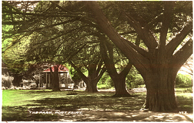
Postcard, The Park Port Fairy
Funding for the construction of the Rotunda was bequeathed in the Will of local resident Mrs Annie Williams, who was born in Daylesford in 1872 and died in Kew in 1930. Annie’s Will stipulated that the remaining value of her Estate be spent on erecting a Bandstand in the Port Fairy Botanical Gardens dedicated to the memory of her brother Hugh, a stretcher bearer in WW1 and who died in 1921 after being discharged with health issues, her husband Henry, and herself naturally. There is a plaque dedicated to Annie on the Bandstand She requested that the Bandstand be a replica of the one at Daylesford but by 1933 the value of her Estate had diminished to £76.4/8 which was insufficient to cover a similar design and the Borough Councillors felt it would be too extravagant for the Port Fairy Botanical Gardens. Local builder J.J.McLaren’s tender of £71.15/- was accepted and the octagonal concrete pillared construction was completed with the use of sustenance labour the following year. The Bandstand was opened in December, 1934 with a performance by the Port Fairy Band and local residents enjoying the entertainment and a picnic. In 1934 it was reported that there was some fuss in Council because of the whereabouts of the sum of approximately £3/- , being the amount left over from the build. After some months of debate, in which the Councillors suggested that the Engineer had used the money inappropriately, and to which he responded that the build had cost more than the quote, the matter seems to have ended there Coloured photograph (hand tinted) of the stand of cypress trees leading to the rotundaThe Park, Port Fairy - No. 3botanical, garden, cypress, tree, rotunda -
 Port Fairy Historical Society Museum and Archives
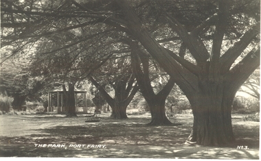
Postcard, "The Park", Port Fairy
Funding for the construction of the Rotunda was bequeathed in the Will of local resident Mrs Annie Williams, who was born in Daylesford in 1872 and died in Kew in 1930. Annie’s Will stipulated that the remaining value of her Estate be spent on erecting a Bandstand in the Port Fairy Botanical Gardens dedicated to the memory of her brother Hugh, a stretcher bearer in WW1 and who died in 1921 after being discharged with health issues, her husband Henry, and herself naturally. There is a plaque dedicated to Annie on the Bandstand She requested that the Bandstand be a replica of the one at Daylesford but by 1933 the value of her Estate had diminished to £76.4/8 which was insufficient to cover a similar design and the Borough Councillors felt it would be too extravagant for the Port Fairy Botanical Gardens. Local builder J.J.McLaren’s tender of £71.15/- was accepted and the octagonal concrete pillared construction was completed with the use of sustenance labour the following year. The Bandstand was opened in December, 1934 with a performance by the Port Fairy Band and local residents enjoying the entertainment and a picnic. In 1934 it was reported that there was some fuss in Council because of the whereabouts of the sum of approximately £3/- , being the amount left over from the build. After some months of debate, in which the Councillors suggested that the Engineer had used the money inappropriately, and to which he responded that the build had cost more than the quote, the matter seems to have ended there Black and white photograph of the stand of cypress trees with the rotunda in the backgroundThe Park Port Fairy - No 3botanical, garden, trees, rotunda, path -
 Port Fairy Historical Society Museum and Archives
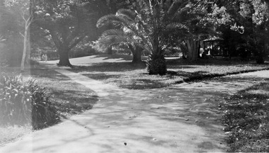
Photograph
Funding for the construction of the Rotunda was bequeathed in the Will of local resident Mrs Annie Williams, who was born in Daylesford in 1872 and died in Kew in 1930. Annie’s Will stipulated that the remaining value of her Estate be spent on erecting a Bandstand in the Port Fairy Botanical Gardens dedicated to the memory of her brother Hugh, a stretcher bearer in WW1 and who died in 1921 after being discharged with health issues, her husband Henry, and herself naturally. There is a plaque dedicated to Annie on the Bandstand She requested that the Bandstand be a replica of the one at Daylesford but by 1933 the value of her Estate had diminished to £76.4/8 which was insufficient to cover a similar design and the Borough Councillors felt it would be too extravagant for the Port Fairy Botanical Gardens. Local builder J.J.McLaren’s tender of £71.15/- was accepted and the octagonal concrete pillared construction was completed with the use of sustenance labour the following year. The Bandstand was opened in December, 1934 with a performance by the Port Fairy Band and local residents enjoying the entertainment and a picnic. In 1934 it was reported that there was some fuss in Council because of the whereabouts of the sum of approximately £3/- , being the amount left over from the build. After some months of debate, in which the Councillors suggested that the Engineer had used the money inappropriately, and to which he responded that the build had cost more than the quote, the matter seems to have ended there Black and white photograph of gardens with dividing paths and palm treebotanical, rotunda, gardens, trees, bandstand -
Friends of Ballarat Botanical Gardens History Group
Work on paper - Ballaarat Botanical Ferneries, Tradition and History, c. 2003
The Fernery in the Ballarat Botanical Gardens started as an ornamental shelter house of timber construction in 1876 with further extensions being made over the next decades.The tradition of a Fernery in the Botanical Gardens is important historically because of Its location as the focus at the northern end of the formal Gardens and, as an attraction and part of Ballarat's Victorian heritage.31/2 pages of print in large font with some italics throughout.None.john garner, doctor, john garner collection, ballarat botanical gardens, friends of ballarat botanical gardens, fernery, valentine lohse, ballarat city engineers' office, james veitch, gardenesque, "fern mania"., george longley, gardens, ballarat -
 Melton City Libraries
Map, Streets of Melton, 1963
MELTON’S STREETS Heritage Week 2014 What’s in a Name? Alphabetical List Aboriginal place names, Early Family Names and landowners, Agricultural, Shop and Commercial premises, Places and Events Melton & District Historical Society Street Naming Project 1972 – c 1998 Suburb Name – KURUNJANG - Kirkton, 1972, Brookfield, West, 1988 Melton and Town Centre - A joint collaboration with the Shire of Melton and Subdivision Developers ARNOLD Court – Family house - Arnolds Creek ALKEMADE Drive Family – Lime kilns Coimadia ALEXANDRA Street 1902 – Corination of King Edward VII and Queen Alexandra AVIATOR Place Event, location of plane crash – Jimmy Melrose 1936 Adina ?Annibee - Anniba? Agricultural Avon court .. .. BAKERY Square - Location of Jongebloed shop, bakehouse and stables BALUK Place Aboriginal BARLEYCORN Place Agricultural BILLING Place Name of Jimmy Melrose Uncle Noel Pemberton Billing BLACKWOOD Drive - Alexander Blackwood 1860c Registrar BARRIES Road C. E. Barrie “Darlingsford” farmer 1911, chaff mill owner BROOKLYN Road Staughton family residence. 1875 – Dismantled c 193? CAHILL Drive Family - Glenville Dairy CAMERON Court Family Canopus Place ? CANALLAN Drive Early Surveyor CAMPBELL Court Aviation – Melrose passenger 6th July 1936 CARBERRY Drive Michael, early landowner family CAREW Court Edward and Michael. Royal Hotel. Vera (Carew) Forran Singer - Opera CASEY Court Family CASHIN Court Family CHEVIOT Court Agriculture, breed of sheep CHESNEY Road was re named ( Minns Road being duplicated c 1973) CHRISTINA Crescent Christina McPherson, daughter of James and Mary Mary McPherson. Died 1955 aged 85 years COLLYER Close a deleted street (parallel to Yuille) re-used CORRIEDALE Road Breed of sheep CORR Court Teacher at first school, landowner CROXTON Court Name of the Hornbuckle and Knox family home DALEY Court - William Daley and family 1865 Bootmaker High Street DARLINGSFORD Boulevard - Name of early homestead Thomas B Darling 1853 DJERRIWARRH Court - Parish County of Bourke - very early map. DODEMAIDE Place Early land owners - Melton Football Team had 6 brothers playing c 1924 DONALD Court McPherson family 6 generations in Melton in 1936 DOUGAL Court DUNCAN Court .. .. DUNVEGAN Circuit Home of the McPherson family, castle Isle of Skye Name of bluestone house Smith Street (now at Willows) EMIL Court Jongebloed family EXELL Avenue Farming family Melton Sth- Closer Settlement 1907 EXFORD Road Exe former name of the Werribee river FARMER Court Name of early postmistress FERRIS Road John Ferris Farmer HANNAH Close First name of Hannah Watts – midwife HAYBALE Place Agricultural HELDER Court Early surveyor J Helder Wedge map HEWSON Street Winston Hewson Shire Engineer – check title c 1960 HENRY Street Township map c 1860 HESTON Street Heston Phoenix – C.J. Melrose plane HILDEGARDE Court Jimmy Melrose’s mothers name HOMESTEAD Close HORNBUCKLE Cres Farmers. Three members of family - Shire Presidents HURLEY Street Farmers IAIN Court Descendent of James and Mary McPherson JAMES MELROSE Drive Name appears on 2013 Melton information map JANG Place KURUN – jang KIRKTON Drive Name of the McPherson family home Toolern Vale Road KIRWIN Street Michael early landowners (deleted for freeway construction) KILPATRICKS Road Deleted when Barries Road was extended across Station Rd KOROROIT Court Early map, Parish of Kororoit. Creek name KNOX Circuit Family – Hornbuckle “Croxton Park” KURRUNJANG Drive Aboriginal name for people of the red earth – Suburb name Lara Place ? LLOYD Court Garage owners High Street. Laura lived to 100 years D 1955 LUBY Court John Luby – Crown Grant Land Title LITTLE Court MANNING Avenue Richard, hotel owner 1891 MARGARET Drive McPherson family McDONALD Street Melton South family name McKENZIE Street Township c1860 MORROW Street Early name MOWBRAY Crescent Name of English Melton, popularly believed origin of Melton MYERS Court Early setters c 1866 Crown Grant Land Title NIMMO Street Early name NIXON Street Name submitted by Mary nee Nixon Collins c1985 OLDERSHAW Road Early builder PALMERSTON Street Early township map c 1860 PEART Court Early name PENNYROYAL Avenue Plant growing by the creek. Early name used for the Toolern Toolam Creek PINKERTON Street Family name and early street map PINNACLE Crescent Agricultural - type of wheat PHOENIX Circuit C.J. Melrose Phoenix Heston Plane 2013 map PRATT Family PRIOR Court PYKE Place Brothers – early settlement 1838 RADFORD Court Land owners and business operators. Former Royal Hotel Grocer High Street demolished 1970 RAGLAN Court Hotel 19th century Lord Raglan RALEIGHS Road Oliver Reierson family (Norweigen) Shopkeeper – Dressmakers RIDDELL Drive (misspelt Riddle) Resident and land owner RODERICK Road McPherson family – a re occurring name ROLLAND Court Jones family ROSS Court Daniel. Landowner. Agnes Ross music teacher RUSSELL Court Robert. Early land surveyor of Melton 1853 RYAN Court Family early landowner. Member of the 1862 Road Board SHEBLER Place Augustus early Melton resident – Golden Fleece Hotel SHEEPFOLD Court Farming SHERWIN Court Sherwin Street earliest Township map– became Golf course SMITH Street Early township map. STRATHULLOH Circuit Strathtulloh Homestead. STAUGHTON Street Family – LARGE land owners Strachan ? SWANEY Court Marie Swaney earlier resident of Strathtulloh. SUTHERLAND Family name TOOLERN Street TOOLAM – TOOLERN Creek TULLIDGE St Road marked on 1861 map UNITT Street Early Township c 1860 WALLACE Square Cr Jack Wallace 5 terms as President 46 years unopposed WATTS Court Hannah Watts – midwife, cottage hospital WALSINGHAM Name of house of Minns family. From Walsingham Norfolk England WESTLEY Place Name of Jimmy Melrose Percival Gull Plane WESTLAKE Drive Early resident WHICKHAM Street Family Name Melton South WILSON Road Albert, Melton South YUILLE Street William Cross, early landowner, Rockbank run Zoomed in section of Melton Streets including Church and High Streetlandscapes of significance -
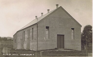 Harcourt Valley Heritage & Tourist Centre
postcard, A N A Hall, Harcourt, 1915
Harcourt branch of the Australian Natives Association was formed in 1908, meeting in a chaff shed behind the local grocer shop. In 1911 the branch contracted with Mr Sutherland of Barkers Creek to build a hall of boxed concrete construction. Sutherland was a pioneer in the use of concrete for structural purposes.He subsequently had a career as City Engineer at Camberwell. The ANA branch conducted many social occasions in the hall and gave community leadership for upwards of fifty years in addition to its friendly society/health insurance activities.. This was the only community hall in the Harcourt community until it was superseded by the Harcourt Leisure Centre in 1991 It is now the home of Harcourt Heritage Centre.A community hall of pioneering construction method, provided to the community by a friendly society.black and white postcard depicting a community hallA N A Hall, Harcourt -
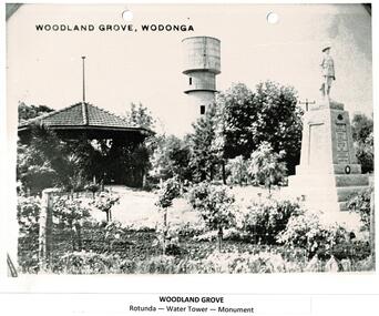 Wodonga & District Historical Society Inc
Photograph - Codling Collection 01 - Woodland Grove, Wodonga
Miss Olive Codling was a Foundation Member and a Life Member of the Wodonga Historical Society. Many of her prize-winning photos are held in the Society Collection. She also held a range of roles and committee positions in a wide range of Wodonga community organisations. These included the Horticultural Society, the Wodonga Arts Council, the Wodonga Camera Club and the Wodonga Lapidary Club. Woodland Grove is located in the triangular reserve at the corner of High and Hovell Streets, Wodonga. ‘Woodland Grove". It was named in honour of John Woodland at the same time as the opening of the band rotunda in September 1920. John Woodland, Wodonga Shire’s first president, was born in Kent, England, in 1829 and came to Sydney with his parents in 1839. He arrived in the Wodonga district about 1853, where he created a successful carrier's business. He first lived on the Old Barnawartha Estate and a few years later purchased land at Green Hills, Wodonga West, where he farmed and also ran a hotel. The hotel licence was relinquished to give attention to duties as secretary and clerk of works to Wodonga Shire, which was then the Wodonga Riding of the Shire of Yackandandah. He was a main agitator for the separation of Wodonga district from Yackandandah Shire. This was successful in 1876, and he became the first president of Wodonga Shire. He held this post for two years, then taking on the role of shire secretary in 1878 until 1913. He concurrently undertook the role of clerk of works (engineer) from 1896 to 1907. As clerk of works he prepared the plans and specifications for, and supervised the construction of the big bridges on the Albury road and at Bonegilla and other important works. In his mid 70s, he proffered his resignation on a number of occasions but it was not accepted. Despite physical weakness and impaired vision, John continued his duties to the end, with the help of his daughter Rose Murphy. Rose became shire secretary for 20 years after her father’s death in 1913.This photo collection is significant as it documents the naming of a public area in Wodonga to honour an original and long-serving member of the Wodonga Shire Council.A black and white photo of Woodland Grove in High Street, Wodonga. It includes the rotunda, the water tower and the soldier's memorial. There is a post and wire fence in the foreground as well as several trees and rose bushes. Beneath the photo: "WOODLAND GROVE / Rotunda - Water Tower - Memorial"high st wodonga, woodland grove, john woodland -
 Wodonga & District Historical Society Inc
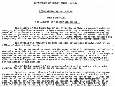
Album - Hume Reservoir Australia Album - Introduction - Part 1, Department of Public Works, N.S.W, 1927
This set of photos is from a leather bound album bearing the inscription "HUME RESERVOIR AUSTRALIA" plus 'The Rt. Hon. L. C. M. S. Amery, P. C., M .P.' all inscribed in gold. It was presented to The Rt. Hon. L. C. M. S. Amery, P. C., M. P, Secretary of State for Dominion Affairs on the occasion of his visit to the Hume Reservoir on 2nd November 1927. This album is of local and national significance as it documents the planning and development of the Hume Reservoir up to 1927. It was the largest water reservoir in the British Empire. The album records the pioneering engineering work that went into its construction.RIVER MURRAY WATERS SCHEME, HUME RESERVOIR THE LARGEST IN THE BRITISH EMPIRE. ' The history of the inception of the River Murray Waters Agreement under the terms of which the Hume Reservoir is being constructed, the purposes of the work, its correlation to the other works on the Murray and the methods of construction are all outlined in the attached article entitled “The River Murray Waters Scheme, the Nile of Australia”, by Mr H.H. Dare, M.E., M.Inst.C.E., Commissioner, Water Conservation and Irrigation, and the New South Wales Representative on the River Murray Commission. The article was published in 1925 and some alterations brought about by the efflux of time are necessary. As far as personnel is concerned, the death of Mr J.S. Dethridge, M.Inst.C.E., removed a very able engineer from the councils of the Commission. His place as Representative of Victoria has been taken by Mr R. Horsfield. It is also to be regretted that ill-health has caused the retirement of Mr E.M. de Burgh, M.Inst.C.E., the eminent Chief Engineer for New South Wales, who, with Mr Dethridge, was largely responsible for the Agreement cemented by the River Murray Waters Acts and, inter alia, for the design of the Hume Dam. The following summary of the progress of work on the Locks might be substituted for the latter part of Mr Dare’s paragraph. Up to the present time six locks and weirs have been completed, the highest in the series being at Torrumberry and the lowest at Blanchetown. Locks No.26 at Torrumberry and No.11 at Mildura were built by Victoria and are in use. A lock and weir (No.10) is in progress at Wentworth, and the necessary camp arrangements, purchase of plant, etc., have been undertaken in connection with lock and weir No.15 at Euston, both under the direction of New South Wales. Lock No.9, which forms part of the Lake Victoria Scheme, Lock No.5 at Renmark and Lock No.3 in South Australia hume reservoir australia, river murray waters scheme -
 Wodonga & District Historical Society Inc
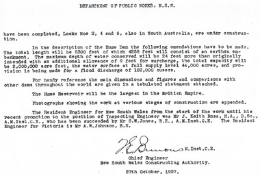
Album - Hume Reservoir Australia Album - Introduction - Part 2, Department of Public Works, N.S.W, 1927
This set of photos is from a leather bound album bearing the inscription "HUME RESERVOIR AUSTRALIA" plus 'The Rt. Hon. L. C. M. S. Amery, P. C., M .P.' all inscribed in gold. It was presented to The Rt. Hon. L. C. M. S. Amery, P. C., M. P, Secretary of State for Dominion Affairs on the occasion of his visit to the Hume Reservoir on 2nd November 1927. This album is of local and national significance as it documents the planning and development of the Hume Reservoir up to 1927. It was the largest water reservoir in the British Empire. The album records the pioneering engineering work that went into its construction.DEPARTMENT OF PUBLIC WORKS, N.S.W. (continued from previous image). have been completed, Locks Nos. 2, 4 and 6, also in South Australia, are under construction. In the description of the Hume Dam the following emendations have to be made. The total length will be 5,300 feet of which 4,258 feet will consist of an earthen embankment. The maximum depth of water conserved will be 24 feet more than originally intended with an additional allowance of 9 feet for surcharge, the total capacity will be 2,000,000 acre feet, the water surface at full supply level 44,000 acres, and provision is being made for a flood discharge of 182,000 cusecs. For handy reference, the main dimensions and figures and comparisons with other dams throughout the world are given in a tabulated statement attached. The Hume Reservoir will be the largest in the British Empire. Photographs showing the work at various stages of construction are appended. The Resident Engineer for New South Wales from the start of the work until his recent promotion to the position of Inspecting Engineer was Mr J. Keith Ross, M.A., B.Sc., A.M.Inst.C.E., who has been succeeded by Mr S.W. Jones, B.E., A.M.Inst.C.E. The Resident Engineer for Victoria is Mr A.W. Johnson, B.E. (Signed) M. Inst.C.E. Chief Engineer New South Wales Constructing Authority 27th October 1927. hume reservoir australia, river murray waters scheme