Showing 1315 items
matching growth
-
 Kew Historical Society Inc
Plan - Subdivision Plan, Winton Estate, East Kew : Sale of 10 Building Blocks, 1920
The Kew Historical Society's map collection includes a substantial number of real estate subdivision plans, mainly of Kew but also of surrounding suburbs in Melbourne. Most of the subdivision plans date from the 1920s and 1930s when the districts old homes and local farmland were being split up to accommodate residential growth in the postwar period. These early plans were assembled by a local firm, Jas R Mather & McMillan, which had an office in Cotham Road. Many of the plans, and sometimes photos, were annotated by the agents.Subdivision plans are historically important documents used as evidence for the growth of suburbs in Australia. They frequently provide information about when the land was sold as well as evidence relating to surveyors and real estate and financial agents. The numerous subdivision plans in the Kew Historical Society's collection represent working documents, ranging from the initial sketches made in planning a subdivision to printed plans on which auctioneers or agents listed the prices for which individual lots were sold. In a number of cases, the reverse of a subdivision plan in the collection includes a photograph of a house that was also for sale by the agent. These photographs provide significant heritage information relating house design and decoration, fencing and household gardens.The photograph may also be aesthetically significant depending on the importance of the photographic atelier.Subdivision plan for the so-called Winton Estate in East Kew. The Estate comprised 10 lots facing Simpson Street and Campbell Street. The estate was auctioned by Jas. R. Mathers, Son and McMillan. campbell street, simpson street, hunter street, normanby road - kew, subdivision plans - east kew, subdivision plans - kew -
![7 Roomed Brick [villa]; Modern Conveniences](/media/collectors/550653872162f11fb04854aa/items/59ec3da221ea690fdc4ba793/item-media/59ec3ee521ea690fdc4d0c37/item-fit-380x285.jpg) Kew Historical Society Inc
Kew Historical Society IncPhotograph - 7 Roomed Brick [villa]; Modern Conveniences, 1920s
The Kew Historical Society's map collection includes a substantial number of real estate subdivision plans, mainly of Kew but also of surrounding suburbs in Melbourne. Most of the subdivision plans date from the 1920s and 1930s when the districts old homes and local farmland were being split up to accommodate residential growth in the postwar period. These early plans were assembled by a local firm, Jas R Mather & McMillan, which had an office in Cotham Road. Many of the plans, and sometimes photos, were annotated by the agents.Subdivision plans are historically important documents used as evidence for the growth of suburbs in Australia. They frequently provide information about when the land was sold as well as evidence relating to surveyors and real estate and financial agents. The numerous subdivision plans in the Kew Historical Society's collection represent working documents, ranging from the initial sketches made in planning a subdivision to printed plans on which auctioneers or agents listed the prices for which individual lots were sold. In a number of cases, the reverse of a subdivision plan in the collection includes a photograph of a house that was also for sale by the agent. These photographs provide significant heritage information relating house design and decoration, fencing and household gardens.The photograph may also be aesthetically significant depending on the importance of the photographic atelier.A professionally produced photograph for a local real estate agent, probably Jas. R. Mathers, Son & McMillan. The photograph is of a Federation-era bungalow, in Kew. The photo is on the reverse of a subdivision plan for the Normanby Heights Estate, Kew.The mount on which the photograph is placed includes: "Kew. 1 minute to tram. Good Position. / 7 roomed brick. Modern conveniences. / Land 60 x 135. 1100 pounds"real estate photographs, houses - kew, federation architecture -
 Kew Historical Society Inc
Plan - Subdivision Plan, Argyle Road, Heather Grove, Victor Avenue, Kew, c.1937
The Kew Historical Society's map collection includes a substantial number of real estate subdivision plans, mainly of Kew but also of surrounding suburbs in Melbourne. Most of the subdivision plans date from the 1920s and 1930s when the districts old homes and local farmland were being split up to accommodate residential growth in the postwar period. These early plans were assembled by a local firm, Jas R Mather & McMillan, which had an office in Cotham Road. Many of the plans, and sometimes photos, were annotated by the agents.Subdivision plans are historically important documents used as evidence for the growth of suburbs in Australia. They frequently provide information about when the land was sold as well as evidence relating to surveyors and real estate and financial agents. The numerous subdivision plans in the Kew Historical Society's collection represent working documents, ranging from the initial sketches made in planning a subdivision to printed plans on which auctioneers or agents listed the prices for which individual lots were sold. In a number of cases, the reverse of a subdivision plan in the collection includes a photograph of a house that was also for sale by the agent. These photographs provide significant heritage information relating house design and decoration, fencing and household gardens.The photograph may also be aesthetically significant depending on the importance of the photographic atelier.Undated blue subdivision plan in Kew of 14 lots facing Argyle Road, Heather Grove and Victor Road. The Plan identifies Tuxen & Miller as the surveyors. [Formerly catalogued as MAP.0059]subdivision plans - kew, argyle road - kew, heather grove - kew, victor avenue - kew -
 Emerald Museum & Nobelius Heritage Park
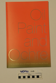
Book, Yarra Ranges Regional Museum, Oil Paint and Ochre, The incredible story of William Barak and the de Purys, 2015
This book tells the story of William Barak and the de Pury family, where descendants of both sides still live today. It also has national significance as a story that explores the complex, first generation negotiations between Aboriginal and European people. Also the establishment of Coranderrk Aborignal Station at Healesville and the growth of the wine industry in the Yarra Valley. William Barak was a Wurundjeri leader and the de Purys' were a wine making family. The book complemented and exhibition called Oil Paint and Ochre 29 Aug - 22 Nov 2015.Soft cover paperbackwilliam barak, de purys, corranderk -
 Warrnambool and District Historical Society Inc.
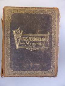
Book, Victoria & Its Metropolis Vol 1 & 2, 1888
These two volumes are seminal historical writings published in 1888. The author of Volume One is Alexander Sutherland (1852-1902), described as ‘a forgotten Australian intellectual’. Born in Scotland, Sutherland was a teacher, poet, biographer, novelist, scientist, philosopher and journalist. In 1902 he was the Registrar of Melbourne University and he was the Secretary of the Royal Society of Victoria. With his brother, George, he wrote a history of Australia and New Zealand which sold 100,000 copies, the first best-selling Australian history. His book, ‘The Origin and Growth of the Moral Instinct’ influenced Russian philosophical thought. This is a most significant book as it contains short biographical notes on a great number of early (19th century) residents of the Warrnambool district. As well as listing information on Warrnambool identities it includes information on residents of Purnim, Wangoom, Dennington, Panmure, Garvoc, Framlingham, Winslow, Yangery, Woodford, Mailors Flat, Grasmere, Bushfield and Allansford. It is a great resource for researchers today. The two volumes also contain illustrations pertaining to the areas around Warrnambool and are of great historical as well as artistic interest. These are two volumes of ‘Victoria and Its Metropolis’. They are leather bound with a black cover, heavily ornamented in gold around the edges of the cover and with the printed material also in gold lettering in an ornamental pattern. The spine of the covers are brown with gold ornamental patterns and printing. Volume One has 594 pages with 258 illustrations , all black and white and this volume contains writings on the early days of the colony up to 1888 and chapters on the arts, churches, education, industries, science etc. in Victoria. Volume Two has 822 pages with many black and white illustrations and chapters on the regions in Victoria and biographical notes on the pioneer settlers of these districts. Both volumes are in a very tattered condition with many loose pages and the leather binding much torn and with some parts missing. Volume One cover: ‘Victoria and its Metropolis, Past and Present’ Volume One spine: ‘Victoria and its Metropolis, Vol. 1’ Volume Two Cover: ‘Victoria and its Metropolis, Past and Present’’ Volume Two Spine: ‘Victoria and its Metropolis, Vol. 2’ 19th century victorian history, victorian pioneer settlers, alexander sutherland -
 Kiewa Valley Historical Society
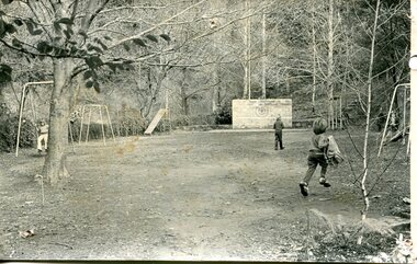
Photograph – black and white photograph of children playing in the school yard at Bogong Village Primary School, Circa late 1960s to early 1970’s
The early forties saw rapid growth of Bogong Village, with single and married men’s quarters, workshops, mess huts and administrative offices. The facilities necessary for communal living were quickly in place- a post office, police station, co-op store, medical centre, community hall/theatre, tennis courts and school. Bogong Primary School opened in 1941 to provide an education for the families of employees of the State Electricity Commission of Victoria. The school had up to date equipment and received glowing reports from school inspectors. It closed circa 1970.The Bogong State School was opened for the children of S.E.C.V. workers who lived in Bogong in a remote part of north east Victoria. The nearest school would have been 14 miles away and over mountain roads subject to heavy construction traffic and extremes of climatic conditionsBlack and white photograph of a group of 6 children playing on play equipment in the schoolyard at Bogong Primary School. The area is enclosed by tall trees in a bush-like settingbogong state school; secv; kiewa hydro electric scheme; -
 Federation University Historical Collection
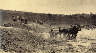
Book, Yallourn, 10/1962
In the foreword the Chairman and General Manager, W.H. Connolly, wrote: "Australia's progress since the Second World War has been remarkable - and nowhere more so than in Victoria. Although the smallest pf the mainland States, Victoria is today the most highly industrialised, the second most populous and the most rapidly developing State in the Commonwealth. Many factors have contributed to this growth, bu the one of greatest importance is the vast wealth of easily extractable brown coal in the Latrobe Valley which is the source of Victoria's electricity and a major part of its solid fuel. ... "White and green soft covered book of 34 pages with black & white and coloured illustrations. The book includes starts with an historical section, and includes information the open cut, Yallourn Power Station, Yallourn Briquette Works, the town, Morwell Open Cut, and includes a map of the Latrobe Valley Brown Coal resources.yallourn, connolly, open cut, power station, kernot, coal, briquette, lyle, monash, yallourn open cut, yallourn power station, yallourn briquette works, morwell open cut, hazelwood, brown coal, gippsland, horses, turning sod -
 Robin Boyd Foundation
Document - Manuscript, Robin Boyd, The Rich (In Art) Get Richer – and the culturally poor get poorer, 1963
Boyd argues that the Australian cultural split between what he perceives to be cultured tastes and artistic achievements and the tastes of ordinary Australians is wider and more polarised than in other countries. He derides commercial radio, popular women's magazines, public commercial streets etc - elements of the Australian ugliness. He praises the growth of local contemporary art, literary magazines and architecture, whilst calling for the development of community pride amongst leaders of commerce and industry, and government control of the ugliness of popular culture. This may have been published in "Walkabout" magazine.Typewritten (c copy), quarto, 11 pagesart, egalitarianism, sidney nolan, australian painting, pop art, phil may, dyson, low, media, cartoons, australian literature, radio, california cultural heritage board, commercial advertising, robin boyd, manuscript -
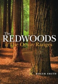 Otway Districts Historical Society
Book, Lothian Custom Publishing, The redwoods of the Otway Ranges. Roger Smith, January 2015
This book is the remarkable story of the world's tallest tree species, the Redwood, growing in the Great Otway National Park in Victoria's south-west. It was originally planted by Victorian foresters for experimental purposes on land abandoned by the early settlers. The Coast Redwood, native of California, is now thrives in the Otways alongside the famous eucalypt, the towering Mountain Ash. The majestic Otway Redwoods, still in their youthful growth phase, have withstood adversity caused by fire, landslide, lighting and chainsaws, while the ongoing political debate about the conservation of the valuable forest resources continues.The redwoods of the Otway Ranges. Roger B. Smith. Lothian Custom Publishing; Middle Park (Vic); 2015. ii, 202 p.; illus., maps, appendices, notes. IBSN 978 1 921737 13 8. Soft cover.With best wishes from Roger Smith. -
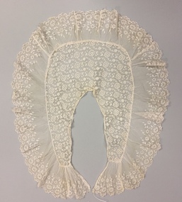 Kew Historical Society Inc
Clothing - Lace Pelerine, 1900s
The Fashion & Design collection of Kew Historical Society includes examples of textiles dating from the 18th, 19th and 20th centuries. Some of the textiles, were used as items of clothing, others as items of household decoration, or simply as travel souvenirs. These textiles were created both domestically and internationally. Predictably with the growth of an ethnically and culturally more diverse community in Kew after the Second World War, textiles, clothing and objects in the collection inevitably reflected this diversity. A pelerine is a small cape that covers the shoulders. It was most popular during the mid- to late nineteenth century. Cream net machine embroidered collar with ruffle of chemical lace. Machine constructed post World War 1. Worn in the evening women's clothing, lace, collars, pelerines -
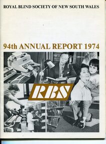 Vision Australia
Administrative record - Text, 94th Annual Report Royal Blind Society of N.S.W. (1974), 1974
Articles in the annual report include: death of General Manager Ian Burnet, expenditure exceeding income, need to sell Woolahra (Helen Keller hostel) property, goal of opening 20 new Day centres by the end of 1975, plans to establish Occupational Therapy Training unit, review of aging hostels and restructure workshop, growth of Mitchell Street Theatre, increase of children with more than sight loss at nursery, decision to establish reading competition in memorial to Barbara Rutherford and awarding of Churchill Fellowship to Joan Ledermann for a review of Braille production units overseas.1 volume of text and imagesroyal blind society of new south wales, corporation records -
 Eltham District Historical Society Inc
Photograph, Barnes Railway Station, Moama, NSW, November 1962
Barnes station building photographed in November 1962. The railway reached Echuca in 1864 and transformed the town into a major river port, with a famous wharf and substantial urban growth in the 1870s. In 1876 the Deniliquin and Moama Railway Company opened its 71 km (44 mi) private railway northwards to Barnes and Deniliquin, and the line at Echuca was extended across the Murray River into Moama to join the railway. This section was taken over by Victorian Railways in 1923, as part of the 1922 Border Railways Act. Barnes station was closed in 1979. Deniliquin railway line https://en.wikipedia.org/wiki/Deniliquin_railway_lineDigital TIFF file Scan of 35mm Ilford FP3 black and white negative transparencybarnes railway station, echuca, george coop collection, moama -
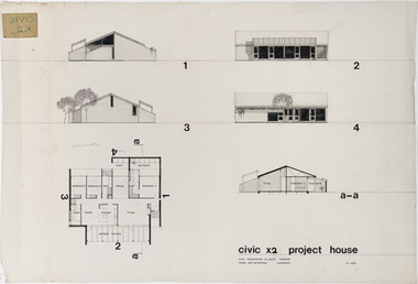 RMIT Design Archives
Architectural drawings, Civic x2 Project House
Robin Cocks (1941- ) and Peter Carmichael (1942 - ) formed their partnership in 1967, and designed some of Australia's most innovative project houses in the late 1960s and early 1970s. The award winning Civic Growth House (1974) was designed for Civic Construction. It provided clients with a modular grid and a range of components that allowed choice in location and spatial variation. The houses were designed to be expanded as families grew or as finance became available. The one-level Civic X2 was constructed in full-brick, included a pergola and deck, and a private courtyard off the main bedroom, This drawing includes floor plan, elevation and section.architecture, domestic architecture, project homes -
 Kew Historical Society Inc
Photograph - Cosy Five Roomed Rough Cast Bungalow, Kew, J E Barnes, c.1920
Subdivision plans are historically important documents used as evidence of the growth of suburbs in Australia. They frequently provide information about when the land was sold on which a built structure was subsequently constructed as well as evidence relating to surveyors and real estate and financial agents. The numerous subdivision plans in the Kew Historical Society's collection represent working documents, ranging from the initial sketches made in planning a subdivision to printed plans on which auctioneers or agents listed the prices for which individual lots were sold. In a number of cases, the reverse of a subdivision plan in the collection includes a photograph of a house that was also for sale by the agent. These photographs provide significant heritage information relating house design and decoration, fencing and household gardens. The photograph is also aesthetically significant as it was taken by J. E. Barnes, a nationally significant photographer. He was the most important photographer to have worked in Kew. He was active as a photographer in the district from c.1906 until his death in 1921. Best known as 'the Embarkation Photographer' (see the Australian War Memorial collection), Josiah Earl Barnes was also the official photographer employed by the Borough (and later Town, then City) of Kew. He clearly also completed commercial jobs for local businesses, as is the case in this photograph of a house for a local real estate and financial agent. A modest weatherboard house with rough-cast rendered walls. The gabled entrance incorporates elements of the Japanese aesthetic. The strong lines of the dark timber gable are reinforced by the colour and shape of the pickets in the fence. In contrast to an earlier period, the chimneys appear truncated. The use of extensive double-hung sash windows in the front rooms reflects a new interest in light in houses. The use of separate sunshades over windows in an earlier period is here replaced by an extension of the roofline over the window. The photographer Josiah Barnes died in 1921; so, the photograph of the house must predate this date. The location of the house, which was advertised for sale, has to date not been identified. Illegible inscription. Photographer's information on mount.josiah earl barnes, j e barnes, photography - kew, interwar housing - victoria, 1920s housing - kew -
 Kew Historical Society Inc
Photograph - 2 Young Street, Kew, Paramount Photos, 1920s
Subdivision plans are historically important documents used as evidence of the growth of suburbs in Australia. They frequently provide information about when the land was sold on which a built structure was subsequently constructed as well as evidence relating to surveyors and real estate and financial agents. The numerous subdivision plans in the Kew Historical Society's collection represent working documents, ranging from the initial sketches made in planning a subdivision to printed plans on which auctioneers or agents listed the prices for which individual lots were sold. In a number of cases, the reverse of a subdivision plan in the collection includes a photograph of a house that was also for sale by the agent. These photographs provide significant heritage information relating house design and decoration, fencing and household gardens.A prepossessing, large home constructed in the Arts and Crafts style. Located on the banks of the Yarra at 2 Young Street, Kew overlooking the factories of Richmond, the design of the house takes account of the gradient with the addition of a level below the front entrance. The elegant roof includes a number of projecting gables and dormers. The gables are typically half-timbered and rendered. In addition to the asymmetrically placed portico, there are at least two open verandas, supported by timber pillars and with roofs that reflect the overall pitch of the roof of the housereal estate photographs, 2 young street - kew -
 Kew Historical Society Inc
Photograph - 8 roomed DF Brick Villa, Kew, J E Barnes, c.1920
Subdivision plans are historically important documents used as evidence of the growth of suburbs in Australia. They frequently provide information about when the land was sold on which a built structure was subsequently constructed as well as evidence relating to surveyors and real estate and financial agents. The numerous subdivision plans in the Kew Historical Society's collection represent working documents, ranging from the initial sketches made in planning a subdivision to printed plans on which auctioneers or agents listed the prices for which individual lots were sold. In a number of cases, the reverse of a subdivision plan in the collection includes a photograph of a house that was also for sale by the agent. These photographs provide significant heritage information relating house design and decoration, fencing and household gardens. The photograph is of additional aesthetic significance as it was photographed by J. E. Barnes. Josiah Earl Barnes is a nationally significant photographer. He was also the most important photographer to have worked in Kew. He was active as a photographer in the district from c.1906 until his death in 1921. Best known as 'the Embarkation Photographer' (see the Australian War Memorial collection), J. Earl Barnes was also the official photographer employed by the Borough (and later Town, then City) of Kew. He clearly also completed commercial jobs for local businesses, as is the case in this photograph of a house for a local real estate and financial agent.A photograph, mounted on board of a double fronted Federation-era brick villa in Kew, photographed for a local real estate agent and financier by J. E. Barnes of Kew. On the reverse of the photograph is a subdivision plan for the Normanby Estate, East Kew - 2016.0039.1. As can be seen from the image, there is a large tear on the surface of the photograph.The brown card on which the photograph is mounted includes the following handwritten description, which may aid the identification of the house: "Kew, 3 minutes from tram, 8 roomed DF Brick Villa, tile roof including two attics, sleepout, bathroom, heater, E Light, Entrance Hall, double doors, leadlights, laundry, garden, lawns, land 75 x 170, 1975 pounds". Also photographers inscription on mount, lower left: J. E. Barnes / Photo / Phone 1966 Haw. KEW.j. e. barnes, josiah earl barnes, j. earl banes - photographer, architecture - federation style, houses - kew, real estate photographs -
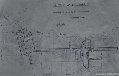 Melton City Libraries
Map, Melton Water Supply, Unknown
The development that had arguably the greatest impact in encouraging population growth in the shire during this period, was the establishment of a reliable water supply for the district. This had been a major concern of the local community for over 100 years, since the Melton township was first founded. Despite various schemes over the years to create a reliable water supply, the district was still dependent on bores, wells and tanks when the Melton Waterworks Trust was established in 1961 to address Melton’s water woes. With the opening of the Djerriwarrh Dam in December 1963, the shire’s residents finally had access to a reticulated water supply.Map shows the boundary of the area where the water will be serviced in the towncouncil -
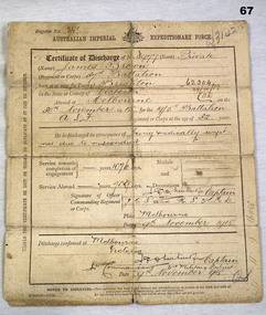 Bendigo Military Museum
Administrative record - CERTIFICATE OF DISCHARGE WW1, 9.11.1918
James BROWN No 5977 enlisted in the AIF in 19th reinforcements 5th Batt on 30.11.1915 aged 32 years 3 months. Embarked for England 27.7.1916, transfer to 37th Battalion 23.9.1916, hospitalised 9.10.1916 with Scabies. Rejoined unit 6.1.1917, allowed Regt No 5977A, embarked for France 25.2.1917. Hospitalised 16.3.1917 with Enteritis, rejoined unit 25.3.1917. Hospitalised 21.5.1917 with Debility, rejoined unit 1.6.1917. Hospitalised 14.6. 1917 with Exhaustion later as growth in groin. From here he gets himself into trouble. Hospitalised 24.12.1917 with Nephritis, discharged from the AIF 9.11.1918 medically unfit.Certificate of Discharge Register No 547 for James BROWN Regt No 5977 AIFdocuments - certificates, military history - army records -
 Phillip Island and District Historical Society Inc.
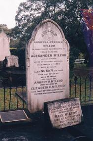
Photograph Album, Kodak, Phillip Island Cemetery, c 1889
The Album was compiled by Nancy McHaffie late 1990's, with the assistance of Edith Jeffery's, with her book "Garden of Memories" and extensive knowledge of Phillip Island. The Cemetery lies back from the road and is surrounded by Manna Gums, rare Peppermint Gums, Blackwoods and other native trees. In all 25 acres of land were set aside as Crown Land in the land settlement of 1868. There are 6.2 acres of wetlands near the cemetery entrance.Captain McLeod: Captain McLeod and family kept the Post Office at Newhaven. He also built a boat called old "Trusty" and launched it almost opposite Churchill Island. Unfortunately, at a later date, the "Trusty" was the cause of a tragedy. The bottom of the boat had become so encrusted with marine growth that the owner decided to beach her between the jetties at Griffiths point, now San Remo. Before the job was completed the soring gave way and allowed the boat to tip over on her side, causing Captain McLeod to be crushed to death. Died March 3rd 1880 aged 64 years. Also buried in this grave is his wife Susan - died May 24th 1882 aged 62 years. Their son Andrew McLeod died February 21st 1916 aged 60 - loved husband of Elizabeth E McLeod. Alexander was Captain of the "Genista" for 12 years.phillip island cemetery, captain alexander mcleod, susan mcleod, andrew mcleod, nancy mchaffie, edith jeffery -
 Ballarat Tramway Museum
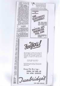
Newspaper, Ballarat Tramway Museum (BTM), Use Electricity sparingly, Oct.. 1995
Demonstrates the work done by the BTM/BTPS to celebrate the 50 years since the end of the Second World War and the documents prepared for the CHHA Exhibition in 1995.Six items illustrating operations of tramways in Ballarat during WWII, used in "Ballarat Trammies at War Exhibition" - Oct. to Dec. 1995. 254.1 - Part copy of page of Ballarat Courier with SEC ad to save electricity and War bonds - photocopied, laminated with 4 Velcro dots on rear. 254.2 - part copy of page of Ballarat Courier 2/7/1942 - re growth of tram traffic - as above. 254.3 - part copy of page of Ballarat Courier 14/2/1042 - re trams are black out - as above. 254.4 - retyped item of .2 on plastic film with orange paper glued to rear, used for pointer to .2 item with two Velcro dots. 254.5 - Note re item to be sent to overseas used in .3, as for .4, but on yellow paper. 254.6 - retyped item of .3 as for .4, but green paper. Images added 19/10/2013.trams, tramways, secv, ballarat tramways, world war ii -
 Bendigo Military Museum
Administrative record - Royal Australian Survey Corps Miscellaneous Documents Volume 57, Army Works Development Committee, Royal Australian Survey Corps Miscellaneous Documents Volume 57, 1967 1969, Item #18 1947
Sleeve #1 " Percentage of ARA recruits allocated to RA Svy entering 1 RTB having obtained leaving certificate or better education standard." Sleeve #2 "Report of Review Committee on RA Svy 17 Feb 1969." Sleeve #3 " Recommendation of the forming of the Army Mapping and Charting centre at Bonegilla." Sleeve #4 "Comparison Charts" "RA Svy Strength / Establishment 1960 - 1968." Top LHS. "3.134.4" Top RHS. Sleeve #5 "Report of RA Svy Review Committee. Recomends the forming of 2,4 and 5 Fd Svy Sqns and adding 8 Fd Svy Sqn to the Order of Battle" Sleeve #6 " Letter and Report as part of Review dealing with manpower." Sleeve #7 "AEC" 15 Oct 1969 Sleeve #8 "17 Sep 1969" Sleeve #9 "18 Dec 68" "3.134.2" Sleeve #10 "3.134.4" Sleeve #11 "12 Mar 69" 3.134.4" Sleeve #12 "10 Jun 69" "3.134,4" Sleeve #13 "Terms of Reference - Review Committee" Sleeve #14 "5 Feb 68" Sleeve #15 "Relocating Svy Regt at Bonegilla, Proposed Mapping Centre in Canberra" Sleeve #16 Comparison of rate of growth of ARA with RASvy Sleeve #17 A detailed analysis of RASvy's role by sub unit including overseas agencies. There is also a document describing the various Survey Trades. Sleeve #18 Letter from disgruntled farmer re damage to his property. "1947"Hard covered folder, White, 4 ring binder, 18 plastic A4 sleeves, Numbered 1 - 18Sleeve #1 : ''Education Standards of Recruits", top of page in centre, 3.134.4 Sleeve #2 : "17 Feb 1969" Top of page centre." Sleeve #3 : "3.134.4" Top right hand corner." Sleeve #5 : "3.134.4" Top of page. "75087" Top right hand corner." Sleeve #6 : "20 May 1969" Top of page centre. "3.134.4'' Top right hand corner." Sleeve #7: "AEC" "15 October 1969" Upper right hand side." Sleeve #8: "17 September 1969" Near top of page centred." Sleeve #9: "18 Dec 68", "'3.134.2" Top of page." Sleeve #10 ''3.134.4'' Top right hand corner." Sleeve #11 ''12 Mar 69'' Near top page centred. ''3.134.4'' Near top right hand corner." Sleeve #12 ''3.134.4'' Top right hand corner. ''10 Jun 1969'' Upper right hand side." Sleeve #13 ''Terms of reference - Review committee'' near top of page centred." Sleeve #14 ''5 Feb 1968''Lower left hand side. ''1968 circled'' Lower right hand side." Sleeve #15 "Relocating Svy Regt at Bonegilla Proposed mapping centre in Canberra." Sleeve # 16 "Comparison of rate of growth ARA with RA Svy," Sleeve #17 "A detailed analysis of RA Svy's role by sub unit including overseas agencies. Ther is also a document describing the various Survey trades." Sleeve #18 "Letter from disgruntled farmer re damage to his property." "1947" " centre top of page."royal australian survey corps, fortuna, army survey regt, army svy regt, asr, rasvy -
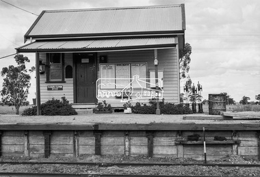
 Port Melbourne Historical & Preservation Society
Photograph - Bay Street shops, Charles Nettleton, Charles Nettleton, 1890s
This photograph was taken by Charles NETTLETON (1826-1902), a prominent Melbourne photographer who recorded the city’s rapid growth from a small town into a metropolis. He was the special photographer for the government and the Melbourne Corporation, and documented of the built environment and major public works throughout Melbourne from when he arrived to Victoria in 1854. Nettleton is credited for having photographed the first Australian steam train, the Melbourne-Sandridge (Port Melbourne) line, which opened in 12 September 1854; the first cricket team to come to Australia on the ss Great Britain in 1861; and Ned KELLY while Nettleton worked as a police photographer.Bay Street shops, 1875:- original Charles NETTLETON print showing west side of Bay Street: Collings & Son, Butcher; Cranston, Paperhanger; Mrs T CLAY; Johnny ALLSORT's Pawn Office; H. DAVENPORT, Clothing; G. RANSOM, Hardware; A.E. AITKEN, Auctioneer; Mrs A. BROWN, Haberdashery; F.C. FORSTER; Marshal, Printer; John PARRY (or BARRY), General Store; E & M RICE. The house is on the site of the 1912 Post Officebuilt environment - commercial, charles nettleton, theresa clay, collings & son, cranston, h davenport, g ransom, alexander ebling aitken, mrs a brown, john parry, john barry, e & m rice, f c forster, johnny allsorts pawnbroker -
 Falls Creek Historical Society
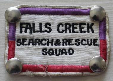
Uniform - Falls Creek Search and Rescue
The Falls Creek Search and Rescue Squad was formed in the mid 1970s. It was partly instigated by Rob Spargo whose family purchased the site where the Falls Creek Hotel is today. The family was instrumental in the establishment and growth of the Falls Creek community and were involved in the foundation of Falls Creek Primary School and Falls Creek Search & Rescue (now Falls Creek SES). Rob was also involved in the start-up of Ski Victoria and has served as a member the Chamber and Resort Management Board. The Falls Creek SES Unit was established in 1981 and includes several members who have served their community with VICSES for more than 30 years.This uniform patch represents an important safety organisation at Falls Creek.A cloth badge with metal studs at each corner. It has a border of purple and crimson machine embroidered stitching and the name of the unit is embroidered in black thread.FALLS CREEK SEARCH & RESCUE SQUADfalls creek ski patrol, skiing safety, falls creek services -
City of Kingston
Photograph - Colour, 29 January 1993
Bonbeach is a small beachside suburb located between Chelsea and Carrum. The station was opened in 1926 and was the last to be established in the group from Aspendale to Carrum. Urban growth began after World War II. State primary and high schools were opened in 1958 on land in Breeze Street that was once occupied by The Australian Glass Manufacturers. Immediately east of the school sites is the Patterson River Golf Club. The Bonbeach sports reserve has five ovals and is home to the Bonbeach football and baseball clubs. The suburb borders the Edithvale-Seaford Wetlands which is the remnant site of the Carrum Carrum swamp, once the home of the Bunurong people.Bonbeach was originally a seaside destination for holidaymakers and the housing comprised of holiday homes and gradually more permanent residents. It was not until 1926 that Bonbeach had its own railway station. From 1906 until the late 1940s sand was quarried on the east side of the railway line and used in the manufacture of glass. The Australian Glass Manufacturers sold this land in residential blocks and Bonbeach's permanent population spread from the coastal strip across to the other side of the railway line. Laminated colour aerial photograph of the suburb of Bonbeach and also the southern section of neighbouring Chelsea within the City of Kingston. The extent of this 1993 aerial image includes: Top left - Maury Road at the south end of the Chelsea shopping Centre; Top right - Scotch Parade Chelsea Bottom left - Monica Avenue in Bonbeach; Bottom right - Patterson River Golf Club. Landmarks include St Joseph's Church and Primary School, Chelsea Primary School, Bonbeach Station, Bonbeach Fotball Club sports playing fields and Bonbeach Life Saving Club. The Edithvale Wetlands is featured prominently to the right-hand side of the image. Black typed writing on white adhesive label: No. 6662 Black typed writing on white adhesive label: 26E/6662, 29/1/93, 4.25 pm Black typed writing on white adhesive label: 29-1-93 Black typed writing on white adhesive label: P000109 Circular yellow adhesive sticker bonbeach, chelsea -
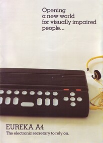 Vision Australia
Equipment - Object, Robotron Pty Ltd, Eureka A4 electronic secretary, 1990s
The Eureka A4 was invented in Melbourne by Milan Hudacek, and designed to capitalise on the growth of IBM PCs. It attached to the PC and allowed blind and vision impaired people to utilise screen orientated programs. It had a sockets for telephone lines, a Braille keyboard, an inbuilt disk drive, speed and volume controls as as well outlets for data ports and headphones. The Royal Victorian Institute for the Blind (now a part of Vision Australia) received both the Eureka Award and the Qantas Rolls Royce Award in 1990 for its participation in the development and promotion of the Eureka A4 computer. It was the first computer of its kind, designed specifically for people who are blind or vision impaired.1 black rectangular box with grey and orange keys with advertising leafletSerial no: 1897braille equipment, assistive devices, milan hudacek -
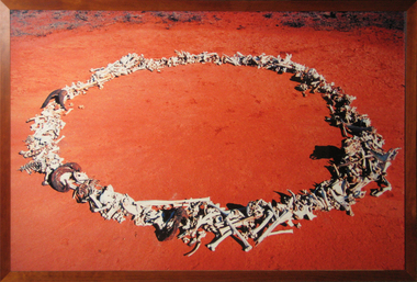 Federation University Art Collection
Artwork, other - Print - large format, Michael Shiell, 'Bone Circle - Documentation' by Michael Shiell, 2001
Nanya Station is a magnificent 40,000 hectare property in far western New South Wales. Its unique system of natural salt lakes, old growth Mallee, and variety of intact ecosystems, makes Nanya a significant refuge for biological diversity. Federation University Australia has been the proud custodian of Nanya since 2004, and values Nanya as an important resource in our research, conservation and education programs. Staff and students are committed to creating a research community to preserve and enrich the biodiversity of this important legacy of the University and the nation. This item is part of the Federation University Art Collection. The Art Collection features over 1000 works and was listed as a 'Ballarat Treasure' in 2007.A photographic documentation of sheep, feral goat and kangaroo bones found and photographed at 'Nanya Station'. art, artwork, michael shiell, shiell, nanya, bones, available -
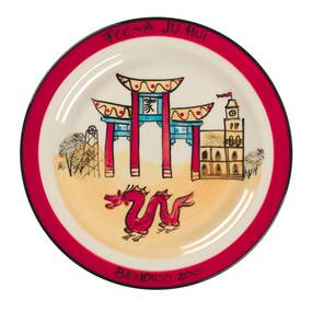 City of Greater Bendigo - Civic Collection
Ceramic - Painted souvenir plates, Bendigo Pottery, 2010
Established by George Guthrie in 1857 (about 5km north of its current site) and then again seven years later in 1864 after it initially closed, Bendigo Pottery remains one of the most influential and longest running Pottery’s in Australia. Over the years the Pottery has contributed to the growth and development of the district through both its products including building products, table ware and decorative and commemorative war as well as artistically, being responsible for training and supporting many potters locally. The City of Greater Bendigo has had a long history of partnering with Bendigo Pottery to produce tourism tableware and the Civic Collection holds a number of important items within its collection.Two plates produced by Bendigo Pottery with hand painted designs depicting iconic Bendigo landmarks. 0408.1 Front: FCC-A JU HUI (To get together) / Bendigo 2010. Verso: Stamped Bendigo Pottery Est 1858 / Australia, signed FB (Faye Brady). 0408.2 Front: Bendigo / Australia. Verso: Stamped Bendigo pottery Est 1858city of greater bendigo tourism, bendigo pottery, faye brady artist -
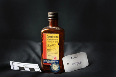 City of Moorabbin Historical Society (Operating the Box Cottage Museum)
Manufactured Glass, brown bottle 'Campholine', c1950
Sigma was founded by two Melbourne pharmacists in 1912, it has grown to become one of the key players in Australia’s pharmacy industry .Edwin Thomas Church (1864 – 1947) and Ernest Holloway Leete a prominent chemist and a member of the College of Pharmacy who had established his own pharmacy in 1897. The entrepreneurial Leete had been part of a move in 1904 among a group of commercially-minded chemists to put up proprietary preparations. 1913 - 1927 Initially, the fortunes of the Sigma enterprise relied on E. H. Leete ‘working from home’, and even as late as 1915 company address was in Claremont Avenue Malvern. Following the establishment of the business in 1912, the Sigma Company Limited was located at Flinders Lane, Melbourne. Sigma – Tromax, 1928 E.H. Leete after sixteen years, said he would not stand again as a director of the company because interests were also turning elsewhere. He was assisting another company as its agent in the motor trade. 1938 to1953 was characterised by steady growth for Sigma, accelerated by manufacturing opportunities during World War Two. Between 1975 and 1996 the company was transformed as it entered a period of both consolidation and rapid growth. The appointment, in 1996, of new Managing Director, George Savvides, marked a break from the past. Today Sigma is a leading full line wholesale and distribution business to pharmacy. Sigma is also the owner of some of Australia’s best known pharmacy brands in Amcal, Guardian and Amcal MaxA triangular shaped, brown glass, bottle with a metal screw top containing ‘Campholine’Front label : Campholine / Camphorated / Mineral Oil / CAUTION ! / Use strictly in accordance / with the directions / Adults : Rub briskly on parts affected . Infants ; Use gentle massage . / 20z. / TROMAX / SIGMA CO. Ltd. / MELBOURNE / Label Sticker : ROBERTSON OF ELSTERNWICK 1/ 8 pharmacy, medicines, campholine, glassware, bottles, moorabbin, bentleigh, cheltenham, melbourne, tromax-sigma co ltd, leete ernest, church edwin, sigma company pty ltd -
 Victorian Interpretive Projects Inc.
Photograph - Digital, Clare Kathleen Gervasoni, St Mary's Kinglake, 2012, 15/12/2012
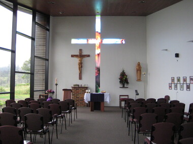
The images depict the newly completed fourth Catholic Church at Kinglake. The previous three churches having been destroyed by 'Black Saturday' bushfire. The painting is oil on canvas. The historical continuity is expressed by the continuity of the skyline and the disconnectedness of the colours. it is not a literal depiction of each church, but a recognizable and symbolic image conveying resilience of faith of the local community. The first church was burnt down in a bushfire, the second burnt down by vandals, and the three burnt down in the 2009 bushfires known as 'Black Saturday'.The white cross and black fence at the lower left commemorated the remarkable fact that these remained intact after the 2009 bushfires. The red-orange can be the colour of the kinglake soil or the fires. The return of new life is indicated by the green growth on the burnt gumtrees. The presence of the Holy Trinity is shown above the entrance to the church. The return of new life is indicated by the green growth on the burnt gumtrees. The presence of the Holy Trinity is shown above the entrance to the church. The Holy Sprit is symbolized by the sulphur crested cockatoo, an Australian bird instead of the white dove. The symbol for the father is above the church in the triangle which has God's Holy Name (I AM) as given to Moses from the Burning Bush, written in Hebrew. Christ is represented by the cross above the entrance. The previous church was destroyed in the 2009 bushfires. The area is surrounded by 22,000 hectares of Kinglake National Park, the largest National Park close to Melbourne. The park was established in 1928 to protect native flora and fauna. Kinglake takes its name from Alexander Kinglake who travelled through the area in 1870. Photographs showing the newly built St Mary's Catholic Church at Kinglake. .1) Interior of Church .2) Painting of the Four Churches of Kinglake by Judy Racz .3-5) Views from the Church windows to the adjoining landscape .6) St Mary's Church groundskinglake, bushfire, black saturday, church, catholic, racz, st mary's catholic church kinglake -
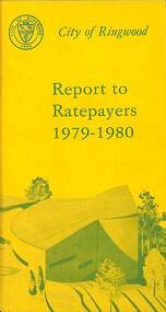 Ringwood and District Historical Society
Booklet, City of Ringwood Report to Ratepayers 1979-1980, 1979
Yellow covered community information booklet for Ringwood residents covering Council and Parliamentary contact details, Council Meeting Dates, Justices of the Peace, Council Finances, Immunizations, Major Works, Planning (Live Theatre/Functions Centre, including Floor Plan), Health and Community Services, Christmas Holiday Play Centres, Lord Mayor's Children's Camp, Rates, Municipal Elections, Dogs, Rubbish Tip, Overhanging Foliage, Vandalism, Building By-laws, Ringwood Library (28 Warrandyte Road), Golf Course, Fred Dwerryhouse Swimming Centre, Netball Complex, Growth of Ringwood Commercial Centre, McAlpin's Reserve Development Plan, Netball Complex, Citizenship Ceremonies, Mini Bikes, School Crossing Supervision, Family Fun Day, Highland Carnival. Includes three City of Ringwood Free Tipping Vouchers valid until the end of 1980 and list of tip charges from October, 1979.Mayor's Message - Cr. P. Gotlib. Inside front cover - Green tinted photograph of Ringwood Memorial Tower captioned: Ringwood - "A Happening Community". Back cover - Green and yellow diagram of Ringwood Civic Centre Development, Stage 2. Floor Plan and description of Theatre and Functions Centre expected to be completed by early 1980.rinx