Showing 520 items
matching link road
-
 Mt Dandenong & District Historical Society Inc.
Photograph, Harmony Vale, c1913
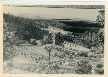
View of Harmony Vale, the original Kalorama settlement taken from Barbers Road. Child's sawmill can be seen (centre) with the log yard to the right. Richardson's home "Harmony Vale' is in the orchard above the logs.Black and white photograph copied from a Rose Series postcard showing the area known as "Harmony Vale' - the original Kalorama settlement. Child's sawmill is in the centre.Rose Series Photo of Harmony Vale on the Olinda Creek taken from Logans Lot 28. Link Rd crossing centre Shiloah complex left centre. Richardsons (Jeannie’s) “Mt Calvin” between trees above tree fern. Isaac Jeeves house with the tree fern floor among trees against forest right centre. Mill yard with logs above cultivated flat. Mill to left. “Harmony Vale” homestead among orchard above logs. “Glenrivers” in gully at top of clearing. About 1913. Copied JLC 1973harmony vale, harmony vale, child's sawmill, sawmill, barbers road, richardson, shiloah -
 Mt Dandenong & District Historical Society Inc.
Photograph, "Bella Vista" Olinda, c1940
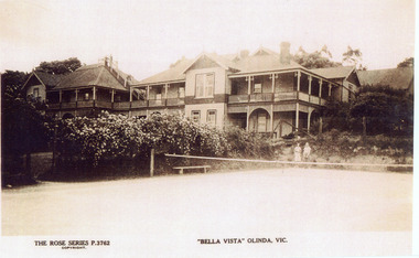
Copy of Rose Series Postcard number 3762Copy of Rose Series Postcard #3762 showing Bella Vista Guest House at Olinda. This image is c1940s and shows the tennis court in the foreground. Bella Vista was built by Edmund Boulter in 1903. It comprised two large buildings with a walkway linking the balconies at second storey level. Views of Westernport and Port Phillip Bays could be seen from the rooftop lookout. Bella Vista was reputed to accommodate eighty guests. The Guest House operated until 1956, when it burned down.bella vista, guest house, tennis, boulter, rose series -
 8th/13th Victorian Mounted Rifles Regimental Collection
Photograph - Staghound
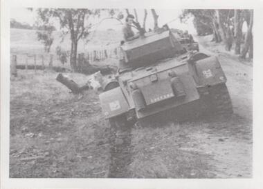
The 8th/13th Victorian Mounted Rifles was raised as a regiment of the Royal Australian Armoured Corps on 1 May 1948 with Headquarters in Melbourne and squadrons in Sale, Benalla/Wangaratta and Albury. In 1955 Regimental Headquarters moved to Wangaratta and a second squadron was located at Albury. The Sale squadron transferred to 4th/19th Prince of Wales’s Light Horse. In 1977 8/13 VMR Regiment was reduced to an independent squadron A Squadron 8th/13th Victorian Mounted Rifles and in 1991 was linked with 4th/19th Prince of Wales’s Light Horse forming the VMR Squadron of that regiment.Unique collection of photographs showing the first years of an armoured regiment of the post-Second World War era Citizen Military Forces showing equipment, uniforms, training and social activity and some personalities.Black and white photograph of Staghound Armoured Car bogged on side of road. Vehicle markings indicate negative has been printer in reverse. One of a collection of photographs of 8th/13th Victorian Mounted Rifles Regiment between 1948 and 1951." Staghound bogged "cmf, vmr, staghound, training -
 8th/13th Victorian Mounted Rifles Regimental Collection
Photograph - Grant tanks
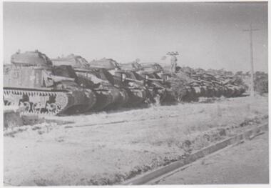
The 8th/13th Victorian Mounted Rifles was raised as a regiment of the Royal Australian Armoured Corps on 1 May 1948 with Headquarters in Melbourne and squadrons in Sale, Benalla/Wangaratta and Albury. In 1955 Regimental Headquarters moved to Wangaratta and a second squadron was located at Albury. The Sale squadron transferred to 4th/19th Prince of Wales’s Light Horse. In 1977 8/13 VMR Regiment was reduced to an independent squadron A Squadron 8th/13th Victorian Mounted Rifles and in 1991 was linked with 4th/19th Prince of Wales’s Light Horse forming the VMR Squadron of that regiment.Unique collection of photographs showing the first years of an armoured regiment of the post-Second World War era Citizen Military Forces showing equipment, uniforms, training and social activity and some personalities.Black and white photograph of line of ten General Grant tanks parked close together along side of road. One of a collection of photographs of 8th/13th Victorian Mounted Rifles Regiment between 1948 and 1951.' Grant training at Puckapunyal )armour, tank, grant, puckapunyal -
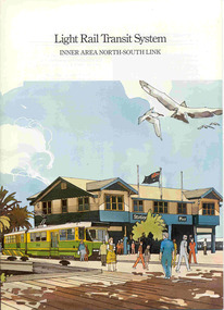 Ballarat Tramway Museum
Book, Metropolitan Transit Authority (MTA), "Light Rail Transit System - Inner Area North-South Link", c1986
Sixteen page book, A4 portrait format, saddle stapled, titled "Light Rail Transit System - Inner Area North-South Link", published by the Metropolitan Transit Authority detailing the conversion of the former heavy electric suburban railway lines to St Kilda and Port Melbourne to electric trams or Light Rail. Has foreword by Tom Roper, Minister for Transport, Describes the proposed system, vehicles, development of articulated vehicles (2001, 2002), interchange with rail services, travel times and a map showing the proposed route, including a possible extension along Mitford St. and Broadway to Glenhuntly Road. Has a number of artists impressions of the vehicles at Station Pier and South Melbourne station. Includes colour photographs of the vehicles, conductors and photos of other light rail systems in Hanover and Amsterdam. Published c1986.trams, tramways, melbourne, light railways, mta, st kilda, port melbourne, articulated trams -
 Otway Districts Historical Society
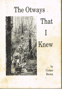
Book, Merimbula Easiprint, The Otways that I knew, 1993
Condensing 100 years of Otway history the author tries to give an insight into the thoughts and ways of the settlers in opening the western Otway Ranges. It gives some indication of the mental pressure, hand-in-hand with the physical stress, as a settler cleared the land and made a living for his family. It covers how the rail link brought in the timber mills and their workers which made timber the main industry of that era, and covers the changes that took place in the 1930s as the mills closed down and the district raised crops, dairying and grazing.The Otways that I knew. Ronald Charles 'Corker' Brown. 1st ed. Corker Brown; np; 1993. 216 p.; illus; maps. Soft cover. ISBN 0 646 16798 7otway ranges; corker brown; otway lighthouse; aborigines; beech forest; farming; grazing; crops; railways; roads; timber; -
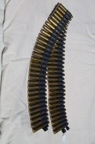 Running Rabbits Military Museum operated by the Upwey Belgrave RSL Sub Branch
Machine Gun Belt
Belt with used shells, linked ). 30/06 Calammunition, korea, army -
 Running Rabbits Military Museum operated by the Upwey Belgrave RSL Sub Branch
Belt
Linked Ammunition for Machine Gunammunition, korea, army -
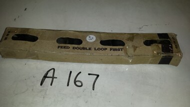 Running Rabbits Military Museum operated by the Upwey Belgrave RSL Sub Branch
10 Link Belt
50 Cal 10 link belt M2 in original package.ammunition, vietnam, army -
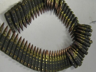
 Running Rabbits Military Museum operated by the Upwey Belgrave RSL Sub Branch
Bullets
14 x 7.62cal blanks, (5 linked)ammunition, ww2, army -
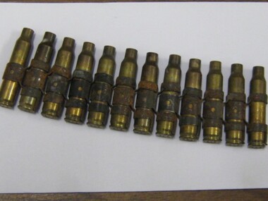 Running Rabbits Military Museum operated by the Upwey Belgrave RSL Sub Branch
Shell Case
12 x 5.56cal linked machine gun cases.ammunition, ww2, army -
 Bendigo Historical Society Inc.
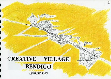
Book - MERLE HALL COLLECTION: ROSALIND PARK CREATIVE VILLAGE BENDIGO PROJECT BOOK, 1995
Merle Hall Collection: Rosalind Park Creative Village Bendigo Project Book. August 1995 Book contains a description, aims of the programme and a linking plan. 35 Pages: Cover Intoduction, The Design Team, Acknowledgement Project Brief Map of Linked Park The Linking Plan described Linking plan graphic Golden Beacon Design Concept Bridge Beacon Entrance to Linear Park Gasworks Café Pavillion Gasworks layout plan Golden Beacons Concept Botanical Gardens Café Botanical Gardens layout plan Victoria Hill Interpretation Centre Victoria Hill layout Victoria Hill plan Victoria Hill continued Victoria Hill continued Rosalind Park Lookout Method 3D Road Map 3D Road Map Continued Implementation Community Participation Oppurtunities, Mosaic Works Appropriate sites Appropriate sites continued Consultaion Summary and Issues Ideas Areas for further consideration Graphic The Design Team - Grant Fink, Jane Marriott, Laszo Biro, James Brearley Graphic Layoutbook -
 Kew Historical Society Inc
Legal record - The Indenture, Crown Portion 86, otherwise known as 'The Morgan Deed', 1852 (and later)
This indenture once formed part of the City of Kew's Municipal Collection. Cr. W.D. Vaughan in his history 'Kew's Civic Century' (1960) records on page 194 that: "The original deed of conveyance of the land being all of Crown Portion 86, Kew, purchased by John Quick, James Venn Morgan, Samuel Derrick and William Derrick was presented by the Historical Society of Victoria on behalf of Mrs Fryer, a daughter of the later J.V. Morgan, to the [Kew] Council on August 5, 1941. Crown Portion 86, comprised all the land between Cotham Road and High Street to an alignment opposite the east boundary of Glenferrie Road. On it the first residential house was built by Mr. J.V. Morgan in 1852." Following the donation, the Indenture was surrounded by other original related text and explanatory notes and framed. The resulting framed documents are the largest framed objects in the collection.The Indenture and the accompanying contextual documents are some of the most historically significant manuscripts to have survived since the settlement of Kew in the 1850s. They provide a link to Kew's most famous pioneering families.Framed 1952 Indenture recording the sale of land in Kew to pioneering Kew families.james venn morgan, john quick, william derrick, samuel derrick, kew (vic) - history, kew (vic) - pioneers, samuel watts, kew (vic.) — municipal collection -
 Kew Historical Society Inc
Archive (Sub-series) - Subject File, Kew Historical Society, North East Link, 2019
Various partiesReference, Research, InformationSecondary Values (KHS Imposed Order)Subject file containing documents relating to the development and impact of of North East link in Melbourne.north-east link, transport infrastucure - kew (vic), roads - kew (vic), streets - kew (vic), freeways - kew (vic)north-east link, transport infrastucure - kew (vic), roads - kew (vic), streets - kew (vic), freeways - kew (vic) -
 Kew Historical Society Inc
Photograph - Filling in the Outer Circle Railway cutting at East Kew, 1939
W.D. Vaughan (Kew's Civic Century, 1960, pp.195-6) quotes Council Minutes of 1938 and 1939 to record that: "After protracted negotiations between the Council, the Railways Department and the Tramways Board agreement was reached in June, 1938, for the filling of the railway cutting at the Harp Junction and shifting tram tracks to the High Street alignment ... The Outer Circle railway land from Princess Street to Park Crescent was purchased by the Kew Council in October, 1939, for 2,750 [pounds]. The land from Park Crescent to High Street was leased for 1 [pound] per annum. Considerable work was done in levelling the embankments to the original surface level."Important and rare photograph of the period, showing major works by Kew Council in Kew East working on a significant piece of urban infrastructure.Small, original black and white positive (photograph) showing workers and vehicles filling in the tracks of the former Outer Circle railway at East Kew. In the background is the metal bridge with brick piers, adjacent to the Harp Junction. The bridge crossed the cutting, linking the two parts of High Street. Behind the tip truck, painted on the side with the name 'Fowler Quarries' [located Keilor Road, North Essendon], one can see shops [including T.G. Garroway, Cash Grocer] in High Street. What appears to be the City of Kew Steamroller is immediately in front of the bridge. A group of passers-by watch from the bridge and from the road. Annotation in pencil on verso: "Filling in Outer Circle line at High St East Kew prior to straightening High St. (c. Feb 1930?)outer circle railway, railway cuttings, harp junction, high street -- kew east -
 Kew Historical Society Inc
Plan - Subdivision Plan, Boulevard Estate - Boulevard Section, 1930-1936
Pru Sanderson, in her groundbreaking ‘City of Kew Urban Conservation Study : Volume 2 - Development History’ (1988), summarised the periods of urban development and subdivisions of land in Kew. The periods that she identified included 1845-1880, 1880-1893, 1893-1921, 1921-1933, 1933-1943, and Post-War Development. These periods were selected as they represented periods of rapid growth or decline in urban development. An obvious starting point for Sanderson’s groupings involved population growth and the associated economic cycles. These cycles also highlighted urban expansion onto land that was predominantly rural, although in other cases it represented the decline and breakup of large estates. A number of the plans in the Kew Historical Society’s collection can also be found in other collections, such as those of the State Library of Victoria and the Boroondara Library Service. A number are however unique to the collection.The Kew Historical Society collection includes almost 100 subdivision plans pertaining to suburbs of the City of Melbourne. Most of these are of Kew, Kew East or Studley Park, although a smaller number are plans of Camberwell, Deepdene, Balwyn and Hawthorn. It is believed that the majority of the plans were gifted to the Society by persons connected with the real estate firm - J. R. Mathers and McMillan, 136 Cotham Road, Kew. The Plans in the collection are rarely in pristine form, being working plans on which the agent would write notes and record lots sold and the prices of these. The subdivision plans are historically significant examples of the growth of urban Melbourne from the beginning of the 20th Century up until the 1980s. A number of the plans are double-sided and often include a photograph on the reverse. This plan shows a subdivision with two sections: the ‘Boulevard Section’ and the ‘Riverside Section’. The first of these sections bordered Burke Road between Kilby Road and the farm beside the Yarra. Kilby Road, Munro Road, Burke Road and Old Burke Road bordered the 102 lots in the Boulevard Section of the plan. The streets within the Section included Walbundry Avenue, Inverness Way, Riverside Avenue, Cascade Street and Kyora Parade. These street names, at least in this subdivision plan linked the two Sections of the subdivision. At a later date, the City of Kew decided to alter the street names. Walbundry, Inverness, Riverside, Cascade and Kyora were all renamed as ‘Drives’ (e.g. Kyora Drive). The subdivision plan is of interest in that it names High Street in Kew as Doncaster Road. It also shows the location of the wooden church that was later removed to Yarraville on the corner of Kilby Road and High Street. The plan predates later developments such as the S. E. Dickens Supermarket.subdivision plans - east kew, boulevard estate, munro road -- kew east (vic.), kilby road -- kew east (vic.), burke road -- kew east (vic.), walbundry avenue -- kew east (vic.), inverness way -- kew east (vic.), riverside avenue -- kew east (vic.), cascade drive -- kew east (vic.), nyora parade -- kew east (vic.) -
 Kew Historical Society Inc
Postcard, Victoria Street Bridge, Collingwood, 1905-1913
Victoria Bridge is a riveted and welded steel Warren truss bridge over the Yarra River completed in 1884 to a design by Fraser & Chase following a controversial design competition held in 1880. Funds for the bridge's construction were provided by the councils of Collingwood, Hawthorn, Kew and Richmond. The contract was awarded to Mr P. Platt. Charles Rowand was officially appointed Supervising Engineer in 1883. The winning design was based on the theoretical work of William Charles Kernot (1845-1909) who campaigned for economy in public works design and the application of scientific principles in engineering. ... The bridge was widened in 1890 by the addition of a third line of truss on new piers on the up stream side to carry horse trams. Work commenced in 1914 to convert the horse tramway to an electric tramway by the Prahran & Malvern Tramways Trust, part of the Trust's extension of its tramway into the eastern suburbs between 1913-18. In 1915 the bridge was further strengthened to accommodate the extra weight of electric trams and widened by the addition of two six feet cantilever footpaths. During this period the Prahran & Malvern Tramways Trust erected two ornamental gantries over the roadway to support overhead wires for the electric tramway. Further widening and reconditioning of the bridge took place in 1933, including the addition of four new welded trusses, two intermediate and two on the outside. The latter were supported on new cantilevered truss cross beams attached to the top of the piers. (Source: Heritage Victoria)Early and rare postcard of the Victoria Street Bridge linking Victoria Street and Barkers Road.Polychrome postcard of the Victoria Street Bridge which links Richmond and Abbotsford with Kew and Hawthorn.View from Harrison Cres embankment / former Xavier College boatshed on site of tree in foreground. / Chimney left corner - Wool Scoring Mils in Victoria St. / On horizon - Studley Villa, Studley House circa 1880s, Studley Hall / Chinese gardens to be seen behind three set of columns / M.J. Slatterypostcards -- yarra river, postcards -- bridges. -- greater melbourne (vic.), victoria street bridge -
 Kew Historical Society Inc
Plan - Subdivision Plan, J Hurrey, Section 115 in the Parish of Boroondara Near Richmond Bridge, 1853
Despite the plans claims that it is a subdivision near the Richmond Bridge, Section 115 was located at what is now Camberwell Junction. While the plan only lists government roads rather than named streets, the section was located on the east side of Burke Road, stretching up the hill from the current Junction. Research on Trove, conducted by Kerry Fairbank, discovered an advertisement for unsold lots in Section 115 which clarifies the extent and location of subsequent land sales in the original section. The original article can be viewed through the link in the catalogue record. The interesting link to Kew is the reference to James Beavan as the purchaser of lots 14 and 15. The historian Gwen McWilliam has notes that a Mr Beavan changed his name from Bevan. The Bevans were descendants of the Derricks family of Kew. This subdivision plan is the earliest original map or plan in the collection which shows parts of what is now the City of Boroondara, dating from circa 1853. It provides important information for researchers on subsequent subdivisions following the original land sales in [Camberwell] Boroondara. The site, on the east side of Burke Road is a highly-significant and historic site. This is believed to be the only extant copy of the subdivision in public collections.A small plan on parchment listing 28 lots, between one and two acres each, for sale in Section 115 in the Parish of Boroondara, dating from 1853 when the portion was subdivided.Obverse: Lot 16 "Joseph Duval", Lots 14 & 15 "James Beavan". Other annotations (measurements) are unreadable. Reverse: "KH-981 / Section 115 in the Parish of Boroondara / Near Richmond Bridge / 1640T. / J Duval / 14-15 J. Beavanparish of boroondara, subdivision plans - camberwell, section 115 - boroondara, subdivision plans -- camberwell (vic), riverscape road, burke road, camberwell junction -
 Kew Historical Society Inc
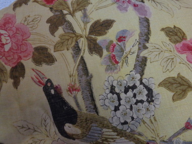
Decorative object - Paradise Bird Design Linen Curtains, GP&J Baker, 1920s
William Turner, a Scottish born free-lance designer, who was contracted to GP&J Baker, painted the image on which the design was based in 1918. Turner had trained as a furniture designer before leaving for London in the 1890s, where he rose to prominence as an Arts & Crafts designer. The bird that gives this design its name is adapted from Robert Havell’s ‘A Collection of Birds of Paradise’, published in 1835, and was a favourite of Victorian chintz designers.“Paradise Bird” has been in continuous production since its creation. The hand-block print, of which these curtains are an early example, was supplemented by a version engraved on copper rollers in 1962, and was updated onto screens in 1982. The curtains have significance to the collection because of their intrinsic value and for the link to one of the historic mansions in the City of Boroondara. The curtains by G.P & J Baker of London use one of the exemplary designs in this manufacturer’s output. The first use of the design was in 1918, following the Great War, and the design is said to reflect the hope for peace which was a feature of the postwar years. The curtains are an early example of the Paradise Bird design, and were block printed. A pair of curtains originally situated in one of the front reception rooms of 'Tourmont' in Balwyn Road, Balwyn (now Fintona Girls’ School). The fabric in the curtains was manufactured by the English firm of GP&J Baker. The textile design is variably named as ‘Paradise Bird’ or more recently, ‘Hydrangea Bird’. Turner’s bird perches in a blossoming branch directly above a woodpecker, which is an attribute of Mars, god of war. Thus the design reads as a symbolic statement where War is reversed and Paradise returns (a hopeful message at the end of WWI). “Paradise Bird” has been in continuous production since its creation. . curtains, fabric design, historic buildings -
 Kew Historical Society Inc
Album - Photographs of heritage sites in Victoria, Eva Grant, 1964-66
Eva Grant was a member of the Kew Historical Society. Three albums in the collection were created by her, this one, the third created between 1964 and 1966. They were donated to the Society by her daughter in 2010. Each of the albums includes photographs and newspaper cuttings collected on her travels to historic places in South East Australia in the 1950s and 1960s. Particular structures photographed in this album include: Barnawatha (Vic.) - The Hermitage | Beveridge (Vic.) - Stone cottage where Ned Kelly was born. | Brighton - St Andrew’s Church graveyard. | Chiltern (Vic.) - lake view [missing] | Cowes (Vic.) - ‘Broadwater’ [originally home of Henty-Wilson family], demolished 1965; Bell of the Speke wreck; Edward’s tree. | Euroa (Vic.) - Habbies Howe | Fairfield (Vic.) - Dight’s Falls; John Dight. | Fernshawe (Vic.) - Queen Mary tree. | Jolimont (Vic.) - Old railway tunnel linking the first Government House (1964); Sign identifying location of first Government House. | Kew (Vic.) - Cairn at Dight’s Falls; Canoe tree, Bowyer Avenue. | Kyneton - De Grave’s Flour Mill - “C”. | Maldon (Vic.) - Chinese oven; Macarthur’s House; Maldon’s oldest resident; Chinese graves x 2; [Beehive Chimney]. | Marysville (Vic.) - Centenary cairn | Mitcham (Vic.), Mud brick house x 2, Deep Creek Road. | Melbourne (Vic.) - St Paul’s Cathedral [renovation] (1964); Wreckers at Damman’s Corner, cnr Bourke and Collins Streets (1964); Princess Gate project x 2 (1964); Colonial Storekeeper’s building on cnr King and Bourke Streets (1966); Early observatory 1861-3; the Honey Memorial. | Mt Oberon (Vic.) - [obsolete] radio telephone dish. | Seymour (Vic.) - Habres (sic) House x 3.| Swan Hill (Vic.) - Major Mitchell’s Cairn (12/1964); Headstone of Andrew Beverage AM (12/1964). | Templestowe (Vic.) - Finn’s Hotel. | Thornton (Vic.) - Eildon Station. | Werribee (Vic.) - Chirnside Memorial [Presbyterian] Church; gaslight beside church | Location unknown, but possibly Swan Hill - Brick house; Wooden bullock dray. | Location unknown - Headstone of John Furlonge 1835.Important record of significant heritage properties in Victoria, many of which have since been demolished.30 page spirex bound drawing book including photographs and newspaper articles of historic buildings in Victoria. The front cover has a picture of a steam boat. The cover is encased in plastic. A number items in the album are annotated with written commentary by Eva Grant who compiled the album. Annotations and transcriptions by Eva Grant on most imageseva grant, photograph albums, heritage places - victoria -
 Friends of Westgarthtown
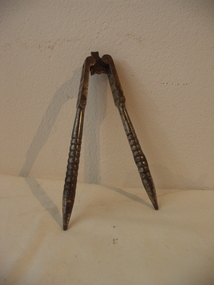
Nutcracker
Hinged, electro-plated steel nutcracker with two identical arms on short link. Flat, squared sections near hinge with rows of four indentations on each side. Arms rounded with turned grip rings, pointed at end.No visible markingsdomestic items, food preparation, nutcracker, steel, hinged -
 Friends of Westgarthtown
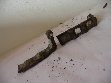
Agricultural drive chain
Two parts of an agricultural drive chain with rectangular links. Both pieces are believed to be from the same chain and have rusted in to an L-shape.No visible markingsrural industry, farm machinery, drive chain, machinery, link, steel, forged, agriculture. -
 Clayton RSL Sub Branch
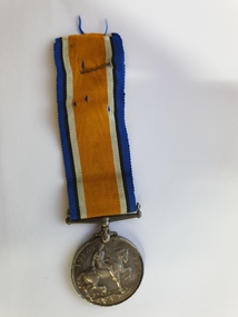
Medals - British War Medal, Medal
YOUNG, John Alexander 3739 Rank: Gunner 13th Field Artillery Brigade Date of enlistment: 20.04.1917 Returned to Australia: 17.03.1920 (possibly dies of wounds), listed as fate date for return to AustraliaBritish War Medal 2 medals not linked, ribbons held together with safety pinYOUNG, John Alexander 3739 Gunner 13th F.A.B A.I.F -
Glen Eira City Council History and Heritage Collection
Book, 2015 ANZAC Centenary Poppies Community Project Book, 2015
The 2015 ANZAC Centenary Poppies community project was run by Glen Eira City Council, community artists and the Glen Eira community. Glen Eira Council encouraged community involvement by inviting the community to handmake poppies (knitted, crocheted, felted or crafted, no more than 15cm in diameter) to be included in a display in the Town Hall’s gallery from April the 8th. The Poppies Community Project Display will be held from 8th April - 17th May 2015 in the Gallery Annexe at Glen Eira Town Hall, with the hundreds of poppies arranged and linked by artist Emma Davies. The display was accompanied by a display of war memorabilia and artefacts, and visitors were invited to record their own dedication in a commemorative book.This large, black book is embossed with the square logo for the City of Glen Eira on the front. It contains tributes and dedications made by members of the community as part of the 2015 ANZAC Centenary Poppies community project under the headings "Date / Name / Dedication". The object also includes an unattached handwritten letter, and a handwritten label attached to one dedication. The dedication entries are dated from 10/04/2015 to 17/05/2015. -
 8th/13th Victorian Mounted Rifles Regimental Collection
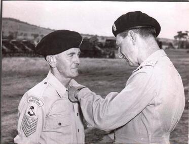
Photograph
The 8th/13th Victorian Mounted Rifles was raised as a regiment of the Royal Australian Armoured Corps on 1 May 1948 with Headquarters in Melbourne and squadrons in Sale, Benalla/Wangaratta and Albury. In 1955 Regimental Headquarters moved to Wangaratta and a second squadron was located at Albury. The Sale squadron transferred to 4th/19th Prince of Wales’s Light Horse. In 1977 8/13 VMR Regiment was reduced to an independent squadron A Squadron 8th/13th Victorian Mounted Rifles and in 1991 was linked with 4th/19th Prince of Wales’s Light Horse forming the VMR Squadron of that regiment.Black and white photograph of Brigadier H.H. Hammer, Commander 2nd Armoured Brigade and Staff - Sargeant R.J. Roberts, Orderly Room Sergeant of 8/13 Victorian Mounted Rifles.Comd 2 Armd Bde, Brig H.H. Hammer, pinning British Empire medal on S/Sgt R. J. Roberts, Earlsfield Road, Hampton, O/Room Sgt of 8/13thVictorian Mounted Rifles at Puckapunyal Camp during 14 day camp of Regiment in January. S/Sgt Roberts saw service in M.E., England, and South Africa with Australia Mil Liaison Staff. S/Sgt Roberts was a member of champion Victorian debating team, and trained Regt team to highest standard yet attained in services.Gave up great deal of own time in this work, and also re-organizing orderly rooms of units in country areas. Is a member of ARA. -
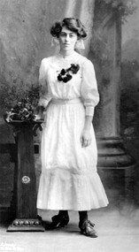 Surrey Hills Historical Society Collection
Photograph, Mabel Pye, daughter of William and Alice Pye of 12 Loch Street, Surrey Hills
Mabel Pye was a printmaker and painter. She was born in Box Hill in 1894, probably at the family’s Loch Street property. She was the daughter of Alice Eleanor Noar and her husband William Edward Pye, who married in 1893. William was known as Ted and is recorded in electoral rolls as a legal clerk and later as a public servant. Mabel had a sister Hazel who was also an artist, but less well known. 12 Loch Street, Surrey Hills was known as ‘Mulberry Hill’ and the Pyes appear to be the first occupants – Alan Holt’s register of Surrey Hills properties has them there from c1900. The property was originally about an acre in size and was later divided into 4 house blocks. In 1923 they built a house for themselves on one of the blocks facing Benwerrin Street and called it ‘Tanglewood’. The Loch Street house abutted the Surrey Hills Reservoir and was diagonally linked to the land in Benwerrin Street. In 2019 both the houses still stand. The family were involved in amateur theatre and at times the studio doubled as a rehearsal space for the Benwerrin Players, a group which operated through the late 1920s and early 1930s being comprised of friends and neighbours from Benwerrin Street and Windsor Crescent. Some of their performances were at the Surrey Hall in Union Road. Most of Mabel’s known work dates from the 1930s. She had studied under Bernard Hall at the National Gallery School. Mabel was a member of both the Victorian Artists Society from 1918-1941 and also the Melbourne Society of Women Painters and Sculptors from 1920-1950. Her work is represented in the Australian National Collection and in state galleries. The NGV has one of her works, the Gallery of NSW has 9 works, a large body of works and personal material is held by the Ian Potter Collection and there is one piece in the City of Whitehorse Collection. This ink sketch of the White Horse Hotel is signed MP and dated 1933, the year the building was demolished. A black and white studio photograph of a young lady standing beside a pedestal and wearing a light coloured dress with 3/4 length sleeves, dark stockings and lace up shoes. A corsage of dark flowers adorns the bodice. loch street, surrey hills, artists, whitehorse hotel, box hill, miss mabel pye, city of whitehorse collection, william edward pye, miss alice elanor noar, mrs alice eleanor pye, frank stamford -
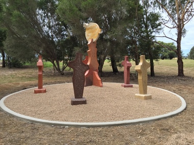 Federation University Art Collection
Sculpture, 'Mungo Moon' by Don Barrett, 2015
'Mungo Moon' by Don Barrett is the first sculpture erected on the Churchill Art and Culture Pathway. It was officially unveiled by Professor David Battersby on 15 April 2015 From Churchill & District News 16 October 2014 The Churchill Art and Culture Walking Pathway will have its official public opening on Saturday October 18, with a walk finishing at Federation University Australia’s Switchback Gallery at the Federation University Gippsland Campus. ... An important link on the newly developed pathway was recently completed with a path south of the FedUni Student West Residences. The path now allows walkers to turn off the Eel Hole Creek path before reaching Glendonald Estate and to follow a picturesque, tree lined walkway to join up with the footpath on the Eastern side of Northways Road. From there the footpath joins into Federation University’s network of walking paths that proceeds past the Switchback Art Gallery, down through the pine plantation and along Lake Kretlow and the Churchill Golf Course. Project Manager Mike Answerth, said the opening of the West Residences section of the path means there is now only one short link to complete. “We’re now very close to realising the project’s objective to join up all these walking paths to provide a continuous pathway that encompasses town, campus and parkland. The next stage of the project will be the completion of Latrobe City’s East West Link and the enhancement of the walking path with artistic and cultural features.” said Mr. Answerth. Head of Federation University Australia Gippsland Campus, Dr Harry Ballis, said the project had been made possible through the contributions of the five former Gippsland Education Precinct (GEP) partners. “The Art and Culture Pathway represents another important step in joining the Churchill township and the university campus as a physical and social entity,” Dr Ballis said. “This was an initiative of the GEP and it is pleasing to see it coming to fruition.” The path now reaches as far as the golf driving range but plans are already under way to connect with the Mathison Park board walk and pathway, which surrounds Lake Hyland in Churchill. When the loop is completed, residents and visitors will have an approximately 5km circular walking path which links up the Churchill town centre, Federation University Australia and Mathison Park. There are already art features along this route, including primary schools’ Bug Blitz totems near the Kurnai College school crossing, native vegetation and history panels near the Hare Homestead in Mathison Park, and outdoor sculptures in the pine trees near the Federation University Switchback Gallery. contemporaryA large sculpture in five pieces set in an external location. It is part of the Churchill Art and Culture Walking Pathway. Don Barrett’s work is mainly in concrete with added coloured oxides to portray the feeling of the Australian landscape. Barrett focuses on concepts of Australia’s short history and indigenous history. churchill art and culture pathway, barrett, don barrett, gippsland campus, federation university, churchill, sculpture -
 Vision Australia
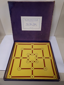
Leisure object - Object, Nine men's Morris, 19
This game of strategy was played in the Roman Empire and medieval England. Each player has nine pegs and must use these to first fill the board then move their pieces to create a 'mill' (three linked points). For each 'mill' created, an opponent's piece can be removed. In this version of the game, a rule booklet in Braille is provided with the tactile board and pegs. RNIB catalogue number: 9212. 1 yellow and red board in purple box +1 Braille booklet. recreation equipment, games -
 Vision Australia
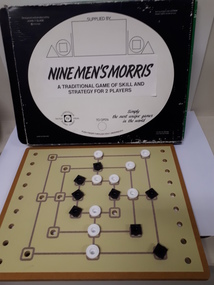
Leisure object - Object, Nine men's Morris, 19
This game of strategy was played in the Roman Empire and medieval England. Each player has nine pegs and must use these to first fill the board then move their pieces to create a 'mill' (three linked points). For each 'mill' created, an opponent's piece can be removed. In this version of the game, a rule booklet in large print is provided with the tactile board and black/white pegs. RNIB catalogue number: GB32. 1 wooden board in green/black box + 1 large print booklet and 17 pegs. recreation equipment, games -
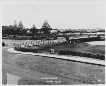 Port Fairy Historical Society Museum and Archives
Postcard, Moyne River Port Fairy
This bridge was built in 1902, replacing a previous structure that crossed the Moyne River from 1857 and linked Belfast with Belfast East, as the two areas of Port Fairy were then known. Prior to that, passage over the river was via a ford (an underwater stone track that allowed wagons to cross when the river was low) located just north of where the current car bridge stands. The present bridge survived the great flood of 1946, but has been the subject of innumerable patch-up jobs over its 114 years. In 2012, the bridge underwent a detailed structural assessment and was given the OK for the next eight to 10 years, notwithstanding the need for regular maintenance works. At the time, it was estimated a new bridge would cost between $2-3 million. It was extensively refurbished in 2016Sole means for traffic to cross to the east side of Port FairyBlack and white photographMoyne River Port Fairyriver, moyne, bridge, road