Showing 1654 items matching "property history"
-
 4th/19th Prince of Wales's Light Horse Regiment Unit History Room
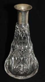
Decanter, Not later than 1937
Crystal decanter, with EPNS (?) top. Stopper missing. 20TH LIGHT HORSE REGIMENT (Victorian Mounted Rifles) Presented by LIEUT. A. CLARK October 1937decanter, mess property, decanter, mess property -
 Kiewa Valley Historical Society
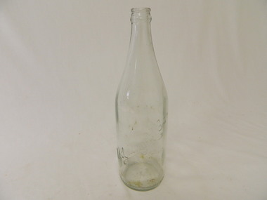
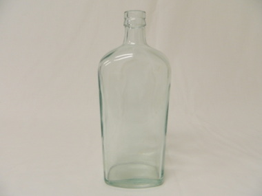
Bottle - Soft Drink, c1940s
Soft drink came in bottles bought at the local grocery store or at a larger city store on a shopping expedition. The shape of the bottles changed as did the stopper used to seal it. Bottles were re cycled remaining the property of the manufacturer. The history of Zedmanfg Company, Albury. Historical: Change of bottles - shape, glass, stopper, embossing, use. Aesthetic: Display showing embossing & shape especially if in good condition. Clear glass bottle. Bottom half has straight sides. Upper half tapers to the top where a metal crimp fits over the lip. Manufacturer's name is heavily embossed in cursive script diagonally across the lower half. The place 'Albury' is embossed below the diagonal script, in capital letters.There is heavy embossing at the base and at the bottom of the sides. All in capital letters. It has a crown seal - AGMZedManfg Co. Albury - across the bottom half of the bottle. At the base on the sides around the circumference 'This bottle is the property of the Zedmanfg Co. Albury. On the Base: F1486, GM inside A, M 113 glass, bottle, domestic, household, albury, zedmanfg co., drinks, lemonade -
 Kiewa Valley Historical Society
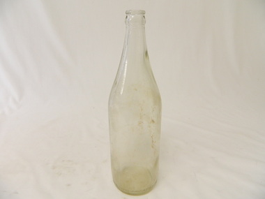
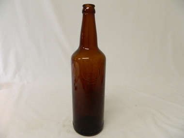
Bottle - Beer, 1950s - 1960s
Beer came in bottles sold at licensed premises either locally or in larger cities visited during shopping expeditions.The shape of the bottles changed. The bottles were re cycled remaining the property of the manufacturer who paid for them. History of the Richmond Brewery, Richmond.Historical: Change of bottles - shape, glass, embossing. Collected by bottle collectors. Aesthetic: Display showing embossing & shape especially if in good condition.Clear glass bottle used for beer. Bottom half has straight sides. The top half tapers to the opening where a metal crimp fits. It has a crown seal. The glass is joined on two sides longitudinally. It is heavily embossed, in capital letters, around the base of the side around its circumference and at the base.Bottom sides: 'The property of Richmond N.S. Brewing Co. Pty. Ltd.' Base: 'R.B.' and underneath these letters 'R.'. and in between and much smaller S.3.bottle, beer, richmond brewery, drink, richmond -
 Kiewa Valley Historical Society
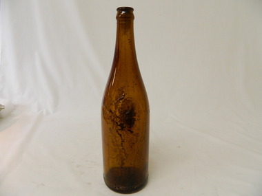
Bottle - Beer, 1930s
Beer came in bottles sold at licensed premises either locally or in larger cities visited during shopping expeditions. The shape of the bottles changed. Bottles were recycled remaining the property of the manufacturer who paid for their return. History of the Richmond Brewery.Historical: Change of bottles - shape, glass, embossing. Collected by bottle collectors. Aesthetic: Display showing embossing & shape especially if in good condition.Clear brown bottle with heavy embossing. The bottom half has straight sides. The top tapers to the opening. Half way up the sides it is heavily embossed with R.B. and underneath these letters R. The face of a tiger features in heavy embossing on the side of the bottle. At the bottom around the circumference and on the base is embossing. There is a broken cork sealing the bottle. Sides: R.B. and underneath this R. with a head of a tiger. Bottom around the circumference: 'The property of Richmond N.S. Brewing Co. Pty. Ltd.' Base: '650'beer, drink, bottle, richmond brewery, richmond -
 Kiewa Valley Historical Society
Bottle - Beer, 1930s - 1940
Beer came in bottles sold at licensed premises either locally or in larger cities visited during shopping expeditions. The shape of bottles were recycled remaining the property of the manufacturer who paid for their return. History of Manufacturers Bottle Co. of VictoriaHistorical: Change of bottles - shape, glass, embossing. Collected by bottle collectors. Aesthetic: Display showing embossing & shape especially if in good condition.Clear brown glass beer bottle. Straight sides 190 mm from base. Sharp taper to neck which tapers for 90 mm to opening. At top of straight side is a heavily embossed spade (as in cards) shape with M.B. at top and C.V. beneath - both inside spade shape. Bottle made with 2 longitudinal halves. At the bottom near the base is heavily embossed print (in capital letters) around the circumference. At the base is embossed a horseshoe shape.Inside spade shape: M. B. above C. V.. Along the circumference at the bottom "The Property of Manufacturers Bottle Co. of Victoria Pty. Ltd.'. At the base; A horse shoe shape with a pointed curve.bottle, beer, munufacturers bottle co. of victoria, horse shoe shape on bottle, spade shape on bottle -
 Kiewa Valley Historical Society
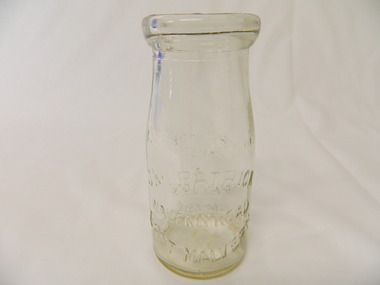
Bottle - Cream, 1935
Cream came in bottles bought at the local store or at a large city store on a shopping expedition. The shape of the bottles changed as did the stopper used to seal it. The amount of liquid was measured in ounces and pints pre 1966. History of J. Kikpatrick, Waverley, East malvern.Historical: Change of bottles - shape, size, stopper, embossing and use. Aesthetic; Display showing embossing and shapeClear small glass cream bottle with heavy embossing on both sides. Inside the opening is a rim to hold a cardboard disc used to seal the bottle. The sides are straight half way up then taper to the opening. One side: The Property of / J. Kilpatrick (half moon on top) / Waverly Road (across middle) / East Malvern (half moon on bottom) Other side: Please / wash / & / Return (also curved with & in the middle) Along side at base: "Contents not less than 8 ozs." Base: Across middle M93 above M, and AGM below. cream, dairy, milkbar, bottle, household -
 Kiewa Valley Historical Society
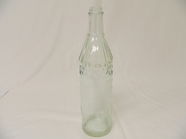
Bottle - Spirits, 1940's
Whisky came in bottles sold at licensed premises either locally or in larger cities visited during shopping expeditions. The shape of bottles varied. Bottles were recycled remaining the property of the manufacturer who paid for their return. History of James Dickson Co. Pty. Ltd.Historical: Change of Bottles - shape, glass, embossing. Collected by bottle collectors. Aesthetic: Display showing embossing and shapeClear glass whisky bottle with heavy embossing on one side where the maker's name and details is printed in capital letters longitudinally. Heavily embossed zig zag pattern at the top of straight sides that go three quarters of the way up. The sides taper to the neck which has straight sides to the screw top opening. The tapered section is grooved with ridges of straight lines to a lip which is between it and the neck. Side (longitudinally): 'This Bottle is the Property of / James Dickson & Co. Pty Ltd / Established 1854 / Melbourne Aust. / And Cannot Be Legally Used By Others' Base: 'A' above 'F892' and 'M' beneath. Reading from the inside of the bottle on the base is 'E41' whisky, bottle, spirit, james dickson co. pty. ltd -
 Kiewa Valley Historical Society
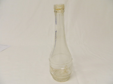
Bottle - Spirits, 1940's - 1950's
Gin came in bottles sold at licensed premises either locally or in larger cities visited during shopping expeditions. The shape of bottles varied and were re cycled remaining the property of the manufacturer who paid for their return. Sealed with a cork. History of H & A Gilbeys Ltd.Historical: Change of bottles - shape, glass, embossing. Collected by bottle collectors. Aesthetic: Display showing embossing and shape.Clear glass bottle with a mottled pattern except on one side where there is a clear rectangle and above it the shape of an elongated heart. The other side is heavily embossed with manufacturer. The first 2 lines across the bottle printed in capital letters below which is the manufacturer written as a signature and Ltd underneath. The shape bulges from the base one third of the way up then tapers gently for the second third to a straight neck. The top third finishing at the lip before the opening. At the bottom there is a short taper to a smaller base. the opening is for a cork seal.Side: 'This Bottle Always / Remains The Property of / J & A Gilbey / Ltd.' Base: centre: '2'gin, spirits, bottle, h & a gilbeys ltd -
 Kiewa Valley Historical Society
Bottle - Spirits, 1940's
Spirits came in bottles sold at licensed premises either locally or in larger cities visited during shopping expeditions. The shape of bottles varied and were re cycled remaining the property of the manufacturer who paid for their return. History of the Distillery Corporation.Historical: Change of bottles - shape, glass, embossing. collected by bottle collectors Aesthetic: Display showing variations of shape and embossingClear smooth glass bottle almost rectangular but with curved sides and corners. Long straight sides three quarters of the way up tapering to a short straight neck separated by a lip to the opening. Lightly embossed at the front towards the bottom. It has 4 lines of print in capital letters. The base is curved inwards and therefore rounded. Used for storing rum.Side: 'This Bottle / Is the Property / of the / Distillery Corporation (?)' Base: '122' and '0'rum, glass bottle, drink, distillery corporation, spirits -
 Kiewa Valley Historical Society
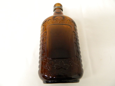
Bottle - Spirits, 1950's -1960's
Spirits came in bottles sold at licensed premises either locally or in larger cities visited during a shopping expedition. The shape of bottles varied and were re cycled remaining the property of the manufacturer who paid for their return. History of Thomas Hardy & Sons Pty Ltd.Historical: Change of bottles - shape, glass, embossing. Collected by bottle collectors. Aesthetic: Display showing embossing and shape. Clear dark brown glass bottle used for storing whisky or rum. the base is oval shaped. The sides are straight three quarters of the way up then tapers quickly to the neck and then a lip near the opening. the fort & back sides have smooth rectangular shapes bordered by heavy embossing of grapes. On the sides heavy embossing of horizontal ripples. embossed front and back print at bottom and at base. Strip of metal around the bottle at the top of the neck (remainder of the seal).Base, front and back sides: 'This Bottle is the Property of / Thos Hardy & Sons Pty Ltd'glass bottle, whisky, rum, spirits, thomas hardy & sons pty. ltd -
 Kiewa Valley Historical Society
Article - "This Week" - History of Green Tea, Green Tea - The Facts
'The Japanese company Ito En has been working solidly for the last five years to establish a green tea industry in this area .' The article includes assistance from the Alpine Shire, the cost and benefits of the schemeThis is of historic and social significance regarding industries in Mt Beauty and the Kiewa Valley especially as some no longer grow green tea as the affect of bush fires (smoke) made the industry not viable.Article with Title "Green Tea - The Facts" published on Page Seven from local publication "This Week" Falls Creek. Bogong. Mt. Beauty Summer Edition 21 Friday January 23rd 2004. Refers to properties of which there are 50% in the Kiewa Valley including Mt Beauty.green tea in mt beauty, japanese company ito en -
 4th/19th Prince of Wales's Light Horse Regiment Unit History Room
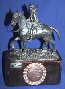
Memorabilia - Trophy, NLT 1977
Object is property of the Regiment. It has been catalogued by the Unit History Room to provide a record of it.Cast metal 230 mm high statuette of a mounted Australian Lighthorseman on a solid wooden base, dark brown varnish finishUnderneath: "4/19 PWLH Challenge Cup" 47 x 20 mm plaque affixed to front:"LCPL B DAWSON 8225381 4-Section 2013" On front of mounting block, 100 mm circular metal plaque surrounded by laurel wreath "Presented by the 4th Light Horse Regt 1st AIF Association to the 4th-19th Prince of Wales Light Horse Regt."statuette, 4th light horse -
 4th/19th Prince of Wales's Light Horse Regiment Unit History Room
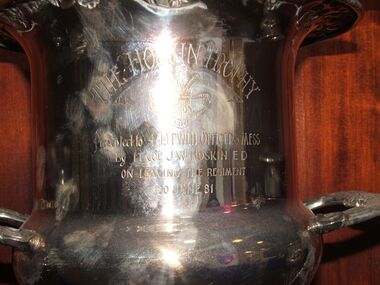
Award - Silver Trophy, Rodd, The Hoskin Trophy, abt 1981
Property of former 4/19 PWLH Regiment Officers MessPresented by a former Commanding Officer of the RegimentEngraved silver plated cup with 2 handles. Flared top with embossed floral design around rim.Presented to 4/19 PWLH Officers Mess by Lt Col J W Hoskin ED on leaving the Regiment 20 June 81trophy, cup, officers mess, hoskin -
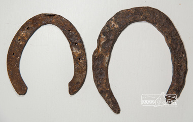 Eltham District Historical Society Inc
Horseshoe, Two horseshoes, c.1860, 1860s
ELTHAM POLICE QUARTERS & REAR STABLE (FORMER), is listed on the Victorian Heritage Database. The stables are described: "The original single stall brick stables building with loft, built in 1859-60.."These horseshoes were dug up by the owners of the property adjoining the former Eltham Police Station and Court House site behind the stables when working in their garden. Presumably they were discarded adjacent to the stables where the Police horses were kept and over time became covered with soil and other material. They were presented to the Society by the owner during the Local History Centre Open Day held for the Society's 50th anniversary 4 March 2017.Two iron (rusty) horsehoes, one significantly larger than the other; the larger shoe appearing to be not fully manufactured as no nail holeshorseshoe, police residence, police station, brougham street, eltham -
 Eltham District Historical Society Inc
Ledger, Eltham Road District. Assessment for the Year ending Oct. 14th, 1858, 1857c
The Eltham Roads Board was established in 1856. This is a unique significant record of early settlers in the Shire of Eltham. One of 6 early rate books. This is among the oldest items in the EDHS collection. An article in the Eltham and Whittlesea Shires Advertiser Friday 21 Nov 1941 Page 5 titled: District's Early History states: "The first rate book which is still in existence at the Shire Office is for the year ending October 14, 1858 and is probably the best record possible to indicate the development of the district. At the time properties were rated as follows: Cultivated land. 6d. per acre; pasture land, 1d. per acre: estimated annual value of buildings, etc., 6d in the (pound). The total amount of rate recorded for the year was (pounds)153/14/8. Properties were described as being situated at Lower Plenty, Yarra Yarra, Eltham, Lower Eltham, Kangaroo Ground, Yarra Flats, Diamond Creek and the Yarra."Ledger with printed columns: Number, Name of Occupier, Description, Where situated, Cultivated land, Pasture land, Estimated annual value of buildings, Rate, Remarks. Ledger filled out by hand with 152 entries (not alphabetically arranged). A number of blank pages are included. Copy re-bound in green hard leather look card by Arnall & Jackson Pty Ltd Brunswick, 1968 Inside cover includes a compliments slip taped to the cover from Arnall & Jackson Pty Ltd. with handwritten inscription: "Ian, I hope the hysterical society doesn't get historical about this". Organised 1968 I. Maynard Inside cover includes pasted printed note: RATE OF ASSESSMENT AS FOLLOWS: Cultivated land 6d per acre Pasture land 1 per acre Estimated Annual Value of Buildings, &c., 6d. in the Pound eltham roads board, rate book, rate payers, transaction, pioneers, settlers, 1858, assessment ledger, eltham road district, public records office victoria (prov), rate books, shire of eltham archives -
 Eltham District Historical Society Inc
Ledger, Eltham Road District. Assessment for the Year ending Oct. 14th, 1859, 1858c
The Eltham Roads Board was established in 1856. This ledger includes the signature of Road Board Secretary and Collector Wingrove, a significant person in Eltham's early history. This is a unique significant record of early settlers in the Shire of Eltham. One of 6 early rate books. This is among the oldest items in the EDHS collection. An article in the Eltham and Whittlesea Shires Advertiser Friday 21 Nov 1941 Page 5 titled: District's Early History states: "The first rate book which is still in existence at the Shire Office is for the year ending October 14, 1858 and is probably the best record possible to indicate the development of the district. At the time properties were rated as follows: Cultivated land. 6d. per acre; pasture land, 1d. per acre: estimated annual value of buildings, etc., 6d in the (pound). The total amount of rate recorded for the year was (pounds)153/14/8. Properties were described as being situated at Lower Plenty, Yarra Yarra, Eltham, Lower Eltham, Kangaroo Ground, Yarra Flats, Diamond Creek and the Yarra."Ledger with printed columns: Number, Name of Occupier, Description, Where situated, Cultivated land, Pasture land, Estimated annual value of buildings, Rate, Remarks, Arrears collected, excused, unoccupied, uncollected and amount actually collected. Ledger filled out by hand with 173 entries (not alphabetically arranged). A number of blank pages are included. Inside cover includes pasted printed note: RATE OF ASSESSMENT AS FOLLOWS: Cultivated land 6d per acre Pasture land 2d per acre Unalienated Pasture Land 8d per Acre Estimated Annual Value of Buildings, &c., 6d. in the Pound eltham roads board, rate book, rate payers, transaction, pioneers, settlers, wingrove, 1859, assessment ledger, eltham road district, public records office victoria (prov), rate books, shire of eltham archives -
 Eltham District Historical Society Inc
Ledger, Eltham Road District. Assessment for the Year ending Oct. 14th, 1860 (Version 1), 1859c
The Eltham Roads Board was established in 1856. This is a unique significant record of early settlers in the Shire of Eltham. One of 6 early rate books. This is among the oldest items in the EDHS collection. An article in the Eltham and Whittlesea Shires Advertiser Friday 21 Nov 1941 Page 5 titled: District's Early History states: "The first rate book which is still in existence at the Shire Office is for the year ending October 14, 1858 and is probably the best record possible to indicate the development of the district. At the time properties were rated as follows: Cultivated land. 6d. per acre; pasture land, 1d. per acre: estimated annual value of buildings, etc., 6d in the (pound). The total amount of rate recorded for the year was (pounds)153/14/8. Properties were described as being situated at Lower Plenty, Yarra Yarra, Eltham, Lower Eltham, Kangaroo Ground, Yarra Flats, Diamond Creek and the Yarra."Ledger with printed columns: Number, Name of Occupier, Description, Where situated, Cultivated land, Pasture land, Estimated annual value of buildings, Rate, Remarks, Arrears collected, excused, unoccupied, uncollected and amount actually collected. Ledger filled out by hand with 177 entries (not alphabetically arranged). A number of blank pages are included. Inside cover includes pasted printed note: RATE OF ASSESSMENT AS FOLLOWS: Cultivated land 6d per acre Pasture land 2d per acre Unalienated Pasture Land 8d per Acre Estimated Annual Value of Buildings, &c., 6d. in the Pound eltham roads board, rate book, rate payers, transaction, pioneers, settlers, wingrove, 1860, assessment ledger, eltham road district, public records office victoria (prov), rate books, shire of eltham archives -
 Eltham District Historical Society Inc
Ledger, Eltham Road District. Assessment for the Year ending Oct. 14th, 1860 (Version 2), 1859c
The Eltham Roads Board was established in 1856. This is a unique significant record of early settlers in the Shire of Eltham. One of 6 early rate books. This is among the oldest items in the EDHS collection. An article in the Eltham and Whittlesea Shires Advertiser Friday 21 Nov 1941 Page 5 titled: District's Early History states: "The first rate book which is still in existence at the Shire Office is for the year ending October 14, 1858 and is probably the best record possible to indicate the development of the district. At the time properties were rated as follows: Cultivated land. 6d. per acre; pasture land, 1d. per acre: estimated annual value of buildings, etc., 6d in the (pound). The total amount of rate recorded for the year was (pounds)153/14/8. Properties were described as being situated at Lower Plenty, Yarra Yarra, Eltham, Lower Eltham, Kangaroo Ground, Yarra Flats, Diamond Creek and the Yarra."Ledger with printed columns: Number, Name of Occupier, Description, Where situated, Cultivated land, Pasture land, Estimated annual value of buildings, Rate, Remarks, Arrears collected, excused, unoccupied, uncollected and amount actually collected. Ledger filled out by hand with 177 entries (not alphabetically arranged). A number of blank pages are included. This version was slight changes to version one. Inside cover includes pasted printed note: RATE OF ASSESSMENT AS FOLLOWS: Cultivated land 6d per acre Pasture land 2d per acre Unalienated Pasture Land 8d per Acre Estimated Annual Value of Buildings, &c., 6d. in the Pound eltham roads board, rate book, rate payers, transaction, pioneers, settlers, 1860, assessment ledger, eltham road district, public records office victoria (prov), rate books, shire of eltham archives -
 Eltham District Historical Society Inc
Ledger, Eltham Road District. Assessment for the Year ending Oct. 14th, 1861, 1860c
The Eltham Roads Board was established in 1856. This is a unique significant record of early settlers in the Shire of Eltham. One of 6 early rate books. This is among the oldest items in the EDHS collection. An article in the Eltham and Whittlesea Shires Advertiser Friday 21 Nov 1941 Page 5 titled: District's Early History states: "The first rate book which is still in existence at the Shire Office is for the year ending October 14, 1858 and is probably the best record possible to indicate the development of the district. At the time properties were rated as follows: Cultivated land. 6d. per acre; pasture land, 1d. per acre: estimated annual value of buildings, etc., 6d in the (pound). The total amount of rate recorded for the year was (pounds)153/14/8. Properties were described as being situated at Lower Plenty, Yarra Yarra, Eltham, Lower Eltham, Kangaroo Ground, Yarra Flats, Diamond Creek and the Yarra."Ledger with printed columns: Number, Name of Occupier, Description, Where situated, Cultivated land, Pasture land, Estimated annual value of buildings, Rate, Remarks, Arrears collected, excused, unoccupied, uncollected and amount actually collected. Ledger filled out by hand with 185 entries (not alphabetically arranged) and summary section. A number of blank pages are included. Inside cover includes pasted printed note: RATE OF ASSESSMENT AS FOLLOWS: Cultivated land 6d per acre Pasture land 2d per acre Unalienated Pasture Land 8d per Acre Estimated Annual Value of Buildings, &c., 6d. in the Pound eltham roads board, rate book, rate payers, transaction, pioneers, settlers, 1861, assessment ledger, eltham road district, public records office victoria (prov), rate books, shire of eltham archives -
 Eltham District Historical Society Inc
Ledger, Eltham Road District. Assessment for the Year ending Oct. 14th, 1862, 1861c
The Eltham Roads Board was established in 1856. This is a unique significant record of early settlers in the Shire of Eltham. One of 6 early rate books. This is among the oldest items in the EDHS collection. An article in the Eltham and Whittlesea Shires Advertiser Friday 21 Nov 1941 Page 5 titled: District's Early History states: "The first rate book which is still in existence at the Shire Office is for the year ending October 14, 1858 and is probably the best record possible to indicate the development of the district. At the time properties were rated as follows: Cultivated land. 6d. per acre; pasture land, 1d. per acre: estimated annual value of buildings, etc., 6d in the (pound). The total amount of rate recorded for the year was (pounds)153/14/8. Properties were described as being situated at Lower Plenty, Yarra Yarra, Eltham, Lower Eltham, Kangaroo Ground, Yarra Flats, Diamond Creek and the Yarra."Ledger with printed columns: Number, Name of Occupier, Description, Where situated, Cultivated land, Pasture land, Estimated annual value of buildings, Rate, Remarks, Arrears collected, excused, unoccupied, uncollected and amount actually collected. Ledger filled out by hand with 184 entries (not alphabetically arranged) and summary section. A number of blank pages are included. Inside cover includes pasted printed note: RATE OF ASSESSMENT AS FOLLOWS: Cultivated land 6d per acre Pasture land 1/2d per acre Unalienated Pasture Land 1/28 per Acre Estimated Annual Value of Buildings, &c., 6d. in the Pound eltham roads board, rate book, rate payers, transaction, pioneers, settlers, 1862, assessment ledger, eltham road district, public records office victoria (prov), rate books, shire of eltham archives -
 Eltham District Historical Society Inc
Ledger, Eltham Road District. Assessment for the Year ending Oct. 14th, 1863, 1862c
The Eltham Roads Board was established in 1856. This is a unique significant record of early settlers in the Shire of Eltham. One of 6 early rate books. This is among the oldest items in the EDHS collection. An article in the Eltham and Whittlesea Shires Advertiser Friday 21 Nov 1941 Page 5 titled: District's Early History states: "The first rate book which is still in existence at the Shire Office is for the year ending October 14, 1858 and is probably the best record possible to indicate the development of the district. At the time properties were rated as follows: Cultivated land. 6d. per acre; pasture land, 1d. per acre: estimated annual value of buildings, etc., 6d in the (pound). The total amount of rate recorded for the year was (pounds)153/14/8. Properties were described as being situated at Lower Plenty, Yarra Yarra, Eltham, Lower Eltham, Kangaroo Ground, Yarra Flats, Diamond Creek and the Yarra."Ledger with printed columns: Number, Name of Occupier, Description, Where situated, Cultivated land, Pasture land, Estimated annual value of buildings, Rate, Remarks, Arrears collected, excused, unoccupied, uncollected and amount actually collected. Ledger filled out by hand with 181 entries (not alphabetically arranged) and summary section. A number of blank pages are included. Inside cover includes pasted printed note: RATE OF ASSESSMENT AS FOLLOWS: Cultivated land 6d per acre Pasture land 1/2d per acre Unalienated Pasture Land 1/28 per Acre Estimated Annual Value of Buildings, &c., 6d. in the Pound eltham roads board, rate book, rate payers, transaction, pioneers, settlers, 1863, assessment ledger, eltham road district, public records office victoria (prov), rate books, shire of eltham archives -
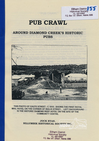 Eltham District Historical Society Inc
Book, Nillumbik Historical Society, Pub Crawl: around Diamond Creek's historic pubs by Jock Ryan, 2001
Hotels described include: Evelyn Arms Hotel or Tunnel Camp Hotel or Half-Way House, the Diamond Reef Hotel, the Loyal Diamond Lodge Hotel and the Royal Mail Hotel all located in Diamond Creek during a rapid population growth in Diamond Creek in the 1860s.This small publication discusses the history of local hotels in the Diamond Creek area during a significant period of development in the 1860s when mining took place in the local area. The history of hotels connects to the wider history and important social and civic link to the community at that time. [10] p. includes text and very poor photocopy reproductions of historical photographs. Perfect bound with plastic front cover only.EDHS Property stamp on front coverdiamond creek, hotels, pubs, bars, 1860s -
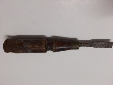 Warrnambool and District Historical Society Inc.
Tools, Chisel, Late 19th century/early 20th century
This chisel belonged to Ernest Brighton Phillips, a Warrnambool furniture maker. Ernest Phillips (1875-1924) was born in Warrnambool and was apprenticed as a cabinet maker at the Warrnambool Box Works. In the 1890s he established a furniture store at the corner of Liebig and Koroit Streets and by the 20th century he had the largest furniture warehouse and factory in Victoria outside Melbourne. His products were sold all over Australia. Ernest Phillips and his family lived at ‘Heatherlie’ in Koroit Street. Today this property is the site of the residential complex for senior citizens known as ‘Heatherlie’. This chisel is of interest as it belonged to Ernest Phillips, a prominent businessman in Warrnambool at the end of the 19th century and the beginning of the 20th century. The item is also of interest as it is a good example of a woodworking tool that was used 100 years ago. This is a chisel with a wooden handle and a metal blade flattened at the end and attached to the handle by a brass ring. The blade is rusty and the handle has some of the wood gouged out at the top end. The handle has splotches of paint on it. The name of the owner, E. Phillips, is stamped into the wood. ‘E. Phillips’ernest phillips, history of warrnambool, warrnambool -
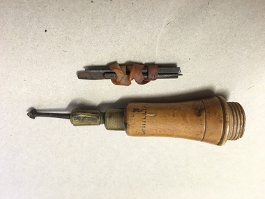 Warrnambool and District Historical Society Inc.
Tools, Hand Working Tool, Late 19th century/early 20th century
This tool belonged to Ernest Brighton Phillips, a Warrnambool furniture maker. Ernest Phillips (1875-1924) was born in Warrnambool and learnt his carpentry trade at the Warrnambool Box Works. In the late 1890s Phillips established a furniture store at the corner of Liebig and Koroit streets and by the early 20th century he had the largest furniture warehouse and factory in Victoria outside of Melbourne. His products were sold all over Australia. Phillips and his family lived at ‘Heatherlie’ in Koroit Street. Today this property is the site of the residential complex for senior citizens known as ‘Heatherlie’. This tool is of considerable interest as it belonged to Ernest Phillips, a prominent businessman in Warrnambool at the end of the 19th century and the beginning of the 20th century. It is also of interest as a good example of a tool that was in use 100 years ago. This is a small tool with a wooden handle. The top part of the handle that screws in is missing. The tool is attached to the handle by a brass ring and a screw and the tool itself is a thin nail-like piece of metal with a small metal piece at the end in the shape of a star with six points. This end piece gouges out a hole or a pattern in wood or other hard material. The tool belonged to Ernest Phillips and his name is stamped on the handle. Three oblong-shaped metal nails were also with this tool but were not necessarily used with it. ‘E. Phillips’ernest phillips, history of warrnambool -
 Warrnambool and District Historical Society Inc.
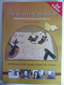
Book, Streets of Hamilton, 2007 (revised and reprinted 2009)
This is a book providing information on the streets of Hamilton, Victoria and the origin of the names. Hamilton is a city in Western Victoria at the intersection of the Glenelg Highway and the Henty Highway. European settlement began with the arrival of pastoralists following the 1836 explorations of Major Thomas Mitchell. The Wedge family in 1839 had the property ‘The Grange’ which covered the site of Hamilton today. The town was gazetted in 1851 and named after a place in Scotland. Hamilton Victoria is the centre of a sheep-grazing and agricultural district. The book won an award in the 2008 Victorian Community History Awards. This book is of interest as it gives information on the Hamilton streets and the origin of their names. The history of Hamilton is of particular interest to those also living in the Western District. The book will be a useful research tool. This is a soft cover book of 174 pages. The back cover has a white background with black and white photographs of five local Hamilton people. The front cover has a yellow and brown background with black and white photographs of five local Hamilton people, an outline of a map of Victoria and a photograph of a map of the Hamilton area with some artefacts placed on the map. The book contains an Introduction, a Preface, a Foreword, an Early Days Overview, a list of Contents, a list of the streets in alphabetical order with information on the origin of the names, two Appendices and an Index. The book has many black and white photographs and sketches. Front Cover: ‘2nd Edition’ ‘The Streets of Hamilton’ ‘Western Victoria Australia’ ‘By John McKay’ ‘A History of the People behind the Names’hamilton, victoria, john mckay, street names of hamilton, warrnambool -
 Warrnambool and District Historical Society Inc.
Documents, Technical Drawings Feed Pump
These drawings have been produced in 1919 by Ron Uebergang when he was a pupil at the Warrnambool Technical School. The Uebergang families were pioneers in the Warrnambool/Allansford area. Ronald Uebergang (1903-1971) was born in Warrnambool to Ernest Uebergang and Mary Watson. He went to Allansford State School and Warrnambool Technical School and married Myra Hall. He was mechanically-minded, a good photographer and fond of music and dancing. He and Myra had a dairy farm at the family property, Hopkins Hill near Allansford and later took up grazing beef cattle. Warrnambool Technical School was established in 1913, and was located first on a Timor Street site and later moved to Caramut Road. Today it is called Brauer College. These drawings are of considerable interest because they were produced by Ron Uebergang and the Uebergang families have been prominent in the history of the Warrnambool and Allansford areas since the 1850s. They are also of interest as examples of the type of work produced by students of Warrnambool Technical School in its early days. .1 A Blueprint for a Feed Pump for a Horizontal Engine - blue background, white drawings. The drawing is two-thirds of the full size object. .2 The same drawing on white see-through paper. The paper has a thick line drawn around the edges in black ink. .3 The same drawing on plain white card with drawings in black ink and a thick line drawn around the edges in black ink. .4 The original brown paper covering used to send the drawings to Warrnambool Technical School in 1921. There are also two pages of handwritten material attached to the drawings by a metal clip and giving a description of the design of the Feed Pump. ‘Warrnambool Technical School’ ‘Designed by R. Uebergang’ ‘Drawn by R. Uebergang’ ‘Date 7/10/19’ ronald uebergang, warrnambool technical school, history of allansford, history of warrnambool -
 Warrnambool and District Historical Society Inc.
Note Book, Engineering Drawings, 1919-21
This note book contains handwritten material by Ron Uebergang – notes on engineering drawings prepared for a class at Warrnambool Technical School 1919-1921. Ronald Uebergang (1903-1971) was the son of Ernest and Mary Uebergang. He attended Allansford State School and Warrnambool Technical School and spent his working life dairying and raising cattle on the family property, Hopkins Hill, at Allansford, about nine kilometres east of Warrnambool. He was mechanically minded, fond of music and dancing and a keen photographer. These notes are of interest as they were compiled by Ron Uebergang when he was a student at Warrnambool Technical School 1919-21. The Uebergang families were pioneering settlers in the Allansford area and have been prominent farmers in the area from the 1850s on. The notes also are a good example of the work done by students at Warrnambool Technical School in the 1920s. This is a hand-made book of 22 pages with notes on engineering drawings by Ron Uebergang handwritten in black ink. There is tissue paper inserted between some of the pages. There are several drawings and equations in with the handwritten material. There is some silver fish damage on the front cover. Front Cover: ‘R. Uebergang’ ‘Note Book for Engineering Drawing Grade 3’ ronald uebergang, warrnambool technical school, history of allansford, history of warrnambool -
 Warrnambool and District Historical Society Inc.
Book, Chambers’s Journal 1874, 1874
This is a book given to Margaret Davidson in 1875 by her aunt, Mrs J. Davidson. Margaret Milne Davidson (1839-1928) was the eldest child of James and Isabella Davidson and she was born in Kirriemuir, Scotland. She came to the Warrnambool area in 1850. The property, ‘Woodend’, was near Cassadys Bridge (Caramut Road today). The aunt, Mrs J. Davidson would be the wife of John Davidson, the brother of James and a farmer at ‘Rosebank’, Woodford. The portraits of John and James Davidson are on the Warrnambool Pioneer Honour Board. This book is of interest because of its inscription. The book is connected to the Davidson families, prominent in Warrnambool’s pioneer history.This is a hard cover book of 832 pages. The book has a dark green cover with dark green and gold lettering with ornamental gold surrounds. The book has an index, short stories, poems, essays and articles on science and the arts. The book contains monthly journals for 1874 combined in one volume. The cover is stained and blotched. There are several stamps of the Warrnambool & District Historical Society. The inscription on the first page is handwritten in black ink. ‘Margaret M. Davidson, Woodend, from her aunt, Mrs J. Davidson, 30/9/75’.margaret davidson, james and john davidson, history of warrnambool -
 Warrnambool and District Historical Society Inc.
Book, Third Book, Late 19th century
This little book is very old, presumably 19th century, but the wording on the front cover is indecipherable, no date is evident and the first and last pages are missing. The book was owned by Mary Jane Freckleton with the main inscription written in an adult hand – ‘Mary Jane Frickelton, Mailers Flat’. The spelling of Mailers Flat with an ‘e’ was not a mistake but this was the common spelling in the 19th century and the early 20th century. According to the Freckleton family history ‘Freckleton’ was sometimes spelled ‘Frickelton’ or ‘Frickleton’. Mailors Flat is nine kilometres from Warrnambool and the Mailors Flat School, number 1210, was opened in 1872 in Caramut Road and closed in 1994. The first Head Teacher was Julian Castles. There were Freckelton families in the 19th century in Port Fairy, Caramut, Woolsthorpe, Woodford and Mailors Flat. The Freckletons at Mailors Flat were engaged in farming. Mary Jane Freckleton was for a time a pupil teacher at Mailors Flat School. She was born at the Injemira property and married Henry Giles. This is an interesting book because of its age and because it belonged to Mary Jane Freckleton, a member of the Freckleton families, early settlers in the areas north of Warrnambool. She may have used the book when she was a pupil teacher at the Mailors Flat School. This is a hard cover book of 284 pages (some pages missing). The cloth cover is brown and much torn and stained. There are 86 chapters of prose and verse and a sprig of dried flowers is enclosed in the pages. There is the red stamp of the Warrnambool & District Historical Society on the first page and several snippets of writing in black ink on the front and back pages.‘Mary Jane Frickelton Mailers Flat’mary jane freckleton, mailors flat school -
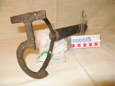 Warrnambool and District Historical Society Inc.
Functional object - Farming Equipment Branding Iron, Circa 1840
Armyne, George and Lemuel Bolden were original landholders of large parts of land in the Western district. Portions of it extended from Pirron Yallock in the East to almost as far as Portland. The head station was at Grasmere. They were noted breeders of shorthorn cattle in fact they were some of the first men to bring the breed to Victoria and thus helped to pioneer the Australian Shorthorn breeding Industry. This branding iron was found at Lyall Park, originally 640 acres selected by William Lyall at Cooramook. It is believed to be a branding iron dating from when the land was occupied by the Bolden Brothers. The Bolden Brothers were the first to erect considerable lengths of fencing in the Warrnambool area. If this item is an authentic Bolden piece of property then it is the oldest artefact from the time of white settlement that is held by the Warrnambool and district Historical society. The item itself while a common farming implement and which was found on a farm originally owned by the Bolden Brothers is a link with the earliest part of Warrnambool’s history.Short, round wooden handle with metal brand in the shape of the letter T with two thirds circle attached to vertical part of T. Daub of paint at end of handle . T 5Paper label attached with green tape with 931 in texta and hand written on back,” branding iron reputed to have been used by Bolden Bros Grasmere c 1840. warrnambool, bolden brothers, armyne bolden, george bolden, lemuel bolden, branding iron, shorthorn cattle