Showing 1233 items matching "the gap"
-
 Halls Gap & Grampians Historical Society
Photograph - Coloured, C Oct 1985
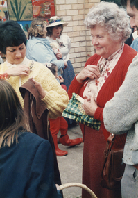
The photo is taken outside the Halls Gap Hall. A parade was held in conjunction with the 150th anniversary of Major Mitchell's visit, together with the unveiling of a plaque commemorating the Wildflower Show and its many volunteers.The photo shows people chatting. There is a brick wall with a mural displayed on it in the background. Two women in the foreground are pinning sprigs of thryptomene to their apparel.events, wildflower show -
 Halls Gap & Grampians Historical Society
Photograph - B/W, C Oct1950
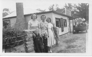
A photo taken near Thomson's Store & cafe in Halls Gap. The back of the photo lists the names of the people as: Mollie Johnson, Gwen Stockton, Beth Evans, Julie D'Alton & Joy Stockton.The photo shows three women and two girls standing in front of a stone fence. There is a bush on the left behind the fence and to the right of the photo is a store with a truck loaded with drums and sacks and a wooden box of goods."Rose I(?) Oct 1950" written on back in blue pen. "Mollie Johnson, Gwen Stockton, Beth Evans, Julie D'Alton,Joy Stockton" written on bak in black pen.buildings, shops -
 Hume City Civic Collection
Photograph, early 1980s
The photograph shows the extent of Sunbury's development to the west of the town in the early 1980s. The settlement at this stage extended along either side of Gap Road for about 0.5 km beyond Elizabeth Drive.A coloured landscape photograph with rounded corners taken from Mt. Holden and looking towards the expanding town of Sunbury. The Melba Avenue drain which flows into Blind Creek is in the foreground. Sheoak Hill, the site of the former Sunbury Asylum is in the middle of the skyline.sunbury township, reservoir road, mt. holden, sunbury asylum, george evans collection -
 Stawell Historical Society Inc
Archive - Advertising Material, Wonerland Run Gariwerd, 2021
Absolute freaking intensity! You are IN the landscape, and on top of the world. It will chew you up, Spit you out, and you'll love it. All events based from Halls Gap in the mighty Grampians.Colour Card - line drawing of mountain range - rainbow sky with lightning bolt, trees. Name rises out of rock.August 28 & 29 2021 WWW. wonerlandrun.com.au Sat. *km run Fyans Flat Fubn Run / 2 km Venus Baths Run. Sun 20k sundialers, 36k Rosea Run, 60k Wonerland Run -
 Stawell Historical Society Inc
Photograph, Bridge Building -- Possibly Delley's Bridge c1901
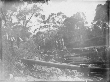
Photo of 3 women with a dog standing on a bridge with 5 men possible working on the Bridge in the Grampians. Photo taken in the area where Delley’s Bridge now stands, Hall’s Gap. c1901Sepia Post Card depiction people around a log bridge over a waterway in bush setting.Post Cardstawell -
Stawell Historical Society Inc
Book, Kenneth & Esther Stepnell, The Grampians in colour, 1972
1972 - Colour photgraphs of Grampians Ranges, Lake Bellfield, Fauna, signpost, Halls Gap, Rockart, Flora. Kenneth Stepnell Photographer. Esther Stepnell selected the photographs and wrote the introduction & captions.Hardcover with Dustjacket: Colour photo of a man overlooking a valley with lake Bellfield from the Pinnacle lookout.Inside: Name and address of previous ownergrampians, touruism -
 Orbost & District Historical Society
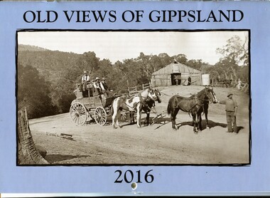
calendar, Old Views of Gippsland 2016, 2015
This item is one of a series of calendars compiled and published by East Gippsland Historical Society.This item is a useful reference toolA 2016 stapled calendar, titled "Old Views of Gippsland". On the light blue coloured front is a black/white photograph of Tongio Gap, Omeo, showing Mitchell's coach which ran from Bairnsdale to Omeo. The calendar contains early photographs of East Gippsland, one for each month. There is a hole for hanging. The title is at the top and the year at the bottom in black print. calendar-old-views-gippsland photographs-histporic-gippsland -
 Stawell Historical Society Inc
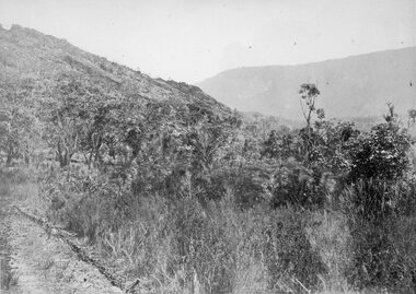
Photograph, Grampians Entrance to Halls Gap 1866
Grampians Entrance to Halls Gap. Part of a collection of Photographs by Mr. O.G. Armstrong as commissioned by the Shire of Stawell for the Inter-colonial and Paris Exhibition in Melbourne in 1866. Halls Gap is named after Charles Browning Hall. In his letter to Joseph Latrobe he gives no clue about his early life except that he was a stock herder as early as 1837. He held two runs in the Wimmer district, that of La Rose and Mokebila in the Grampians (1841 to 1842). He then moved to the Clunes area in 1851. He was a member of the Carisbrook Magistrates Bench. stawell -
 Halls Gap & Grampians Historical Society
Photograph - B/W, Oct-86
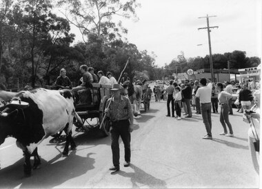
The bullock team was part of a parade held on the main street of Halls Gap in conjunction with the 150th anniversary of Major Mitchell's visit to the area. There was also a plaque unveiled in commemoration of the Wildflower Show and its many volunteers.The photo shows a crowd watching a bullock team hauling a dray with five children sitting in it down a road. The bullock driver is walking alongside holding a long handled whip over his shoulder. A wagon pulled by draught horses can be seen behind the bullock dray. Buildings can be seen to the right rear of the photo and trees line the left side of the street.events, parades -
 Halls Gap & Grampians Historical Society
Photograph - B/W, Oct-86
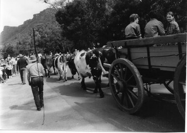
The bullock team was part of a parade held on the main street of Halls Gap in conjunction with the 150th anniversary of Major Mitchell's visit to the area. There was also a plaque unveiled in commemoration of the Wildflower Show and its many volunteers.The photo is taken from the rear of a bullock team pulling a dray down a road. Three children can be seen sitting in the dray and its back is out of shot. Two men are walking to the left of the team, the closest to the camera holding a long whip over his shoulder. To the far left people can be seen lining the street and in the right background a range of peaks can be seen.events, parades -
 Sunbury Family History and Heritage Society Inc.
Photograph, Rosa McCall, Sunbury Cemetery, 2014
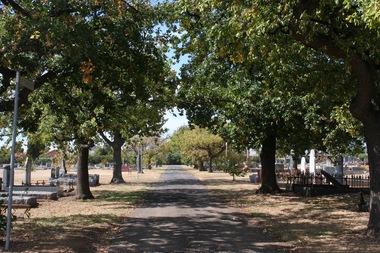
The photograph was taken in the older section of Sunbury Cemetery, which was laid out in denominal sections in 1862. It replaced the building of a cemetery that was planned at The Gap. Some of the cemetery's older graves and headstones are along the avenue in the image.Sunbury Cemetery is one of the earliest cemeteries to be established and still functioning in the areaA non-digital coloured photograph of an avenue of trees in a cemetery with graves on both sides of the path.sunbury cemetery, cemeteries, memorials -
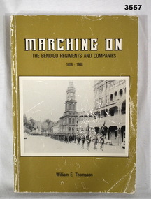 Bendigo Military Museum
Book - BOOK, BENDIGO REGIMENTS, Marching On, Post 1960
Marching On - The Bendigo Regiments and Companies 1858 - 1988. From Preface: This book is a brief outline of the history of the numerous military companies and battalions from 1958 to 1988. This book should fill a gap in the military events of Bendigo.Soft cardboard cover. Black / white print on front, spine & back. Brownish yellow background colour, illustrated with black / white photos. On the front soldiers are marching with buildings in the background. On the back is a half portrait of 3 men in uniform. 194 cut, plain, white, pages. Illustrations &black / white photos.Handwritten in blue ink on title page: “W Thomason”book, bendigo, regiments, companies -
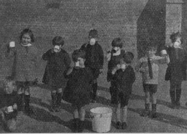 Halls Gap & Grampians Historical Society
Photograph - B/W
During the 1940's and 1950's, all State Primary Schools gave students fresh milk during the 'summer' months. In the Hall's Gap/Stawell area hot cocoa was given to the students in 'winter' months.The photo shows a group of nine primary school students drinking from mugs. Eight children are standing and one is squatting down. They are in a yard and there is a light coloured pail in the centre.education, schools -
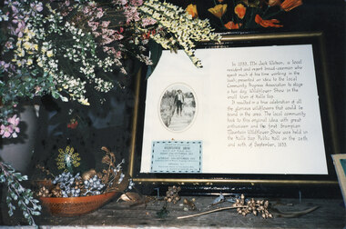 Halls Gap & Grampians Historical Society
Photograph - Coloured
Part of a display at the 1992 Wildflower Show. The historical description relates to Jack Watson, the convenor of the first Wildflower Show in 1933. For further information about Jack Watson see "Bridging the Gap", pp 88 & 91.The photo shows a framed historical description about Mr Jack Watson, including an oval photo and a blue "Wildflower Show" admission ticket. On the left of the photo, beside the frame, is a display of wildflowers in a vase and a dried display beneath it in a basket/bowl.events, wildflower show -
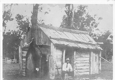 Halls Gap & Grampians Historical Society
Photograph - B/W, c 1850s
This windowless bark hut would have been used by stockmen who looked after sheep and cattle in the Fyans Valley. This hut was situated at the site later named the Borough Huts. See p8 Bridging the Gap Photo shows a man sitting outside a wooden slab hut. The hut has a tin flashing along top roof line. Man is wearing a hat and tie. A gun is leaning up against wall of hut. A sheep or cattle race can be seen in left corner of photo. buildings, houses -
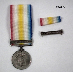 Bendigo Military Museum
Award - MEDAL & SERVICE RIBBONS, BCOF
Medal and ribbon for Foreign Service awarded to service in Occupation of Japan by BCOF. Item in the collection of Richard William McGILVERY, RAAF. Refer Cat No. 7287P for his service details. This medal and ribbon are not part of Defence Honors and Awards.1. Round Service Medal, silver, roaring lion on front and picture of crossed spears with flags through a shield and wings at bottom, connecting to a clasp with occupation of Japan and threaded with ribbon that is red, white, yellow and blue. 2, Small ribbon, red, white, yellow and blue. 3. Small silver clasp with gap to thread a ribbon and inscribed on front is Occupation of Japan.1. Inscribed for "For Foreign Service". Clasp has "Occupation of Japan" inscribed on it. 3. Inscribed "Occupation of Japan", bcof, foreign service medal, richard william mcgilvery -
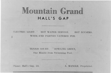 Halls Gap & Grampians Historical Society
Photograph - B/W
Advertisement for Mountain Grand Halls Gap A Mangle was the proprietor Electric Light, Hot water service, Hot dinners, Week-end parties catered for Tennis Court, Bowling Green, one minute from swimming poolAdvertisement for Guest HouseAGFA quality paper made in Germanymedia, advertisements, accommodation, mountain grand -
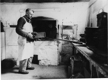 Halls Gap & Grampians Historical Society
Photograph - B/W, C 1950s (?)
Robert Greer, baker, married Ida Warren whose family started the bakery; in 1929. Robert & Ida inherited the Bakery from Ida's father John Warren. for further information see Bridging the Gap p. 56Photo shows Robert Greer, baker standing with a load tin in his hands, inside the bakery. Baking tins & ovens can be seen in the photo.Folio no.48 Negative no.25people, greer, buildings, bakery -
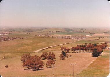 Hume City Civic Collection
Photograph, 1980s
The photograph was taken above Reservoir Road on the lower slopes of Mt. Holden. It is looking south down Wilson's Lane towards some of the early Sunbury developments which grew around the Gap Road area in the early 1980s.A landscape coloured photograph with rounded corners. It is a panoramic view of Sunbury taken from the southern slopes of Mt. Holden. In the foreground there is a small cluster of trees and in the middle distance there is some evidence of housing development. Bald Hill can be seen on the skyline.wilson's lane, mt. holden, bald hill, sunbury, george evans collection -
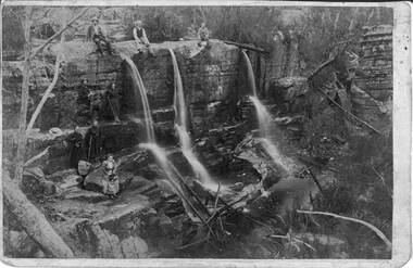 Halls Gap & Grampians Historical Society
Photograph - Sepia, C 1900s
Some of the people in the photo are said to be members of the Balmain family. James and his wife Amy Sophia (nee D' Alton) had three children. Amy died suddenly in 1902 at the age of 37. See p45 Bridging the Gap.Photo shows group of people seated and standing by a waterfall,three men seated on top of waterfall, next level a man and a young woman ( who is holding a hiking stick), top level a man and woman both holding hiking sticks. In front of them seated on a rock is a woman holding a hat. on her lap Waterfall is split into three and they flow over a larger rocky platform.Balmains c1900recreation, bush-walking -
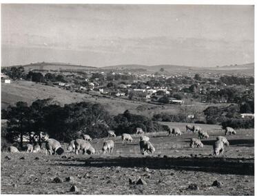 Hume City Civic Collection
Photograph, Early 1970s
The photograph was taken when Sunbury township did not extend far beyond Anderson Road to the west and Powlett Street to the east. The Paynes housing development can be seen scattered across the hillside between Gap Road and Mitchells Lane.A black and white photograph of a panoramic view of Sunbury township looking west and taken from above the Goonawarra Winery. Sheep are grazing on the hilside in the foreground.sunbury township, goonawarra winery, george evans collection -
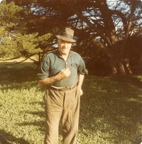 Stawell Historical Society Inc
Photograph, Mr Ernie Tremaine -- Coloured photograph c 1980"s
The photo of Ernie Tremaine (died 16.4.1985) was taken by Alice Devereux. Alice and her sister Dot Sharrock stopped to look at the Treasury memorial on the Halls Gap road. Mr. Tremaine lived nearby and came out to chat with them.Coloured photo of Mr. Erne Tremaine dressed in casual clothes' and hat. c 1980'sstawell -
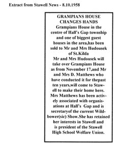 Halls Gap & Grampians Historical Society
Newspaper - Photocopy, C 1958
Grampians House Changes Hands Grampians House in the centre of Hall's Gap township and one of the biggest guest houses in the area has been sold to Mr and Mrs Hudousek of St. Kilda Mr and Mrs Hudousck will take over Grampians House as from November 17, and Mr and Mrs D Matthews who have conducted it for the past ten years will come to Stawell to make their home here. Mrs Matthews has been actively associated with organisations at Hasll's Gap and is secretary of the current Wildbower (sic) Show. She has retained here interests in Stawell and is president of the Stawell High School Welfare Union. Typed extract from Stawell News 8-10-1958media, newspaper articles, guesthouses, grampian house -
 Kiewa Valley Historical Society
Papers - Jim Goonan's Story - Dederang, 1950's
Early settlers came to Dederang from Kergunyah. The main road, Dederang to Tawonga was opened about 1860 - 1864, connecting 'Crosthwaite's Gap' with 'Smith's corner'. Jim Goonan's ancestors selected land between Dederang and Tawonga in the early 1860's.A comprehensive history of the town of Dederang from the 1860's up to the 1950's. Early settlers, infrastructure, businesses, activities including sport and life style are described giving an insight into how the Kiewa Valley developed during this time.26 typed pages of the History of Dederang. Each page consists of paragraphs with a heading.dederang, jim goonan, kiewa valley -
 Halls Gap & Grampians Historical Society
Photograph - B/W, C 1924
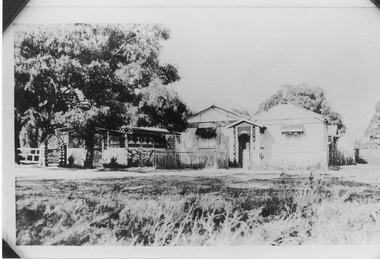
Gus Knight bought 2 blocks on the Henham Estate and built his home at tea rooms Unfortunately the estate failed and so after two years he moved the tea rooms to a new site over Mirranatwa Gap to the Wannon CrossingPhoto shows Knight's Tea Rooms at Henham Estatebuildings, shops, knight -
Tatura Irrigation & Wartime Camps Museum
Booklet, The Graytown Goldrush, 1977
Contains early history of gold rush in Graytown streets and stores, now all gone. Cemetery reamins in bushland. Loose leaflets of invitations (2) to blessing of restored graves, 12.3.1995. Other books by Joyce Hammond : Bridging The Gap, Walls of Wire.Written to record the history of the gold rush days. Kangaroos on the cover. Graytown Cemetery 1869-1947gold, rushworth, books, history, local -
 Hume City Civic Collection
Photograph, early 1990s
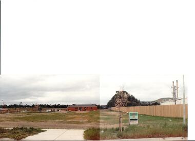
The series of 5 photographs feature different views of the Woodlands housing development which opened up land bounded by Gap and Anderson Roads, Cornish Street and Elizabeth Drive in the early 1990s. It was a large housing development built close to Sunbury township.A view of the northern boundary of the Woodlands housing development in Anderson Road. A paling fence divides the estate from the 'Malley' factory, now 'Storage King' which is on the corner of Cornish Street and Anderson Road. A 'For Sale' sign is in the foreground and a partly built house is in the middle distance.housing developments, anderson road, george evans collection -
 Hume City Civic Collection
Photograph, early 1990s
The series of 5 photographs feature different views of the Woodlands housing development which opened up land bounded by Gap and Anderson Roads, Cornish Street and Elizabeth Drive in the early 1990s. It was a large housing development built close to Sunbury township.A coloured photograph of a new housing development taken in Anderson Road looking west towards Elizabeth Drive and the leisure centre. Some housing construction is in the middle distance.housing developments, anderson road, george evans collection -
 Hume City Civic Collection
Photograph, Aitkens Gap Police Barracks, c1922
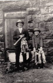
Frank Millett and his nephew Hopper Cahill are the two people standing by the building after spending the day shooting rabbits in 1922. They are standing in front of the Aitkens Gap Police Barracks. In the 1860s the gaol and stables were sold to George Millett and added to the Millett property. The Barracks and the new farm homestead were built by Mick Morrison. The Bald Hill Hotel at Aitkens Gap on the Bendigo Road (Calder Highway) was guilt by George Millett in 1854 and functioned until the gold began to run out after the Victorian Gold Rush of the 1850s. The Millett family continued to farm until 1967. The family also and operated hotels in the local area. A black and white photograph backed onto a white board of a man and a child holding some dead rabbits and standing in front of the doorway of a bluestone building. frank millett, george millett, aitkens gap gaol, hopper cahill -
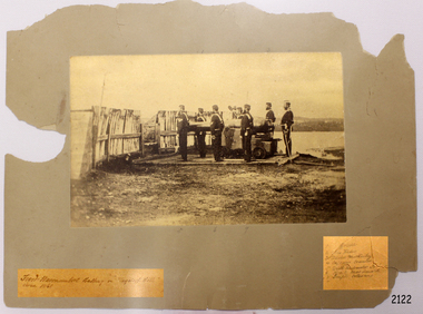 Flagstaff Hill Maritime Museum and Village
Photograph - Military, First Warrnambool Battery on Flagstaff Hill, ca. 1868
There was an active Volunteer Corps in Warrnambool in the 1800s. This photograph shows a group off military men on Flagstaff Hill ready for action. The names are listed on the card, handwritten in pencil: 1. Gorrie 2. Chris Hider 3. David McKinley 4. Captain Cramer 5. Drill Instructor (cannot read name) 6. R.A.C. Macdonald 7. Joseph GladstoneThe militia played a significant role in being prepared to defend the Warrnambool district.Photograph, sepia, mounted on brown card. Depicts the First Warrnambool Battery on Flagstaff Hill. Seven uniformed figures stand beside a cannon mounted on a wooden, waist high carriage. The cannon is aimed between a gap in a timber fence. The lower edge of the card has two labels with handwritten inscriptions; one is the photograph title, the other is a list of seven names written in pencil Photograph is dated ca. 1868. Left hand side: "First Warrnambool Battery on 'Flagstaff Hill'" Right hand side: list of names written in pencil: "1. Gorrie 2. Chris Hider 3. David McKinley 4. Captain Cramer 5. Drill Instructor (cannot read name) 6. R.A.C. Macdonald 7. Joseph Gladstone"flagstaff hill, warrnambool, maritime museum, maritime village, shipwreck coast, great ocean road, militia, volunteer corps, cannon, gun, firearm, first warrnambool battery, warrnambool battery, defence, gorrie, chris hider, david mckinley, captain cramer, drill instructor, r.a.c. macdonald, joseph gladstone