Showing 8256 items
matching watering
-
 Ballarat Heritage Services
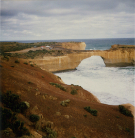
Photograph, London Bridge, Great Ocean Road, 01/1990
London Bridge, pre 1990 was a double-spanning bridge connected to the mainland. The stack was created over hundreds of years, with the weaker layers toward the base being eroded away by wind and water to form the two bridges. The span closer to the shoreline collapsed unexpectedly on 15 January 1990, leaving two visitors, whilst uninjured, stranded on the outer span before being rescued by helicopter. Two coloured photographs of the London Bridge, on the Great Ocean Road. This photo was taken days before the collapse of the geological feature. The photographer walked across the bridge to the warning of her mother "if you go over there and it collapses you will be stuck. After the collapse it was renamed London Arch. london bridge, great ocean road, london bridge, peterborough, london arch, shipwreck coast, 12 apostles -
 Port Fairy Historical Society Museum and Archives
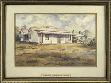
Painting - painting, watercolour, Horse and Jockey Hotel Orford, 01.02.1984
Painted for Mrs Ruby Young whose family owned the hotel at one time - (since burnt down) The hotel was built around 1857 near "Shaw Crossing" when Cowton and Bland selected the site because the bullockies watered and rested their stock on route Belfast and Portland. The name of the hotel came about because the winning post for the horse races was in front of the inn and the jockeys weighed in there.Illustration of a hotel that became the hub of social life in Orford that no longer exists.Watercolour painting of "Horse and Jockey" Hotel Orford. Frame composite wooden gilt embossingChristopher Mathews Ruby Young 1989 50 Whalers Road Victor Harbor S.A. 5211 1/2/84local history, illustrations, watercolours, horse and jockey hotel, ruby young, horseracing -
 Wodonga & District Historical Society Inc
Album - Ringer's River by Des Martin - Plate 34 - Fleeing to New South Wales
Plunging into the deep water O'Day swims with his horse to the colony of New South Wales where he may live as a free man on his property Brightons. However he has already been convicted, in absentia, of evading customs duty. Since the cattle were not impounded this tax could not be calculated, but O'Day is now a wanted man in Victoria with a fine of £1000 on his head.The album and images are significant because they document literature written by a prominent member of the Wodonga community. The presentation of this precis was supported by several significant district families and individuals.Ringer's River Album Coloured photo Plate 34des martin, many a mile, ringer's river, northeast victoria stories -
 Melbourne Tram Museum
Photograph - Black and White - MMTB Uniform - 1920's
Photograph, possibly of a driver wearing an MMTB uniform - 1920s. The reproduction print has been made from a damaged negative or copy print with fingerprint marks and water stain damage. The photo shows the cap (possibly number 3508) with the MMTB logo badge, five button tunic with three leather-trimmed pockets, one top pocket along with a button on the top left side.Yields information about early MMTB Uniforms.Black and white photograph of possibly a driver wearing a MMTB uniform. tramways, mmtb, trams, crews, uniforms, tram drivers -
 Bendigo Historical Society Inc.
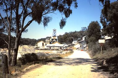
Slide - HORWOOD COLLECTION - WATTLE GULLY, c1965
Wattle Gully, at Chewton was first worked in 1853 albeit initially only to a depth of 10 metres. An exploratory drilling in 1934, that deflected off course, discovered new rich gold seams and by 1937 large amounts of gold were being extracted. The mine closed in 1969 because high water levels and the low price of gold made it unprofitable at the time. It has operated intermittently since then.Horwood Collection - Wattle Gully. Wattle Gully Mine, Chewton. Much of the buildings and other structures still remain. Markings Wattle Gully Chewton. DEC65MKodakmine, gold, walltle gully, horwood collection - wattle gully. wattle gully mine, chewton. much of the buildings and other structures still remain -
 Eltham District Historical Society Inc
Document - Property Binder, 1184 Main Road, Eltham
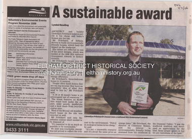
Newspaper article: A sustainable award, Diamond Valley Leader, 1 November2006, Architect and building Llewellyn Pritchard won resource Efficiency Housing Award, finalist in HIA Greensmart Building of the Year Award. House – Environmental Leader (Published: Nillumbik Now and Then / Marguerite Marshall 2008; photographs Alan King with Marguerite Marshall.; p186) In 2006 environmental awareness was mushrooming in the community, which is reflected in the award-winning house at Main Road near Wattletree Road, Eltham. At first sight, the building appears a mix of a classic Eltham mud-brick house and an avant-garde building style. The crown of solar panels stretching along the width of the curved roof, indicates that this is no ordinary house. In fact it signals a new building trend of minimal impact on the environment. Yet it utilises the environment with high technical expertise to achieve comfort and cut running and maintenance costs. In recognition of this, its designer/builder, Conscious Homes, won the 2006 National HIA Greensmart Resource Efficiency Award. For Conscious Homes director, Llewellyn Pritchard, this house reflects a philosophy, strengthened by his connection with Aboriginal culture, through his foster siblings. Pritchard believes the sustainable way indigenous Australians lived and their spiritual connection with land, demonstrates how humanity is part of the ecology. His interest in environmental design stemmed from growing up in bushy Eltham Shire, with its mud-brick tradition. This was followed by studying Architecture at RMIT in the early 1980s, and learning about passive solar design. Pritchard says this house demonstrates that environmental sustainability is not about sacrifice, but about exceptional levels of occupant comfort, savings in running costs and modern fittings and appliances.1 The solar panels on the north roofs are intentionally obvious to make a statement about what the building is doing. But inside the systems are hidden and interactive with conventional services, such as the underground water tank. The house is water and energy self-sufficient and at 12 squares is much smaller than conventional houses, to minimise resources. Yet it accommodates his family of four with three bedrooms, a living/dining and kitchen area and a bathroom/laundry. Importantly the building is designed to last hundreds of years, by being able to be modified as the need arises, such as for commercial use. In this way the structure minimises its environmental impact. The solid double mud-brick walls (which are insulated) include steel beams and supporting frame, allowing the future removal or alteration of any section. The materials are local, recycled and of low toxicity where possible.2 Inside and out, the mud-brick is rendered and sealed with a combination of cement and sand and a mud-based coating in a soft golden hue increases its life. Inside, the golden-brown timber is plantation Mountain Ash and the concrete floors throughout – of local stone aggregate with a clear seal – have a natural looking random stone appearance. The house sustains a stable temperature of around 20 degrees, assisted by the concrete slab floor. The many large double-glazed windows and highlights (windows set high on walls) provide cross-flow ventilation. The north-facing living area maximises heating from the lower winter sun and is cooler in summer, because the sun is higher. Heating comes from a solar hydronic slab system. All appliances and fittings are high efficiency energy or water rated. Appliances in the timber kitchen include a gas stove and a dishwasher, using the building’s own power and water. French doors open from the living area to a deck, concealing the treatment system for all waste water. This is pumped through sub-soil drippers to the indigenous garden beds and no-dig vegetable patch. Below the carport is the 80,000-litre rainwater tank and at the back, the boiler room houses the solar boiler, water tank access, domestic water supply pump, filter gear and hydronic slab heating controls. The solar system is backed up with gas, which is needed to heat water only in winter. Gas used is less than one quarter of that for an average home with ducted heating. Excess power is fed back to the grid and the building uses about one quarter of the mains electricity of an average home. Other local builders have followed Pritchard’s lead in resource efficiency for minimal environmental impact.main road, eltham, businesses, llewellyn pritchard, hia greensmart building of the year award., efficiency housing award, conscious homes australia pty ltd -
 Halls Gap & Grampians Historical Society
Photograph - B/W, C 1931
A major rebuilding project took place. Brothers John & Thomas Morgan with local storekeeper Harold Goodwin Taylor designing and building a grand new Guest House with 22 bedrooms plus the original bungalows. Unheard of at the time the guests bedrooms had hand basins with hot & cold running water. This was achieved by building a weir on Stony Creek and piping the water to a high holding tank at the guest house. The dining room was a grand affair, a 4.5 metre high ceiling with beautiful gold leaf cornices, art deco ceiling and wall lights with feature plaster lights in the form of blue bells, wall to wall carpet and Kentia palms completed the picture. Ladies & gentlemen dressed for dinner, the ladies resplendent in their long evening gowns and jewellery would come down the stairway from the entrance hall to the lounge then the dining room. The tables were beautifully appointed with damask table cloths & fine silverware. The kitchen was well appointed with a huge coal fired range and a donkey for hot water. Milk & cream, bacon & pork, chicken & eggs together with vegetables were all home grown on the property. A large ballroom with a beautiful timber floor was the scene after dinner for many dances and party nights with guests from other establishments and locals joining in for the night. A huge fernery was also a feature of the gardens. During the day tennis parties would be held on the courts, together with horse riding and guided walks were taken out by local guide Gilbert Rogers.Photo of newly built Grampian Houseaccommodation, guesthouses, accommodation, grampian house -
 Eltham District Historical Society Inc
Photograph, Liz Pidgeon, Heritage Excursion; Maroondah Aqueduct, 3 September 2016, 3 September 2016
Heritage Excursion - Maroondah Aqueduct Walk - Saturday 3rd September The Maroondah Aqueduct was once a major link in Melbourne’s water supply system. It was built between 1886 and 1891 to transfer water from the Watts River near Healesville to the Preston Reservoir. It was 66 km in length, made up of 41 km of open channel, 10 km of tunnel through hills and 15 km of pipeline across stream valleys known as inverted siphons. The section of the aqueduct through the Eltham area has been abandoned since the 1980s but the open channel has largely been retained. A recreational path follows the aqueduct reserve. For our excursion on 3rd September we intend to walk along the section of the aqueduct adjacent to Allendale Road. This is a section not visited on previous excursions and includes the transition from open channel to the inverted siphon across the Diamond Creek valley. Apart from the aqueduct itself the main feature of the walk is the extensive views across Eltham North and Diamond Creek. Along the way we will talk about the history of the aqueduct and the area. This easy walk is about 3 km return and will take 2 to 2.5 hours. It will start at 2pm at the junction of Allendale Road with Godber Road and Zig Zag Road North, officially Diamond Creek, but on the northern boundary of Eltham. (Melway ref.12 B10). Newsletter No., 229, August 2016 Abandoned and rusted house base probably purposed to water or feed cattle. Born Digitalmaroondah aqueduct, eltham north, activities, eltham district historical society, heritage excursion, bath, acqueduct trail -
 8th/13th Victorian Mounted Rifles Regimental Collection
Functional object - Boiling vessel
The vessels boiling electrical was used by soldiers of 8/13 Victorian Mounted Rifles when it was equipped with Centurion tanks 1966-71. A boiling vessel fitted to British armoured fighting vehicles that permit the crew to heat water and cook food by drawing power from the vehicle electrical supply. It is often referred to by crewmembers (not entirely in jest) as the most important piece of equipment in a British armoured vehicle. The "Vessel Boiling Electric" or "BV" was an innovation at the very end of World War II, when the Centurion tank was introduced with the device fitted inside the turret. Previously, British tank crews had disembarked when they wanted to "brew-up" (make tea), using a petrol cooker improvised from empty fuel cans[4] called a "Tommy cooker". Use of the BV enabled the crew to stay safely inside the tank and reduced the time taken for breaks. The first version, known as VBE No 1, began to be replaced in the early 1950s by the stainless steel No 2 version. A VBE No 3 had improved electrical sockets and was less prone to leakage. The principal use of the BV is to heat ration pouches or tins; the hot water is then used for making drinks or washing. The BV is cuboid and accommodates four tins; typically matching the crew numbers of an armoured fighting vehicle. Ration tins are supplied without adhesive labels so the surrounding water is not contaminated. A vehicle with a defective BV is declared unfit for purpose. It is common practice for a junior member of a vehicle crew to be unofficially appointed "BV Commander", responsible for making hot drinks for the other soldiers. Example of article which improved efficiency and well-being of tank soldiers.Cilinderical metal vessel with close fitting lid, folding handle and electrical socket on side.military, tank, centurion, meals, boiling -
 Eltham District Historical Society Inc
Photograph - Digital Photograph, Marguerite Marshall, Smith Dam, Karingal Drive, Eltham, 19 September 2006
The dam at the entrance to the Nerreman Gateway in Eltham was built according to an internationally acclaimed theory developed by the builder's father. In 1920, Victorian engineer B.A. Smith was awarded the American Society of Civil Engineers J. James R. Cross Gold Medal for his Technical Paper titled 'Arched Dams'. It was the first time this medal had been awarded outside the United States. The concrete arched dam across the Eltham West Drain was built in 1940 by B.A. Smith's son and engineer, D. B. (Bernie) Smith to water the 24 acre (9.75 ha) hobby farm owned by himself and new wife, Isa Smith. Upon completion of the dam a pump-house was constructed beside the creek but before the water could be pumped up the hill they had to dig a trench and lay 500m of 100mm water main to an elevated holding tank. The Smiths made the pump-house their home for several years until they constructed their home at the top of the hill overlooking Eltham and views extending to Kinglake. Following Bernie's death in 1983, Nerreman Park was subdivided between 1993 and 1995. Gordon Ford designed the landscaping and the pump-house was demolished. Covered under Heritage Overlay, Nillumbik Planning Scheme. Published: Nillumbik Now and Then / Marguerite Marshall 2008; photographs Alan King with Marguerite Marshall.; p137 The dam at the entrance to the Nerreman Gateway in Eltham, was built according to an internationally acclaimed theory developed by the builder’s father. In 1920, Victorian engineer B A Smith was awarded the American Society of Civil Engineers J. James R. Croes Gold Medal, for his Technical Paper titled Arched Dams. It was the first time this medal had been awarded outside America. An international example of the application of Smith’s work can be found in the design of the Hoover Dam on the Colorado River, Nevada, USA. Built between 1930 and 1936, it is recognised by the ASCE as one of ‘America’s Seven Modern Civil Engineering Wonders’.1 The concrete arched dam across the Eltham West Drain was built by B A Smith’s son and engineer, D B (Bernie) Smith. Bernie’s dam followed his father’s theory, having a curvature that takes maximum advantage of concrete’s great strength in compression. The water load is carried into the abutments because of this curvature, which permits a wall thickness of only 225 millimetres thick at its crest, despite the dam’s capacity of more than 4.5 megalitres. The Eltham dam was designed to water the 24 acre (9.75 ha) hobby farm belonging to newly married couple Bernie and Isa Smith. Bernie, from Armadale, and Isa, from a farm at Tyntynder near Swan Hill, were attracted to the hilly topography and the creek running through the property. It extended from Ryans Road, Eltham, to Karingal Drive, Montmorency and was adjacent to Meruka Park. The Smiths named it Nerreman Park using the Aboriginal word Nerreman meaning ‘River Bend’ as their creek had a pronounced bend.2 In 1940 the first thing Bernie did was to build a dam, and with Isa’s help, a pump-house, to secure a water supply for their cattle, pigs, chickens, orchard and vegetable gardens. It was also available for the fire-plugs, which they placed all over the property in case of bushfire. The couple built the pump-house beside the creek and installed a Tange three-plunger pump, which had originally supplied the City of Wodonga with water. But before the Smiths could pump water up the hill from the dam they had to dig a trench and lay about 550 yards (500m) of a four-inch (100mm) water main up to an elevated holding tank. The trench was dug with a single furrow plough drawn by an old draught horse. Living in rough conditions did not deter the Smiths, who made the pump-house their home, where they still lived when their first child was born in 1944. They later built their home at the top of their property overlooking Eltham, with magnificent views to Kinglake, the Dandenong Ranges and Melbourne. From 1946 it took them almost 20 years to complete the 36-square house with its 12-foot (3.6m) high ceilings. Material for the concrete roof and walls faced with sandstone, was ripped out of the ground on their property by plough pulled by tandem Clydesdale horses. Isa was a strong woman – two days before their second child was born – she set three huge sandstone boulders in place in the bottom wall of the garage. She also mixed all the cement for the house. A collapsed kitchen wall did not discourage her from rebuilding it in a week, while her husband was away working in the country. She later recalled: ‘We stood back to admire this beautiful wall we’d built and while we were looking at it, it came tumbling down’.3 Following Bernie’s death in 1983, Nerreman Park was subdivided, between 1993 and 1995. Local Gordon Ford designed the landscaping and the pump-house was pulled down. But the dam remains as a reminder of exceptional engineering4 – and of a remarkable couple.This collection of almost 130 photos about places and people within the Shire of Nillumbik, an urban and rural municipality in Melbourne's north, contributes to an understanding of the history of the Shire. Published in 2008 immediately prior to the Black Saturday bushfires of February 7, 2009, it documents sites that were impacted, and in some cases destroyed by the fires. It includes photographs taken especially for the publication, creating a unique time capsule representing the Shire in the early 21st century. It remains the most recent comprehenesive publication devoted to the Shire's history connecting local residents to the past. nillumbik now and then (marshall-king) collection, eltham, karingal drive, smiths dam, bernie smith, gordon ford, isa smith, nerreman gateway, nerreman park estate, dams -
 Clunes Museum
Photograph
COPY OF PHOTOGRAPH OF FLOOD ON CRESWICK CREEK AT GOVERNMENT BRIDGE12/9/1909 FROM CLUNES TALBOT RD. MOTHER WRITING TO AMY. CLUNES JUBILEE BRIDGE DURING THE SEVERE FLOOD, WHEN AT ITS HIGHEST MARK. IT REMINDED ME OF SEA WAVES. THE WATER WAS AT OUR FEET AS WE STOOD WATCHING IT IN MRS BARKELL'S COW YARD. MRS BARKELL AND MARY WHITE (THE WRITER) TOOK IT IN TURNS TO COOK DINNER AND WATCH THE FLOODflood 1909, mrs a white, flood creswick creek -
![Township of Lorne, and Loutitt Bay / [by] Nicholas Caire, circa 1876](/media/collectors/550653872162f11fb04854aa/items/5783458ad0cdd1176c6f0c78/item-media/578345eed0cdd1176c6f852b/item-fit-380x285.jpg) Kew Historical Society Inc
Kew Historical Society IncPhotograph, Anglo-Australasian Photographic Company, Township of Lorne, and Loutitt Bay, c. 1876
Nicholas Caire was born on Guernsey in the Channel Islands in 1837. He arrived in Adelaide with his parents in about 1860. In 1867, following photographic journeys in Gippsland, he opened a studio in Adelaide. From 1870 to 1876 he lived and worked in Talbot in Central Victoria. In 1876 he purchased T. F. Chuck's studios in the Royal Arcade Melbourne. In 1885, following the introduction of dry plate photography, he began a series of landscape series, which were commercially successful. As a photographer, he travelled extensively through Victoria, photographing places few of his contemporaries had previously seen. He died in 1918. Reference: Jack Cato, 'Caire, Nicholas John (1837–1918)', Australian Dictionary of Biography.An original, rare photograph from the series 'Views of Victoria: General Series' by the photographer, Nicholas Caire (1837-1918). The 60 photographs that comprise the series were issued c. 1876 and reinforced a neo-Romantic view of the Australian landscape to which a growing nationalist movement would respond. Nicholas Caire was active as a photographer in Australia from 1858 until his death in 1918. His vision of the Australian bush and pioneer life had a counterpart in the works of Henry Lawson and other nationalist poets, authors and painters.‘Township of Lorne, and Loutitt Bay’ : Views of Victoria (General Series) No.60 : Albumen silver photograph | Photo on card with Title and Description on reverse | Mounted 24 x 30 cm; Photo 12 x 17 cm.On Reverse: ‘Loutitt Bay is fast becoming one of the most fashionable Watering-places in Victoria, partly from its easy access by Rail, combined with the magnificent scenery to be found in the Cape Otway Ranges, and the very moderate charges of the houses of accommodation. The large house near the foreground is that of Mr. Mountjoy, which is a Restaurant. Duncan’s Hotel can be seen in the distance, on the brow of the hill.’nicholas caire (1837-1918), lorne (vic), duncan's hotel, loutitt bay, landscape photography - victoria -
 Warrnambool and District Historical Society Inc.
Domestic object - Cooking Bowl, Quick Cooker, Early 20th century
This item is an early type of cooker and would have been used to cook meat and puddings in the first two or three decades of the 20th century. It has no known local provenance but may have been a display item from the old Warrnambool Museum which was established in 1883 and was dismantled in the 1960s. This item, although incomplete, is of interest as a cooking bowl from the past and is retained for display purposes. This is a circular-shaped white china bowl. The base has a hollow tube protruding up through the centre of the bowl. There is printing on the outside of the bowl and on the top inside section. The lid of the bowl is missing. The ‘Quick Cooker’ Patent No 12161/11 Gold Medal London 1911 Excellent for stews of all kind Meat can be kept hot for hours without over-cooking or getting dry Grimwade’s Patent Nos 12835/09, 15043/09 Do not fill above this line – The pudding then has room to expand Water in saucepan should also be about this level ----- vintage culinary items, history of warrnambool, quick cooker -
 Kiewa Valley Historical Society
5 small black and white photos of Clover Dam and Power Station, c1948
The construction of Clover Power Station was commenced in October 1942 and the power station building was completed in May, 1943. The first machine was placed in service August, 1944 and the second machine in May, 1945. The water discharges directly into Clover Dam and re-used in West Kiewa Station. Clover Dam - stripping of foundation area commenced in January 1948 but the final concrete pour was not until 14th August, 1954.Pictorial history of the early construction undertaken in the building of the Kiewa Hydro Electric Scheme. Clover power station (No. 3 Development) was the first power station to be built .5 small black and white photographsPhoto No. 1 - handwritten in ink on back ' No. 3 Power Station Clover Flat Nov. 1948 Photo No. 2 - handwritten in ink on back 'No. 3 Power Station Clover Flat Nov. 1948 Photo No. 3- handwritten in ink 'Clover Flat looking towards work area of Clover Dam. Taken near #3 PS. Nov. 1948 Photo No 4 - Handwritten in ink 'Preparation for wall of Clover Dam Dec. 1948 Photo No.5 - handwritten in ink 'Preparation for wall o f Clover Dam Dec. 1948. Photo Nos. 1,2 3, on the back have circular stamp with 'Print by Willson White Albury'. In pencil is the number '78'. Photo Nos. 4, 5, have written on the back in pencil, number '14'. construction, clover power station, clover dam, -
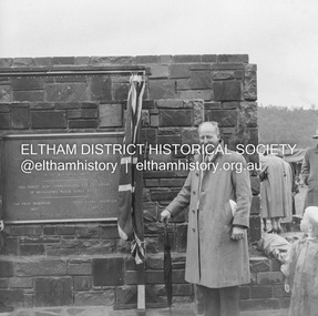 Eltham District Historical Society Inc
Negative - Photograph, J.A. McDonald, Upper Yarra Dam, 26 Nov. 1957
Sir Dallas Brooks following the formal opening of the Upper Yarra Reservoir, 26 November 1957 Upper Yarra Reservoir Opened by His Excellency The Governor of Victoria General Sir Dallas Brooks K.C.B.., K.C.M.G., K.C.V.O., D.S.O., K.St.J. On 26th November, 1957 This tablet also commemortyaes the centenary Of Melbourne's water supply system Yan Yean Reservoir 1857 Upper Yarra Reservoir 1957Record of various Shire of Eltham infrastructure works undertaken during the period of 1952-1962 involving bridge and road reconstruction projects, sometimes with Eltham Shire Council Project Reference numbers quoted. It was during this period that a number of significant improvements were made to roads and new bridges constructed within the shire that remain in place as of present day (2022). In many situations, the photos provide a tangible visible record of infrastructure that existed throughout the early days of the Shire. The album was put together by or under the direction of the Shire Engineer, J.A. McDonald.infrastructure, shire of eltham, 1957-11-26, opening ceremony, plaques, sir dallas brooks, upper yarra dam, upper yarra reservoir -
 Phillip Island and District Historical Society Inc.
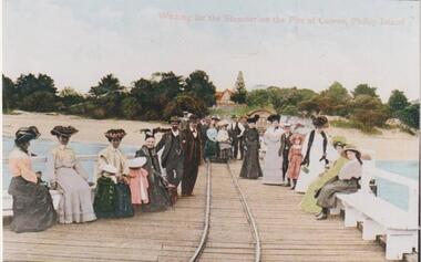
Photograph, Cowes Pier, Phillip Island, 1920
A group of twenty-two people seated and standing on the Cowes Jetty, which was built in 1870. Trolleys on iron rail were used to convey goods along the Jetty. Slightly obscured by people is the Jetty Shed, built in 1870 and now classified by National Trust. Beyond water and beach are trees and shrubs. One gap mid centre depicting The Isle of Wight Hotel - licensed in 1870 - and a large Norfolk Pine.Group waiting for ferry "Genista" on the Cowes Pier.Waiting for the Steamer on the Pier at Cowes, Phillip Islandlocal history, photographs, jetties, cowes, phillip island, colour tinted from black & white photograph, mary robb -
 Halls Gap & Grampians Historical Society
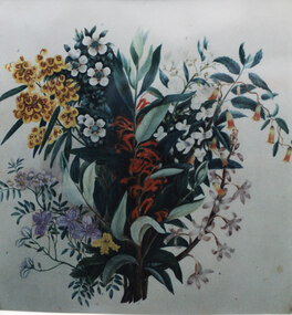
Photograph - Coloured, C 1886
This is a photo of one of a series of wildflower paintings by Henrietta D'Alton. This is one of twelve separate original wildflower paintings mounted within one large frame (this one is the larger centre painting). Beneath the frame in its current (2010) location in the Halls Gap Hall is a plaque which reads "Henrietta D'Alton (1836-1922). This collection of wildflower water-colours won an award at the Colonial & Indian Exhibition of 1886 in London".This is a photo of a painting of a spray of flowers and leaves. There are red flowers in the centre; yellow/red "pea" flowers and white flowers on the upper left, with white, purple and one small spray of yellow flowers beneath them and white flowers and green/red "bells" on the upper right with white flowers beneath them.painting, floral -
 Eltham District Historical Society Inc
Photograph, Floodwaters, Diamond Creek, Eltham, 1934
The Diamond Creek in flood near the Main Road bridge at Eltham, Victoria. The Yarra also was in flood. In early December 1934 the "Greatest flood in the history of the Yarra" occured, according to The Argus newspaper. Bridges and houses were swept away with hundreds of people left homeless across the state. The historic 1934 flood of the Diamond Creek and Yarra River set the criteria for future planning with respect to flood water rise.This photo forms part of a collection of photographs gathered by the Shire of Eltham for their centenary project book, "Pioneers and Painters: 100 years of the Shire of Eltham" by Alan Marshall (1971). The collection of over 500 images is held in partnership between Eltham District Historical Society and Yarra Plenty Regional Library (Eltham Library) and is now formally known as 'The Shire of Eltham Pioneers Photograph Collection.' It is significant in being the first community sourced collection representing the places and people of the Shire's first one hundred years.Digital image 4 x 5 inch B&W Neg (2 frames on one neg) 9 x 15.5 cm B&W printflooding, eltham, shire of eltham pioneers photograph collection, sepp, diamond creek (river), floods, 1934 flood, diamond creek -
 Orbost & District Historical Society
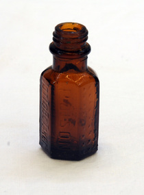
bottle, first half 20th century
This bottle contained Condy's crystals. Condy's Crystals (potassium permanganate) was a popular domestic item for decades, its crystals usually being dissolved in water to make a purple solution for antiseptic and disinfectant purposes. It was also used for snake bite, with standard first aid texts advising that a snake bite should be cut with a knife or razor, the venom sucked out and Condy's Crystals applied to the site. (ref. Powerhouse Museum) A small rectangular four-sided brown bottle. The neck has a screw thread.On sides - POISON NOT TO BE TAKEN On bottom - F1090 Mmedical health bottle condy's-crystals -
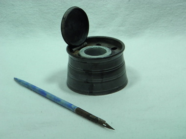 Blacksmith's Cottage and Forge
Ink-well, ceramic insert, steel-nib pen
This ink-well was used in the Bacchus Marsh Court House, possibly for book-keeping and/or for court records. This type of ink-well and pen were in use everywhere in schools, businesses, courts, etc before the invention of the type-writer and the ball-point pen. Clerks were usually male and a good copperplate hand-writing was admired. Ink was often mixed by hand used a powdered ink mixed with water.Of local significance in the history of the town of Bacchus Marsh.Round pewter ink-well, with hinged lid and ceramic insert. Five round holes pierced in inner rim of metal to hold pens. Two ribbed bands around exterior of pot. Two bands indented around top of lid. Insert designed to hold ink. Pen with marbled blue handle, metal nib holder and metal nib.Indecipherable imprint on bottom of pot, possibly machine markings. Illegible written marks on side of pewter pot. Ceramic insert marked on side and bottom by red and black ink.ink, ink well, hand writing, record keeping, pens, nibs, clerical work, court records -
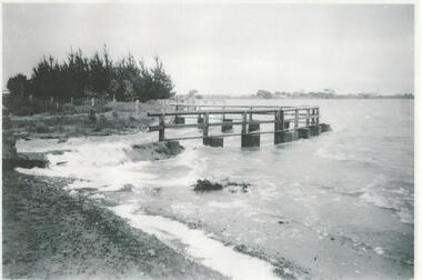 Lake Bolac & District Historical Society
Black and white photograph, Lake Bolac Overflow, 1956
The outlet for the overflow was originally cut in 1926 and concreted over in 1928. This photo shows flooding into Salt Creek in 1956 and looks towards the west and Rockbank. Boards were added to raise the water level of the lake. These were put in annually, below the walkway depicted, until in 1966 the level of the concrete weir was raised. Consequently the lake did not flush through as readily and it gradually silted up and the lake became shallower.lake bolac, overflow, 1926, 1928, flood, 1966, salt creek, rockbank -
Clunes Museum
Tool - GOLD CRADLE & PANNING DISH, JAMES ESMOND, CIRCA 1850
USED TO OBTAIN ALLUVIAL GOLD THE DESIGN OF THIS EQUIPMENT IS MOSTLY BASED ON THE PRINCIPLE OF THE WAY HEAVY MINERALS ARE CONCENTRATED IN ALLUVIAL DEPOSITS. THE PROSPECTING DISH IS USED WHEN WORKING WITH SMALL AMOUNTS OF STONES & CLAY WHILE BIGGER JOBS THE CRADLE OR BANJO IS MORE EFFICIENT. THE GAUZE OF MESH IN THE SIEVE IS VARIABLE. THE CRADLE OR BANJO IS USUALLY SET UP AT RIGHT ANGLES TO A SHALLOW CREEK OR WATERHOLE WITH THE OPEN ENDS TOWARDS THE WATER.1 WOODEN CONSTRUCTION MADE BY HAND WITH GAUZE FILTER IN UPPER SECTION TO SEPARATE QUARTZ ROCKS, SAND AND SOIL. A HANDLE ON BOX LIKE CONSTRUCTION IS USED TO ROCK THE CRADLE WHICH IS MOUNTED WITH ITS ROCKERS RESTING ON WOODEN BEARERS. .2 PANlocal history, mining equipment, mining -
 Stawell Historical Society Inc
Photograph, Stawell Water Supply -- Grit Chamber Straining Station -- Coloured
Colour photograph of a brick building Grit Chamber, beside tunnel entrance on Mt William range. Part of Stawell water supply system. Building has 2 windows and one door. At the door a man is standing with one arm leaning near the door holding a hat. Roof is iron. Background shows trees. Man is Geoff Sudholtz. Building burnt down c2006 with only foundations left.buildings, water supply -
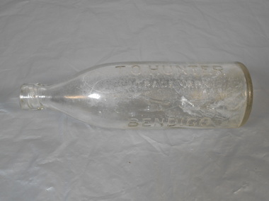 Bendigo Historical Society Inc.
Domestic object - Bottle
Thomas Oliver Hunter was born in1867 and died in Bendigo in 1941. Advertisements show the following:- 1891- manufacturer of aerated water and cordial. 1893 had a stock of ales and stout 1908 - joined with his brother Frederick and became Hunter Bros. 1912 - Brewer 1915 - Combined with Steward Bros. of Eaglehawk and the company became Steward and Hunter Pty Ltd. The site of manufacturing was the Kent Brewery in Bridge St., BendigoBottle Glass with marking on one side and down the bottom T.O.HUNTER TRADEMARK (EMBOSSED GREYHOUND) BENDIGO. THIS BOTTLE IS THE PROPERTY OF T.O. HUNTER BENDIGO AND CANNOT BE LEGALLY USED BY OTHERSbottle, glass -
Vision Australia
Audio - Sound recording, Vision Australia, Around Vision Australia: Episode 6
Covering issues and news about Vision Australia and the opportunities it provides for clients, volunteers and staff. Host: Stephen Jolley with guest interviews by Valerie Thomas. Robyn speaks with Cath McKay at educational programs at the College, Valerie chats with Board Member Kevin Murfitt on winning the title of World Champion Blind Water-skier, and Robyn concludes Stephanie Kain and the Client Satisfaction Survey and the Christmas card catalogue.1 digital sound file in WAV formatradio shows, vision australia, valerie thomas, robyn mckenzie, cath mckay, kevin murfitt, stephanie kain -
 City of Kingston
Photograph - Black and white, c. 1958
This photograph depicts flooding of Ozone Avenue in Beaumaris, located off Balcombe Road. Roads in the Beaumaris area lacked sufficient drains to clear surface water. In many cases streets were unsealed and without footpaths and some were dirt tracks. Gutters and road surfaces were made of clay and in the wetter months of winter, unsealed roads and tracks became impossible quagmires that were unnavigable for vehicles and pedestrians. In the first decade after World War II there was rapid expansion in construction of new houses in the suburb of Beaumaris. Utilities and infrastructure to support the growth of housing was inadequate and not provided for prior to the development of the area. Without rudimentary drainage, flooding was frequent. Storm water runoff, domestic sullage and septic tank overflow would form large pools and families were sometimes marooned within their homes. The frequent flooding caused isolation and hardship and residents endured difficulties with accessibility to facilities. These disadvantages had the potential to cause social issues for the new residents.Black and white photograph of flooding in Ozone Avenue, Beaumaris. The image shows floodwaters with boggy and rough terrain on an unsealed road with housing in the distance.Handwritten in blue ink: 2124 circled Handwritten in red ink: 80% Handwritten in blue ink on yellow Post-It note: Chap 6. underlined, 2194 Ozone Ave Beaumaris 1958beaumaris, ozone avenue, balcombe road, flooding, roads, infrastructure -
 Melbourne Tram Museum
Document, Rules for Horse Car Drivers
Copy of a document from an original source, handwritten and partly typed. Details the 78 Rules that applied to the Melbourne Tramway and Omnibus Company horse tram drivers and their operations. Gives rules for their personal behaviour, duties, watering of the horses, passing of other horse-drawn trams, walking horses around curves, operations, management of passengers, use and care of cash boxes, accidents, fares, tickets, and general work.Yields information about the rules that Melbourne horse tram drivers operated by.Set of two blue foolscap handwritten or typed sheets consisting of six sheets each (Rules 1 to 78) titled Rules for Horse Car Drivers and special notice for drivers.tramways, trams, rules, mtoco, horse trams, horse cars, drivers -
 Melbourne Tram Museum
Ephemera - Real estate sale, Forrester & Co, "Talbot Estate" Balaclava, Nov. 1917
Pamphlet advertising the sale of land at the Talbot Estate on the south side of Balaclava Road, Balaclava on Saturday 24 Nov. 1917. Promotes the train service from Flinders St, tram service, St Kilda Esplanade, tram services including a photo of PMTT No. 61 at the intersection of Kooyong Road and Balaclava Road. Gives details of the tram fares, agents, solicitors, terms of sale, roads and water supplies.Demonstrates the style of land sale pamphlet including the availability of tram services to prospective purchasers.Pamphlet - folded - printed in two colours of cream coloured paper with photographs.sale of land, trams, balaclava, balaclava road, real estate, talbot estate -
 National Wool Museum
Photograph - Transporting Wool, 1960s
One of fifty one photographs originally in a photo album found in the National Wool Museum’s office. The album was water damaged and the images were removed for conservation. The images follow the process of wool. Beginning in a sheep paddock and finishing as a folded fabric. It includes all the steps in between in this process, including shearing, transporting, selling, washing and the many different steps in the process of turning a single thread of wool into fabric.Black and white image showing a man standing in front of a truck loaded with wool bales. The bales are being transported from Boorowa to Sydney.AUSTRALIAN NATIONAL PUBLICITY / ASSOCIATION / FLINDERS STREET RAILWAY BUILDING, / MELBOURNE AUSTRALIA / W40. Seventy bales of Wool going by motor vehicle from Boorowa to / Sydney.wool industry, working life, women, boonoke station, farming, sheep farming, agriculture, sheep stations, transport, wool processing, shearing, textile industry, wool -
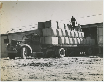 National Wool Museum
Photograph - Loading Wool Bales, 1960s
One of fifty one photographs originally in a photo album found in the National Wool Museum’s office. The album was water damaged and the images were removed for conservation. The images follow the process of wool. Beginning in a sheep paddock and finishing as a folded fabric. It includes all the steps in between in this process, including shearing, transporting, selling, washing and the many different steps in the process of turning a single thread of wool into fabric.Black and white image showing two men loading wool bales onto a motor transport vehicle.AUSTRALIAN NATIONAL PUBLICITY / ASSOCIATION / FLINDERS STREET RAILWAY BUILDING, / MELBOURNE AUSTRALIA / W68 / W68. Loading wool bales on to / a motor transport.wool industry, working life, women, boonoke station, farming, sheep farming, agriculture, sheep stations, transport, wool processing, shearing, textile industry, wool