Showing 4551 items matching "historical maps"
-
 Friends of Ballarat Botanical Gardens History Group
Work on paper - Wellingtonia, Autumn 2014, Tree of the Month, Autumn, 2014
This page gives historical information of Gondwana found in the Ballarat Botanical Gardens.These families of plants are confined originally to Australasia and South America and at least 15 are to be found in the Ballarat Botanical Gardensp.4 of the Friends of Ballarat Botanical Gardens periodical, The Wellingtonia. This is a printed page with 2 maps of the Globe, right-hand side of the page.None.john garner, doctor, doctor john garner, tree of the month, gondwana trees in the ballarat botanical gardens, friends of ballarat botanical gardens, history group, conifers, bunya bunya pine, monkey puzzle, wellingtonia, araucaria, john garner collection, gardens, ballarat -
 Falls Creek Historical Society
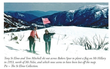
Photograph - Tom Mitchell and Toni St. Elmo plant flag at Mt. Hillary
Tom Mitchell was a strong supporter of trans-Tasman ski competitions and in the early 1950s visits between local clubs became common. In 1953 a team from New Zealand visited Falls Creek for the first time. This was only a few months after Edmund Hillary and Nepalese Sherpa Tenzig Norgay became the first climbers confirmed to have reached the summit of Mount Everest. Toni St. Elmo, supported by Tom Mitchell proposed that a peak on the Bogong High Plains northwest of Mt. Nelse should be named Mt. Hillary in honour of the New Zealander's success. He also suggested a ceremony should be held during the visit of members of the New Zealand Ski team to Australia in September 1953. This image from the St. Elimo Collection held by the Falls Creek Historical Society, represents the planting of a New Zealand flag on the mountain during the ceremony.This image is significant because it is part of the St. Elmo Collection which documents early pioneers of Falls Creek and their outstanding contribution to skiing in Australia.A coloured image of two skiers carrying a New Zealand flag across the High Plains.Beneath the image: Tony St Elmo and Tom Mitchell ski out across Bakers Spur to plant a flag on Mt Hillary in 1953, north of Mt Nelse, and which now seems to have been lost off the map. Pic - The St Elmo Collection.tom mitchell, st. elmo collection, toni st. elmo, sir edmund hillary -
 Bacchus Marsh & District Historical Society
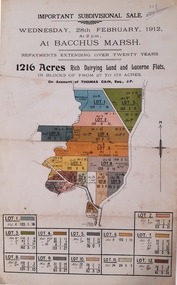
Map, Important Subdivisional Sale at Bacchus Marsh, Wednesday 28 February, 1912, 1912
In the later 19th century and early 20th centuries Thomas Cain was a major farmer in the Bacchus Marsh district and a significant participant in community life and affairs. The sale of some of his most significant properties towards the end of his life generated wide interest in Bacchus Marsh and beyond.Paper. 33cm x 21cmnon-fictionIn the later 19th century and early 20th centuries Thomas Cain was a major farmer in the Bacchus Marsh district and a significant participant in community life and affairs. The sale of some of his most significant properties towards the end of his life generated wide interest in Bacchus Marsh and beyond.land sales, thomas cain, landholders -
 Bacchus Marsh & District Historical Society
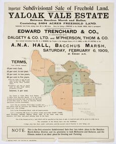
Map, Edward Trenchard & Co, Important Subdivisional Sale of Freehold Land Yaloak Vale Estate
A land sales map and advertisementLand sales advertising poster with map indicating specific lots of land for sale.A land sales map and advertisementimportant subdivisional sale of freehold land yaloak vale estate, land sales -
 Bacchus Marsh & District Historical Society
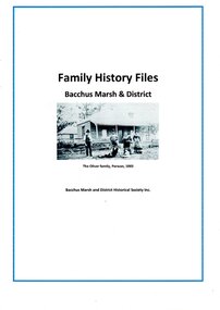
Document, Family History Files, Bacchus Marsh & District
Family History files relating to families and individuals from the township of Bacchus Marsh and its surrounding district. Files may contain family trees, replies to research inquiries, obituaries, biographical material, photocopies of published and unpublished material from books, newspapers, magazines, pamphlets, maps, archival sources and personal papers. Material may also include copies data from births, marriages, deaths, funeral, cemeteries and other genealogical registers and indexes. of Other material includes printouts of website pages, and photocopies or printouts of images. Arranged in A-Z sequence by family surname.Paper documents in ring and lever arch foldersFamily History files relating to families and individuals from the township of Bacchus Marsh and its surrounding district. Files may contain family trees, replies to research inquiries, obituaries, biographical material, photocopies of published and unpublished material from books, newspapers, magazines, pamphlets, maps, archival sources and personal papers. Material may also include copies data from births, marriages, deaths, funeral, cemeteries and other genealogical registers and indexes. of Other material includes printouts of website pages, and photocopies or printouts of images. Arranged in A-Z sequence by family surname.obituaries, funeral notices, death notices, births, marriages, cemetery records -
 Bacchus Marsh & District Historical Society
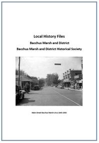
Local History Files Bacchus Marsh and District, 1969- to present
Local history subject files relating to the township of Bacchus Marsh and its surrounding district. Files may contain replies to research inquiries, photocopies of published and unpublished material from books, newspapers, magazines, pamphlets, maps, archival sources and personal papers.. Other material includes printouts of website pages, and photocopies or printouts of images. Material compiled by members of Bacchus Marsh and District Historical Society.Paper files in ring folders and lever arch folders. Arranged in A-Z sequence of topics.non-fictionLocal history subject files relating to the township of Bacchus Marsh and its surrounding district. Files may contain replies to research inquiries, photocopies of published and unpublished material from books, newspapers, magazines, pamphlets, maps, archival sources and personal papers.. Other material includes printouts of website pages, and photocopies or printouts of images. Material compiled by members of Bacchus Marsh and District Historical Society.local history, bacchus marsh -
 Bacchus Marsh & District Historical Society
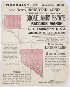
Map - Land Sales Plan, Broadlands Estate, Bacchus Marsh, 1916
This land sales map was produced by real estate agents for an auction of part of a property near Bacchus Marsh known as the Broadlands Estate. 132 acres of irrigated land in 11 separate lots was to be auctioned on the 8th of June 1916. On the 27 May 1916, nine of the 11 eleven lots were withdrawn from sale. The reason stated was due to "road and severance difficulties", according to a notice in the Bacchus Marsh Express newspaper on 27 May, 1916, page.2. When the sale took place on 8th June the two lots were passed in but the local newspaper reported they were expected to be sold privately, see Express, 17 June, 1916, page. 2. The Broadlands Estate was owned by the Miller family whose father Henry Miller, 1809-1888, was a politician and an immensely wealthy financier in Victoria.A typical example of a land sale map of this era. The Broadlands Estate was just over 2,000 acres at its its peak size and was a significant holding of land in the Bacchus Marsh district. Paper printed land sales mapbroadlands estate bacchus marsh, land sales bacchus marsh, farms bacchus marsh, henry miller 1809-1888 -
 Bacchus Marsh & District Historical Society
Map, Bacchus Marsh Township and Nearby Districts Maps Volume
This volume of maps is believed to have been compiled by staff at the Shire of Bacchus Marsh and was presumably used to inform and assist Shire staff and Councillors in the carriage of their duties.This collection of maps are significant due to their rarity as many of them are unique maps made for local purposes in the Bacchus Marsh region. They are also of strong research value containing a wide variety of information including landholders, land sales, infrastructure, such as roads, bridges, public, commercial and private buildings, houses, land use, and geographic features over multiple decades from the late nineteen century into the middle part of the twentieth century.One bound volume of maps comprising cadastral maps, (indicating property owners and land boundaries), land plans and real estate auction plans and advertising material, and other maps indicating major infrastructure like proposed roads and irrigation areas. Most of the maps and plans are of Bacchus Marsh and nearby areas but some maps are of nearby towns such as Melton, Ballan and Blackwood. The volume comprises 52 pages. Most pages have a single map or plan pasted onto it but some contain 2 or 3 different maps. There are 81 maps in total. Map 1 Liquidators Sale 1896. Map 2. Woodside Estate Sale 1913. maps, maps bacchus marsh, maps bacchus marsh region -
 Bacchus Marsh & District Historical Society
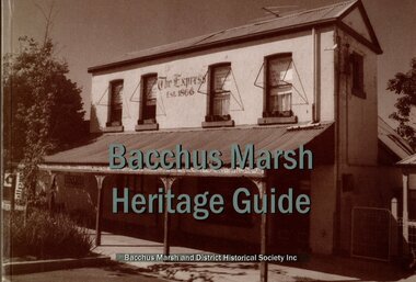
Book, Bacchus Marsh Heritage Guide
Publication details: Bacchus Marsh Heritage Guide, 2nd Rev Ed. Published by Bacchus Marsh & District Historical Society, Bacchus Marsh, Vic, 2003. A guide book to heritage places and historical buildings in the town and surrounding district of Bacchus Marsh. Photos and maps are included to identify each place or building. Each site includes a description of its main features and historical or cultural significance. Places of natural heritage significance are included. A previous less extensive edition was published in 1997.Printed book. 160 pages. BMDHS Location: AR/SU4non-fictionPublication details: Bacchus Marsh Heritage Guide, 2nd Rev Ed. Published by Bacchus Marsh & District Historical Society, Bacchus Marsh, Vic, 2003. A guide book to heritage places and historical buildings in the town and surrounding district of Bacchus Marsh. Photos and maps are included to identify each place or building. Each site includes a description of its main features and historical or cultural significance. Places of natural heritage significance are included. A previous less extensive edition was published in 1997.historic buildings bacchus marsh, historic sites bacchus marsh, bmdhs publication -
 Bacchus Marsh & District Historical Society
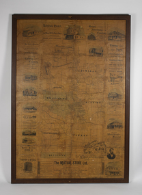
Map, The Unique Advertising Combine, The Unique Combine's New Map of the Shire of Bacchus Marsh, 1890
This map was one of a number of similar maps produced for advertising purposes by a company called, 'The Unique Advertising Combine'. The company was located in Melbourne on Queens Walk. A brief item in the Bacchus Marsh Express newspaper on 29 March 1890 , page 2, indicated that subscribers to the Bacchus Marsh Express could obtain a copy of this map in the next issue of that newspaper. On the map is the detail that it was compiled by W.H. Bonney from official records supplied by D. A. Little, hire Secretary, (of Bacchus Marsh Shire).This map with its accompanying illustrations of local businesses and shops in Bacchus Marsh is an important documentary and visual snapshot of the town and district of Bacchus Marsh in the later part of the nineteenth century. The illustrations for some of the local businesses are the only known visual record of those particular buildings. The map is a rare surviving example of the material produced by The Unique Advertising Combine. Another similar example for the Shire of Mornington is held by the State Library of Victoria,A map of the Shire of Bacchus Marsh produced in March 1890. The map is mounted on a board and enclosed within a timber frame. The map includes an inset detail section showing the central part of the township of Bacchus Marsh including the main shopping and business streets. Land holdings with the first European land holders names indicated are included on the map. Rivers, creeks, major roads and the railway line are also shown on the map. Around the edges of the map are illustrated advertisements mostly for Bacchus Marsh businesses but which also includes some businesses located in Melbourne. maps bacchus marsh shire, shops bacchus marsh -
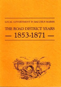 Bacchus Marsh & District Historical Society
Book, John Lloyd, The Road District Years, 1853-1871: Local Government in Bacchus Marsh
This work describes the early evolution and history of local government in the Bacchus Marsh area. Local government bodies in Victoria and in other places had their origins in committees and local boards which were established to regulate over pressing local issues, raise revenue, and expend it in a limited range of social and economic ways. The early areas of responsibility were dominated by the need for local roads and this book primarily looks at this period of local government history in the Bacchus Marsh area. Overtime the range of areas local government bodies took responsibility for expanded and this work begins to trace this transformation in its earliest stages. It is a fascinating and detailed account of the early history of local government in Bacchus Marsh containing many amusing anecdotes among the wealth of administrative historical data. The author who was at one time an employee of the Shire of Bacchus Marsh has drawn directly from the early local records such as minutes of meetings, records of expenditure, newspaper reports and notices in the Victoria Government Gazette.Soft cover foolscap size book. 128 pages with b & w illustrations, maps and plans. No publisher is indicated in the work but it is likely to have been privately published by the author John Lloyd. Year and place of publication is 1986, Bacchus Marsh, Victoria.non-fictionThis work describes the early evolution and history of local government in the Bacchus Marsh area. Local government bodies in Victoria and in other places had their origins in committees and local boards which were established to regulate over pressing local issues, raise revenue, and expend it in a limited range of social and economic ways. The early areas of responsibility were dominated by the need for local roads and this book primarily looks at this period of local government history in the Bacchus Marsh area. Overtime the range of areas local government bodies took responsibility for expanded and this work begins to trace this transformation in its earliest stages. It is a fascinating and detailed account of the early history of local government in Bacchus Marsh containing many amusing anecdotes among the wealth of administrative historical data. The author who was at one time an employee of the Shire of Bacchus Marsh has drawn directly from the early local records such as minutes of meetings, records of expenditure, newspaper reports and notices in the Victoria Government Gazette.bacchus marsh shire council, local government bacchus marsh history -
 Bacchus Marsh & District Historical Society
Map, Lerderderg District Proposed Irrigation and Water Supply Trust (B) Plan Showing Proposed Works
The 1886 Irrigation Act in Victoria introduced the first legislation in Australia designed to enable the creation of a detailed scheme for agricultural irrigation. Part of the legislation saw the use of government funds for local irrigation projects. These local projects were managed by local irrigation trusts. The Lerderderg Irrigation and Water Supply Trust was formed in 1890. This map depicts the proposed area of the Trust and proposed works such as channels and weirs.Printed paper map of the proposed Lerderderg District Irrigation and Water Supply area showing proposed works. The map scale is 40 chains + 1 inch. The Lerderderg District lies within the Parishes of Korkuperrumul and Merrimu in the County of Bourke. At the top of the map above its title is the letter 'B; in capital lettering. A series of proposed channels are indicated on the map in red lines. A proposed weir site and alternative weir site are also indicated on the map. irrigation, water supply, lerderderg irrigation and water supply trust -
 Bacchus Marsh & District Historical Society
Map, Lerderderg District Proposed Irrigation and Water Supply Trust (C). Plan showing overlap in boundaries of the Trust District
The 1886 Irrigation Act in Victoria introduced the first legislation in Australia designed to enable the creation of a detailed scheme for agricultural irrigation. Part of the legislation saw the use of government funds for local irrigation projects. These local projects were managed by local irrigation trusts. The Lerderderg Irrigation and Water Supply Trust was formed in 1890. Printed paper map of the proposed Lerderderg District Irrigation and Water Supply. Plan showing overlap in boundaries of Trust District referred to in Mr Burke's report. The Lerderderg District lies within the Parishes of Korkuperrumul and Merrimu in the County of Bourke. At the top of the map above its title is the letter 'C; in capital lettering. A note on this map states: 'Portion of Bacchus MarshUrban District included in area of proposed Trust District shown by hatched shaded lines thus /////////////irrigation, water supply, lerderderg irrigation and water supply trust -
 Bacchus Marsh & District Historical Society
Map, Lerderderg District Proposed Irrigation and Water Supply Trust (A). Plan showing boundaries of Trust District
The 1886 Irrigation Act in Victoria introduced the first legislation in Australia designed to enable the creation of a detailed scheme for agricultural irrigation. Part of the legislation saw the use of government funds for local irrigation projects. These local projects were managed by local irrigation trusts. The Lerderderg Irrigation and Water Supply Trust] was formed in 1890. This map depicts the proposed area of the Trust.Printed paper map of the proposed Lerderderg District Irrigation and Water Supply. Plan showing boundaries of Trust District. The Lerderderg District lies within the Parishes of Korkuperrumul and Merrimu in the County of Bourke. At the top of the map above its title is the letter 'A; in capital lettering. Scale: 40 Chains = 1 inch.irrigation, water supply, lerderderg irrigation and water supply trust -
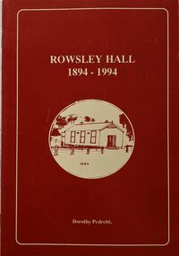 Bacchus Marsh & District Historical Society
Booklet, Rowsley Hall 1894-1994
Rowsley is a rural locality 6km south-west of Bacchus Marsh. It is a very small community and the Rowsley Hall has been a community meeting place for over 100 years. This history tells the story of the origin of the Hall and its place in the community's history for its first 100 years. Citation: Rowsley Hall, 1894-1994, by Dorothy Pedretti. Published by Bacchus Marsh and District Historical Society, Bacchus Marsh, Vic., 1995?A small booklet. 36 unnumbered pages. Stapled binding. Contains black and white photographs, maps and facsimiles of documents. BMDHS Loc: AR/SU5/Pamphlets Box 4Rowsley is a rural locality 6km south-west of Bacchus Marsh. It is a very small community and the Rowsley Hall has been a community meeting place for over 100 years. This history tells the story of the origin of the Hall and its place in the community's history for its first 100 years. Citation: Rowsley Hall, 1894-1994, by Dorothy Pedretti. Published by Bacchus Marsh and District Historical Society, Bacchus Marsh, Vic., 1995?rowsley victoria history, halls, rowsley hall -
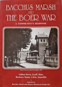 Bacchus Marsh & District Historical Society
Book, Bacchus Marsh and the Boer War: A Community's Response
An account of the impact of the Boer War upon the community of Bacchus Marsh. Like many communities across Australia Bacchus Marsh saw a number of men enlist in the military forces and participate in the conflict in South Africa between Great Britain and its allies such as Australia against the Boer forces in South Africa in the early 1900s. This work documents this history from the perspective of the individual soldiers involved and the way the community responded to this conflict. Citation: Bacchus Marsh and the Boer War: A Community's Response. By Gillian Davis, Geoff Hine, Barbara Manly and Chris Stancliffe. Published by Bacchus Marsh and District Historical Society, Bacchus Marsh, Vic., 2001.A printed book published in paperback edition. 92 pages, with illustrations, portraits, and maps. BMDHS Location: AR/SU4non-fictionAn account of the impact of the Boer War upon the community of Bacchus Marsh. Like many communities across Australia Bacchus Marsh saw a number of men enlist in the military forces and participate in the conflict in South Africa between Great Britain and its allies such as Australia against the Boer forces in South Africa in the early 1900s. This work documents this history from the perspective of the individual soldiers involved and the way the community responded to this conflict. Citation: Bacchus Marsh and the Boer War: A Community's Response. By Gillian Davis, Geoff Hine, Barbara Manly and Chris Stancliffe. Published by Bacchus Marsh and District Historical Society, Bacchus Marsh, Vic., 2001.bmdhs publication, south african war 1899-1902, boer war 1899-1902, soldiers bacchus marsh vic. -
Friends of St Brigids Association
Book - Letters from Irish Australia 1825-1929, O’Farrell, Patrick James. 1984. Letters from Irish Australia 1825-1929. Sydney : New South Wales University Press ; Belfast : Ulster Historical Foundation, 1984 244 p. : ill., maps ; 25 cm
-
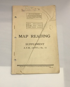 The 5th/6th Battalion Royal Victoria Regiment Historical Collection
Booklet - Book, Map Reading No. 13 1942, 1942
Military guide to map readingBook made of yellowed paper with black print. It is bound by two staples and has three holes punched into the left side for storage in a ring binder. There is a crease that runs from the bottom left to the top right of the cover.wark vc club, military manuals, ww2, regimental property -
The 5th/6th Battalion Royal Victoria Regiment Historical Collection
Book, Manual of Map Reading, Photo Reading and field Sketching 1929, 1929
Pam with brown card cover. Has a Royal coat of Arms located above the title. Has several fold out maps, many of which protude from the book. On a number of the 160 pags there are diagrams which are printed in limited colour.J.G.Bowe is hand written at the top right hand corner in black ink.regimental property, wark vc club, inter war, manual -
 The 5th/6th Battalion Royal Victoria Regiment Historical Collection
Map, Britain and Underground Railways, July 1919
Used by Australian Soldiers whilst on leave after WW1.Reversible map made of paper. One side has a map of Britain and Ireland printed in colour, the other has a map of the London underground as well as several advertisements. there are small tears along the fold lines.wark vc club, regiment property -
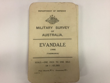 The 5th/6th Battalion Royal Victoria Regiment Historical Collection
Map, Military Survey of Australia. Evandale (1939) (Tasmania), 1939
Fabric backed colour map, with card cover that folds into a small book. Scale one inch= one mile.military, survey, map, tasmania, ww2, wark vc club -
 The 5th/6th Battalion Royal Victoria Regiment Historical Collection
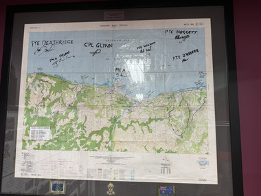
Map - Honiara Map, Honiara West Special used by members of 5/6
Honiara West Special signed by 7 members of 5/6 RVR who were deployed on Operation AnodeThe Map is framed in the glass frame withe the Operation Anode patch, Australian Flag and 5/6 unit symbol displayed below the Map. It has been signed by 7 members of 5/6, each member's PMKey is also displayed on the Map -
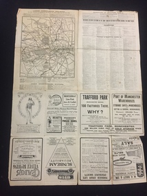
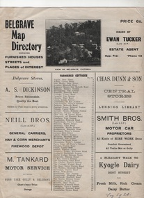 Sherbrooke Foothills Historical Society
Work on paper - Belgrave Map Directory 1920s
-
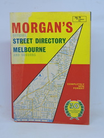 Kilmore Historical Society
Morgan's Street Directory Melbourne, Morgan's Official Street Directory Melbourne and Suburbs, c1966
c1966 Melbourne Street Directory.Soft card cover. 150 maps plus Index. 380 pp. Good condition.Nilmelbourne street directory -
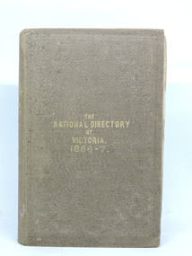 Kilmore Historical Society
The National Directory of Victoria, The National Directory of Victoria. 1866-7, 1866
Butler & Brooke's National Directory of Victoria for 1866-7. Correct and complete map of the Colony, and The Victorian Yearly Advertiser.Brown cloth-bound hardcover book. Embossed border decoration front and back covers. Mildew spotting to front cover and page edges. Front cover partially separated from body. Binding loose. Pull-out page of advertisments before title page. 405 pp. plus advertisements front and back plus Squatting Directory and Towns' Directories. Fair condition.Inside front cover. 'Nesta McKellar'.victorian directory -
 Mont De Lancey
Book, A. H. Massina & Co, A.H. Massina and Co's Weather Almanac and General Guide and Handbook for Victoria for 1894, 1901
A plain red hardcover book - Weather Almanac and General Guide and Handbook for Victoria 1894. A.H.M. & Co's Almanac 1894 - 01. There are maps, calendars, diagrams and general information throughout the book for the guidance of village settlers.A red hardcover Weather Almanac and general Guide and Handbook for Victoria for 1894 - 01 with Calendar and Map of Railway Systems. It has advertisements, tables, calendars, maps, memoranda tables, diagrams and other notes of general interest throughout. non-fictionA plain red hardcover book - Weather Almanac and General Guide and Handbook for Victoria 1894. A.H.M. & Co's Almanac 1894 - 01. There are maps, calendars, diagrams and general information throughout the book for the guidance of village settlers.almanacs, documents, calendars -
Camberwell Historical Society
Booklet (Item), A History of 26 Prospect Hill Road, Camberwell, Victoria
camberwell -
Camberwell Historical Society
Document (Item), Gwen McWilliam, Along the High Street, again, 1994
camberwell, melbourne, high street -
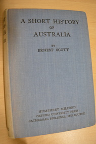 Camberwell Historical Society
Book, Ernest Scott, A Short History of Australia, 1928
398 pages with illustrations and mapscamberwell, australia, history -
Camberwell Historical Society
Book - Photocopied pages from book, Bonwick, James, A Sketch of Boroondara, 1858
Photocopy of 11 pages, including a map, from James Bonwin's bookcamberwell, boroondara