Showing 13823 items
matching tasmanian-built
-
 Eltham District Historical Society Inc
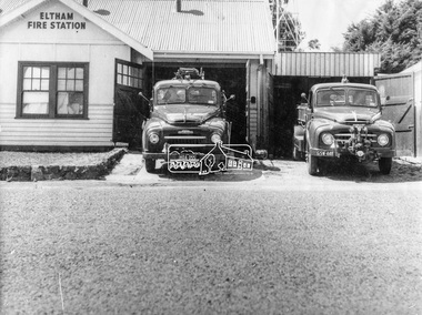
Photograph, George W. Bell, Eltham Fire Station, east side of Main Road, c.Jan 1964
The photograph was taken (and donated) by George W. Bell during the period of fire, c.1963-c.1964. The actual fire station was built c.1930 and was in use till c.1964 when a new fire station was built on the opposite side of Main Road. The building, originally situated just south of Arthur Street, on Main Road was ultimately relocated in 1970 to Research Park for use by the 1st Research Scout group. The site is now part of the current Coles supermarket and Eltham Village complex. The Fire Trucks are an Austin STU (small town unit) on the left and an Austin urban pumper on the right. This photo forms part of a collection of photographs gathered by the Shire of Eltham for their centenary project book,"Pioneers and Painters: 100 years of the Shire of Eltham" by Alan Marshall (1971). The collection of over 500 images is held in partnership between Eltham District Historical Society and Yarra Plenty Regional Library (Eltham Library) and is now formally known as 'The Shire of Eltham Pioneers Photograph Collection.' It is significant in being the first community sourced collection representing the places and people of the Shire's first one hundred years.Digital imageaustin stu fire truck, austin urban pumper, eltham, eltham fire brigade, fire station, fire truck, george w. bell, motor vehicles, shire of eltham pioneers photograph collection -
 Orbost & District Historical Society
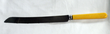
bread knife
This knife was used by Lottie Rem who ran the cookhouse at Astergren;s Timber Mill at Cabbage Tree in East Gippsland from 1954 until 1966.. It was bought in Orbost around 1957 - 1958. Sited on the banks of the Cabbage Tree Creek, the township was built by the timber mills to house their workers. Although the timber mills have disappeared, some of the buildings still remain. The "Cook House" and "Manager's House" are two buildings. The Cook House was built to supply meals to the workers of the Alstergren Mill. Some of the original interior walls were made from hessian and wallpaper. The few houses to survive to today are now used as private dwellings.The Cabbage Tree Creek township was established to support the booming timber industry of the mid 20th century. Five timber mills worked full time supporting the families that were drawn to the area's wealth of natural resources. this item is associated with the history of Cabbage Tree.A stainless steel serrated edged knife with a cream coloured handle (bone?)on blade -""Made in Sheffield expressly for Orbost Hardware and Timber Co, Orbost"alstergren-timber-cabbage-tree rem-lottie cook-house-alstergren's-timber-mill bread-knife-orbost-hardware -
 Eltham District Historical Society Inc
Negative - Photograph, J. P. Lind, Hurst's Bridge, 1885
Looking northwest onto the first bridge at Hurstbridge, 1885. Timber bridge amid rural setting. Two horses graze in an open paddock in the foreground. A house is situated on a rise behind the bridge on a tree lined hill. The area of Hurstbridge was originally known as Hurst’s-bridge after the timber bridge built over the Diamond Creek near Hurst’s station in late 1881/early 1882 on the Hurstbridge-Arthurs Creek Road, Hurstbridge. It was built by John McDonald, of Arthur's Creek and was demolished and replaced in 1917 by a reinforced concrete arch bridge designed by John Monash. Cross Reference Photo No.(s): 1012/1013This photo forms part of a collection of photographs gathered by the Shire of Eltham for their centenary project book, "Pioneers and Painters: 100 years of the Shire of Eltham" by Alan Marshall (1971). The collection of over 500 images is held in partnership between Eltham District Historical Society and Yarra Plenty Regional Library (Eltham Library) and is now formally known as 'The Shire of Eltham Pioneers Photograph Collection.' It is significant in being the first community sourced collection representing the places and people of the Shire's first one hundred years.Digital image 4 x 5 inch B&W Negshire of eltham pioneers photograph collection, hurstbridge, bridge, diamond creek (river), diamond creek (creek), hurst's bridge -
 Bendigo Historical Society Inc.
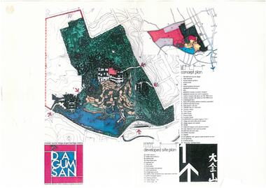
Document - Dai Gum San Concept Plans - Chinese Tourist Village Bendigo Victoria, 1980s
During the first goldrush of the 1850s, Chinese miners referred to the Bendigo region (then Sandhurst) as Dai Gum San 大金山 - literally 'Big Gold Mountain'. The Golden Dragon Museum is situated in the city of Bendigo, Victoria, Australia. The museum is dedicated to the culture and history of Chinese Australians, particularly in the region. Built on the historical site of one of Bendigo's Chinatowns, the museum's precinct also includes Chinese Gardens and a temple to Kuan Yin. Through the museum accreditation program, it was the first accredited museum in Victoria and opened in 1991. These plans are the original plans before the the Golden Dragon Museum was built on its current site.Dai Gum San Concept Plans - Chinese Tourist Village Bendigo Victoria - 4 Sheets in colour by Stephenson and Turner Victoria Architects and Planners Sheet 1 Concept Plan and Developed Site Plan Sheet 2 Arts and Crafts Buildings Sheet 3 Restaurant, Historical Museum and Temple Complex Sheet 4 Motelhistory, bendigo, eaglehawk, chinese, chinese museum, dai gum san -
 Surrey Hills Historical Society Collection
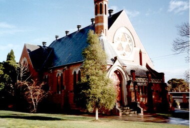
Photograph, St Stephen's Presbyterian Church, Surrey Hills, viewed from Warrigal Road, 1980's
The first service of the Surrey Hills Presbyterian Church was held at ‘Kinnoul’, the home of Thomas Hogg, located in The Avenue. This was while the church was being built. St Stephens Presbyterian Church opened in March 1899 on land that had previously been part of Klepper's orchard. The first minister was Rev F A Darling. He resigned in 1892 to open Surrey College. The church building pictured was built in 1910 adjacent on land gifted to the church. Noted features of the interior are the pulpit and honor board carved by sculptor John Kendrick Blogg. There are also memorial windows to Charles de Burgh Hogg and William Thomas Hogg, both killed in WW1.Red brick church with bell tower and slate roof. Cyprus tree at side; other trees fronting Canterbury Road.Canterbury Road - Warrigal Rd (written in biro on th back of photo)stained glass, lead lights, churches, presbyterian church, st stephens presbyterian church, 1980-1989, surrey hills, canterbury road, warrigal road, john kendrick blogg, charles de burgh hogg, thomas william hogg -
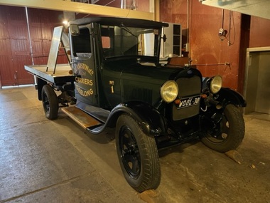 National Wool Museum
Vehicle - Ford Truck, Ford Motor Company, 1930
1930 AA Ford 1.5 tonne (30cwt) truck. Originally owned by Blakiston & Company, Geelong. Built in 1930, this truck carried wool and general goods in Geelong and the Western District until the early 1940s. It was restored in 1989-1990 by David Malkit Automotive, Belmont, Geelong East Technical School. Specifications: 4 cyclinder side valve engine 201 cu.in. capacity 24 hp (R.A.C.) rating 40 bhp @2200rpm Optional 4 speed non-synchronised gearbox Heavy duty rear axle with torque rod Transverse front springs Cantilever back springs Coach built cab and tray bodyDark green truck with painted lettering on door and tray. The cabin has a black bench seat, and body has a wooden tray.printed: NATIONAL WOOL MUSEUM / GEELONG / BLAKISTON & Co. / Pty. Ltd. / CARRIERS / GEELONG / No 1 Licence plate: WOOL - 30ford, truck, transport, 1930s, vehicles -
 Port Fairy Historical Society Museum and Archives
Photograph
John J. Huntly appears to have been the only licensee of the Royal Oak Hotel, built in 1858. Commercial Hotel Bank Street Port Fairy Formerly known as The Royal Oak and then renamed The Royal Oak in the 1990's. A verandah was added in 1900. Around 1877 the hotel various rooms for visiting doctors and a dentist. Dr Berncastle who was associated with the Sydney Eye Infirmary performed several operations there on those suffering from cataracts. It was the meeting place for the Port Fairy Freemasons, before their lodge was built in James Street and all local sporting clubs at one time or another. Also a Cobb & Co staging post.Large Black and white Photograph of the Commercial Hotel Left hand top corner in Ball point pen- PRESENTED BY MR RON McLEAN Right hand top corner in pen - COMMERCIAL HOTEL Museum Number - 62.04B.012hotel, bank street, port fairy, doctor berncastle, commercial, royal oak, sydney eye infirmary, freemasons, lodge, cobb and co, livery stables -
 Lauriston Girls’ School (incorporating Lauriston Museum and Gallery)
Photograph, Brocklesby Lauriston (1914)
[Information from Helen Laidlaw who is researching a history of an immigrant family from Lincolnshire] One of the nine children of this family was Mrs W.B. (Charlotte) Jones, who with her husband built “Brocklesby” in 1866. Mrs Jones was widowed in 1889, and sold the house in 1902. (She then moved to the white house next door to the Lauriston staff car park) The house was designed by Melbourne architect Lloyd Taylor, who also built Bond Stores for Mr. WB Jones. The Bond Stores are still standing. Ms. Laidlaw surmised that the children in the photos were probably Mrs Jones’ grandchildren, born from 1887. -
 Lauriston Girls’ School (incorporating Lauriston Museum and Gallery)
Photograph, Macvean Family at Brocklesby, 1894
Information from Helen Laidlaw who is researching a history of an immigrant family from Lincolnshire. One of the nine children of this family was Mrs W.B. (Charlotte) Jones, who with her husband built “Brocklesby” in 1866. Mrs Jones was widowed in 1889, and sold the house in 1902. (She then moved to the white house next door to the Lauriston staff car park) The house was designed by Melbourne architect Lloyd Taylor, who also built Bond Stores for Mr. WB Jones. The Bond Stores are still standing. Ms. Laidlaw surmised that the children in the photos were probably Mrs Jones’ grandchildren, born from 1887.Lottie Macvean (daughter of W. Jones), and her children Maffra, Olive, Gertrude at Brocklesby, 1894. -
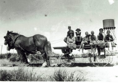 Phillip Island and District Historical Society Inc.
Photograph, Picnic at Nobbies, 1917
The double-storey homestead with 1920s Arts and Crafts styling was built by A.K.T. (Albert Keaston Trenavin) Sambell, the the island’s first shire president. It sits just above the original site of the homestead of the pioneering McHaffie brothers, the Island’s first settlers.HistoricalLarge black and white photograph of a flat topped cart with no sides, pulled by 2 draught horses. Water tank on stand in rural background & people sitting on the cart. 3 women wearing hats and 4 boys, one holding a cricket bat.Off to the Nobbies for a day's picnic - 1917 from "Trenavin Park". Keaston Sambell driving. Sitting behind him - Betty Parker and on side of vehicle from left.-May Lambert, Jim Patterson, Jim Blake, Carmen Sambell, Bill Sambell.trenavin park phillip island, a.k. t. sampbell, betty parker, jim patterson, jim blake, carmen sambell, bill sambell, may lambert -
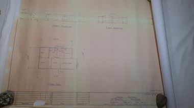 Kiewa Valley Historical Society
Plan - Mt Beauty House
Mt Beauty was a construction town built from 1948. The houses were English Pre-cut Types - several of each type were erected with several variations. This house had 3 bedrooms and is dated as 'traced on 18 Dec. 1956'. Mt Beauty is a construction town built by the SECV during the Kiewa Hydro Electric Scheme for workers and their families. Houses were provided along with many other facilities eg. schools. This house plan is a good indication of the quality of housing provided at the time eg. laundry, toilet etc. Large sheet with title at top "State Electricity Commission of Victoria" showing 'front', 'right' and 'left' elevations and the 'floor plan'. Printed at the bottom - 'Kiewa Scheme / Mt Beauty Housing / English pre-cut Type 3B ILA /. There are further notes printed at the bottom of the sheet.mt beauty housing, english pre-cut type housing, house plan, state electricity commission of victoria -
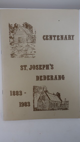 Kiewa Valley Historical Society
Book - Dederang, Centenary St Joseph's Dederang 1883 - 1983 by Jack Goonan & Edna Arundel
The Catholic Church in Dederang began with services in peoples' homes whenever a priest was available 2 or 3 times a year. The priest would ride from Myrtleford. The first church was built in 1883 and was used by families in the Ovens, Kiewa and Mitta valleys.The church was used by residents in the Kiewa Valley. It describes conditions and life styles of the time. Also peoples' religious beliefs and commitment. It includes a biography of the local families in Dederang.Cream coloured cardboard cover with brown fancy font printed title and with 2 sketches of the church one on the top left and one on the bottom right of the cover. It has 48 pages printed on both sides and is held by 2 staples"From Mrs Brian Ford / Gundowring to the / K.V. Historical Society" is handwritten in ink on the top right of the cover page.dederang, st josephs catholic church, kiewa valley, edna arundel, jack goonan -
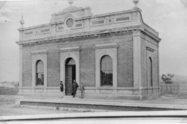
 Port of Echuca
A coloured rectangular photograph, November 1979
This photograph was taken from Hare Street and shows the City of Echuca council offices, before the Shire of Campaspe came about. As the Shire got bigger these offices were extended, and in 2010 the new Echuca Libray was built on the west side of this building.This photograph is significant because it shows the City of Echuca building at the end of the 1970's.A coloured rectangular photograph of the City of Echuca offices, taken in 1979 from Hare Street.Stamped in red on the back 'Print made by Kodak M Nov. 79. It's Kodak for Color.' In blue pen in the top left hand corner is an uppercase R. shire of campaspe, city of echuca, hare street, 1979 -
 Eltham District Historical Society Inc
Photograph, Fay Bridge, Ruins of the old Warrandyte Battery, 7 November 2016
Remains of the timber foundation of the State Battery, built here in 1897 can be seen on the banks of the Yarra River just east of the Warrandyte Bridge on the Warrandyte side of the river. The Battery was driven by waterwheel and was used to crush ore from the Warrandyte Goldfields.fay bridge collection, 2016-11-07, warrandyte battery, ruins -
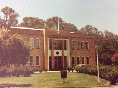
 Eltham District Historical Society Inc
Photograph, Jim Connor, Avenue of Honour, Main Road, Eltham, 3 Apr 2021
Former Eltham Courthouse, 730 Main Road immediately prior to major restoration works undertaken by Nillumbik Shire Council. The Courthouse is the oldest public building in the shire. It was built in 1860 and ceased operations as part of the Court of Petty Sessions in 1985.Tomorrow's history documented todayeltham, jim connor collection, main road, eltham gateway, eltham courthouse, eltham justice precinct, avenue of honour -
 Phillip Island and District Historical Society Inc.
Photograph, 1978/9
Charlie Richardson was the son of William Richardson and grandson of Joseph Richardson who arrived on Phillip Island in 1868. The house at Rhyll was built by William Richardson who went to live at Rhyll in 1876 on land, owned by his father, opposite the Jetty.Coloured photograph showing the Kitchen of Mr Charlie Richardson's home, opposite the Rhyll Jetty.local history, photographs, buildings - historical, housing, coloured photograph, john cook, phillip island, charlie richardson -
 Phillip Island and District Historical Society Inc.
Photograph, 1978/79
View of 18" thick mud brick walls in Chicory Kiln. This was built by Mr T Woods approx. 1870, Settlement Road, East Cowes. Two chicory sowers shown in photograph. Man in photograph is probably Mr T Woods.Photograph of the 18" thick mud brick walls at the core of the old Chicory Kiln on Mr T Woods house, Settlement Road, East Cowes.local history, photographs, buildings - historical, housing, rural industry, coloured photograph, john cook, phillip island, t woods -
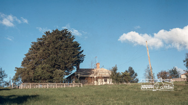
 Phillip Island and District Historical Society Inc.
Photograph, Anderson Family & Homestead
Glen Isla built in 1868 by Robert Anderson, additions 1987 - 88. Had several owners subsequently, bought again into family by Grandson Stan Anderson but sold when he died. Now owned and restored by Mr & Mrs Lunn.Distant view of Glen Isla House depicting rural setting and Western Port Bay glimpse in background.local history, photography, photographs, slides, film, glen isla house, phillip island, sepia photograph, mrs emma anderson jacobs -
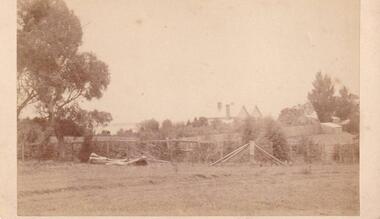
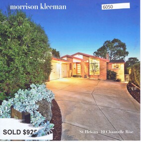 Greensborough Historical Society
Advertising Leaflet, 10 Chantelle Rise St Helena, 14/11/2016
10 Chantelle Rise St Helena. 4 bedroom house. Sold 14/11/2016 for $925,000. Previous sales: December 2007 for $507,500, January 1997 for $200,000, August 1993 for $160,000 and June 1988 for $199,700. Built 1985.Real Estate advertising leaflet,1 sheet folded into 4 pages, printed in colour both sides. 2 copies.chantelle rise st helena -
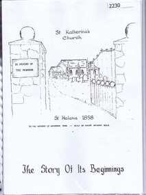 Greensborough Historical Society
Folder, St Katherine's Church St Helena: the story of its beginnings, 1858o
The article in this folder tells the story of the origins of St Katherine's Church St Helena which dates from1858. The Church was built by Major Anthony Beale in memory of his wife Katherine Rose Beale. Includes photographs of the Church and its interior.Grey covered folder with plastic pockets containing article with text and some colour photographs.st katherines church st helena, anthony beale -
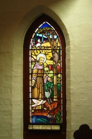 Greensborough Historical Society
Photograph - Digital image, Marilyn Smith, St Katherine's Church St Helena: Window 7, 29/05/2015
St Katherine's Church St Helena dates from 1858. The Church was built by Major Anthony Beale in memory of his wife Katherine Rose Beale. This photograph shows one of the stained glass windows, dedicated to William Shearer Wilson. Digital copy of colour photographst katherines church st helena, anthony beale, william shearer wilson -
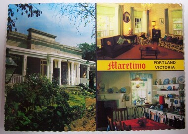 Glenelg Shire Council Cultural Collection
Postcard - Postcard - Maretimo House, Portland, n.d
Maretimo was built in around 1854 for John McLeod. It was purchased by Robert Matheson in 1874 with the next owner being Hugh Campbell in 1895. In 1925 sisters Eleanor Downing and Edith Smith bought the home and lived there. They operated a summer guest house.Postcard showing Maretimo House in Portland.maretimo, home -
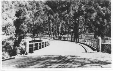 Halls Gap & Grampians Historical Society
Photograph - Photocopy, C 1930s
The third Delley's Bridge, a timber and concrete structure with a curved deck, built in 1940. It was situated slightly upstream from the previous bridge. After nearly 50 years of its use, wear and tear necessitated a fourth bridge to be erected in 2001.The picture shows a curving bridge with a wood and wire railing. An unsurfaced road crosses the bridge and the area is surrounded by trees.structures, tents -
 Eltham District Historical Society Inc
Photograph, Fred Mitchell, Sunnyside, 82 Bible Street, Eltham, 1968, 1968
Original home of W.J. Taylor and family who owned all the land looking west from the house to the Diamond Creek. Hence, Taylor Street. Located on top of the hill, the home was built c.1885 and still stands today (No. 82). Digital copy of colour photographfred mitchell collection, 1968, bible street, eltham, houses, w.j. taylor, sunnyside -
 Port Melbourne Historical & Preservation Society
Photograph - Yacht SJS, Lagoon, Port Melbourne, Ben STENNIKEN, 1920
The original is owned by Ben STENNIKEN. This photograph was the only one of the wall of the Beach Street home of Eli ('Dick') EDWARDS, leading yachtsman who skippered the SJS winning all races. The yacht was built at the Stenniken's home in Rouse Street at Dow.Copy of copy of Ben STENNIKEN's photo of the famous yacht SJS in the Lagoon 1920. Town Pier, Western jetty and Harper's in background.sandridge lagoon, piers and wharves - town pier, piers and wharves - miscellaneous, sport - yachting, sarah jane stenniken, sjs -
 Port Melbourne Historical & Preservation Society
Photograph - 51 Esplanade West Port Melbourne, Janet BOLITHO, c.2006
House built in the inter-war period. Council approved a four 3 storey development with 8 on-site car parks in 2008. It was appealed to VCAT but unsuccessfully and the house was demolished in December 2010. Fire destroyed much of the building prior to ademolition.Colour photograph of Ron in porch at 51 Esplande West, Port Melbourne.built environment - domestic, built environment - demolition, esplanade west -
 Victorian Interpretive Projects Inc.
Photograph - Colour, Michael Taffe, Hymettus Cottage, Ballarat, c1983
Hymettus won the Caulfield Cup in 1898 and the owners built this house, near Lake Wendouree, with the winnings. It won the title of Ballarat's Champion Cottage from 1915-18. The cottage contains many of the original furnishings and fittings and has beautiful gardens. Two digital images of Ballarat's hymettus Cottage. .1) The garden as it was before the 1980s drought. .2) The Cottagehymettus, hymettus cottage, garden, flower, taffe -
 Uniting Church Archives - Synod of Victoria
Photograph, Undated c.1880
The Wesleyan Church was located at the corner of Burwood Road and William St. Hawthorn. It was designed by Messrs. Crouch and Wilson. The foundation stone was laid by the Hon. Alexander Fraser MLC on 14 August 1867. The Sunday School next to the church was built in 1878.Sepia carte de visite photograph of the Wesleyan Methodist Church located at the corner of Burwood Road and Williams Street Hawthorn.Burwood Road, Williams Roadwesleyan church, hawthorn, crouch and wilson, hon. alexander fraser -
 Stawell Historical Society Inc
Photograph, Stawell Shire Hall 1866 c1876
Stawell Shire Hall built 1866, this photo may have been taken in 1876. A copy of each was made and donated to the society by Melbourne Museum. Three people standing outside the front door may be one adult and 2 children. Early view of the Stawell Shire Hall c 1876 before the building was extended. In more recent photos the building has 3 side windows. Three people are standing outside the building entrancestawell -
 Stawell Historical Society Inc
Photograph, McKellar Building in Upper Main Street Stawell in c 1992
Coloured photo McKellar Building c 1876. The colour photo was taken in 1992. The information in Album 4 page 40 states the building was built after fires of c 1866 & 1874. Mr. George Inskip was the architect of the McKellar building.Two colour copies of the McKellar building taken by Geoff Oates in 1992. The two identical photos just show the upper two stories of the building. Stawell 1876 Building Gold Reef Mall. Nov 1992 stawell business