Showing 1506 items matching "acres"
-
 Ballarat Heritage Services
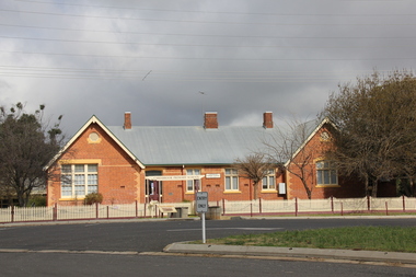
Photograph - Photograph - Colour, L.J. Gervasoni, Carisbrook Primary School no. 1030, 06/08/2011
Carisbrook State School No 1030 was firsy opened on 01 July 1855 as the non=vested Church of England School No 130., becoming a Cmmon School in 1869. A new site was sought, and a two acre corner allotment was selected, being excised from the Police Reserve in October 1873 in Victoria Street.Brick school building at Carisbrook, Victoria. carisbrook, carisbrook primary school, education, carisbrook state school -
 Warrnambool and District Historical Society Inc.
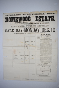
Original document, Advertising "Homewood Estate" Terang, 1886
This notice advertises the sale of the Homewood property near Glenormiston. The sale details state that the property is 2386 acres adjoining "The Sisters" the station of the Black Brothers. The property lies on the main metal road from Terang to Ellerslie, six miles from Terang. It has frontage to Pejark Marsh/drain. It was to be surveyed and sold in blocks of 250 to 300 acres with permanent water and well covered with grasses. The sale of the property followed the death of Charles Podger who died in 1886. On his death he left his wife Ann and six children.His worth was over 20000 pounds with 16000 pounds as real estate and 4300 pounds in personal propertyThe Agent for the sale was James Jellie, solicitors were Warrnambool firm Klingender and O'Mahony and the advertisement was printed by Thomas Smith Gas printing Works Warrnambool. This document has local interest and significance as an early sales of land in the district. The names of agents , solicitors and printers were wll known in the area and the property also a large holding. The Podger name is also well represented in the district to this day.Large white rectangular sheet of paper with black text . Major sale details in heavy black text at the top with descriptive text accompanying map of subdivision of the property on the left.The following names and details are contained within the document. Homewood Estate, Charles Podger, Commercial Hotel Terang, James Jellie Fenelon Mott Surveyor, Klingender & O'Mahony solicitors, Thos, Smith Gas Printing Koroit Street Warrnamboolcharles podger, homewood estate, klingender, o"mahony, kolora, the sisters, terang -
 Wodonga & District Historical Society Inc
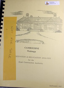
Booklet - Cambourne Wodonga : Conservation & Relocation Analysis for the Road Construction Authority, John & Thurley O'Conner, 1987
Research paper into the viability of relocating Cambourne Homestead in 2006 in order to make way for the widening and upgrade of the Hume Highway.non-fictionResearch paper into the viability of relocating Cambourne Homestead in 2006 in order to make way for the widening and upgrade of the Hume Highway. cambourne homestead wodonga, heritage building wodonga, carkeek family, potter family, building relocation -
 Greensborough Historical Society
Photograph - Digital image, Frank Robinson, Looking west over Pope's paddock to Main Street, 1954_
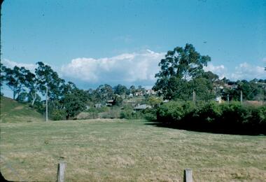
Looking west over Pope's paddock to Main Street. The Blackjack property, house and acres of fruit orchards ran down to the Plenty River off Hume Street Greensborough and was the home of the Robinson family to late 1956. The photographs were taken as slides by Frank Robinson and digitised by his son James in 2015.Digital copy of colour photograph.popes paddock, main street greensborough, blackjack -
 Greensborough Historical Society
Photograph - Digital image, Frank Robinson, Greensborough near Plenty River bridge and football ground, 1954_
Greensborough near Plenty River bridge and football ground. The Blackjack property, house and acres of fruit orchards ran down to the Plenty River off Hume Street Greensborough and was the home of the Robinson family to late 1956. The photographs were taken as slides by Frank Robinson and digitised by his son James in 2015.Digital copy of colour photograph.robinson family, plenty river, blackjack -
 Eltham District Historical Society Inc
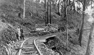
Negative - Photograph, Timber Tramway at Wright's Falls, Kinglake District, c.1920
Man and woman stand beside timber tramway track at Wright's falls Kinglake. The tramway was constructed alongside the road to support the large traffic in firewood between the mountains to Whittlesea. The Wright family owned the land on which the Falls were situated and were sold for a penny an acre according to a Wright family story. This photo forms part of a collection of photographs gathered by the Shire of Eltham for their centenary project book,"Pioneers and Painters: 100 years of the Shire of Eltham" by Alan Marshall (1971). The collection of over 500 images is held in partnership between Eltham District Historical Society and Yarra Plenty Regional Library (Eltham Library) and is now formally known as 'The Shire of Eltham Pioneers Photograph Collection.' It is significant in being the first community sourced collection representing the places and people of the Shire's first one hundred years.Digital image 4 x 5 inch B&W Negshire of eltham pioneers photograph collection, kinglake, timber tramway, wrights falls -
 Whitehorse Historical Society Inc.
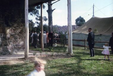
Photograph, Schwerkolt Cottage Opening 1965
Built in 1864 by August Schwerkolt, the cottage was headed for demolition in 1963. Local residence rose up in protest, which led to the Nunawading Council purchasing the cottage and five acres of the surrounds in 1964. By 1965 the cottage had been restored and was opened on 17th October 1965 by Sir Rohan Delecombe, governor of Victoria.11 coloured photographs of Schwerkolt family members at the opening of Schwerkolt Cottage in 1965schwerkolt cottage opening 1965, schwerkolt cottage -
 Melton City Libraries
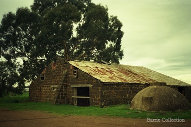
Photograph, Darlingsford Barn, Unknown
In 1853, Thomas Bell Darling purchased 176 acres from the Toolern Creek to Ferris Road. A house and bluestone barn/stables were built. The property was owned by Ralph Parkinson, followed by Richard Manning. “Darlingsford” was the name given to the Homestead. In 1911, Charles Ernest Barrie purchased the property known as“Darlingsford”. Barn before restorationlocal identities, local architecture, council -
 Marysville & District Historical Society
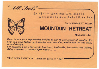
Ephemera (item) - Advertisement, MOUNTAIN RETREAT MARYSVILLE, Unknown
An advertisement for Mountain Retreat near Marysville.An advertisement for Mountain Retreat near Marysville....from Paradise Art Village, 114 Mt Margaret Rd./ Bought from "Angela" in 1985 by the/ Dowling family./ Was an artist's commune from/ about 1968-1985./ Before that was a chicken farm/ owned by the Edwards. (Parents of Betty/ Argent who lived on a 1/2 acre block just/ off from the main block with her husband,/ Charlie Argent.)marysville, victoria, australia, mountain retreat, betty argent, charlie argent, venusian light co, paradise art village, dowling family, advertisement -
 Ringwood and District Historical Society
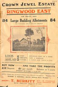
Flyer, Subdivisional Land Sale Brochure, Crown Jewel Estate, Ringwood East, Vic. - c.1925
In May 1884, George Smart of Bulleen Road Kew, brickmaker, bought the 23 acres one rood and twenty nine and three tenths perches, or 9.4834 hctares from Arthur Bailey Clements of Ringwood for the sum of 600 pound sterling. (Extract from The Story of the Crown Jewel Estate in Ringwood East pdf)Double sided folded page with black and red print on both sides advertising auction sale of residential and business sites and highlighting local facilities, services and layout of the estate.Subdivision includes Mount Dandenong Road, Valda Avenue, Evon Avenue, Mirabel Avenue, and Velma Grove. (Agent) T. Burkitt, Box 12 Ringwood, Phone Ringwood 157. Vendor: A. Marshall Miller, McDonald Street, Mordialloc. Solicitors: Russell, Bona and Russell, 19 Queen Street Melbourne, and Ringwood - Phone Cent. 4308. -
 Phillip Island and District Historical Society Inc.
Newspaper clippings, 6/12/1973
Account of opening of Newhaven Marina by Sir Rupert Hamer. A special State Government Bill annexed 10 acres of foreshore for the Marina. A $26,000 Government guaranteed loan financed much of the work. Mr Dunstan, Minister of Public Works and Shire of Phillip Island President, Cr. Trafford Morgan-Payler, both spoke.Article on opening of Newhaven Marina.local history, documents, newspapers, newhaven marina, newspaper clippings, black & white newspaper clipping, sir rupert hamer, newhaven marina, mr dunstan minister for public works, cr trafford morgan-payler, shire of phillip island president -
 Greensborough Historical Society
Photograph - Digital image, Frank Robinson, Looking across the Plenty River from Pope's paddock to Blackjack, 1954_
Looking across the Plenty River from Pope's paddock to Blackjack. The Blackjack property, house and acres of fruit orchards ran down to the Plenty River off Hume Street Greensborough and was the home of the Robinson family to late 1956. The photographs were taken as slides by Frank Robinson and digitised by his son James in 2015.Digital copy of colour photograph.blackjack, popes paddock, robinson family -
 Greensborough Historical Society
Photograph - Digital image, Frank Robinson, Looking south east from Pope's paddock to the railway line, 1954_
Looking south east from Pope's paddock to the railway line. The Blackjack property, house and acres of fruit orchards ran down to the Plenty River off Hume Street Greensborough and was the home of the Robinson family to late 1956. The photographs were taken as slides by Frank Robinson and digitised by his son James in 2015.Digital copy of colour photograph.robinson family, popes paddock -
 Greensborough Historical Society
Photograph - Digital image, Frank Robinson, Looking south west from Pope's paddock to the swing bridge, 1954_
Looking south west from Pope's paddock to the swing bridge. The Blackjack property, house and acres of fruit orchards ran down to the Plenty River off Hume Street Greensborough and was the home of the Robinson family to late 1956. The photographs were taken as slides by Frank Robinson and digitised by his son James in 2015.Digital copy of colour photograph.robinson family, popes paddock, blackjack -
 Greensborough Historical Society
Photograph - Digital image, Frank Robinson, North end of Pope's paddock looking west to township, 1954_
North end of Pope's paddock looking west to township of Greensborough. The Blackjack property, house and acres of fruit orchards ran down to the Plenty River off Hume Street Greensborough and was the home of the Robinson family to late 1956. The photographs were taken as slides by Frank Robinson and digitised by his son James in 2015.Digital copy of colour photograph.robinson family, blackjack, popes paddock -
 Greensborough Historical Society
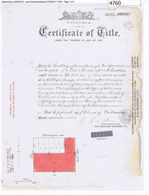
Certificate of Title, Certificate of Title Vol. 3182 Fol. 302, 15/02/1907
Title in the name of Joseph Laidlay of Greensborough, fruitgrower, 14 acres being Lots 7, 8 and 22 on Plan of subdivision 4759, part of Crown portion 17, Parish of Keelbundora County of Bourke, dated 15th February 1907. Northern boundary Greensborough (now Grimshaw) Road, Eastern boundary Henry Street.1 p. colour copy of Titlegreensborough, grimshaw street greensborough, henry street greensborough, joseph laidlay -
 Ballarat Heritage Services
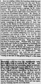
Newspaper - Newspaper article, Newsclipping Relating to Stonemason Julien Hardy
Julien Hardy was the first discoverer of gold at Happy Valley. A stonemason, he was born at Vire, Normandy, France. He established a stone quarry on the Melbourne Road, near Warrenheip (on the site now occupied by Shady Acres Caravan Park). From here, he quarried blocks that were used in the Ballarat Town Hall.Newsclippingjulien hardy, stonemason, gold, happy valley, shady acres, warrenheip, ballarat town hall -
 Eltham District Historical Society Inc
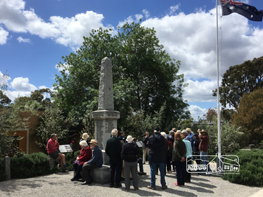
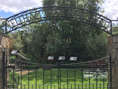
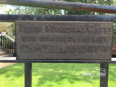
Photograph, Peter Pidgeon, Eltham War Memorial, 903-907 Main Road, Eltham, 4 November 2017, 4 Nov 2017
Eltham District Historical Society heritage walk to follow the boundaries of the original Shillinglaw Farm in central Eltham, held Saturday, 4th November, 2017. The Shillinglaw Farm comprised Lot 90 of Holloway’s 1851 Little Eltham subdivision. It was originally 30 acres in area and situated east of the Diamond Creek and north of Henry Street.Born digital imageeltham war memorial, obelisk, war memorial buidings, war memorial hall -
 Eltham District Historical Society Inc
Photograph, Peter Pidgeon, Eltham War Memorial, 903-907 Main Road, Eltham, 4 November 2017, 4 Nov 2017
Eltham District Historical Society heritage walk to follow the boundaries of the original Shillinglaw Farm in central Eltham, held Saturday, 4th November, 2017. The Shillinglaw Farm comprised Lot 90 of Holloway’s 1851 Little Eltham subdivision. It was originally 30 acres in area and situated east of the Diamond Creek and north of Henry Street.Born digital imagecr. e.j. andrew, eltham war memorial, ernie andrew, war memorial buidings, war memorial garden, war memorial gates -
 Greensborough Historical Society
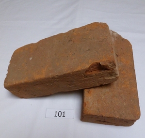
Functional object - Bricks, Hand made bricks from Partington house (Willis Vale) Greensborough, 1840c
Bricks from "Willis Vale' home of the Partington family of Greensborough. Built in 1840, Willis Vale was owned by the Partington family from 1878 to 1947. It was a 2 storey house overlooking the Plenty River and set in 150 acres of farmland. The Partingtons moved out in 1947 and the house was vandalised shortly after. It was destroyed by fire in the 1960s.The bricks are a link to pioneer homes and farms in the area.Hand made clay bricks, light red in colour. All faces are flat.. One brick is chipped. Accompanying note: Hand made bricks from Partington house in Greensborough. Donated by Alan Partington.willis vale, partington family, greensborough, alan partington, bricks -
 Greensborough Historical Society
Photograph - Digital Image, Blackjack: Frank Robinson hoeing, 1953_
Frank Robinson hoeing the apricot orchard at Blackjack with son Andrew in rear. The Blackjack property, house and acres of fruit orchards ran down to the Plenty River off Hume Street Greensborough and was the home of the Robinson family to late 1956. The photographs were taken as slides by Frank Robinson and digitised by his son James in 2015.Digital copy of colour photograph.frank robinson, blackjack -
 Greensborough Historical Society
Photograph - Digital image, Frank Robinson, Looking north over the football ground with bridge over Plenty River, 1954_
Looking north over the football ground with bridge over Plenty River. The Blackjack property, house and acres of fruit orchards ran down to the Plenty River off Hume Street Greensborough and was the home of the Robinson family to late 1956. The photographs were taken as slides by Frank Robinson and digitised by his son James in 2015.Digital copy of colour photgraph.robinson family, blackjack, plenty river -
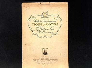 Port Melbourne Historical & Preservation Society
Document, Reprinted by Deepdene Photo Offset Process 1938, Troedel & Cooper Calendar 1939, Original 1863. Reprinted1938
This calendar of early Melbourne scenes was produced in 1938 to celebrate the 75th anniversary of the founding of the firm in Melbourne. The size, layout and images were a copy of the original calendar produced in 1863. In 1938, the company's premises covered an acre in Bay Street, Port Melbourne and Charles TROEDEL (1835- 1906) called himself 'The Father of Lithography in Australia". Pale yellow calendar with Troedel & Cooper logo and small photograph of Charles Troedel above a short history of the firm.charles troedel, troedel & cooper pty ltd -
 Whitehorse Historical Society Inc.
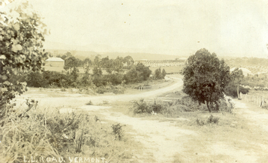
Photograph, L L Road Vermont, late 1800
Dr L L Smith was a pioneer of the Vermont District. He owned 250 acres in the area bounded by Boronia, Canterbury and Heatherdale Roads and the creek. The property was known as L L Vale after which the road was named. Name was changed to Boronia Road in later years. He was a Doctor with rooms in the City, was a member of Parliament.Sepia Postcard of L L Road, Vermont (now Boronia Road) taken in the early 1900s (card is postmarked 27 Aug 1909). Shows the road going down it is presumed to the creek. It is possible that the house is that of Dr.L.L.Smith. See History.|Orchard in background is the Finger orchard. (from Mr. Shambrook - Tim's father)|Information on the back of the Postcard reveal it was sent to Miss Roberts of 61 Hoddle Street Richmond Victoria by Muriel at 37 Victoria Road Northcote and was posted at the Fairfield Post Office Victoria on 27 August 1909. Text is 'Dear Ethel Just a Post Card to let you know I will be out to see you on Monday if convenient. I came down with Mr Hutchinson and he asked me what were we laughing out on the Sunday when he came up. Muriel|See the following references -ND199, 313, 539. 1242, 2013, 3680 & 4295.l l road vermont, boronia road vermont, smith . l l dr -
 Sunbury Family History and Heritage Society Inc.
Photograph, 'Rupertswood', 17 March 1934
'Rupertswood' mansion, in Sunbury, was the former home of Sir Rupert Clarke. His original estate covered 137317 acres in various areas in the district of Bourke in the 1880s. The 'Rupertwood' property was eventually acquired by the Salesian Order and functioned as a boys' school where many were trained in farming skills. In the 1990s it became a coeducational secondary college. The Clarke family acquired and settled much land in the Sunbury area and today 'Rupertswood' Mansion is one of the surviving grand nineteenth century mansions in Victoria. The Catholic Church has also played a prominent role in educating many of the young people in the district. A sepia photograph of the 'Rupertswood' mansion set on a rise with surrounding farmland and some outbuildings.rupertswood mansion, salesian college, catholic church, catholic education, education, schools -
 Bendigo Historical Society Inc.
Document - H.A. & S.R. WILKINSON COLLECTION: CONTRACT OF SALE
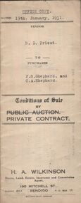
Conditions of sale by private contract dated 19th January, 1931 between R.L. Priest (seller) and F.S. Shepherd & C.A. Shepherd (buyer) for land situate Epsom Road, Eaglehawk Flat, being conditional purchase lease of special settlement area land from the Crow, entered in the register book volume 1001 folio 200107, allotments 152B and 152C section N, containing 15 acres no roods 27 perches at the present occupied by Mr. Hummel as tenant. Together with 5-roomed weatherboard dwelling and all sundry. Price 250 poundsorganization, business, h.a. & s.r wilkinson real estate -
 Bendigo Historical Society Inc.
Document - H.A. & S.R. WILKINSON COLLECTION: CONTRACT OF SALE
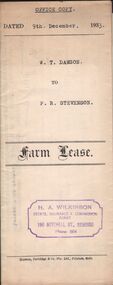
Farm lease dated 9th December, 1933 between W.T. Dawson (lessor) and P.R. Stevenson (lessee) for parcel of land situate in Keck Street, Bendigo approx 2 acres, including dam site with dwellings out-houses and all improvements to have and to hold for a term of 1 year and 4 weeks upon the following conditions: One- the term of tenancy shall be from the ninth of December 1933 to the fifth of January, 1935. Two- that rent for the said term shall be at the clear annual rental of 58 pounds and 10 shillings payable quarterly in advance.organization, business, h.a. & s.r wilkinson real estate -
 Bendigo Historical Society Inc.
Newspaper - JENNY FOLEY COLLECTION: UNITED IRON WORKS
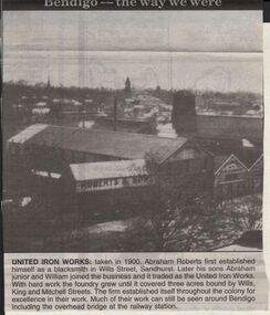
Bendigo Advertiser "The way we were" from 1999. United iron works: taken in 1900. Abraham Roberts first established himself as a blacksmith in Wills Street, Sandhurst. Later his sons Abraham junior and William joined the business and it traded as the United Iron Works. With hard work the foundry grew until it covered three acres bound by Wills , King and Mitchell Streets. The firm established itself throughout the colony for excellence in their work. Much of their work can still be seen around Bendigo including the overhead bridge at the railway station.newspaper, bendigo advertiser, the way we were -
 Bendigo Historical Society Inc.
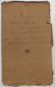
Document - LANDS OFFICE: SANDHURST CROWN LAND SOLD BY AUCTION 1854
Document: LANDS OFFICE: SANDHURST CROWN LAND SOLD BY AUCTION 1854 booklet - brown paper cover with blue pages. On front cover ' copy of sale books, town lots Sandhurst, April 18,19,20,21, 22 and 24 also suburban lots on the Bendigo Creek sold May 10TH.? 1854' Booklet contains copies of advertisement for auctions, written alongside, name of purchaser and amount paid per acre. White sticker fixed to pocket ' Book 1, Sandhurst Land Sales, 10 May 1854 to 18 May 1854Lands Officelands office, bendigo, sandhurst, land sales