Showing 1588 items
matching farming.
-
 Warrnambool and District Historical Society Inc.
Newspaper - The Argus, The Argus Melbourne, 1925
This paper contains mostly news items and advertisements of the day. However some items contained within are fictional in nature.This is an original Argus in a maroon leather folder. The paper itself is a 32 page broadsheet which slides inside the folder for protection. A certificate of authenticity is glued to the inside cover of the folder.non-fictionThis paper contains mostly news items and advertisements of the day. However some items contained within are fictional in nature.warrnambool, the argus 1925, winslow, o'keefe, o'keeffe -
 Greensborough Historical Society
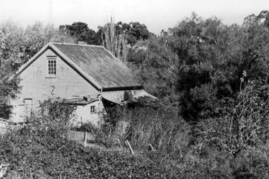
Photograph - Digital Image, Willis Vale, 1950c
Willis Vale: House built by Edward Maygar, Robert Whatmough lived there mid 19th century and later sold to Partington family. It was located on the Plenty River at Partington's Flat Greensborough. Land use included farming and orchards. The derelict Willis Vale house was vandalized in 1964 and destroyed when a fire originating from North Plenty Gorge - Kurrak Road - was lit by two teenage boys and made its way several kilometres down to Partington's Flat Greensborough. This photo was taken after the Partington's moved house in 1947 across the river where Alan built their new Alwyn house that had access to electricity.Home of the Partington familyDigital copy of black and white photograph.willis vale, partington family, whatmough, maygar family -
 Greensborough Historical Society
Photograph - Digital Image, Willis Vale, 1950c
Willis Vale: House built by Edward Maygar, Robert Whatmough lived there mid 19th century and later sold to Partington family. It was located on the Plenty River at Partington's Flat Greensborough. Land use included farming and orchards. The derelict Willis Vale house was vandalized in 1964 and destroyed when a fire originating from North Plenty Gorge - Kurrak Road - was lit by two teenage boys and made its way several kilometres down to Partington's Flat Greensborough. This photo was taken after the Partington's moved house in 1947; across the river where Alan built their new Alwyn house that had access to electricity.Home of the Partington familyDigital copy of black and white photograph.willis vale, partington, whatmough, maygar -
 Eltham District Historical Society Inc
Photograph, Stevenson Homestead "Bankhead", Kangaroo Ground. Robert Stevenson and family
Stevenson, Robert, Kangaroo Ground, was born in the County of Evelyn, Victoria in 1845, He is the son of the late Joseph Stevenson and retains the property purchased by his father, with 47 acres adjoining, making in all 127 acres, where he carries on farming, and also a vineyard, the grapes from which have taken a number of prizes at agricultural societies’ shows at Heidelberg and other places. He was married in 1872, and has a family of two sons and five daughters. From: Victoria and it’s Metropolis: Past and Present by Alexander Sutherland ; R. L. J. Ellery ...[et.al. Melbourne : McCarron, Bird, 1888]. Page. 414 This photo forms part of a collection of photographs gathered by the Shire of Eltham for their centenary project book,"Pioneers and Painters: 100 years of the Shire of Eltham" by Alan Marshall (1971). The collection of over 500 images is held in partnership between Eltham District Historical Society and Yarra Plenty Regional Library (Eltham Library) and is now formally known as the 'The Shire of Eltham Pioneers Photograph Collection.' It is significant in being the first community sourced collection representing the places and people of the Shire's first one hundred years.Digital imagesepp, shire of eltham pioneers photograph collection, kangaroo ground, bankhead, robert stevenson, stevenson homestead -
 Kiewa Valley Historical Society
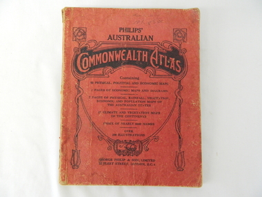
Atlas Australian Commonwealth, Philips' Australian Commonwealth Atlas, 1944
This atlas, printed in 1944, details not only the geographic and political boundaries of the world as it was at that time but also the snap shot of life of the time. This snap shot in time covers the major Australian cities, the major farming, grazing, industrial and sporting/recreational activities. Also there are snap shots of similar activities from other global areas. The period also covered World War II, detailed by a photo of "shell making", munitions, required by Australian soldiers. The great political and territorial changes made as a result of World War II can be clearly identified for example , Israel (the Jewish homeland). The various prewar colonies of major European nations.This atlas was used by children of a Kiewa Valley family and shows the value and the general educational exposure that these children had at this time. The rural setting and within the backdrop of a world war did not severely alter the life style of children in this region. The "news reels" shown in cinemas of cities and larger towns were the only visual realisations of major events of global significance available to these children. The information provided by this atlas allowed students to glimpse at what the "outside world" was. The majority of these students would possibly never see these regions for themselves. The great communication facilities of the late 1900s and beyond, was still only science fiction.This atlas has a thick (350 g/m) red cardboard cover with bold black lettering and shading. The cover is set out within a shield like frame. The shield is held up by two square markings, each with a four part circular pattern and a cord entwining two pendulum structures ending with a bowl figure at the bottom. There is a semi circular form enclosing a printed book contents list. The inside cover has the atlas title and contents and the publisher details. The atlas contain 56 pages of world and Australian maps, vegetation and rainfall maps. Within this atlas there are 27 double sided pages of black and white photographs depicting life styles, buildings, landscapes and prominent and significant to Australia males from 1652 to 1944. The pages are of approximately 200 g/m and have the yellow aged appearance.On front cover "Philips' Australian COMMONWEALTH ATLAS" and underneath "Containing" underneath "60 PHYSICAL, POLITICAL AND ECONOMIC MAPS". Publisher George Philip & Son, Limited 32 Fleet Street, London E.C. 4. Inside cover are: written, in freehand and in ink the following names and dates; "J.Muller Form V 1945", "L L Muller Form IV 1946", "N.J. Muller Form I + II + III 1948 +49 + 50" and "D Muller Form I 1949". also handwritten and in pencil is "Peter Leslie". On the last page is a small freehand sketch of Australia in biro.1940s school curriculum, rural education, 1940s atlas, australian atlas -
 Lake Bolac & District Historical Society
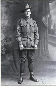
Black and white photograph, Private Louis (Joe) Murdoch Murray, 8th Lighthorse regiment, WW1
Private Louis (Joe) Murdoch Murray, 8th Light Horse Regiment, WW1. Joe enlisted 15/01/1915 and embarked for overseas on 07/05/1915. He served at Gallipoli and in France where he was badly wounded at the battle of Ypres in 1917. After returning from the war he took up farming on land donated to him by the Austin family. However, he never fully recovered either physically or mentally from his war service and lost his farm in the Depression. He spent his final years in an Old Soldiers Home in Frankston. He is buried in Melbourne.murray, 8th light horse regiment, ww1, gallipoli, ypres, austin, old soldiers home - frankston, melbourne. -
 Warrnambool and District Historical Society Inc.
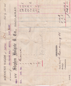
Document - Docket, Wilson & Anderson Jos Tilley 1916, 1916
This docket from the firm of Stephen Holgate and Co. of Ballarat gives details of this firm’s sale in 1916 of nine bullocks on behalf of Joseph Tilley of ‘Aringa’ of Port Fairy. The sale yielded £215-15-0 and, with costs of £14-12-2, the profit for Joseph Tilley was £201-2-10. Stephen Holgate established his auctioneering firm in Ballarat in the late 19th century and was an authority on sheep and cattle breeding. Joseph Tilley was farming at ‘Aringa’ in the early 20th century and also owned the Penshurst Hotel. ‘Aringa’, five miles west of Port Fairy on the Portland Road, was established by John Ritchie in 1839.This docket is of some importance as it is an original one and gives details of a 1916 sale of cattle with the names Joseph Tilley and Stephen Holgate of interest. It gives us the prices for bullocks in 1916 and the type of receipt forms used at that time.This is an original receipt for an account sale of 1916. The docket is a printed one from the firm of Stephen Holgate and Co. of Ballarat with printed blue and red lines for entering the details of the sale. The client’ s name is typed in blue type and the details of the sale are handwritten. On the back of the docket: ‘Wm Delaney from Lin Shoppee’ ‘1916’aringa, joseph tilley, stephen holgate and co. -
 Eltham District Historical Society Inc
Folder, James Johnston
"Johnston, James - Kangaroo Ground, is a scotchman by birth, born in Aberdeenshire in 1812. Arriving in Melbourne in 1840, and spending twelve months on the Plenty, and another similar period on the Darebin Creek, he went in 1842, to the Kangaroo Ground, where he rented a farm from Mr Donaldson for seven years, subsequently purchasing 160 acres of land from the Government at one pound 13s per acre, and also owning 60 acres adjoining, where he carries on farming. Mr Johnston has a family of three sons and four daughters." Sutherland, Alexander Victoria and its Metropolis, v.2 1888 page 434. Folder of information on James Johnston, Kangaroo Ground pioneerjames johnston, pioneer, kangaroo ground -
 Eltham District Historical Society Inc
Film - Video (DVD), Neisha Forbes et al, Tales of Old Nillumbik; stories of life in years gone by - Plenty Historical Society, 15 November 2005
A series of talks held October - December 2005 at the Eltham Living and Learning Centre which allowed Nillumbik Historical Societies to record the verbal history of the area with some of the well known residents of Nillumbik and surrounds Recorded and edited by Marie Ryan of Plenty Valley FM Speaker: Neisha Forbes 15th November 2005 This session covers the early settlement of Plenty. Learn about the mills situated on the Plenty River from the 1840s. Early industry such as fruit growing, poultry farming, goldmining, rabbit skinning and how they contributed to the development and employment of the area and in the case of rabbit skinning the development of other industries in Victoria during the Depressionvideo recording -
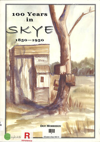 Narre Warren and District Family History Group
Book, Dot Morrison, 100 years in Skye 1850-1950, 2004
The book 100 Years in Skye, 1850-1950 by Dot Morrison explores the history of Skye in a detailed account of the area's development over a century, including its social, economic, and cultural changes. The book's illustrations, maps, and photographs offer a vivid portrayal of life in Skye during this period. Includes an index and bibliography.99 p.; 29 cmnon-fictionThe book 100 Years in Skye, 1850-1950 by Dot Morrison explores the history of Skye in a detailed account of the area's development over a century, including its social, economic, and cultural changes. The book's illustrations, maps, and photographs offer a vivid portrayal of life in Skye during this period. Includes an index and bibliography.skye (vic.), skye (vic.) -- history, skye (vic.) -- road names, wedge family, skye (vic.) -- murders, south lyndhurst state school -
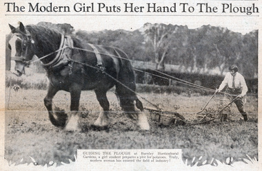 University of Melbourne, Burnley Campus Archives
Newspaper - Newspaper Cutting, The Sun News-Pictorial, The Modern Girl Puts Her Hand To The Plough, 1930
Newspaper cutting with 3 photos (2 copies) from "The Sun News-Pictorial", October 15, 1930. (1) Student ploughing with a cart horse, with the caption: "Guiding the plough at Burnley Horticultural Gardens, a girl student prepares a plot for potatoes. Truly, the modern woman has entered the field of industry!" "Happy students at Burnley Horticultural Gardens thoroughly enjoy the hard work associated with the assimilation of farming and gardening lore. Ploughing, planting, pruning, and all the multitude of tasks in horticulture, come within the practical range of their studies." (2) 5 students walking in formation, with the caption: " A bevy of girls returning to lunch after their morning's work yesterday." and Two students in the orchard with flowering fruit trees, with the caption: "Examining the apple blossom for the implacable foe of the orchardist - thrip. The gardens are kept singularly free of pests."the sun news-pictorial, burnley horticultural college, students, female students, ploughing, horses, students working outside, orchard, apple blossom, thrip, draught horses, potatoes -
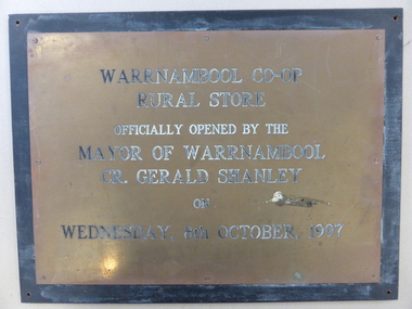 Warrnambool and District Historical Society Inc.
Plaque, Warrnambool Co-op Rural Store, 1997
The Warrnambool Co-operative had its beginnings as the Allansford Artificial Breeders Co-operative in the 1960's. In the 1970s they opened a retail store in Timor Street which had a strong rural and farming base which gradually expanded to become the largest trading department store in the district. By the late 1990's they had 8000 members and employed 84 full time and 120 casual staff. It met a sorry end in the 2000's.This plaque commemorates the opening of the Rural store which consolidated the large rural aspect of the business. It opened up the site from Merri Street at the back of the Timor Street building trading in all agricultural products, , chemicals and fuels.A link to one of Warrnambool's largest stores of the latter part of the 20th century and as such it has historical and social significance. Rectangular brass plaque with stamped black text with eight screws around the edge attaching it to a piece of heavy particle board , painted black.Warrnambool Co-Op rural Store officially opened by the Mayor of Warrnambool Cr. Gerald Shanley on Wednesday, 8th October 1997.warrnambool co-operative society limited, warrnambool co-operative rural store, warrnambool -
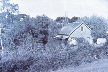
![Photograph - Digital image, Willis Vale [side view], 1950c](/media/collectors/4f729f5697f83e03086015b8/items/5502a2592162f11024c32328/item-media/5502a2852162f11024c3268d/item-fit-380x285.jpg) Greensborough Historical Society
Greensborough Historical SocietyPhotograph - Digital image, Willis Vale [side view], 1950c
Willis Vale: House built by Edward Maygar, Robert Whatmough lived there mid 19th century and later sold to Partington family. It was located on the Plenty River at Partington's Flat Greensborough. Land use included farming and orchards. The derelict Willis Vale house was vandalized in 1964 and destroyed when a fire originating from North Plenty Gorge - Kurrak Road - was lit by two teenage boys and made its way several kilometres down to Partington's Flat Greensborough. This photo was taken after the Partington's moved house in 1947. across the river where Alan built their new Alwyn house that had access to electricity. Home of the Partington family Home of the Partington familyDigital copy of black and white photograph.willis vale, partington, whatmough, maygar -
 Federation University Historical Collection
Document - Document - Advertising pamphlet and related photos and information, ZILLES COLLECTION: Pamphlet for The Munro Hydraulic Multi-Sett Mk II Post Driver; Munro Engineers, Wendouree Victoria
Zilles Printers was begun by Lewis Zilles in the early 1930s. It was in McKenzie Street Ballarat. His son Jeffrey also became a printer - letterpress, offset and screen printer. The business became Zilles Printers/Graphics and was in Armstrong Street and later Bell Street Ballarat. Munro Engineers were pioneers in farming equipment since 1800s. Their main product was a range of fencing machinery. In 1963 they invented and produced the world's first tractor mounted, hydraulic post driver with digger. Advertising material preparations for Munro Engineering of Wendouree. Items included are paste-up of pamphlet, single sheet advertisements and written information, stickers and photographs for the preparation of printed matter.Four page pamphlet - printer's paste-up design plus two single pagesContact information for Munro Engineers. Mechanical information in pencilzilles printers, ballarat, munro engineering, pioneers in farming equipment, fencing machinery, tractor mounted post driver with digger, pamphlets, wendouree -
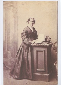 Uniting Church Archives - Synod of Victoria
Photograph, Undated c.1870
Caroline Elizabeth Newcomb (1812 - 1874) woman squatter. Born in London and emigrated to Hobart Town in 1833. She went to Port Phillip in 1836 as governess to the children of John Batman. She met Anne Drysdale in Geelong and they set up a farming partnership. Caroline Newcomb joined the Wesleyan Methodist Society in 1839 and became the first secretary of the Methodist Church at Drysdale, founded in 1849. After Anne's death in in 1853 she continued to run the Coryule property. On 27 November 1861 she married Wesleyan minister the Rev James Davy Dodgson. She died at Brunswick on 3 October 1874. She was buried beside Miss Drysdale at Coryule.Sepia toned enlarged reproduction of original full-length studio portrait of Mrs Caroline Dodgson, formerly Miss Caroline Newcomb. caroline elizabeth newcombe, anne drysdale, rev james davy dodgson, coryule, geelong, hobart town, john batman, squatter, methodist, drysdale -
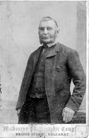 Linton and District Historical Society Inc
Photograph, Melbourne Photographic Company, Bridge St, Ballarat, Mr W.G Bennett, butcher
William Garnsworthy Bennett was at Linton's Diggings in 1856, when he married Susan Williams. Both had migrated from England. W. G. Bennett established a butcher's shop in Linton Township, and later purchased farming land and other town allotments. William and Susan Bennett had twelve children, eight of whom survived to adulthood. W. G. Bennett was a Trustee of the Linton Town Common, was elected to the Grenville Shire Council in 1871,and founded the Linton Rifle Club. After W. G. Bennett's death in 1903, the butcher's shop was run by the Todd family. William and Susan's daughter Elizabeth (Lizzie) married William Todd in 1882.Sepia photograph of a gentleman with long sideboards, moustache and beard, wearing a suit."Mr W G Bennett, Butcher"william garnsworthy bennett, w. g. bennett [butcher] -
 The Beechworth Burke Museum
Photograph - Lantern Slide, c1900
Miners from Snake Valley lobbied the Victorian Government in 1855 to make land available for sale for farming purposes as an alternative occupation and income for people who wished to stay in the region but move away from gold mining. A secondary motivation was to increase the supply of fresh produce and decrease prices of items that otherwise needed to be transported from Melbourne or other regions. Forty-three country lots were initially offered in the Three Mile area, ranging in size from two to ninety acres and costing from £1 to £3 per acre. An additional eighty-five country lots were auctioned later in the year, in addition to many smaller suburban lots. More lots were offered than sold, initially, but this represented conditions of sale requiring the total purchase cost up front which many people interested in purchasing could not afford, especially as land purchased for farming would accrue substantial additional costs for clearing and labour before becoming productive. Further lobbying activities and the election of parliamentary members sympathetic to the cause took place through the 1850s. Ovens Parliamentary Member, Daniel Cameron, was re-elected in 1856 on a platform of surveying the land for public selection with deferred payment options. Land reform remained an issue in the area through the 1850s and early 1860s, impacting broader decisions in the new State of Victoria relating to voting rights, use of Crown land and the farming of land that wasn't always suitable for the purpose. This photograph depicts Beechworth in approximately 1900, after several waves of land sales resulted in increasingly levels of development. Lantern slides, sometimes called 'magic lantern' slides, are glass plates on which an image has been secured for the purpose of projection. Glass slides were etched or hand-painted for this purpose from the Eighteenth Century but the process became more popular and accessible to the public with the development of photographic-emulsion slides used with a 'Magic Lantern' device in the mid-Nineteenth Century. Photographic lantern slides comprise a double-negative emulsion layer (forming a positive image) between thin glass plates that are bound together. A number of processes existed to form and bind the emulsion layer to the base plate, including the albumen, wet plate collodion, gelatine dry plate and woodburytype techniques. Lantern slides and magic lantern technologies are seen as foundational precursors to the development of modern photography and film-making techniques.This glass slide is significant because it provides insight into Beechworth's built environment and infrastructure in the early Twentieth Century, around the time of Australia's Federation. It is also an example of an early photographic and film-making technology in use in regional Victoria in the time period.Thin translucent sheet of glass with a square-edged image printed on the front and framed in a black backing. It is held together by metal strips to secure the edges of the slide.burke museum, beechworth, lantern slide, slide, glass slide, plate, burke museum collection, photograph, monochrome, indigo shire, north-east victoria, farming, squatters, miners, agriculture, land-clearing, land reform, daniel cameron, land sales, three mile, snake valley, tarrawingee -
The Beechworth Burke Museum
Audio - Oral History, Jennifer Williams, Mr and Mrs Forrest, 25th September 2000
Mr Forrest was born on the 11th of November 1916 in Beechworth. Mrs Forrest was also born in Beechworth. Mr and Mrs Forrest's families have strong association with Beechworth's farming community, especially when it came to rearing sheep and cattle. This oral history recording was part of a project conducted by Jennifer Williams in the year 2000 to capture the everyday life and struggles in Beechworth during the twentieth century. This project involved recording seventy oral histories on cassette tapes of local Beechworth residents which were then published in a book titled: Listen to what they say: voices of twentieth century Beechworth. These cassette tapes were digitised in July 2021 with funds made available by the Friends of the Burke.Although Beechworth is famous for its history in gold, the project by Jennifer Williams is significant as it captures the everyday life and struggles of residents living in Beechworth during the twentieth century. Mr and Mrs Forrest’s story is significant as their story brings to light the life on a farm in Beechworth. It gives insight into not only the Forrest’s role in Beechworth’s farming, but it also gives insight into the changed Beechworth went through during and after the war period.This is a digital copy of a recording that was originally captured on a cassette tape. The cassette tape is black with a horizontal white strip and is currently stored in a clear flat plastic rectangular container. It holds up 40 minutes of recordings on each side.listen to what they say, beechworth, oral history, burke museum, forrest, mr and mrs forrest, farm, farming -
 Greensborough Historical Society
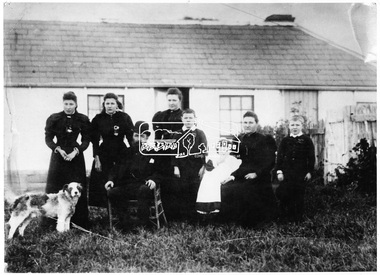
Photograph - Digital Image, View of Greensborough from Willis Vale, 1906_
View of Greensborough from Willis Vale. The people in the photograph were visitors and not identified. Willis Vale: House built by Edward Maygar, Robert Whatmough lived there mid 19th century and later sold to Partington family. It was located on the Plenty River at Partington's Flat Greensborough. Land use included farming and orchards. The derelict Willis Vale house was destroyed in 1964 when a fire originating from North Plenty Gorge - Kurrak Road - was lit by two teenage boys and made its way several kilometres down to Partington's Flat Greensborough. [Ellen died on 13/10/1903 - Some think this photo is thought to have been taken shortly after, at her funeral.]Digital copy of black and white photograph.willis vale, greensborough, partington family -
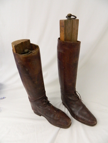 Kiewa Valley Historical Society
Boots Riding, late 1800's - early 1900's
The early Kiewa Valley farmers opened up the Bogong High Plains for cattle grazing in the late 1800's and early 1900's. Many farmers of the Kiewa Valley built huts on the Bogong High Plains to stay in during the summer mustering season. The Roper family had their own cattle run on the High Plains with several version's of Ropers Hut being built and used for this purpose. These boots were owned by Fred Roper whose father was one of the first pioneers of the Upper Kiewa Valley and Tawonga farming district. These boots were made around the late 1800's to early 1900's and are of a quality hide and a very good example of historical clothing worn at the time. These boots are very significant to the Kiewa Valley because the mark a period of early farming within the Kiewa Valley and Bogong High Plains as they were worn by Fred Roper who comes from one of the farming pioneering families of Tawonga. These boots were used when mustering the families cattle up to the Bogong High Plains for summer grazing and also around his farm in Tawonga when riding his horses. They were donated by his great grand daughter Leonie Roper in 2011, therefore the manufacturing of these boots could be anything from the late 1880's to early 1900's. They are made of high quality leather and were made to last the tough conditions of mustering and farming cattle. They also had wooden stock which fitted into them "KVHS 0445"These knee high "riding" boots have a 4 "rung" laces at the base of the upright boot and a strap at the top of the boot. They are made of brown leather and have a small heel (not the usual higher heel for stirrups)riding boots. footwear. cattle mustering footwear. roper family. cattlemen. bogong high plains. -
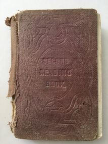 Warrnambool and District Historical Society Inc.
Book, Second Reading Book, 1876
This is a Reading Book of the Irish National Board of Education adapted for use in schools in Victoria, Australia. Irish School Readers were used in Victoria under the National School System in the 1850s and continued to be used in the 1860s and 70s under the Common School System and the introduction of the State School System after 1872. Readers produced in Victoria for Australian children did not become prominent until the 20th century (School Papers 1898 and Victorian Readers 1928). The signature of Hugh Adams in this book indicates that the book may have come from one of the Adams families farming in the Wangoom area near Warrnambool. There were several boys in these families named Hugh and it is unclear which one owned this book. This book is of interest as an early school reader used in the Warrnambool area and as a book belonging to a member of a local Adams family in the 19th century.This is a hard cover book of 285 pages. It has a brown cover with the title and ornamentation etched into the cover. The book contains prose extracts and poetry with the extracts headed by the derivation and pronunciation of some of the words in the text. There are a few illustrations and sketches. Some of the illustrations have been coloured and scribbled on. The book has been bound with string and glue with the lower portion of the spine cover missing. The book is very tattered. ‘Hugh Adams’ (back pages and on page 279) school readers, education in warrnambool, hugh adams -
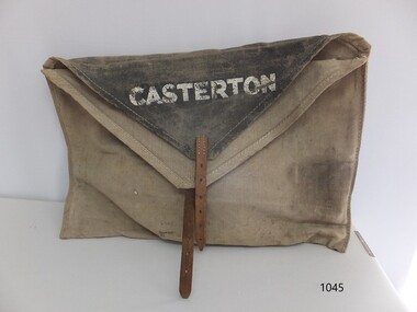 Flagstaff Hill Maritime Museum and Village
Functional object - Courier Bag, Government of Victoria, Late 19th to mid-20th centuries
The courier bag was once government property, as indicated by the broad arrow symbol. The flap has the name 'Boronia' - an area near Melbourne - overstamped with the town name 'Merino', and on the other side of the flap is the town 'Casterton'. Merino and Casterton are renowned for large sheep farming properties in Victoria's western district. Perhaps the courier bag was originally used between Melbourne and Boronia. During the late 19th and early-to-mid 20th centuries, a government-operated railway service was active in in the western district of Victoria. It served remote properties, including a line between Merino and Casterton. The train delivered mail, cash, supplies documents, business records and people between the sheep farm properties and the township of Casterton.This courier bag is an example of the connections and business between people in the remote areas of western Victoria. It was likely used by Victoria's railway system that transported people, goods, documents and cash between the districts of western Victoria.Courier bag; beige canvas rectangular bag with triangular black canvas flaps and a leather strap and buckle closure. The bag has stencilled stamps of three towns - Casterton, Merino and Boronia. It also has the government property symbol of a broad arrow.White stencilled paint "CASTERTON" Black stencilled paint "BORONIA" [barely visible] White over-stamped stencilled paint "MERINO"warrnambool, shipwreck coast, flagstaff hill, flagstaff hill maritime museum, flagstaff hill maritime village, bag, pouch, document pouch, courier bag, western district, western victoria, 19th century, 20th century, railway, rural business, rural trade, boronia, casterton, merino, sheep farm, sheep property, canvas bag, canvas courier bag, government courier bag, broad arrow -
 National Wool Museum
Archive - Report, Fred Moylan, The Wool Situation, 1970
Fred Moylan OAM born in Melbourne 1923, founded Moylan Woolen in 1950, at the beginning of an extended period of prosperity for the Australian wool industry. Moylan Woollens initial main focus was in the wholesale wool trade. In 1958-1959 the business diversified into angora farming and distribution. In 1967 the company merged with Debenhams Australia to form Debenham and Moylan Woollen Co Pty Ltd, later in 1980 the company was sold to Richard Allen. Moylan was a key business figure in the formation of the Australian Wool Bureau and Woolmark. He was awared the Member of the Order of Australia in 1997 for his contribution to the Australian and international wool industry. Source: Publication Moylan Woollens produced by the RMIT University Textile Resource Centre. Seven page single sided printed report with black typed text on cream paper.THE WOOL SITUATION 1970 / By F. H. MOYLAN B. Com. / Managing Director, / The Debenham & Moylan Woollen Co. / Pty. Ltd. / 153 Flinders Lane, / MELBOURNE. / 3000.frederick moylan, the debenham & moylan woollen co. pty. ltd, report, wool, industry -
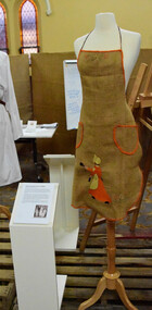 Ballarat Apron Festival
Apron, Sugar Bag Apron, 1930s
This apron was made by Theresa Dunn (néé Wallis) of Breakaway Creek, Victoria. Born in 1912, Theresa came from a farming family and left school at the age of 14 following the death of her mother to help care for her younger siblings. Well known for her needlework, Theresa and her sister Eileen exhibited widely and later judged work for Victorian and interstate needlework competitions. Sticklers for perfection, they were known to always look at the back of the work first. In 1935 Theresa married Allan Dunn. This apron formed part of her glory box; a collection of items saved in preparation for married life. Never used, it was donated to the Ballarat Apron Festival in 2017 by Theresa’s daughter. Made by Theresa Dunn of Breakaway Creek in the 1930s, this apron reflects early-20th century ideals of thrift and resourcefulness that were highly regarded as desirable feminine traits. By making do and adapting waste materials, such as hessian sacks and fabric scraps, into practical clothing, women could demonstrate their sewing expertise and ingenuity; highly prized qualities during times of economic depression or frugalness. Part of Theresa's glory box, this apron is in immaculate condition and is an example of depression era clothing and resourcefulness. Sugar bag apron (circa 1930s) Ballarat Apron Festival collection Until the mid-20th century concepts of thrift and resourcefulness were highly regarded as desirable feminine traits. By making do and adapting waste materials, such as hessian sacks and fabric scraps, into practical clothing, women could demonstrate their sewing expertise and ingenuity; highly prized qualities during times of economic depression or frugalness. Colonial Sugar Refining Co Ltd. Pure Cane Sugar 70lbs. Melbourne 1A -
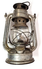 Wodonga & District Historical Society Inc
Domestic object - Kerosene Lantern
During the Victorian goldrushes of the 1850s thousands of Chinese migrants arrived to seek their fortunes. At that time many came to the lucrative gold fields of Northeast Victoria. After the Gold rush, many Chinese migrants returned home. However, a number settled in the area as merchants, hawkers and market gardeners in surrounding towns including Wodonga, the Ovens, King, Buffalo River and Kiewa Valleys. They also rented lands and established themselves in the hops and tobacco farming industries. Items of Chinese origin made their way into many households. Importation of Chinese mass produced items such as this lantern continued well into the 20th century and were common domestic items across Australia before households were connected to electricity.This item is representation of kerosene / paraffin lamps used throughout Australia to provide lighting inside and outdoors prior to the widespread availability of electricity.A small hurricane lamp with a rounded tank and small carry handle attached to the top. A larger handle is also attached at the top of the frame. It has a lever to open the glass tank. It has a metal base which is filled with kerosene. It has a screw knob to open the kerosene receptacle. The metal hood also has vents. The Chinese characters around the base translate to "Shanghai Guanghuaheng".Around base : Chinese characters. On top : "Made in China KWANG HWA"kerosene lamp, domestic appliances, chinese artefacts -
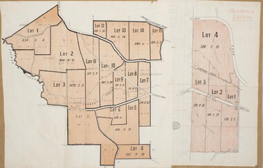 Bacchus Marsh & District Historical Society
Map, Glenvale Estate and Glenmore Estate Land Sales 1909
The two land auction plans shown in this record relate to the sale of land from the Glenmore Estate property. The Glenmore property was established by C.J. (Charles James) Griffith and James Moore around 1840. Moore sold his interest to Moelesworth Greene in 1848. Greene was the nephew of the other owner Charles Griffith who died in 1863. From around the 1870s onwards parts of the Estate were subdivided and put up for sale or lease. In subsequent decades more changes in ownership occurred. These two plans document another major sale of the land from the original Glenmore Estate including part of the estate which had become used for dairy farming and was at that time known as the Glenvale Estate. Two single page maps pasted together on a single page of a bound volume of maps. One map shows 15 separate lots of land for sale. The other map which has the words 'Glenvale Estate' at the top of the map shows 4 lots of land for sale. Both parcels of land were originally part of the Glenmore Estate a pastoral holding belonging to C.J. Griffith and James Moore which the began in the Rowsley area south west of Bacchus Marsh in the 1840s. The maps are pasted into a bound volume containing 76 maps or plans in total. High resolution digital image stored on BMDHS computer network. bacchus marsh victoria maps, glenvale estate property, glenvale estate land sales, glenmore estate, glenmore station -
 Orbost & District Historical Society
black and white photograph, April 17, 1897
This is the Nowa Nowa crossing off Old Orbost Road, to the first Nowa Nowa Hotel built by Moses Faithfull, in 1890, in background. Moses Faithful came to Australia from England with his parents on the Royal Consort in 1844. After living at Bulla, Pakenham and Wurruk he and his wife moved to Hospital Creek in about 1885 where he took up the first selection of land at Upper Hospital Creek. As well as farming he built the first hotel at Nowa Nowa in 1890. He had charge of the hotel until 1895 when he sold to Mary Stirling. Moses died on 8th July 1901, aged 66, at the residence of his son-in-law, David Price, at Newmerella, and buried in the Orbost cemetery.This hotel was built in 1890 and doubled as a coaching stop on the inland route. Settlement grew up around the hotel. It was sold 1895 to Mary Stirling who husband own the land the hotel stood on. The hotel burned down on 29 July 1955. This is a pictorial record of Nowa Nowa in the late 19th century.A black / white photograph of a creek crossing with large stones in the foreground. A bridge can be seen in the background across the creek.nowa-nowa faithful-moses stirling-hotel -
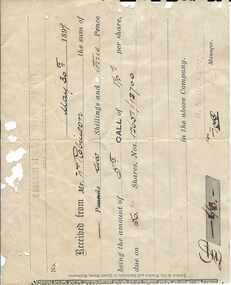 Warrnambool and District Historical Society Inc.
Financial record - Receipt: Grassmere Gold Mining Company, 1898
Grassmere is a small hamlet about 12 kilometres from Warrnambool. It is a farming area. The Grassmere Gold Mining Company, presumably established by local people in Grassmere, was created in 1898 for the purpose of acquiring from Messrs James and Mewha a lease of a Cassilis gold mine (23 acres). The Manager of the Company was Horatio Dickson of Melbourne and the brokers were McMeekin and Co. of Melbourne and Warrnambool and Dickson and Osborne of Melbourne. This reef mine was one of several in Cassilis, Gippsland, 12 kilometres north west of Swifts Creek. The gold-bearing quartz reefs were discovered in 1885 and worked to 1914. It is not known whether the Grassmere Cassilis mine was a financial success but the mining operations were impeded by the hardness of the stone in the area. William Robinson was a farmer in the Grasmere area. This receipt is of considerable interest as one of only three items the Warrnambool and District Historical Society that is connected to the establishment of the Grassmere Gold Mining Company. The gold mine establishment was one of the many minor events in the district in the 1890s. This is an 1899 receipt for William Robinson upon payment of six shillings and three pence, being part payment for shares in the Grassmere Gold Mining Company. The buff-coloured paper has black printing and black-ink handwriting. There are two stamps – one is the stamp of ‘H.S.Dickson’ and the other is the stamp of the ‘Grassmere Gold Mining Company, No Liability’. The certificate has silver fish damage at the top and the right-hand side‘May 30th 1899, Received from Mr Wm. Robinson the sum of six shillings and three pence, being the amount of 5th call of 1½ per share, due on 50 shares, nos. 12651/12700 in the above company, H.S. Dickson, Manager’grassmere, grassmere gold mining company, william robinson, warrnambool -
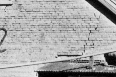 Greensborough Historical Society
Photograph - Digital Image, Brickwork, Willis Vale, 1950c
Close up photograph of a section of brickwork at Willis Vale. This is the end wall under the roof. Willis Vale built by Edward Maygar, Robert Whatmough lived there mid 19th century and later sold to Partington family. It was located on the Plenty River at Partington's Flat Greensborough. Land use included farming and orchards. The derelict Willis Vale house was vandalized in 1964 and destroyed when a fire originating from North Plenty Gorge - Kurrak Road - was lit by two teenage boys and made its way several kilometres down to Partington's Flat Greensborough. This photo was taken after the Partington's moved house in 1947 across the river where Alan built their new Alwyn house that had access to electricity.Part of Willis Vale, a pioneer home in the Greensborough area.Digital copy of black and white photograph.willis vale -
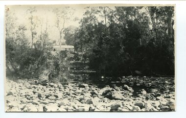
 Orbost & District Historical Society
black / white photograph, late 19th - early 29th century
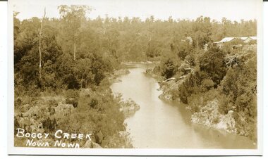
The building in this photograph of Boggy Creek is probably the first Nowa Nowa Hotel built by Moses Faithfull, in 1890. Moses Faithful came to Australia from England with his parents on the Royal Consort in 1844. After living at Bulla, Pakenham and Wurruk he and his wife moved to Hospital Creek in about 1885 where he took up the first selection of land at Upper Hospital Creek. As well as farming he built the first hotel at Nowa Nowa in 1890. He had charge of the hotel until 1895 when he sold to Mary Stirling. Moses died on 8th July 1901, aged 66, at the residence of his son-in-law, David Price, at Newmerella, and buried in the Orbost cemetery.This hotel was built in 1890 and doubled as a coaching stop on the inland route. Settlement grew up around the hotel. It was sold 1895 to Mary Stirling who husband own the land the hotel stood on. The hotel burned down on 29 July 1955. This is a pictorial record of Nowa Nowa in the late 19th century.A black / white photograph / postcard of a creek with a building on the rightside. a windmillis to the left. The banks of the creek are well-vegetated.on front - bottom left -"BOGGY CREEK NOWA NOWA"boggy-creek-nowa-nowa