Showing 1204 items
matching land for sale
-
 Kew Historical Society Inc
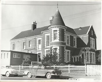
Photograph, Kew RSL, Cotham Road, circa 1965, c. 1965
The Kew RSL is located in "Wilton" House, 63 Cotham Road. The RSL was established on January 1st 1920, later joining with the Hawthorn RSL. In November 1931, Cr. C.R. Parry organised the reformation of the Kew Sub Branch and its first president was Brig-Gen Pat McGlin, a veteran of the Boer War and the First World War. On July 17th 1932, the club rooms first opened on Army land at the corner of High Street and Highbury Grove. In late November 1948, the Kew RSL bought the "Wilton" house from the Kew City Council for £10,067, opening seven years later in July 1955. [Source: Victorian Heritage Database]This work forms part of the collection assembled by the historian Dorothy Rogers, that was donated to the Kew Historical Society by her son John Rogers in 2015. The manuscripts, photographs, maps, and documents were sourced by her from both family and local collections or produced as references for her print publications. Many were directly used by Rogers in writing ‘Lovely Old Homes of Kew’ (1961) and 'A History of Kew' (1973), or the numerous articles on local history that she produced for suburban newspapers. Most of the photographs in the collection include detailed annotations in her hand. The Rogers Collection provides a comprehensive insight into the working habits of a historian in the 1960s and 1970s. Together it forms the largest privately-donated collection within the archives of the Kew Historical Society.The exterior of the Kew RSL on the corner of Cotham Road and Charles Street, Kew. Designed by Guyon Purchase for Dr. William Walsh in 1886, the building was originally called Wilton."Chap 59. Cotham Rd. Built/Commences about 1885-6. Present day Wilton . Kew RSSUILA rooms. (Rumour of sale 1972?)"wilton, dr william walsh, guyon purchas, dorothy rogers, cotham road (kew) -
 Whitehorse Historical Society Inc.
Article, Cole, George Henry (1859 - 1919), n.d
Article on George Henry Cole - Methodist minister born 7/12/1859 at Mickelham, Victoria, son of William Cole, a selector who arrived in Australia 1849. Ordained 1886, served at Sale, Murtoa, Eaglehawk, Armadale and Geelong. He was a minister of the Primitive Methodist Church. Methodist Union, 1902 enabled him to implement his brainchild, a boy's training farm and gave agricultural instruction to complement spiritual reformation and general education. A tour of New Zealand raised funds to purchase land for Tally Ho at Burwood. He was Superintendent 1904 - 1919. Died 1919. Buried Burwood Cemetary.cole, george henry, cole, william, cole, elizabeth, walton, w.h. (rev), cole, mary euphemia, primitive methodist church, lygon street, carlton methodist mission, tally ho boys home -
Whitehorse Historical Society Inc.
Article, Long medical history, n.d
Article and advertisement for sale of 331 - 335 Mitcham Road, Mitcham, home of Dr Threlkeld. It is part of the land purchased by Dr Francis Drake 75 years ago, he built a surgery and was involved with a private hospital on the next door site where Mitcham R.S.L. is now. He also conducted a sanatorium where Whitefriars is now. Between the wars Dr Stanley Cochrane built the home incorporated into a surgery in 1929. Dr Threlked continued the medical practice, erecting separate consulting rooms on the adjoining land to the site now being sold.threlkeld, verner w., dr, drake, francis john, dr, cochrane, stanley, dr, auctions, mitcham road, mitcham., drake & co. -
Whitehorse Historical Society Inc.
Newspaper - Article, 5 Longland Road, Heatherdale, 22/02/1984
Article in Nunawading Gazette re sale of 100 year old home at 5 Longland Road, Heatherdale. Double brick Victorian on bluestone foundations. Originally land was owned by Mr Witt who later became an M.P., later a master butcher. Mr Purches built the bluestone foundations. It was planned to have a village nearby to be called New Brunswick between Emery's Hill (now Mitcham) and what is now Ringwood. The only evidence of the once planned village is the existence of Brunswick Road nearby.longland road, mitcham, witt, william, purches (mr), brunswick road, mitcham, heatherdale, mitcham, emery's hill, real estate, auctions -
Whitehorse Historical Society Inc.
Newspaper - Article, 519 Mitcham Road, Vermont, 8/03/1989
Article in Nunawading Gazette re sale of early 1900s home at 519 Mitcham Road, Vermont. One of the original homes in the area. In the early days the land was primarily used as a poultry farm.mitcham road, vermont, real estate, auctions -
Whitehorse Historical Society Inc.
Document, Sale Plan 38, 12/09/1855
... Parish of Nunawading Sale Plan 38. Description of land... of Nunawading Sale Plan 38. Description of land is given with water ...Parish of Nunawading Sale Plan 38.Parish of Nunawading Sale Plan 38. Description of land is given with water supply. Surveyor C.Hodgkinson.Parish of Nunawading Sale Plan 38. parish of nunawading, hodgkinson, clement, water supply -
Whitehorse Historical Society Inc.
Document, Land Transfer, 1919
... Of sale of land Vol 4035 Folio 806811 to George Dodsworth... of sale of land Vol 4035 Folio 806811 to George Dodsworth 10 Jun... Patrick Joseph Markham to Commissioner of Taxes of sale of land ...Notice from Patrick Joseph Markham to Commissioner of Taxes.Notice from Patrick Joseph Markham to Commissioner of Taxes of sale of land Vol 4035 Folio 806811 to George Dodsworth 10 Jun 1919Notice from Patrick Joseph Markham to Commissioner of Taxes.markham, patrick joseph, dodsworth, george, whitehorse road mitcham -
Whitehorse Historical Society Inc.
Legal record - Land Title, Spall Orchard, 1916-1982
Certificates of Title relating to the Spall Orchard, Wattle Valley Road Mitcham and surrounding parts of Crown Portion 128, Parish of Nunawading.Certificates of Title relating to the Spall Orchard, Wattle Valley Road Mitcham and surrounding parts of Crown Portion 128, Parish of Nunawading. Principal landowners: Louis Schwerkolt (Vol.3955 Fol.825), Francis Arnold Vaughan and James George & Sybil Margaret Spall (Vol.8249 Fol. 849). With historical summary, agent's sale notice 1984 and letter from Shirley Mill.Certificates of Title relating to the Spall Orchard, Wattle Valley Road Mitcham and surrounding parts of Crown Portion 128, Parish of Nunawading.wattle valley road, mitcham, highland avenue mitcham, trenham court mitcham, spall, james george, spall, sybil margaret, vaughan, francis arnold, schwerkolt, louis, mill, shirley, land titles -
Whitehorse Historical Society Inc.
Article, Orchard estate land set to become townhouses, 2013
Report of sale of a 1.03 hectare property on cnr. of Junction and Surrey Roads Blackburn North.Report of sale of a 1.03 hectare property on cnr. of Junction and Surrey Roads Blackburn North, formerly part of an orchardReport of sale of a 1.03 hectare property on cnr. of Junction and Surrey Roads Blackburn North.surrey road, blackburn north nos. 59-67, cock, herbert, junction road, blackburn north, orchards -
Whitehorse Historical Society Inc.
Document, Property report, 1987
Property Report: Land at cnr. of Burwood Highway and Station Street BurwoodProperty Report: Land at cnr. of Burwood Highway and Station Street Burwood. For sale by tender on behalf of the Royal Victorian Institute for the Blind. Agent: Baillieu Knight Frank.Property Report: Land at cnr. of Burwood Highway and Station Street Burwoodburwood highway box hill south, station street box hill south, royal victorian institute for the blind, baillieu knight frank -
Whitehorse Historical Society Inc.
Correspondence, Documents re P.E. Eriksson property purchase, 1/03/1943
Invoice and receipt - property search for Mrs P.E. Eriksson from Flood & Permezel solicitors, Collins Street. Receipt for deposit from Frank Parker, Real Estate Agent. Title check and plan from Flood & Permezel. Copy, contract of sale - Insurance Policy Coop Insurance Co. Invoice Griffiths Bros, tea merchants Nov 1910 - Jan 1911 for Mrs A. Eriksson. Advice - certificate of title.eriksson, pearl eileen, w. h. flood & permezel, frank parker (real estate agent), warnes road, mitcham no 30, land sales, cooperative insurance company of australia, edgar -
Whitehorse Historical Society Inc.
Document, Robert Collier Land, 1903
... and receipt from Maddock & Jamison for services relating to above sale... to above sale and to purchase of land in Tunstall from Freehold... to above sale and to purchase of land in Tunstall from Freehold ...50 acres and house in Canterbury Road Blackburn to I.N. Cuttle for (pounds)590Papers relating to land dealings by Robert Collier of Springvale Road Tunstall. 50 acres and house in Canterbury Road Blackburn to I.N. Cuttle for (pounds)590collier, robert, t.r.b morton & coghill, maddock & jamison, canterbury road blackburn, freehold investment company of australia ltd -
Whitehorse Historical Society Inc.
Document, Kaufmans Road, 1896
... Documents and contracts about the sale of land bounded... and contracts about the sale of land bounded by Kaufmans, Canterbury ...Documents and contracts about the sale of land bounded by Kaufmans, Canterbury and Bakers Roads Blackburn, 1896.Documents and contracts about the sale of land bounded by Kaufmans, Canterbury and Bakers Roads Blackburn, 1896.Documents and contracts about the sale of land bounded by Kaufmans, Canterbury and Bakers Roads Blackburn, 1896.canterbury road blackburn, bakers road blackburn, schwab, henri samuel, morton, thomas richards burrowes, land sales, kaufmans road blackburn -
 Orbost & District Historical Society
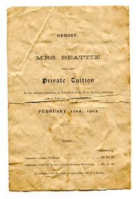
advertisement, 1902
Mrs Arthurena Dora Beattie (nee Morrison), had been teaching privately at Rosedale and came to Orbost with her husband and family in 1890. In 1892 she opened a private school in Salisbury Street (about the site of the Countryman Motor Inn) which she conducted for about 10 to 12 years. Her husband, John Wilson Beattie, a retired State School teacher, had been head teacher at the Rosedale School from July 1870 to August 1884. After coming to Orbost he selected land on Wall Creek. He was a widower with 7 of 11 surviving children when he married Arthurena in 1885. His fist wife, Georgina (nee KELLY) died at Rosedale in 1883 when the youngest child was just 5 weeks old. John and Arthurena had a further 8 children (5 born at Orbost), and after John's death she married George McCARLIE in 1916 at Sale and moved Mirboo North. (references:BEATTIE, Arthurena Dora Music teacher, Orbost - 1903 Electoral Roll. BEATTIE, Arthurena Dora Teacher, Orbost - 1912 Electoral Roll.) There was at least one other private school much earlier, in 1884. It was thought to be the first school in the district and conducted by William Ballantyne. It was located on the flat on the Newmerella side of the Snowy River near where the first railway crossing used to be. Wm Ballantyne had previously taught school at Sarsfield from June 1873 to November 1879. (information from John Phillips) This advertisement was for educational tuition by Mrs Beattie. Tuition would be from 10.00am - 12.00 and from 1.30pm - 3.30pm. Costs were thirteen shillings per quarter for children under the age of 12 years and one guinea for those over 12 years. A reduction would be given for more than one child in the same family. The 1872 legislation required all children aged 6-15 years to attend school unless they had a reasonable excuse. Parents who did not send their children to school were liable for fines up to five shillings for a first offence, with the penalty increasing to 20 shillings for each repeat offence. The Orbost State School had opened on 19th of March 1886 and this "private school" appears to have been a small private enterprise school. This is a useful research item associated with education in Orbost.A white A5 size paper advertisement which has black print. It is an advertisement for private educational tuition. Details of costs and hours are included.beattie education school advertising -
 Orbost & District Historical Society
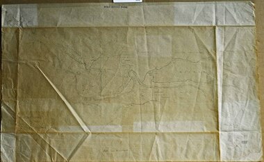
survey sheet, circa 1870's
E.L. Bruce, born in Ireland on July 1,1854, came to Australia in 1854 and joined the Lands Department. He spent most of his service in Gippsland. The journey to Sale then was made by ship to Port Albert and thence on horseback. He began his service in Gippsland as assistant district surveyor and for the last 12 years before retirement he was district surveyor and land officer. His territory extended from the boundary of Victoria in east Gippsland down to Wilson's Promontory with his headquarters at sale.This map is a useful reference tool.A survey map - Sheet No 3 SnowyRiver Survey. This is a copy of the original survey. It shows the properties of W.J.T. Clarke - two in Orbost and one in Newmeralla (sic),. it has a faded, undecipherable red stamp in the bottom right corner.Gipps Land Rivers No 32B E.L. Brucesurvey bruce-e.l snowy-river-c19th -
Warrnambool and District Historical Society Inc.
Document, Wollaston sale, 1919
This is a poster advertising the sale of part of the Wollaston Estate in Warrnambool in 1919. The sections for sale were Allotments 1, 18 and 19 which included the Wollaston Homestead. The original Wollaston property of 679 acres was selected by Thomas Manifold in the late 1840s. This land, on the northern side of the Merri River, near the Woodford Road was three kilometres from the Warrnambool town. The first farmer we know who leased the property was William Simpson. Walter Manifold inherited the property and he took it over in 1884. The swing bridge he built in 1890 still stands today. In 1919 the Closer Settlement Board of Victoria acquired Wollaston and 17 lots were sold to returned soldiers for farming purposes. By 1930 there were only five soldier settlers remaining. In 2009 further subdivision took place with lots sold for residential purposes. The homestead allotments were sold separately in 1919 with various owners of the homestead itself recorded since that time. This poster is of interest as it shows the areas of the Wollaston Estate which were sold in 1919. The history of this estate is well-documented and of importance in the history of Warrnambool. This is a sheet of paper with red and black printing and a map of the Wollaston Estate which is photo-lithographed. The sheet has been folded three times. It has some small tears at the top of the page. wollaston, history of warrnambool, walter manifold -
 Warrnambool and District Historical Society Inc.
Book, The Domestic liturgy & family chaplain, 1846
This book belonged to John Cowtan. He was a purchaser of land near Cassady’s Bridge in Warrnambool and an important and early settler in Port Fairy. The land that John Cowtan selected was bought by Williaam Cassady whose sister, Ann, was married to John Cowtan. Cassady established the property, Boughton where Cassady’s Bridge is today. This book came from a Cassady estate sale early in the 21st century. Between 1839 and 1844 John Cowtan was a ship’s captain for John Griffiths, a shipowner and entrepreneur. In 1844 Cowtan established a merchant trading and produce business in Port Fairy with John Bland. In the 1860 John Cowtan went to live in Melbourne.This book is of great interest because of its early date (one year after the founding of Warrnambool) and because of its association with John Cowtan, a pioneer settler of Port Fairy with connections to Warrnambool.This is a brown leather cover book of 385 pages. The spine has gold lettering. The binding has come apart and has been mended with white cotton material on the inside of the cover. The insides of the cover have a brown, white, blue and yellow mottled pattern. The cover is stained and torn at the edges and has a deep gouging on the front. The first page has been torn and mended with tape and some of the pages are stained. There are two pressed fern fronds, one loose newspaper cutting and a bookmark with a sepia-coloured image, lace paper edges and coloured embroidery contained within the pages. The book has a preface and 58 chapters. The inscription is handwritten in black ink. ‘J. Cowtan 1848’ john cowtan, port fairy history, william cassady -
 Warrnambool and District Historical Society Inc.
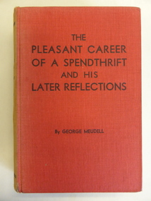
Book, The Pleasant Career of a Spendthrift and his Later Reflections, 1929
This book is an autobiography of George Meudell (1860-1936). He spent about six years in Warrnambool as a young boy when his father came to Warrnambool as the Manager of the Bank of Victoria. Meudell went to the Warrnambool Common School 646. He later became well-known in Melbourne in social, economic and political affairs. He was a company promoter, stockbroker and writer and an acquaintance of most of the influential and wealthy people of the time. In 1928 Meudell wrote an article for the Royal Historical Society of Victoria Journal detailing his memories of Warrnambool and this article is now a very important piece of local social history. He was enthusiastic about the benefits of living in Warrnambool in the 1860s and 70s. Meudell’s book, ‘The Pleasant Career of a Spendthrift, was an important publication as it gave a complete account of the commercial morality of the power brokers in the financial world - those concerned with the land boom and the banks’ crash of 1886-1893. The book was so inflammatory that it was initially withdrawn from sale. This book is of considerable interest as it was written by George Meudell who lived in Warrnambool in the 1860s and 70s and played a part in Warrnambool’s history by writing about these years. The book is also of wider interest as it has some information on people connected with Warrnambool’s history, including John Archibald and Thomas Bent. The signature in the front of the book is of no known relevance to Warrnambool.This is a hard cover book of 282 pages. The cover is red with black printing and the spine is very faded. The book has a foreword and twelve chapters of text. The first page contains a signature and notes written in pencil.‘Gordon Leitch Christmas 1942’ george meudell, victoria’s land boom (19th century), history of warrnambool -
 Warrnambool and District Historical Society Inc.
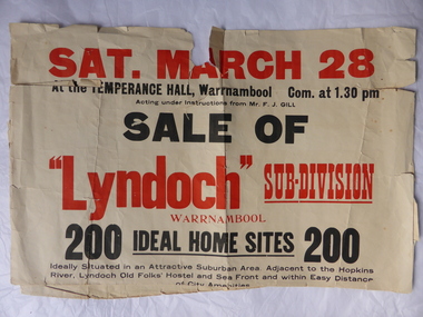
Poster, Lyndoch Sub-Division
This is a poster advertising the sale of the Lyndoch sub-division in Warrnambool with the sale of 200 housing sites. The sale took place about 1958 with the land sold by Frederick Gill, a Warrnambool jeweller. The land was previously owned by George Rolfe who had acquired the land near the mouth of the Hopkins River in the 1880s and named the property ‘Lyndoch’. He bought the surrounding land at a later time. This sub-division came to be known as the Gill Estate. It was a valuable site as many of the allotments fronted the sea and others were adjacent to the Hopkins River. This poster, although tattered, is of interest as it has many details of the Gill Estate sub-division and will be useful to researchers. This is a cream-coloured paper poster with black and red printing. The poster has a small map in a circle shape showing the location of the streets and a larger map section showing the streets and the allotments to be sold. The poster is in two pieces and the edges are torn and, in some sections, missing. The streets map has some pencil annotations. history of warrnambool, lyndoch, warrnambool, george rolfe, frederick gill -
 Warrnambool and District Historical Society Inc.
Documents, Swintons Paper att 18/53 Merri St. Contract. Map. Notes, 1959
... These documents relate to the sale of land in Merri Street...The items here relate to the sale of land by Swintons Pty... here relate to the sale of land by Swintons Pty Ltd ...These documents relate to the sale of land in Merri Street Warrnambool in 1959 by Swintons Pty Ltd of Warrnambool. The buyer of the land was George O’Grady, a Warrnambool baker. The land sold for £4000 and there was a shed on the land (called the ‘Office’) which George O’Grady indicated he wished to be included in the sale. William and Ann Swinton migrated to Australia in 1854 and for a decade William Swinton worked as a builder and carpenter in the Warrnambool area, erecting many buildings, including the Wangoom Presbyterian Church. In 1865 he opened a store in Timor Street Warrnambool, selling groceries, hardware, china and glassware. By 1888 the business was known as William Swinton and Sons. Branch stores were opened in Wangoom, Cudgee, Nullawarre, South Warrnambool and West Warrnambool. After William Swinton died his son Robert became the first managing director of Swintons Pty Ltd. In 1934 the business split with George Swinton and Sons selling clothing, furnishings and glassware and Swintons Pty Ltd selling seeds, produce and hardware. Today the Swinton family still operates a furniture and bedding shop in Timor St Warrnambool.These items are of some interest as being connected to the Warrnambool business of Swintons Pty Ltd. They will be of interest to researchers. The current Swinton business in Timor Street is the oldest family business in Warrnambool and, with the name Swinton associated with businesses in Timor Street Warrnambool for 152 years it is amongst the oldest family businesses in Australia.The items here relate to the sale of land by Swintons Pty Ltd., Warrnambool. .1 These are three pages of white paper with typed material, a lawyer’s signature in blue ink, one green stamp and a sketch of the land location. .2 This is a sheet of thick paper containing a plan of the land sold. The paper has printed material and a sketch of the land with part of it coloured in pink. .3 This is a small piece of paper torn at the bottom right edge. It has handwritten material (a letter) in blue ink..2 ‘Plan of Survey of Part of Crown Allotment 18 Section 3 Township of .2 ‘Plan of Survey of Part of Crown Allotment 18 Section 3 Township of Warrnambool Parish of Wangoom County of Villiers’ .3 ‘Tuesday Dear Mr Swinton I am writing to say that I would like to have the ‘Office’ Thanking You George O’Grady’swinton family,, warrnambool -
 Warrnambool and District Historical Society Inc.
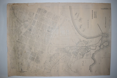
Documents Maps (3) - Warrnambool Town Allotments, City of W'bool Parish of Wangoom Country of Villiers, 1948
These maps were produced in 1948 and they contain maps of allotments within the city of Warrnambool, including the Central Business District, up to 1948. The details given on each allotment show the allotment and section numbers, the measurement in acres, the name of the original purchaser of the lot and the date of the first sale. The Warrnambool and District Historical Society owns several copies of these maps but these ones are originals.These three maps are of great significance because they give the names of land purchasers in Warrnambool from the date of the first land sales in 1847. They are a most valuable research tool and can be scanned and photocopied etc.These are three sheets of cream paper pasted on to linen. The sheets have black and white printing and map work. Some of the edges are a little frayed and there is some staining, particularly on the backs of the sheets.‘City of Warrnambool Parish of Wangoom County of Villiers Sheet 1’ ‘City of Warrnambool Parish of Wangoom County of Villiers Sheet 2’ ‘City of Warrnambool Parish of Wangoom County of Villiers Sheet 3’city of warrnambool, warrnambool maps, warrnambool town allotments 1948, land purchases -
 Warrnambool and District Historical Society Inc.
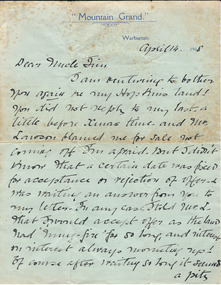
Document, Docket RF Kennedy, Letter written - 1908
This letter written by Mary Adams concerns the sale of a property, ‘my Hopkins land’, perhaps in the Warrnambool area. No information is available on Mary Adams or her ‘Uncle Jim’. There is a reference in the letter to ‘Mr Lawson’ and this may refer to a member of the Lawson family living in Warrnambool about this time, perhaps Richard Lawson who, in 1908, was Principal of a private school, Warrnambool College Academy. The Mountain Grand Guest House in Warburton was a well-known guest house in Victoria for many years and was still in existence in 1948. The letter came to the Society’s collection with other material relating to the Warrnambool Club. As no enlightening information is available on this letter or its contents it is of little importance at this time. Further research may render it a useful item to keep. This is a letter of two pages written in 1908 by Mary Adams to her Uncle Jim. The letter is handwritten in black ink. The letter is written on the green notepaper of the Mountain Grand Guest House Warburton, Victoria‘Mountain Grand, Warburton’ (on letterhead)mary adams -
 Warrnambool and District Historical Society Inc.
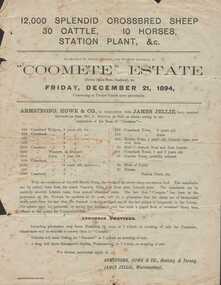
Advertisement, Coomete estate, Sale of stock and plant, 1894
Augustus Bostock was the 9th child of Robert & Rachael Bostock of Vaucluse Epping Forest, Van Diemen’s Land. He was only 4 years old when his mother died. He was inspired by his father to seek his fortune in the Western District of Victoria. He arrived around 1850. He married Margaret Aitkin in July 1865. Augustus owned several properties in the district and leased others. He sat on the court of Warrnambool, Mortlake or Hexham as required. He resided at Marramook in Hawkesdale and later moved to Vaucluse in Hopetoun Road Warrnambool, where he died in 1920 at the age of 87. He was involved in many aspects of life in the Western District, racing, cricket, and social activities to name a few. This flyer is advertising the sale of 12000 sheep, 30 cattle, 10 horses and station plant at the expiration of the lease of Coomete. It states that Coomete has been in the possession of Mr. Augustus Bostock for over 30 yearsThis is one of a number of documents which relate to the Bostock family who were one of the most important pioneering families of the Western District. They owned and leased various properties around Warrnambool and were involved in many aspects of social and business life. This document contains a detailed view of the stock owned by Augustus Bostock at Coomete. From a social perspective the details provided show that it was an event of some importance in the farming area.Cream paper with heading and title in large font at the top with Coomete Estate in uppercase inside banner lines underneath with details of stock and numbers to be sold in smaller print below. Mercer printer Geelong. For further particulars apply to Armstrong, Howe & Co Geelong and Terang, James Jellie Warrnambool.warrnambool, augustus bostock, coomete, coomete lease 1894,expiration of lease, of coomete, -
 Eltham District Historical Society Inc
Audio Recording, Audio Recording; 2018-06-13 Jim Connor and the history of the former Shire of Eltham office site, 13 Jun 2018
June Meeting (Newsletter No. 240, Jun. 2018) Prior to Shillinglaw Cottage (c1878-80) being relocated to where it is now operated as a popular cafe near the Eltham Library, it was within Josiah Holloway’s 1850s subdivision known as Little Eltham, which later became the centre of the first Eltham township. Originally a farmer’s cottage it is historically significant because it is one of the Shire’s oldest dwellings and a fine example of the work of the well-known pioneer builder George Stebbing. In 1964 the then Shire of Eltham purchased the Shillinglaw property with the intention of demolishing the cottage and constructing new Shire offices on the site. However extensive community action resulted in funds being raised to have the building saved and relocated further south to the Eltham Common, where it was joined by the Eltham Library 1994. New Shire offices opened in 1965, but following municipal restructure in 1994 these were demolished and the land sold to a developer, which precipitated a dramatic trail of community angst, threats of legal action, the sacking of a newly elected council and several unsuccessful development proposals, by subsequent councils. After all these years the vacant site there is still guarded by the three trees that were outside the front of the Shillinglaw Cottage. At our Society meeting on Wednesday 13th June 2018 Jim Connor will speak about the dramatic tale encompassing the history of the former Eltham Shire office site and the adjoining War Memorial Buildings complex, which are now being considered for sale or redevelopment by the current Nillumbik Shire Council.1:17:57 duration Digital MP3 File 27 MB audio recording, eltham district historical society, jim connor, meeting, shire of eltham office site, society meeting -
 Eltham District Historical Society Inc
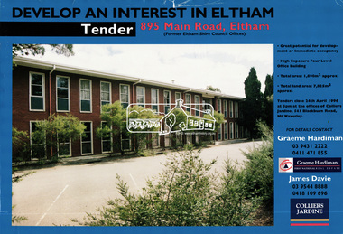
Document, Tender Documents for purchase of Former Eltham Shire Offices 895 Main Road, Eltham, April 1996, 1996
Graeme Hardiman Real Estate Prepared for Nillumbik Shire Council Maddock Lonie & Chisholm, 140 William Street, Melbourne Tenders closed at 3.00pm on 24 April 1996 Whilst the sale of the former Shire Office site went through and the Shire Commissioners approved the demolition of the building several months later in the year, ongoing community protests and objections eventually led to the reversal of the sale. Despite several further attempts to sell the site and community protests as recent as 2019, the vacant land remains in Council ownership.89 A4 pages; 1 x glossy paper with photo and 88 x photocopied pageseltham shire office, graeme hardiman first national real estate, maddock lonie & chisholm, nillumbik shire council, real estate, tenders -
 Eltham District Historical Society Inc
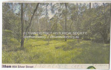
Document - Property Binder, 30 Kerrie Crescent, Eltham
Folder of information including: 1. Newspaper clipping of Real Estate adverisement for 85A Silver Street showing undeveloped land written underneath in pencil "30 Kerrie Cres Eltham". 2. Site Plan and Contours including structure scheme: Proposed residence for Janet R Boddy at Lot 3 Kerrie Crescent, Eltham, 25-9-72 (2 copies). 3. Handwritten notes (on the back of recycled paper for Paul/Boddy Gold Coast Studio offering painting tution in Surfers Paradise) by Janet Boddy to Ivan Stranger designed the house (3 pages). 4. Handwitten notes addressed to Mr L. Nelson, Greensborough requesting faults in the causeway at the Boddy property to be fixed signed possibly by Ivan Stranger (2 pages). 5. Hand drawn profile of a house. 6. Copy of a refined profileof the house as above. 7. Information sheet published by the Shire of Eltham; "General information to propspective builders in the Shire of Eltham" outlining obligations under the town and country planning control. 8. Printouts of a series of photographs and plan of the house, also replicated in Morrison Kleeman brochure, 2022 (3 pages). 9. Colour brochure produced by local Real Estate Agent promoting the sale of 30 Kerrie Crescent, Eltham.Folder of information including: 1. Newspaper clipping of Real Estate adverisement for 85A Silver Street showing undeveloped land written underneath in pencil "30 Kerrie Cres Eltham". 2. Site Plan and Contours including structure scheme: Proposed residence for Janet R Boddy at Lot 3 Kerrie Crescent, Eltham, 25-9-72 (2 copies). 3. Handwritten notes (on the back of recycled paper for Paul/Boddy Gold Coast Studio offering painting tution in Surfers Paradise) by Janet Boddy to Ivan Stranger designed the house (3 pages). 4. Handwitten notes addressed to Mr L. Nelson, Greensborough requesting faults in the causeway at the Boddy property to be fixed signed possibly by Ivan Stranger (2 pages). 5. Hand drawn profile of a house. 6. Copy of a refined profileof the house as above. 7. Information sheet published by the Shire of Eltham; "General information to propspective builders in the Shire of Eltham" outlining obligations under the town and country planning control. 8. Printouts of a series of photographs and plan of the house, also replicated in Morrison Kleeman brochure, 2022 (3 pages). 9. Colour brochure produced by local Real Estate Agent promoting the sale of 30 Kerrie Crescent, Eltham. kerrie crescent, mud brick building, ivan stranger, alistair knox design -
 Eltham District Historical Society Inc
Document, Samantha Westbrooke Pty Ltd et al, 2 Bell Street, Eltham: Cultural Heritage Significance Assessment & Heritage Guidelines for Future Use & Development, 2012
Prepared for Nillumbik Shire Council by Samantha Westbrooke Pty Ltd in association with Peter Mills PhD, Architectural Historian and Roark Muhlen-Schilte, Archaeologist. Covers history of early market gardening in Eltham with the commencement of European settlement in the late 1830s. The site for the village of Eltham was surveyed in 1851 and the Township Plan shows that the property is made up of Lots 7 and 8 which were sold at auction in June 1852 to M. O'Shea. The history of the Bell Street property is closely tied to the West family from the 1860s to 1930s; the earliest rate books for Eltham show William West farming in El;tham in 1864. In the aerly 1930s ownership of the creek side was transferred from the west family to the Fabbro family who shortly afterwards were impaced by the 1934 Diamond Creek flooding. Guido Fabbro relocated the original West home further up the hill and built a new Italianate style modern home in situ. The Fabbro family farmed the property. In 1993/4 Eltham Council acquired the creek-side market garden blocks to the south of 2 Bell Street which was recconceived in 1998 as the Barak Bushland Reserve. The Fabbro house was demolished shortly after and the lots were sold to a developer in 1994. The large steel shed now present on the 2 Bell Street property dates from soon after this sale.26 A4 pages color printcultural heritage significance assessment, peter mills, samantha westbrooke pty ltd, shire of nillumbik, 2 bell street, eltham, market gardening, west family, fabbro family, land use, barak bushland reserve, heritage assessment -
 Otway Districts Historical Society
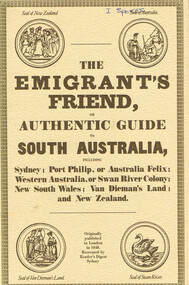
Book, Reader's Digest Services Pty Limited, The emigrant's friend, or authentic guide to South Australia, 1974
This book is a replica of a booklet printed in the United Kingdom. In 1848, when it was published in London as a guide to prospective emigrants, 23,904 people left the United Kingdom for the Australian colonies and New Zealand. In 1847, with the failure of potato crops threatening famine in Ireland and growing political unrest at home, the British Government had once again encouraged emigration by offering free passage to candidates of 'good character'. Immigration, particularly by the labouring classes, was intended to relieve both the overburdened Mother Country and the colonies which had acute labour shortages. The booklet gives some history of each colony as well as the sale of lands, mines and mining, produce, the price of living, wages and, generally, the situation. The emigrant's friend, or authentic guide to South Australia including Sydney: Port Phillip, or Australia Felix: Western Australia, or Swan River Colony: New South Wales: Van Dieman's Land: and New Zealand. Reprint. Reader's Digest Services Pty Limited; Surrey Hills (NSW); 1974. 40 p. Soft cover. australia; colonies; settlement; nsw; port phillip; western australia; south australia; van dieman's land; new zealand; emigration; immigration; -
 Otway Districts Historical Society
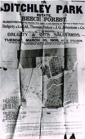
Photograph, Knox Collection, Sale of the Ditchley Park Estate, Beech Forest, 1908
... beech forest; ditchley park; land sale; advertisment;...; land sale; advertisment; Knox Collection ...Commercial realities and bushfires caused the Beech Forest community to re-establish itself around the railway station, away from Gardner Hill. This caused John W. Gardner to subdivide his land on the north side of the railway station. One subdivision was created near the Ditchley railway station on the old racecourse site, and another of 25 allotments forming what became Southorn Street. There were very few takers for these lots nor any buyers for the Ditchley subdivision.Photocopy. 260mm x 159mm. An advertisement for the sale of the Ditchley Park Estate, Beech Forest. Under instructions from Mr. J.W. Gardner Dalgety & Co. Ltd. will sell the subdivision of the Ditchley Park Estate on Tuesday, March 30, 1909, at 2 o'clock. A map of Beech Forest township and the Ditchley Park Estate is attached, as are the terms of sale and a description of the area.. beech forest; ditchley park; land sale; advertisment; -
 Eltham District Historical Society Inc
Photograph, Hans Gregory, Original 1860s William West house, Fabbro's Farm, Falkiner Street, Eltham, c.1990
Photos taken by Hans Gregory who along with partner Pauline Steele, rented the original old 1860s William West Cottage situated behind the Fabbro family home. Hans was employed as a Youth officer with the Shire of Eltham at the time and was the last tennant on the property. The property was sold and in 1995 was developed for residential housing as the Riverview Park estate. Guido Quarto Fabbro was born 21 August 1891 at Treppo Grande in the far northeast of Italy, the son of Giacomo Fabbro and Anna Geruzzi. Regina Moretti was born 6 March 1893 at Treppo Grande, Italy, the daughter of Giovanni Battista Moretti and Maria Teresa Coletti. Guido and Regina married about 1917 and they had two sons, Giacomo (John c.1918) and Maurie (c.1920). In 1925 Guido Fabbro departed his homeland from Genoa, arriving in Fremantle, Western Australia in June, travelling 3rd class aboard the ship, Caprera. Regina and their two boys followed a year later along with other family members arriving in Fremantle from Genoa 4 July 1926 aboard the Moncalieri. The Fabbros arrived in Eltham in 1933 and purchased a block of land from William West on the western side of Falkiner Street, extending to Ely and Porter Streets which had formerly been part of the West family orchard and dairy farm. As there was no fencing dividing the two properties, West served notice on Guido in December 1934 to bear half of the cost of £6. When payment was not forthcoming, West sued Guido in the Eltham Court in January 1935. Guido failed to appear and was not represented, and costs were ordered in West’s favour. Guido and Regina built a large Italianesque house on their property. The original 1860s cottage was relocated to the back of the block and was rented out (once to Alistair and Margot Knox). Guido also purchased land extending to the Diamond Creek on the eastern side of Falkiner Street and on the eastern side of Bell Street (opposite Eltham High School). The riparian soil was suitable for market gardening: Guido grew mainly tomatoes, but also pumpkins, cauliflowers, cabbages, peas, beans, lettuce, beetroot and zucchinis. Even the land surrounding the house was used. The produce was carted to Melbourne overnight for sale at the market. Guido died in 1970 and is buried in Eltham cemetery. Regina died 1986. She and their son John Patrick (Giacomo) Fabbro who died in 1984 are also buried at Eltham Cemetery. Guido’s son Maurie continued in his father’s footsteps until 2007, principally growing artichokes in later years. He died in 2009. The land on the eastern side of Falkiner Street now forms part of a Council reserve called “Barak Bushland”, the land on the western side having been sold off for residential subdivision. The Bell Street land is now public open space managed by Nillumbik Shire Council and called “Fabbro Fields”. There have been recent proposals to develop the site for sporting purposes or as a dog park or community garden. Provides an insight into early settler's farmhouses and farming property of the Eltham district.guido quarto fabbro, regina fabbro (nee moretti), william west, maurie fabbro, fabbro's farm, hans gregory, west family orchard, west dairy farm