Showing 157022 items
matching melbourne-exhibition
-
 Queen Victoria Women's Centre
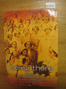
Book, Susan Sherson, Being There: Nursing at "The Melbourne" Victoria's First Hospital, 2005
It follows the intertwined history of nursing and the Royal Melbourne Hospital. Significant events, people and places. 572 pages. Orange toned cover of nurses c.1934 with handwriting overlay. White pages with black and white images throughout. Added Index booklet 32 pages attached. inside the cover handwritten inscription from the author in blue ink reads "For the Queen Vic Women's Centre, Warmest good wishes, Susan Sherson 7/2/2008"women health professionals, historic buildings, hospitals -
 Inverloch Historical Society
004331 - Photographs - 2nd June 2017 - Inverloch Historical Society Exhibition Opening - Community Hub
51 Digital photographs taken at the opening of the Inverloch Historical Society Exhibition in June 2017. The opening was at 2pm on Saturday 2nd of June 2017. Location: Inverloch Community Hub. Speakers: Introduction & conclusion: Graham Paterson (Secretary) Master of Ceremonies: Pamela Rothfield (Bass Coast Shire Council Mayor) Speaker: Eulalie Brewster (Patron) Speaker: John Hutchinson (President) Exhibition launch by: Brian Paynter (Member of Victorian Parliament - Member for Bass) Also in attendance Jullian Brown (Bass Coast Shire Councillor for Bunurong Ward) -
 Bendigo Historical Society Inc.
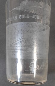
Memorabilia - Victorian Gold Jubilee Glass
The Victorian Gold Jubilee Exhibition, held at Bendigo from 13 November 1901 to 14 May 1902. The courts were numbered from one, or had titles like “Machinery”, “Agricultural”, “Naval & Military Court” and “Art”. The female visitors to the Exhibition were able to view exhibits deemed suitable for the fairer sex and located within their own “Women’s Court”. There were exhibits such as “Parasols & Umbrellas”, cotton and haberdashery from Manchester and Staffordshire, “Corsets & Embroideries” from Paris. The most valuable exhibits were mining machinery such as Taylor Horsfield’s £850 “Air Compressor & Rock Borer”. “Bohemian Glassware” brought down from Sydney was valued at £600. The profits from this Exhibition were used to fund the sculpture known as the Gold Monument, which still gazes along Pall Mall (from the McCrae Street end). The Exhibition’s Cash Book shows payments, which totalled £1160, were made to then up and coming sculptor C.D.Richardson. Recently a City of Greater Bendigo staff member used both these volumes to write a detailed report about this monument, for Heritage Victoria.Etched Drinking Glass to commemorate Victorian Gold Jubilee Exhibition Bendigo 1901-2 Decorated with a scene of Bendigo and fern fronds.Victorian Gold Jubilee Exhibition Bendigo 1901-2 Jack Gordonvictorian gold jubilee exhibition bendigo, 1901-2, jack gordon, bendigo -
 Slovenian Association Melbourne
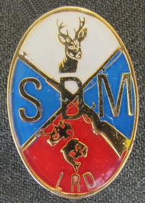
Hunters and Anglers badge, Slovenian Association Melbourne Hunters and Anglers badge
Slovenian Association Melbourne - Hunters and Anglers badge was worn by the group members at competitions and parades.SDM - Slovensko društvo Melbourne Slovenian Association Melbourne LRD - Lovska ribiška družina - Hunters and Anglersbadge, slovenian association melbourne, hunters and anglers -
 Flagstaff Hill Maritime Museum and Village
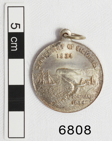
Medal - Commemorative, Centenary of Victoria, Melbourne and Portland, 1935
This commemorative medal celebrates a colonisation of two towns, now cities, in Victoria; Melbourne and Portland. The medal shows the significance placed on the colonisation of Victoria and the growth of the hundred year period. Medal, silver. with hole and ring at the top. Obverse: Sailing Ship, Coast, Boat on shore, 3 men. Reverse Colonial man on grass, river, city buildings on other river bank Medal commemorates the centenary of Victoria and Portland 1834 and Melbourne 1835. "CENTENARY OF VICTORIA 1934" & "PORTLAND 1834", "CENTENARY OF MELBOURNE 1935" & "1835" flagstaff hill, warrnambool, shipwrecked-coast, flagstaff-hill, flagstaff-hill-maritime-museum, maritime-museum, shipwreck-coast, flagstaff-hill-maritime-village, medal, centenary medal, centenary of victoria, centenary of melbourne, 1834-1934, 1835-1935, colonial, centenary of portland, colonisation of victoria -
 Ballarat Heritage Services
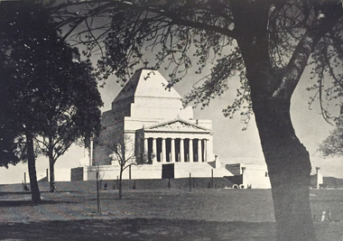
Photograph - Image, Shrine of Remembrance, Melbourne, c1934, 1934
The design for the Shrine of Remembrance was selected by competition among Australian artists and architects. Eighty-three designs were submitted and the winning design was by two Melbourne returned-soldier architects, Philip Hudson and James Wardrop. The inspiration for the external outline came from one of the seven wonders of the ancient world—the mausoleum at Halicarnassus to Mausolus, King of Caria in South West Asia Minor. Although the country was faced with frightful unemployment and financial difficulty in the late 1920s and the 1930s, so great was the gratitude of the people that the huge amount required to build the Shrine was raised or promised within six months from the opening of the appeal in 1928. (https://www.shrine.org.au/About-Us/History) Lodge Bros were commissioned to build the Shrine of Remembrance in St Kilda Rd in the late 1920s. In 1947, Lodge Bros were manufacturing a further stage at the Shrine of Rememberance, that being the carving and fixing of the bluestone servicemen on the top of the 1939-1945 War Memorial at the Eternal Flame. When funding became available for the new undercroft development at the front of the Shrine in 2001, the Shrine Trustees were eager to explore the possibility of the original stonemasons who built the Shrine, to complete the new development. This came to fruition in 2002-2003 when Lodge Bros constructed all the exterior walls of the undercroft development. Phil Luchetta (Managing Director) was able to source and secure the use of the same granite from Tynong Victoria that was used in the original works of the 1930s.Photograpic image of Melbourne's Shrine of Remembrance.shrine of remembrance, melbourne, war memorial, lodge brothers, world war one, remembrance -
 Ballarat Tramway Museum
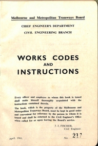
Book, Melbourne and Metropolitan Tramways Board (MMTB), "Melbourne and Metropolitan Tramways Board - Works Codes and Instructions", 1961
Book - green Rexene covers, with title - "Melbourne and Metropolitan Tramways Board - Works Codes and Instructions". Six sections, sewn into covers, dated April 1961, signed by J. J. Fisher, Civil Engineer. 118 pages plus covers. Book numbered "46". Provides an list of contents, giving provisional codes or instructions for works, instructions, about the maintenance and repair of the track welding, safe working, watchmen, care of lamps, and plant.On first page a signature in ink - "W. Armstrong"?trams, tramways, mmtb, track, maintenance -
 Ballarat Tramway Museum
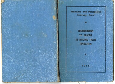
Book, Melbourne and Metropolitan Tramways Board (MMTB), "Melbourne and Metropolitan Tramways /Electric System /Instructions to Drivers in Electric Car Operation", 1966
Forty Eight page, side staple book within blue Rexene covers. Titled "Melbourne and Metropolitan Tramways /Electric System /Instructions to Drivers in Electric Car Operation" Dated 1966. Printed by Regent Press Pty Ltd, 457 Plenty Road, Preston. Provides in a Q & A format, instructions to drivers in electric car operation, photos of various types of controllers, an A.B.C. for tramways drivers - "always" points to remember and has a reference index. has the numbers 139 and 140 circled on inside of front cover. Has name "McCalee B" as the driver's name the document issued to and "5570" and the driver's number.trams, tramways, mmtb, drivers, training, instructions, motormen -
 Melbourne Tram Museum
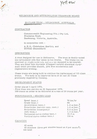
Document - Technical pamphlet/s, Melbourne & Metropolitan Tramways Board (MMTB), "Z3 Class tram - Melbourne Australia", c1980
Five page stapled photocopied technical pamphlet, providing detailed specifications and description of the Z3 vehicle produced by Commonwealth Engineering(Vic) in conjunction with AEG Telefunken and DUWAG. Provides details for Z3 class trams. Produced by the MMTB. Titled "Z3 Class tram - Melbourne Australia". Second copy from John Prideaux added 18/6/2017. Different version added 31/3/2019 from donation of Brian Weedon.Has word "yellow" in top right hand corner.trams, tramways, z3 class, mmtb, commonwealth engineering, specification, z class -
 Melbourne Tram Museum
Document - Personal Papers, Melbourne & Metropolitan Tramways Board (MMTB), "Consolidation of Melbourne and Metropolitan Tramway Acts", c1955
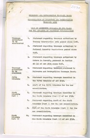
Set of personal papers - carbon copies of original documents involved with the "Consolidation of Melbourne and Metropolitan Tramway Acts" 1 - List of documents prepared by the Board for the Director of Statutory Consolidation 2 - Statement regarding tramways authorised by tramway construction acts passed since 1928 3 - ditto by National Security Regulations passed since 1928 4 - ditto authorised by Order in Council pursuant to Section 42(3) of Act 3732 since 1928.trams, tramways, mmtb, tramways, parliament, order in council, world war 2, acts of parliament -
 Melbourne Tram Museum
Document - Report, The Melbourne, Brunswick and Coburg Tramways Trust (MBCTT), "The Melbourne, Brunswick and Coburg Tramways Trust - Reports Statement of Accounts, Oct. 1916
Photocopy of Report - 15 foolscap pages - titled "The Melbourne, Brunswick and Coburg Tramways Trust - Reports Statement of Accounts for Twelve months ending 30th September 1916" Outlines opening of the line, extensions, finances, operations, costs. Has reports from the Manager, Statistics, Balance sheet, Revenue, horse tramway accounts, charts showing traffic revenue and expenditure and passengers carried. Dated 1/10/1916. Audited by R. H. Schackell.Has the stamp of the Tramway Museum Society on the rear of the first page.trams, tramways, mbctt, reports, construction, finances, horse trams -
 Melbourne Tram Museum
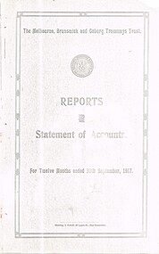
Document - Report, The Melbourne, Brunswick and Coburg Tramways Trust (MBCTT), "The Melbourne, Brunswick and Coburg Tramways Trust - Reports Statement of Accounts, Oct. 1917
Photocopy of Report - 17 foolscap pages - titled "The Melbourne, Brunswick and Coburg Tramways Trust - Reports Statement of Accounts for Twelve months ending 30th September 1917" Outlines construction, rolling stock, power supply, finances, operations, costs. Has reports from the Manager, Statistics, Balance sheet, Revenue, charts showing traffic revenue and expenditure and passengers carried. Dated 1/10/1917. Audited by R. H. Schackell.Has the stamp of the Tramway Museum Society on the rear of the first page.trams, tramways, mbctt, reports, construction, finances, operations -
 Melbourne Tram Museum
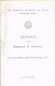
Document - Report, The Melbourne, Brunswick and Coburg Tramways Trust (MBCTT), "The Melbourne, Brunswick and Coburg Tramways Trust - Reports Statement of Accounts, Oct. 1918
Photocopy of Report - 12 foolscap pages - titled "The Melbourne, Brunswick and Coburg Tramways Trust - Reports Statement of Accounts for Twelve months ending 30th September 1919" Outlines extensions, rolling stock, power supply, finances, operations, costs. Has reports from the Manager, Statistics, Balance sheet, Revenue, charts showing traffic revenue and expenditure and passengers carried. Dated 1/10/1919. Audited by R. H. Schackell.Has the stamp of the Tramway Museum Society on the rear of the first page.trams, tramways, mbctt, reports, construction, finances, operations -
 Greensborough Historical Society
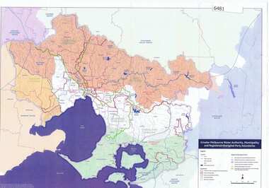
Maps, Greater Melbourne Water Authority, Municipality and Registered Aboriginal party Boundaries, 18/07/2018
Shows Melbourne Water and Municipal area boundaries, with boundaries of registered aboriginal parties, in central Victoria.Printed in colour one sideMap reference 20180746aborigines victoria, water supply, melbourne water -
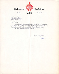 Robin Boyd Foundation
Letter, The Melbourne Beefsteak Club, The Melbourne Beefsteak Club to Robin Boyd, 20.11.1967
A reply to Boyd's letter acknowledging receipt of his letter of resignation from the Melbourne Beefsteak Club. -
 Port Melbourne Historical & Preservation Society
Document, Port of Melbourne Annual Report, 1979
Port of Melbourne Annual Report 1978-79 In 2 boxes labelled "Harbour Trust"melbourne harbor trust - port of melbourne authority, transport - shipping -
Port Melbourne Historical & Preservation Society
Document, Port of Melbourne Annual Report, 1980
Port of Melbourne Annual Report 1979-80 In 2 boxes labelled "Harbour Trust"melbourne harbor trust - port of melbourne authority, transport - shipping -
Port Melbourne Historical & Preservation Society
Document, Port of Melbourne Annual Report, 1984
Port of Melbourne Annual Report 1983-84 In 2 boxes labelled "Harbour Trust"melbourne harbor trust - port of melbourne authority, transport - shipping -
Port Melbourne Historical & Preservation Society
Document - Newsletter, City of Port Melbourne, Port Melbourne Amalgamation Bulletin, 1984
Set of newsletters issued by the City of Port Melbourne, Vol 1 No 1 Spring 1984local government - city of port melbourne, perce mcguire white, perce white, amalgamation -
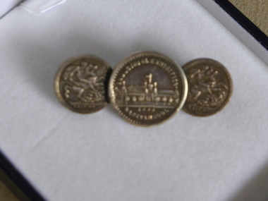 Warrnambool and District Historical Society Inc.
Tie Pin, Tie Pin half crown, Late 19th century
This tie pin has as its centerpiece a souvenir medal from the Warrnambool Industrial and Art Exhibition of 1896-7. This exhibition was held in the Town Hall and Council Buildings and the Mechanics’ Institute and temporary buildings at the corner of Liebig and Timor Streets, Warrnambool. It was held over three months and attracted many visitors and featured concerts, sports events, industrial exhibits and a variety of competitions. This is an interesting and important item. It is one of the more unusual mementoes from the Warrnambool Industrial and Art Exhibition and shows the use made of souvenirs from exhibitions around the world. This tiepin was purchased in an antique shop in England in the 20th century. This is a metal tie pin with three circular coins, soldered together at the edges. In the middle is a souvenir medal of the Warrnambool Industrial and Art Exhibition of 1896-7 showing an image of the Exhibition buildings at the corner of Timor and Liebig Streets on one side and a Coat of Arms on the other side. The two smaller coins on each side are imitation British half crowns. The clip at the back is soldered on to the two smaller coins Medal: Industrial Exhibition, Warrnambool 1896 Coins: 1889-90 warrnambool industrial and art exhibition 1896-7, warrnambool, tie pin -
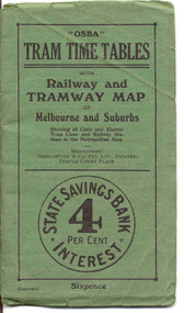 Ballarat Tramway Museum
Ephemera - Timetable/s, Osboldstone & Co Pty Ltd and Printers and Publishers Melbourne, "OSBA Tram Time Tables with Railway and Tramway Map, of Melbourne and Suburbs", 1920's
Yields information about the tram timetables applicable to Melbourne's trams, including cable and electric and demonstrates the spread of Melbourne's public transport system in the early 1920's.Forty Eight page printed book contained with oversize green heavy paper covers centre stapled with a coloured map glued into the rear cover of the book titled "OSBA Tram Time Tables with Railway and Tramway Map, of Melbourne and Suburbs". Published c1920 - shows Footscray system, Victoria St Flemington link, does not show Puckle St. Timetables details Fares, first and last cars for cable and electric lines, sections and other details of the various lines. Note page 44 and 45 cannot be accessed, paper not cut correctly during the printing process - leave as is. Map prepared by Gawler and Drummond Architects, shows in colour the cable routes, electric tramways, authorised tramways and railway lines. Municipalities shown in different colours. Map folded into 12 sections. Published by Osboldstone & Co Pty Ltd, Printers and Publishers, Temple Court Place, Melbourne. Price 6d. Full scan of document added as a pdf file 5/6/2019. map, timetables, melbourne, cable trams -
 Melbourne Tram Museum
Certificate, Melbourne & Metropolitan Tramways Board (MMTB), "Melbourne & Metropolitan Tramways Board - Eastern System - Certificate of Competency as Motorman", 1920
Bound book of 100 Certifications - "Melbourne & Metropolitan Tramways Board - Eastern System - Certificate of Competency as Motorman"". Consists of 100 pages of certificates, numbered 1 to 100, with butt of each certificate retained in the book. Bound with heavy card covers, green coloured on the outside of the covers, stapled with red binding cloth material. Each Certificate numbered, in top left hand corner, with space giving date, employee name, date of birth and signed or initialled by the Manager. On each certificate in the left hand edge is "Swinterton Bros & Co. Printers Melbourne". On each sheet in the top left hand corner is "MMTB/ES Form 105". The printers re-order number "9282" in pencil in the bottom right hand corner of the front cover and printed in the top left hand corner of the certificate. Certifications 1 to 18 and 99 and 100 have been removed - no names or dates inserted which indicates it may not have been used and the sheets torn out for "play" items.trams, tramways, mmtb, htt, motormen, certificates, eastern system -
 Whitehorse Historical Society Inc.
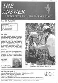
Pamphlet, The Answer Melbourne Legacy, 1995 & 1996
Two Junior Legacy, Melbourne Newsletters called 'The Answer'non-fictionTwo Junior Legacy, Melbourne Newsletters called 'The Answer'melbourne legacy, the answer -
 Kiewa Valley Historical Society
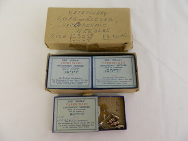
Hypodermic Needles - Veterinary
This medical / hospital equipment was used in the Tawonga District General Hospital which was built in the 1950's specifically for the increase in population due to the Kiewa Hydro Scheme.Historical: Shows the development of scientific hospital equipment. Provenance: Used in the Tawonga District General Hospital which was remote and therefore required good equipment. Good condition and good interpretation capacity.Cardboard box containing 5 packets of Veterinary Hypodermic Needles. Each packet has a detailed blue label on the front in blue writing with 'Veterinary' in red. Four packets contain 12 stainless steel Hypodermic Needles and the fifth pack has 5.Label on big box: Hand written: 'Veterinary / Luer - Record / Hypodermic / Needles / Size .../ E.V.Needles. Small packets: 'New "Solila" / Veterinary / Hypodermic Needles / Made in Australia / This box contains 12 / G 18 "V" 3 quarters"'/ Leur (followed by address)veterinary hypodermic needles, leur, medical, solila, tawonga district hospital -
 Kew Historical Society Inc
Plan, Melbourne & Metropolitan Board of Works : Borough of Kew : Detail Plan No.1291, 1905
The Melbourne and Metropolitan Board of Works (MMBW) plans were produced from the 1890s to the 1950s. They were crucial to the design and development of Melbourne's sewerage and drainage system. The plans, at a scale of 40 feet to 1 inch (1:480), provide a detailed historical record of Melbourne streetscapes and environmental features. Each plan covers one or two street blocks (roughly six streets), showing details of buildings, including garden layouts and ownership boundaries, and features such as laneways, drains, bridges, parks, municipal boundaries and other prominent landmarks as they existed at the time each plan was produced. (Source: State Library of Victoria). This plan forms part of a large group of MMBW plans and maps that was donated to the Society by the Mr Poulter, City Engineer of the City of Kew in 1989. Within this collection, thirty-five hand-coloured plans, backed with linen, are of statewide significance as they include annotations that provide details of construction materials used in buildings in the first decade of the 20th century as well as additional information about land ownership and usage. The copies in the Public Record Office Victoria and the State Library of Victoria are monochrome versions which do not denote building materials so that the maps in this collection are invaluable and unique tools for researchers and heritage consultants. A number of the plans are not held in the collection of the State Library of Victoria so they have the additional attribute of rarity.Original survey plan, issued by the MMBW to a contractor with responsibility for constructing sewers in the area identified on the plan within the Borough of Kew. The plan was at some stage hand-coloured, possibly by the contractor, but more likely by officers working in the Engineering Department of the Borough and later Town, then City of Kew. The hand-coloured sections of buildings on the plan were used to denote masonry or brick constructions (pink), weatherboard constructions (yellow), and public buildings (grey). A detail plan of part of Studley Park bordered by the major streets of Hodgson Street, Stevenson Street and Studley Park Road. Included on the plan are a number of significant Studley Park mansions in existence at the beginning of the 20th century. The unnamed street shown in the middle of the plan is McEvoy Street. The most important house still extant is Campion House, formerly named Dalsraith [Dalswraith] and Glendalough, owned since the 1940s by the Society of Jesus. Campion House can be seen on the corner of Hodgson and Studley Park Road. Its stables at the rear of the block have now been incorporated into a contemporary residence. An interesting feature of the plan is the 1910 annotation by Ed Seitz, professional designing engineer. Is Seitz the contractor who modified the MMBW original?melbourne and metropolitan board of works, detail plans, mmbw 1291, cartography -
 Kew Historical Society Inc
Plan, Melbourne and Metropolitan Board of Works, Melbourne & Metropolitan Board of Works : Borough of Kew : Detail Plan No.1294 & 1295, 1904
The Melbourne and Metropolitan Board of Works (MMBW) plans were produced from the 1890s to the 1950s. They were crucial to the design and development of Melbourne's sewerage and drainage system. The plans, at a scale of 40 feet to 1 inch (1:480), provide a detailed historical record of Melbourne streetscapes and environmental features. Each plan covers one or two street blocks (roughly six streets), showing details of buildings, including garden layouts and ownership boundaries, and features such as laneways, drains, bridges, parks, municipal boundaries and other prominent landmarks as they existed at the time each plan was produced. (Source: State Library of Victoria). This plan forms part of a large group of MMBW plans and maps that was donated to the Society by the Mr Poulter, City Engineer of the City of Kew in 1989. Within this collection, thirty-five hand-coloured plans, backed with linen, are of statewide significance as they include annotations that provide details of construction materials used in buildings in the first decade of the 20th century as well as additional information about land ownership and usage. The copies in the Public Record Office Victoria and the State Library of Victoria are monochrome versions which do not denote building materials so that the maps in this collection are invaluable and unique tools for researchers and heritage consultants. A number of the plans are not held in the collection of the State Library of Victoria so they have the additional attribute of rarity.Original survey plan, issued by the MMBW to a contractor with responsibility for constructing sewers in the area identified on the plan within the Borough of Kew. The plan was at some stage hand-coloured, possibly by the contractor, but more likely by officers working in the Engineering Department of the Borough and later Town, then City of Kew. The hand-coloured sections of buildings on the plan were used to denote masonry or brick constructions (pink), weatherboard constructions (yellow), and public buildings (grey).The streets and built structures in MMBW Detail Plan 1294 & 1295 were surveyed in 1903 and released to contractors in 1904. This plan is one of two in the collection where the lithographers amalgamated two separate plans. Both plans include sections of Studley Park. Dominating the south and west corners of Kew Junction are the Clifton and Kew Hotels. The Kew Hotel, owned by Patrick O’Shaughnessy was one of the oldest in Kew. MMBW plans were amended over time to take account of new subdivisions such as that which created Merrion Place. Of the four mansions shown in Studley Park Road, three remain – ‘Field Place’, the home of Frances Henty, ‘Leaghur’ and ‘Darley’. ‘Byram’ (later ‘Goathland’, then ‘Tara Hall’) was an architectural marvel. Designed in 1888 by E.G. Kilburn for the paper magnate George Ramsden, it was demolished in 1960. While an earlier sale of the southern section of Byram had created Tara Avenue in 1927, the demolition of the house in 1960 enabled the extension of Tara Avenue northward.melbourne and metropolitan board of works, detail plans, mmbw 1294, mmbw 1295, cartography -
 Kew Historical Society Inc
Plan, Melbourne & Metropolitan Board of Works : Borough of Kew : Detail Plan No.1297, 1904
The Melbourne and Metropolitan Board of Works (MMBW) plans were produced from the 1890s to the 1950s. They were crucial to the design and development of Melbourne's sewerage and drainage system. The plans, at a scale of 40 feet to 1 inch (1:480), provide a detailed historical record of Melbourne streetscapes and environmental features. Each plan covers one or two street blocks (roughly six streets), showing details of buildings, including garden layouts and ownership boundaries, and features such as laneways, drains, bridges, parks, municipal boundaries and other prominent landmarks as they existed at the time each plan was produced. (Source: State Library of Victoria)This plan forms part of a large group of MMBW plans and maps that was donated to the Society by the Mr Poulter, City Engineer of the City of Kew in 1989. Within this collection, thirty-five hand-coloured plans, backed with linen, are of statewide significance as they include annotations that provide details of construction materials used in buildings in the first decade of the 20th century as well as additional information about land ownership and usage. The copies in the Public Record Office Victoria and the State Library of Victoria are monochrome versions which do not denote building materials so that the maps in this collection are invaluable and unique tools for researchers and heritage consultants. A number of the plans are not held in the collection of the State Library of Victoria so they have the additional attribute of rarity.Original survey plan, issued by the MMBW to a sewage contractor with responsibility for constructing sewers in the area identified on the plan within the Borough of Kew. The plan was at some stage hand-coloured, possibly by the contractor, but more likely by officers working in the Engineering Department of the Borough and later Town, then City of Kew. The hand-coloured sections of buildings on the plan were used to denote masonry or brick constructions (pink), weatherboard constructions (yellow), and public buildings (grey). This plan of Kew encompasses the area bounded by Barkers Road, High Street and Stevenson Street. Because of the angle created by High Street, a number of houses on the northern side of High Street are shown. The area is dominated by one of the great original landholdings in Kew, described here as the ‘Findon Paddock’. ‘Findon’, the house from which the name of the paddock was taken fronts Stevenson Street and was clearly a rambling structure. The best-known occupant of Findon was Henry ‘Money Miller’ who bought the house in 1871. Miller was a member of Victoria’s first parliament and assisted in the framing of its constitution. Findon was to be subdivided as early as 1912, when the Findon Subdivision was advertised to be sold by auction. In the plan of the subdivision, the original house is not shown, so, presumably it had previously been demolished. Fincham & Son moved the organ, built by Henry Willis, which was installed in the house, first to ‘Whernside’ in Toorak, and later to the Box Hill Methodist Church.melbourne and metropolitan board of works, detail plans, mmbw 1297, cartography, kew (vic.) — municipal collection -
 Kew Historical Society Inc
Plan, Melbourne & Metropolitan Board of Works : Borough of Kew : Detail Plan No.1301, 1910
The Melbourne and Metropolitan Board of Works (MMBW) plans were produced from the 1890s to the 1950s. They were crucial to the design and development of Melbourne's sewerage and drainage system. The plans, at a scale of 40 feet to 1 inch (1:480), provide a detailed historical record of Melbourne streetscapes and environmental features. Each plan covers one or two street blocks (roughly six streets), showing details of buildings, including garden layouts and ownership boundaries, and features such as laneways, drains, bridges, parks, municipal boundaries and other prominent landmarks as they existed at the time each plan was produced. (Source: State Library of Victoria)This plan forms part of a large group of MMBW plans and maps that was donated to the Society by the Mr Poulter, City Engineer of the City of Kew in 1989. Within this collection, thirty-five hand-coloured plans, backed with linen, are of statewide significance as they include annotations that provide details of construction materials used in buildings in the first decade of the 20th century as well as additional information about land ownership and usage. The copies in the Public Record Office Victoria and the State Library of Victoria are monochrome versions which do not denote building materials so that the maps in this collection are invaluable and unique tools for researchers and heritage consultants. A number of the plans are not held in the collection of the State Library of Victoria so they have the additional attribute of rarity.Original survey plan, issued by the MMBW to a contractor with responsibility for constructing sewers in the area identified on the plan within the Borough of Kew. The plan was at some stage hand-coloured, possibly by the contractor, but more likely by officers working in the Engineering Department of the Borough and later Town, then City of Kew. The hand-coloured sections of buildings on the plan were used to denote masonry or brick constructions (pink), weatherboard constructions (yellow), and public buildings (grey). Throughout its history, the land in what is known today as Studley Ward of the City of Boroondara has been subject to continuing subdivision. This is evident in Plan 1301, where later hands have modified the original map to include streets created subsequent to the printing of the plan in 1904. Other annotations such as the ‘Reserved for Road Purposes’ beside the Yarra never eventuated. The plan continued to be modified to at least 1953, when a later hand noted that a particular site was ‘Property site P. McIntyre house’ in Swinton Avenue. Two significant houses in the area are outlined on the plan: ‘Swinton’ on the corner of the streets then named Effey and Maud Streets (now Swinton Avenue) and ‘Fairhaven’ [unnamed] in Stevenson Street. The gardens of the two David Syme owned mansions of ‘Blythswood’ and ‘Rockingham’, stretching down to the River Yarra, are also represented.melbourne and metropolitan board of works, detail plans, mmbw 1301, cartography -
 Kew Historical Society Inc
Plan, Melbourne & Metropolitan Board of Works : Borough of Kew : Detail Plan No.1302, 1910
The Melbourne and Metropolitan Board of Works (MMBW) plans were produced from the 1890s to the 1950s. They were crucial to the design and development of Melbourne's sewerage and drainage system. The plans, at a scale of 40 feet to 1 inch (1:480), provide a detailed historical record of Melbourne streetscapes and environmental features. Each plan covers one or two street blocks (roughly six streets), showing details of buildings, including garden layouts and ownership boundaries, and features such as laneways, drains, bridges, parks, municipal boundaries and other prominent landmarks as they existed at the time each plan was produced. (Source: State Library of Victoria)This plan forms part of a large group of MMBW plans and maps that was donated to the Society by the Mr Poulter, City Engineer of the City of Kew in 1989. Within this collection, thirty-five hand-coloured plans, backed with linen, are of statewide significance as they include annotations that provide details of construction materials used in buildings in the first decade of the 20th century as well as additional information about land ownership and usage. The copies in the Public Record Office Victoria and the State Library of Victoria are monochrome versions which do not denote building materials so that the maps in this collection are invaluable and unique tools for researchers and heritage consultants. A number of the plans are not held in the collection of the State Library of Victoria so they have the additional attribute of rarity.Original survey plan, issued by the MMBW to a contractor with responsibility for constructing sewers in the area identified on the plan within the Borough of Kew. The plan was at some stage hand-coloured, possibly by the contractor, but more likely by officers working in the Engineering Department of the Borough and later Town, then City of Kew. The hand-coloured sections of buildings on the plan were used to denote masonry or brick constructions (pink), weatherboard constructions (yellow), and public buildings (grey). The absence of buildings and or property in Kew facing the Yarra is the most notable feature of this plan. Walmer Street and its bridge stretched, then and now, from Studley Park Road to Victoria Street, Richmond. On the Richmond side of the Yarra, there was evidence in 1904 of industry (‘Wool shed’; Soap Works’) and entertainment (‘Skittle Alley’). In reality, another Plan (No.1303) shows Chinese Gardens bordering the Yarra on the Kew side and buildings in Young Street.melbourne and metropolitan board of works, detail plans, mmbw 1302, cartography -
 Kew Historical Society Inc
Plan, Melbourne & Metropolitan Board of Works : Borough of Kew : Detail Plan No.1350, 1910
The Melbourne and Metropolitan Board of Works (MMBW) plans were produced from the 1890s to the 1950s. They were crucial to the design and development of Melbourne's sewerage and drainage system. The plans, at a scale of 40 feet to 1 inch (1:480), provide a detailed historical record of Melbourne streetscapes and environmental features. Each plan covers one or two street blocks (roughly six streets), showing details of buildings, including garden layouts and ownership boundaries, and features such as laneways, drains, bridges, parks, municipal boundaries and other prominent landmarks as they existed at the time each plan was produced. (Source: State Library of Victoria). This plan forms part of a large group of MMBW plans and maps that was donated to the Society by the Mr Poulter, City Engineer of the City of Kew in 1989. Within this collection, thirty-five hand-coloured plans, backed with linen, are of statewide significance as they include annotations that provide details of construction materials used in buildings in the first decade of the 20th century as well as additional information about land ownership and usage. The copies in the Public Record Office Victoria and the State Library of Victoria are monochrome versions which do not denote building materials so that the maps in this collection are invaluable and unique tools for researchers and heritage consultants. A number of the plans are not held in the collection of the State Library of Victoria so they have the additional attribute of rarity.Original survey plan, issued by the MMBW to a contractor with responsibility for constructing sewers in the area identified on the plan within the Borough of Kew. The plan was at some stage hand-coloured, possibly by the contractor, but more likely by officers working in the Engineering Department of the Borough and later Town, then City of Kew. The hand-coloured sections of buildings on the plan were used to denote masonry or brick constructions (pink), weatherboard constructions (yellow), and public buildings (grey). MMBW Plan No. 1350 depicts the western end of Studley Park on the north side of the Studley Park Road. ‘Raheen’, then the home of Sir Henry Wrixon is named, the plan identifying those parts of the house that were built of brick and timber. The two houses between Raheen and the River Yarra are also shown. Other parts of the plan show neighbouring streets: Yarra Street, Studley Park Avenue, Studley Street and Fenwick Street. Each, apart from Fenwick Street was subsequently renamed. At the corner of Fenwick and Stawell Streets, the home of Joseph Butterworth Coombs, later called ‘Hope Mansell’, is represented but unnamed.melbourne and metropolitan board of works, detail plans, mmbw 1350, cartography