Showing 1236 items matching "permit"
-
 Glenelg Shire Council Cultural Collection
Certificate - Certificate - Historic Buildings, Portland Town Hall, 1974
From the Victorian Heritage Register: The foundation stone of the original Portland Town Hall was laid by William Learmonth on 21st September, 1863 following a competition and subsequent public controversy over the permitted entry of architect John Barrow. The conservative classical design of municipal surveyor Alexander Ross was preferred and this axially planned design with central council chamber and side offices fronted by a fine axed pedimented gable entablature of basalt and Tuscan Doric pilasters was completed by 24th may 1864. The old Town Hall is one of a distinguished group of public buildings in Portland and an interesting example of conservative classical architecture of the first years of settlement in western Victoria. The basalt structure was partially erected of stone from the Portland stockade and has significant historical associations with local Government administration in the district. The Town Hall is the most impressive work of Alexander Ross, a surveyor architect whose career remains largely undocumented. The old Town Hall at Portland has been discreetly extended at the rear to provide additional meeting room accommodation. The premises are no longer used for local government administration.A4 sized certificate demonstrating Portland Town Hall's special significance to the state of Victoria & inclusion on the Historic Building Register. Singed by Robert Maclellan, Minister for planning & Historic Buildings Council Chairperson. Red seal attached, bottom right.portland town hall, history house, heritage register, historic buildings, certificate -
 City of Moorabbin Historical Society (Operating the Box Cottage Museum)
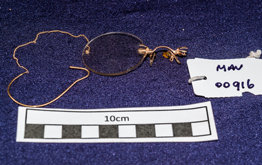
Personal Effects, lady’s Pince-nez ½ with fine gold chain, c1900
Glasses, also known as eyeglasses or spectacles, are frames bearing lenses worn in front of the eyes. They are normally used for vision correction or eye protection. Pince-nez is a French style of spectacles, popular in the 19th century, that are supported without earpieces, by pinching the bridge of the nose. The name comes from French pincer, "to pinch", and nez, "nose". Although pince-nez were used in Europe in the 15th, 16th, and 17th centuries, modern ones appeared in the 1840s and reached their peak popularity around 1880 to 1900 A solid bridge piece is moulded to fit the curvature of the bridge of the nose. They are anchored onto the bridge of the nose via two small spring-loaded clips terminating in special nose-pads made from bone or tortoise shell on metal called plaquettes, which are tweezered apart for placement on the face through applying pressure to two small lever-like finger-pieces located on the front of the bridge. Plaquettes could be either hinged and flexible, permitting a better fit, or static as in the older examples of this type.. They were popular from the 1890s through to the 1950s, One half of a pair of lady’s Pince-nez eyeglasses with 1 gold rimmed glass lens , a gold style bridge and a fine gold chain that is attached to the side of the lens frame and to a shaped over- ear metal piece. eyes, spectacles, eye glasses, optometry, moorabbin, bentleigh, cheltenham, market gardeners, pioneers, early settlers, pince-nez -
 Kiewa Valley Historical Society
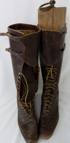
Boots Riding Women's, Circa 1950's
This pair of "adjustable" boots came from the 1950's era in which the majority of footwear was either locally manufactured or imported from England or Europe. Quality hard wearing leather was a rural necessity especially for the cattle mustering activity in the Kiewa Valley and the Bogong High Plains region. The late 1900's provided a cheaper made riding boot from Asia, however many rural based riders still prefer an Australian made boot. The better quality (stronger stitching) of Australian boots is the main considerations of "stock horse riders". In 1947 a scientific research project started to provide an impact analysis of any damage to alpine vegetation by cattle grazing in the Alpine regions incorporating the Bogong High Plains area. This monitoring is the longest running ecological study ever undertaken in Australia. From this study, compelling evidence was presented to the Victorian Government to cease cattle grazing in the Alpine regions including the Bogong High Plains. All grazing was banned by the Victorian Government in 2005. Recreational horse riding within the Bogong High Plains is still permitted.These pair of women's riding boots are very significant to the Kiewa Valley as the boots were worn by one of the descendants of a pioneer family living and operating a cattle station before the SEC Hydro Electricity Scheme opened up the semi remote rural location in the 1950's. These boots were worn during the annual six weeks (approx.) mustering of cattle in the Bogong High Plains location (Victorian Alps region). The owner of these boots was Clare Roper, part of the Roper Family who built a "lodging" hut on the "High Plains" for accommodating riders during the periods (up to six weeks) when controlling grazing cattle during the summer muster seasons. It was unusual for women in the early to mid 1900's to go up on the High Plains to join the muster, which Clare Roper often did. These boots have high historical significance and good interpretive capacity.These brown "knee high" lady riding boots, are fastened by long "boot" laces which go from the base of the "fastening" position to a boot height of 22 cm. At the top end of the boot is a leather flap which crosses the front section of the boot and is fastened to the outside leg region by two straps. These provide the wearer with an adjustable tie. The boot has a "tongue" of 22 mm long. The boot has six pairs of metal boot lace "hooks" and eight pairs of boot lace "eyelets".ladies riding boots. cattle mustering footwear. rural footwear. cattlemen. bogong high plains. roper family. horses. -
 Federation University Historical Collection
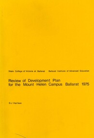
Book, G.J. Harrison, Review of Development Plan for the Mount Helen Campus Ballarat, 1975, 1975
In 1967 the site for the Mt Helen Campus was selected and purchased to permit the tertiary division of the Ballarat School of Mines - the Ballarat Institute of Advanced Education (BIAE) to move from the crowded Lydiard Street site, to occupy new accommodation designed for the purpose. The brief given to the campus master planners called for the creation of a modern, attractive, efficient and stimulating concept. It called for careful landscaping and enhancement of the environment, but above all it demanded flexibility for an unpredictable future. During 1974 major new directions were made at Government level quite beyond the scale of change that had been foreseen in 1967. This change was to be that of merging BIAE and the State College of Victoria at Ballarat (formerly Ballarat Teachers' College) into one large new college of broadened scope. By the end of 1974 joint committees representing the still separate, autonomous Councils of the two institutions had agreed on the means of achieving the merger to the extent that a new brief as prepared and given to G.J. Harrison, one of the original master planners who had been chosen to revise the plan to meet the new needs. Yellow soft covered book of 63 pages reviewing the Development Plan for Mount Helen Campusuniversity of ballarat, ballarat institute of advanced education, mount helen, master plan, ballarat college of advanced education, mb john, ian gordon, pdf, development plan, mount helen campus, g.j. harrison, state college of victoria ballarat, m.b. john, canadian valley, aquinas college, site survey, land use zones, landscaping, campus plan, mt helen campus -
 Flagstaff Hill Maritime Museum and Village
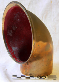
Functional object - Dorade Cowl, 1930-1940s
A dorade is a type of ventilator that permits the passage of air in and out of the cabin or engine room of a boat while keeping rain, spray, and sea wash out. The basic form is a low, rectangular box fixed to the deck or cabin top, fitted with interleaving vertical baffles. The baffles alternate to be free at the floor of the box, or free at the ceiling, forming a series of chambers. A horn-shaped ventilation cowl is usually fitted facing forward to a large hole at the top of the chamber at one end of the box with another large hole opening down into the boat from the chamber at the other end. Limber holes perforate the wall of the box at the floor of each chamber. Dorade boxes operate on the principle that air can pass relatively freely through the chambers, yet rain or sea wash will be trapped in successive chambers and drain out the small holes in the sides of the box. The first appearance of Dorade boxes was on the Olin Stephens-designed Dorade, a yacht built in 1929 for ocean racing. As originally built, the Dorade's vents led directly below, but this was found to allow water below, and the vents were modified in the early 1930s.An early piece of marine equipment from the 1930s and 40s that still is in use today on smaller vessels and ships.Dorade Cowl (Ventilator), brass casting with wide open mouth twisted to side. Painted red inside.warrnambool, flagstaff-hill, flagstaff-hill-maritime-museum, maritime-museum, shipwreck-coast, flagstaff-hill-maritime-village, dorade (ventilator), dorade, ventilator, marine equipment, ships fittings -
 Flagstaff Hill Maritime Museum and Village
Functional object - Dorade Vent Cowl, 1930s
A dorade is a type of ventilator that permits the passage of air in and out of the cabin or engine room of a boat while keeping rain, spray, and sea wash out. The basic form is a low, rectangular box fixed to the deck or cabin top, fitted with interleaving vertical baffles. The baffles alternate to be free at the floor of the box, or free at the ceiling, forming a series of chambers. A horn-shaped ventilation cowl is usually fitted facing forward to a large hole at the top of the chamber at one end of the box with another large hole opening down into the boat from the chamber at the other end. Limber holes perforate the wall of the box at the floor of each chamber. Dorade boxes operate on the principle that air can pass relatively freely through the chambers, yet rain or sea wash will be trapped in successive chambers and drain out the small holes in the sides of the box. The first appearance of Dorade boxes was on the Olin Stephens-designed Dorade, a yacht built in 1929 for ocean racing. As originally built, the Dorade's vents led directly below, but this was found to allow water below, and the vents were modified in the early 1930s.An early piece of marine equipment from the 1930s that still is in use today on smaller vessels to improve below deck ventilation. Dorade Ventilator Cowl brass casting with wide open mouth twisted to side with swivel base. Box and baffles missingNonewarrnambool, flagstaff-hill, flagstaff-hill-maritime-museum, maritime-museum, shipwreck-coast, flagstaff-hill-maritime-village, ventilator, dorade, maritime equipment, ships fittings, ventilator box -
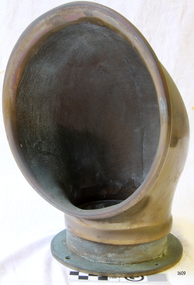
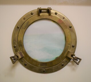 Geelong Naval and Maritime Museum
Tool - Porthole, Unsure
A porthole, sometimes called bull's-eye window or bull's-eye, is a circular window used on the hull of ships to admit light and air. Though the term is of maritime origin, it is also used to describe round windows on armoured vehicles, aircraft, automobiles (the Ford Thunderbird a notable example) and even spacecraft. On a ship, the function of a porthole, when open, is to permit light and fresh air to enter the dark and often damp below-deck quarters of the vessel. It also affords below-deck occupants a limited view to the outside world. When closed, the porthole provides a strong water-tight, weather-tight and sometimes light-tight barrier (not in the case however). A porthole on a ship may also be called a side scuttle (side hole), as officially termed in the International Convention for the Safety of Life at Sea. This term is used in the U.S. Code of Federal Regulations. It is also used in related rules and regulations for the construction of ships. The use of the word "side scuttle" instead of "porthole" is meant to be broad, including any covered or uncovered hole in the side of the vessel. This porthole is a useful demonstration of naval technology to give people an insight into life at see. Small windows such as this example could be all people would see on long see voyage across rough seas. Commanding officers scuttle made of brass with glass opening windowmaritime technology -
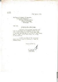 Melbourne Legacy
Letter, Attention Mr. Eric Young. Re: Bert Frank
00355.1 Letter dated 17 March 1943 to National Service Office to advise the appointment of Mr Bert Frank to the position of manager of the Legacy Club Hostel (Holmbush). Also requesting a permit to do so. 00355.2 Letter dated 18 March 1943 from the Department of Labour and National Service advising the was no objection to the appointment. Holmbush was the first hostel for children that Legacy started and operated from April 1943. It was later renamed Blamey House after another hostel called Blamey House was closed. Melbourne Legacy ran three residences: Blamey House (purchased 1947) , Stanhope (purchased 1945) and Harelands (purchased 1950), to take care of children whose fathers were servicemen, and who may have been left orphans, or whose mother may have been unable to care for them herself. Harelands accommodated boys and girls under the age of 14, Blamey House looked after boys over 14, and Stanhope looked after girls over 14. The children were cared for until they were old enough to become independent.Record of the Government's role in appointment of labour during 1943.00355.1 Blue quarto copy paper, black type, two hole punched. 00355.2 White quarto letterhead, black type, two hole punched.00355.1 Initialled in blue ink by J Barnes. 00355.2 Signed in black ink by R.W. Drummond, Employment Division, Manpower Directorate of Department of Labour and National Serviceresidences, holmbush, staff, bert frank -
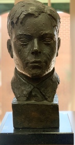 Mentone Grammar School
Sculpture (collection), 'Boy', 1967
Karl Duldig -
 Eltham District Historical Society Inc
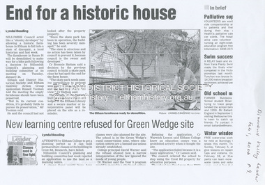
Document - Property Binder, 66 Susan Street, Eltham
Newspaper clipping (photocopy/digital only): End for a historic house, Lyndal Reading, Diamond Valley Leader, February 1, 2006, p9Alistair Knox Park, Eltham, Eltham Skate Park A small cream cottage with green roof. The farmhouse built in the late 1800s by the Crozier Family. Subsequently owned by the Hill Family. Purchased in the early 1960s and by 1965 the property was owned by the Shire of Eltham. Employees of the Shire lived in the house. Susan Street originally ran all the way north of Bridge Street to the bend where it turned to the left into Brisbane Street. Today that section of Susan Street has been renamed as an extension of Brisbane Street. In 2006 the Shire of Nillumbik demolished the house which had been subject to extensive vandalism. In accordance with heritage advice and a permit condition a sign was placed on the site outlining the history of the building. This was installed and remained in place till about 2016 when it was removed. The land adjoins Alistair Knox Park. By 2010 the Eltham Skate Park was developed. In 2022 a major renovation and extension took place. Sources: EDHS Newsletter No 171 November 2006alistair knox park, eltham, eltham skate park, house, susan street -
 Kiewa Valley Historical Society
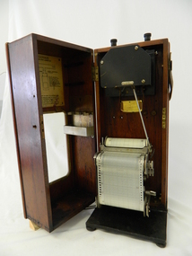
Meter Ammeter Recorder, Circa 1950
This testing voltmeter recorder was last certified by SEC Vic laboratories on the 17/4/77. It was used extensively as mobile recorder placed for periods of one month at locations experiencing unacceptable fluctuations of power. These locations would cover the North East regions of Victoria. They cover voltage drops at domestic and business properties especially those that were experiencing regular fluctuations(daily) at approximately the same time of the day. As the electrical network is required to operate within a set level of voltage, fluctuations outside of this has to be investigated and necessary remedial action taken. This is especially so for rural properties where power "drainage" can occur through animal/bird and tree interference. It can also be the result of defective wiring and overloading at peek operational times (milking machines).This mobile voltage recorder is very significant to the Kiewa Valley because it highlights the difficulties that can occur in maintaining a power supply that experiences fluctuating power demands by the rural industries that it supplies. The requirement of a mobile testing apparatus to cover the various sections in the Kiewa Valley and other rural areas in the northeast region is one of necessity as electricity once connected to a rural property is a labour saving supply as generators on rural properties require a higher degree of maintenance an ultimately at a higher cost. The testing of the SEC Vic supplied electricity to rural properties,those who had previously run on generators, had to be quick and unassuming with certainty of correct supply levels.The mechanism of this voltage recorder has been installed(by the manufacturer) into its own protective wooden box. This box has a front (swing open) lockable section which permits direct access to the installed measuring equipment (for servicing and data collection). The top section of the box has two screw on terminals for access to the machine being tested. This tester has its own inbuilt ink supply facilities and a mechanical clockwork device that unwinds a roll of paper onto a second roll at a rate of 10 mm per hour. The recording chart is marked with time slots against voltage. There is a recording arm which has an ink pen at the end. Both arm and pen carry the ink supply from the ink reservoir, located on the left side of the cabinet door in specially constructed bottle holder( three small bottle capacity). To record a suspect power problem to a home or business establishment the voltmeter is connected to a power supply outlet being tested and wind the recording clockwork mechanism (gives a four week running time). Before leaving the recorder in situ the electrician checks to see if the chart is recording the correct voltage and that the clock mechanism is advancing correctly.On the front of the access "door" at the top a metal label "RECORDING AMMETER" below this "MURDAY SYSTEM" below this "ALTERNATING CURRENT" and below this the manufacturer's registered number "No. 139156" Below this is a metal tag with State Electricity Commission of Victoria Electrical Engineer's Section equipment number "338" Below these tags and above the viewing window is the manufacturer's dtails "EVERSHED & VIGNOLES Led LONDON"sec vic kiewa hydro scheme, alternate energy supplies, alpine feasibility studies temperature, rainfall, power outages -
 Ballarat Tramway Museum
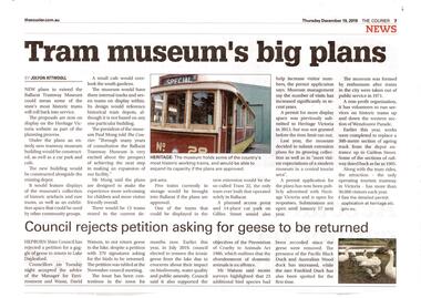
Newspaper, The Courier Ballarat, "Tram Museum's big plans", Dec. 2019
Set of 7 items related to the proposed extension of the BTM's depot to the south, Dec. 2019. Comprises: .1 - Newspaper clipping from The Courier, 19/12/2019 titled "Tram Museum's big plans", advising that the proposal was being advertised by Heritage Victoria, along with a photo of No. 26. .2 - Newspaper clipping from The Courier, 18/12/2019 for the advertising the permit application under the Heritage Act 2017 - in the Public Notice section. .3 - Digital image of "Museum Extension - Heritage Impact Statement - revised Oct. 2019." - 16 A4 pages. .4 - Digital image of Plans - 8 sheets of the proposal by MKM constructions. .5 - Digital image of Report - Urber Arbor - Arboricultural Report - Tree Management Plan. .6 - Digital image of Coloured site plan and drawings showing proposal depot trackwork and support mechanism around trees. Note this does not open on dbTextWorks interface. .7 - Digital image of 11 sheets of concept plans for the exterior and interior of the museum proposal by MKM Constructions. .8 - digital image of the advertising sign on the rear wall of the depot taken 7-1-2019. A similar poster was on the south east corner of the depot.btm, museum, drawings, depot extensions, heritage buildings, heritage, trackwork -
 Warrnambool and District Historical Society Inc.
Documents, Childer's Cove, 1920-1940's
Childers Cove is situated about 15 ks east of Warrnambool in the area known as Mepunga. It is named after the shipwreck of 'The Children.The documents relate to the running of the Childer's Cove Progress Association. There are a number of social activities including gymkhanas, racing meetings, making of roads and improving with planting trees There are many names which are still familiar with the area nearly 100 years later, including Wallace, McDowall, Burleigh, Murnane, Bonnett, Abraham Laidlaw Keogh Holloway and Palmer. Some of the meetings were held at the Mepunga South School with others held at Eckers Hotel Warrnambool and some at the race course. Fundraising events were held also from athletic meetings and district school children's races. This collection of papers is representative of many small communities around Australia where people came together and worked to improve their community facilities. It therefore has strong social and historic significance.This is a collection of papers most of which relate to the Childer's Cove Progress Association. Included are: .1 Minute Book/ Exercise book Childer's Cove Progress Association.May 1928-1932 .2 Minute Book/ Exercise book Childer's Cove Progress Association. 1924-1926 .3 Letter from Warrnambool Football Club 1930. .4 Account Archibald MacFarlane & Co March 1929 .5 Western District Racing Association Oct 1929. .6 Federal Taxation Dep Re Entertainment Tax 11/02/1930 .7 Chief Secretary Office re Racing Permits March 1923. .8-.9 Warrnambool Standard Invoices Jan 1930's .10 Archibald MacFarlane & Co Jan 1930. .11 Chief Office for Stamp Duties 12/02/1928 .12 Flyer - Childer's Cove Progress Association April 17 1926. .13 Flyer- Monster Gymkhana 12/02/ 1927. .14 Handwritten Invoice Charles Palmer Nov 1929. .15 Cheque Book Childer's Cove Progress Association 1929-31. .16 Deposit Book Childer's Cove Progress Association 1932-1942 .17 Bundle of invoices. .1 C J Caddy & Sons.2 Western Ice & Ice Products .3 Department of Lands & Survey Aug 1923 .4 J S Tait re Licence April 1924 .5 Warrnambool Standard31/12/1923 .6 Warrnambool Standard 31/03/1924 .7 Devenish & Co August 1924 .8 Warrnambool Standard 31/06/1924 H J Paynter & Co 03/05/1924 .10 Chief Secretary's Office Melbourne 01/05/1924 with receipt. .11 Permit for a race meeting April 19 1924 .12 Commonwealth of Australia Entertainment Tax 06/09/1924.13 Commonwealth of Australia Entertainment Notice 27/08/01924 .14 Commonwealth of Australia Entertainment Tax notice 12/08/1924 .18 William Ardlie handwritten letter 28/03/1928 .19 Envelope Addressed to W R Abrahams .20 Final notice Handwritten Charles Palmer Jan 1930. .21 Balance Sheet Childer's Cove Racing Club 18/03/1929 .22 H J Paynter & Co Account and receipt 25/02/1930. .23 Raglan Parade Timber Yards Alex Donaldson Feb 1930. .24 The School Paper Feb 1964 No 741 childer's cove, mepunga, childer's cove progress association -
 Australian Gliding Museum
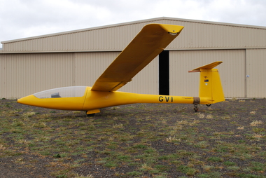
Machine - Glider - Sailplane
MOBA2 is a 15 metre sailplane designed by Gary Sunderland, who was an aeronautical engineer working for the Department of Civil Aviation (Australia) and a member of the Victorian Motorless Flight Group (VMFG). The design gave effect to ideas that he developed circa 1970 for an aircraft that he could build himself. He entered a 13 metre wingspan version of his MOBA design (MOBA2B) in an Australian Gliding sailplane design competition that was announced in 1970. The competition called for sailplane designs with a maximum wingspan of 13 metres that could be built by amateurs in a small workshop with limited tools and facilities. In 1973, Gary’s MOBA was judged by the competition panel as equal best with the other outstanding submission, which were chosen from a field of 19 entrants. However, after gathering further information and deliberation by the competition panel neither of the two outstanding designs were chosen as the winner. Notwithstanding the outcome, in 1974 Gary proceeded built his glider to the original 15 metre design. The wing was equipped with camber changing flaps that were permitted under special standard class rules for the 1974 world championships. Changes were made along the way in the light of construction experience and the completed glider was given the designation MOBA2C. The glider first flew on 12 December 1979. It was never flown in standard class competition as by the time the glider was built the special 1974 rules were revoked and wing flaps were no longer permitted in that class. However, Gary flew MOBA2C in the Australian national gliding competitions held at Benalla in the summer of 1979 / 1980 competing in the open class. After adjustment to the aileron gearing during initial trials MOBA2C was found to fly well and in competition produced performances believed to be better than contemporary standard class sailplanes but not as good as the open class machines. The glider was later modified in a number of respects including amongst other things the installation of spoilers located just forward of the wing flaps and by increasing the chord marginally at the wing root. With these changes the glider type was given the designation MOBA2D. The last recorded flights occurred in February 1996 at which time MOBA2 had flown an aggregate of 401 hours and 59 minutes during its 297 launches. Its operational life was brought to an end due to expansion of the foam in the wings causing distortion of the wing surface.The MOBA2 is a notable home built 1970s sailplane design that featured a number of innovative elements including composite construction without the need for expensive jigs, nose cone canopy and asymmetrical placement of control column.Composite single seat glider / sailplane finished in bright yellowRegistration "GVI" on fuselage; Kangaroo, Australian Flag and VMFG decals on vertical stabiliseraustralian gliding, glider, sailplane, moba2b, moba2c, sunderland, moba2d, victorian motorless flight group, vmfg -
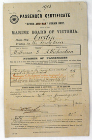 Orbost & District Historical Society
certificate, 30th January 1903
This certificate was issued on January 30, 1903 to Captain Alan Richardson by the Marine Board of Victoria entitling her to carry 25 passengers and only 10 passengers when engaged in towage service. Two children under 12 years of age to be reckoned as one passenger. The penalty of 20 pounds would be levied if these limits were exceeded. the certificate was valid until 21st July 1903. The original Paddle Steamer Curlip was built by Sam Richardson and his sons Mark, Albert and Frank, at their sawmill at Tabbara, a pioneering settlement on the Brodribb River, a tributary of the Snowy River. Curlip's keel was laid on 14th October 1889 and PS Curlip was launched in 1890. The Paddle Steamer Curlip was designed to travel up and down the Snowy and Brodribb Rivers with essential supplies from coastal ketches and schooners, that plied their trade up and down the coast between Melbourne, Sydney and Tasmania. The Curlip regularly towed one or two barges and up to five barges loaded with local farming produce and timber for the thriving cities, that was loaded offshore or in the Snowy River estuary, tide and depth permitting, on to the trading vessels.This item is associated with the P.S. Curlip and the Richardson family, early Orbost pioneers.A paper passenger certificate for a river steam ship.Details are handwritten in black and red ink.curlip-p.s. certificate-passenger richardson -
 Kew Historical Society Inc
Document - Urban Planning Document, City of Kew, City of Kew : Minimum Size of Allotment Required, 1945-1955
A document outlining the relevant by-laws produced by the City Of Kew to regulate the minimum size of allotments in Barkers Road, Burke Road, Cotham Road, Glenferrie Road and Studley Park Road, as well as in other streets more generally. The by-laws specify the size of allotments in which single unit dwellings, attached houses and maisonettes, and flats could be built. In the ‘main streets’ a minimum land area for single unit dwellings was 8,100 square feet, with an average frontage of 60’ and a depth of 135’. In other streets this was reduced to an overall size of 6,250 square feet, with an average dimensions of 50’ x 125’. In specifying the land area required by flats, different sizes were regulated for the construction of between two and six flats. Six flats at the time when the regulations were passed must have been the upper limit permitted. Understanding the size of land listed in imperial measurements can be a challenge. Within Australia, the so-called quarter acre block was approximately 11,000 square feet. Those specified in the by-laws would appear to be smaller. The document was pasted on the reverse of a subdivision plan in the collection.This is a rare (undated) document produced by the City of Kew defining how subdivision within the municipality should occur. The document was created to constrain unbridled speculation in subdivisions in the various parts of Kew and East Kew.Undated typed document, issued by the City of Kew (1921-1994) indicating the minimum size of allotment required in Barkers Road, Burke Road, Cotham Road, Glenferrie Road and Studley Park Road. The document is mounted on board and waterstained. It was presumably used by a real estate agent. [Formerly catalogued as MAP.0066].city of kew - by-laws and regulations, subdivisions - kew - studley park -
 Wodonga & District Historical Society Inc
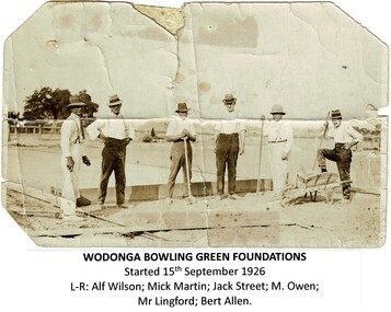
Photograph - Wodonga Bowling Club opening and History, Various
Wodonga Bowling Club was formally constituted in September 1925 . Percy Lingford was elected as the first president and Edward William Owens the first secretary. The site of the club was leased from the Shire Council for one shilling per annum. With the assistance of voluntary labour a four-rink green was laid and a pavilion. The club was officially opened by Percy Lingford on the 23 October 1926 The membership for the first year was 43 and the membership fee £2/2/0. At the first Annual General Meeting held in September 1926 Mick Martin was elected President, a position he held for the next 22 years. After catering for men's events over many years, and being permitted to play only socially, in 1949 the Ladies' (Associates) Section was formally constituted with Doll Connell the first president and May Hicks the first secretary. A surplus Army hut was purchased and moved in from Bonegilla and members converted it into a comfortable clubhouse. Over the years Wodonga has had many outstanding players who have won an array of association and group events and the club also has had a particularly high representation in group sides at both the district and State level. These items are significant because they document the establishment of a popular Wodonga sporting club.A collection of photos, programs and articles documenting the early development of the Wodonga Bowling Club.wodonga bowling club, albury-wodonga sport, wodonga community sports -
 Ballarat Tramway Museum
Memorabilia - Display Board with mounted signs, Graeme Sewell, 5/02/2004 12:00:00 AM
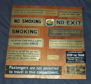
Varnished wooden panel fitted with 13 different tramway or railway related signs and one small image of a Melbourne Tramcar. The panel consists of two pieces of plywood glued to wooden backing boards. The signs have been fixed to the panel with brass screws - either round or countersunk. The signs are: "Passengers are not allowed in this Compartment / By-Law No. 5 Maximum Penalty - Five Pounds" "Passengers are requested to tender the EXACT FARE" "NO SMOKING" "NO EXIT" "SMOKING" "DESIGNED AND MANUFACTURED AT THE / TRAMWAYS BOARD'S WORKSHOPS / PRESTON" "TO STOP CAR PULL LEFT / HAND CORD ONCE" "Spitting in the car is STRICTLY PROHIBITED / Passengers infringing this Rule are liable to be ejected and prosecuted under the Board's By-law No. 5" "To stop car pull left hand cord ONCE / Entering or leaving this car from the wrong side is prohibited. Maximum penalty L5." "SPARE / CONTROLLER KEY" "In EXTREME DANGER / STOP THE TRAIN / by pulling CHAIN in this direction / Penalty for misuse L20" "Passengers are not permitted / to travel in this compartment." "RAILWAY MOTOR / TYPE GE 247-A / DL 2755000 SERIAL No. A2320 / AUSTRALIAN MANUFACTURE / AUSTRALIAN GENERAL ELECTRIC LIMITED / P.1022" L = pound symbol Signs collected by Graeme Sewell who assembled the Display Board during the 1980's.trams, tramways, signs, railways, tramways, passengers -
 Melbourne Tram Museum
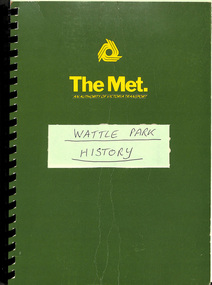
Document - Report, The Met, "Wattle Park", 1989
Report - approx. 90 A4 photocopied sheets, within a green cover preprinted for "The Met", titled "Wattle Park" containing many documents concerned with the history of Wattle Park and its status legally within a black comb binder. Comprises: 1 - Map 2 - two page letter from Tom Roper Minister for Planning and Environment to Jim Kennan Minister for Transport dated 22/11/1988. 3 - two page history 4 - two page extract from the Nov - Dec 1966 issue of MMTB News 5 - 23 pages - handwritten "Notes of Address on early history of Wattle Park given by A. J. Holt to the Box Hill Historical Society Nov. 1986. 6 - 10 page extract of the Act authorising the HTT to acquire the land and extracts from Hansard 7 - 4 page letter by the Office of the Solicitor to The Met Property department 1/12/1986 about the use of the land and charging fees for its use. 8 - 15 page legal advice re the use of the land and its permitted uses. 9 - 13 page follow up advice by P. N. Wikrama dated 20/6/1989 10 - 6 page photocopy of the certificates of title. Each section separated by a green sheet.trams, tramways, wattle park, legal agreements, htt, mmtb, the met, minister for transport -
 Bendigo Historical Society Inc.
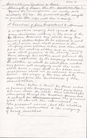
Document - ALBERT RICHARDSON COLLECTION: STRENGTH OF MINING ROPES, MINERS' CLOTHING
One page document 'Extract from Dickers Mining Record, Strength of ropes Vol.1, No. 5, March 1862, page 3, 'Square the circumference in inches, and multiply by 200. The product is the weight in pounds the rope will bear in safety' Also, 'A question of some importance to miners'. A co-operative company had agreed that every shareholder working in the mine of the Great Redan Extended Coy shall bring two suits of clothes before he be allowed to work in the mine and shall proceed to the shifting room allotted to him and then shall put on his working clothes and on leaving work shall proceed to the shanty, and there change his clothes, and permit the officer appointed by the company to search the clothes in which he shall have worked. Any person not complying with this rule shall have a man work in his place and such person shall not be allowed to go down below. The wages of the man shall be deducted from the dividends of the shareholder. When taken to court, his Honor ruled in Favour of the company. Each party to pay his own costs. He said that all classes when going through the Custon's Houses had to submit for the general good. It was not the individual in the present issue, but the clothes that were submitted to the indignity of being searched.bendigo, mining, strength of mining ropes -
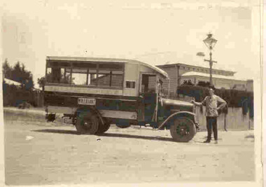 Ballarat Tramway Museum
Photograph - Black & White Photograph/s, late 1920's
Yields information about a vehicle the Electric Supply Co of Victoria used to provide additional services in Ballarat in the face of bus competition. See page 59 of Golden City and its Tramways for further information.Black and white photograph contained within Reg. Item 2488, page 55, of ESCo or Ballarat Tramways motor bus, with the destination of Mt. Pleasant on the side. Driver W. Irwin? Handwritten caption by H.P. James. Note Item Not formally Numbered. Image btm2507i2 shows position on page relative to items 2507 to 2512. For a copy photograph of this image, see Reg Item 3813. High Res Images added 15/3/2011. Digital scan of a negative in the Wal Jack Collection added 21/4/2019 as image btm2510i4Handwritten in Pencil under the photograph is "Here is an interesting picture. Note the driver he is W. Irwin who gave me these pictures for which I am very grateful. The bus petrol engine International type was formerly in the possession of, one, Cruickshanks, an independent driver with a permit from the council to run between The Point of Pictures?, Ness St, Mt Pleasant via Bond St, Peel St. to City but the Electric Supply Coy purchased the vehicle and ran it from 1927 to 1929 (unpayable). The most use it was put to was on Mt Pleasant, but it ran also to High School as replacement for trams on Sebas if an electric tram was derailed. Perhaps the most unique trips it ever made was between Forest St. Wendouree to the Aerodrome, 1929, on the occasions of any ?? flight. Again Mr Irwin was the driver (& made two trips)"tramways, trams, esco, motor buses, mt pleasant, cruickshanks -
 City of Moorabbin Historical Society (Operating the Box Cottage Museum)
Document, laminated List of Pioneers Moorabbin Parish, c1985
This list shows the names of the Pioneer settlers with the amount of Acres, the date purchased from The Crown and the Lot or Portion Number in the Land of the Henry Dendy Special Survey of Brighton 1841, in the County of Bourke , Victoria. The Squatters ,who arrived in the area first, used the land for grazing sheep and cattle. The Squatters had the right to graze unoccupied Crown land for ₤10 per year rental and a per capita payment for animals grazed. They could develop , improve and clear the land for the purpose of the tenancy but ownership was not permitted. When the land became useful The Crown put it on the market and the developers took over whilst the Squatters lost the improved land, dwellings and out buildings, there being no compensation paid. Squatters named John and Thomas Martin 1840-41; Richard and John King 1840- 1854 ; M.N.M.Moysey and M.J.Bickford 1841-1852 ; James McMahon 1846-1853 ; Daniel MacKinnon 1839- 1840. The 5120 Acres of the Henry Dendy Special Survey 1841were divided into approx. 83 Portions / Lots with varying acreage . Josiah Holloway, a speculator purchased 625 acres of the King Brothers run and re-sectioned the land into 2 acre Lots for Sale as market gardens. It was called The Two Acre Village later known as Cheltenham. A List of the names of The Pioneers in County of Burke Victoria c1841-1887 compiled by Lesley A. Schumer in 1985 A 3 Laminated display on wall in room 2 THE PIONEERS, Signed L.A. Schumer moorabbin, brighton, cheltenham, bentleigh, market gardeners, pioneers, early settlers, dendy henry, henry dendy's special survey 1841, squatters, king john, martin john, mcmahon james, two acre village, holloway josiah, were jonathan binn, grazing, cattle, sheep, market gardens, -
 Eltham District Historical Society Inc
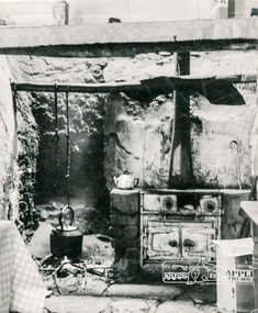
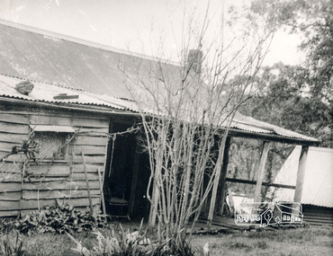
Photograph, George W. Bell, Birch Cottage, Yarra Glen Road, Smiths Gully, Aug 1969, Aug 1969
EDHS Newsletter No. 182, September 2008 In the late 1970s when our Society was the Shire of Eltham Historical Society, an offer was made to the Society regarding use of an old cottage at Christmas Hills. For various reasons the offer ultimately lapsed The cottage sat beside Watsons Creek just outside the then Shire of Eltham but following municipal restructuring it now lies within the Shire of Nillumbik. At that time some research on the cottage was carried out for the Society by Keith Chappel as part of a larger research project that he was doing. Keith's notes were taken from Lands Department records and showed that house is the subject of a permissive occupancy of Crown land comprising the creek reserve. In 1903 a Miners Right of one acre in area was granted to Edwin Samuel Birch. In 1907 Birch applied to purchase this land but was unable to because it was part of the creek reserve. The documents show that the house existed at that time. Birch died in 1932 and his daughter Honor Mary Birch was granted a permit to occupy the residence. The future of the cottage remains precarious because of its location on Crown land. In 2007 the Andrew Ross Museum began a campaign to ensure that it is preserved. It included a video presentation on the history of the cottage under the title of "This Old House- Birch Cottage". Black and white photographWilliams Cottage Panton Hill 1969 Not to be reproduced without permission G.W. Bell Photographer Elthamhouses, cottage, early settlers, yarra glen road, smiths gully, williams cottage, watsons creek, christmas hills, birch cottage, edwin samuel birch, honor mary birch -
 Eltham District Historical Society Inc
Photograph, George W. Bell, Detail, Kitchen, Birch Cottage, Yarra Glen Road, Smiths Gully, Aug 1969, Aug 1969
EDHS Newsletter No. 182, September 2008 In the late 1970s when our Society was the Shire of Eltham Historical Society, an offer was made to the Society regarding use of an old cottage at Christmas Hills. For various reasons the offer ultimately lapsed The cottage sat beside Watsons Creek just outside the then Shire of Eltham but following municipal restructuring it now lies within the Shire of Nillumbik. At that time some research on the cottage was carried out for the Society by Keith Chappel as part of a larger research project that he was doing. Keith's notes were taken from Lands Department records and showed that house is the subject of a permissive occupancy of Crown land comprising the creek reserve. In 1903 a Miners Right of one acre in area was granted to Edwin Samuel Birch. In 1907 Birch applied to purchase this land but was unable to because it was part of the creek reserve. The documents show that the house existed at that time. Birch died in 1932 and his daughter Honor Mary Birch was granted a permit to occupy the residence. The future of the cottage remains precarious because of its location on Crown land. In 2007 the Andrew Ross Museum began a campaign to ensure that it is preserved. It included a video presentation on the history of the cottage under the title of "This Old House- Birch Cottage". Black and white photographWilliams Cottage Panton Hill 1969 Not to be reproduced without permission G.W. Bell Photographer Elthamhouses, cottage, early settlers, yarra glen road, smiths gully, williams cottage, watsons creek, christmas hills, birch cottage, edwin samuel birch, honor mary birch -
 Eltham District Historical Society Inc
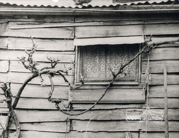
Photograph, George W. Bell, Detail, Cottage Entrance, Birch Cottage, Yarra Glen Road, Smiths Gully, Aug 1969, Aug 1969
EDHS Newsletter No. 182, September 2008 In the late 1970s when our Society was the Shire of Eltham Historical Society, an offer was made to the Society regarding use of an old cottage at Christmas Hills. For various reasons the offer ultimately lapsed The cottage sat beside Watsons Creek just outside the then Shire of Eltham but following municipal restructuring it now lies within the Shire of Nillumbik. At that time some research on the cottage was carried out for the Society by Keith Chappel as part of a larger research project that he was doing. Keith's notes were taken from Lands Department records and showed that house is the subject of a permissive occupancy of Crown land comprising the creek reserve. In 1903 a Miners Right of one acre in area was granted to Edwin Samuel Birch. In 1907 Birch applied to purchase this land but was unable to because it was part of the creek reserve. The documents show that the house existed at that time. Birch died in 1932 and his daughter Honor Mary Birch was granted a permit to occupy the residence. The future of the cottage remains precarious because of its location on Crown land. In 2007 the Andrew Ross Museum began a campaign to ensure that it is preserved. It included a video presentation on the history of the cottage under the title of "This Old House- Birch Cottage". Black and white photographDetail Cottage Entrance Williams Cottage Yarra Glen Rd Panton Hill Aug 1969 Photo - G.W.Bhouses, cottage, early settlers, yarra glen road, smiths gully, williams cottage, watsons creek, christmas hills, birch cottage, edwin samuel birch, honor mary birch -
 Eltham District Historical Society Inc
Photograph, George W. Bell, Detail, Front Wall, Birch Cottage, Yarra Glen Road, Smiths Gully, Aug 1969, Aug 1969
EDHS Newsletter No. 182, September 2008 In the late 1970s when our Society was the Shire of Eltham Historical Society, an offer was made to the Society regarding use of an old cottage at Christmas Hills. For various reasons the offer ultimately lapsed The cottage sat beside Watsons Creek just outside the then Shire of Eltham but following municipal restructuring it now lies within the Shire of Nillumbik. At that time some research on the cottage was carried out for the Society by Keith Chappel as part of a larger research project that he was doing. Keith's notes were taken from Lands Department records and showed that house is the subject of a permissive occupancy of Crown land comprising the creek reserve. In 1903 a Miners Right of one acre in area was granted to Edwin Samuel Birch. In 1907 Birch applied to purchase this land but was unable to because it was part of the creek reserve. The documents show that the house existed at that time. Birch died in 1932 and his daughter Honor Mary Birch was granted a permit to occupy the residence. The future of the cottage remains precarious because of its location on Crown land. In 2007 the Andrew Ross Museum began a campaign to ensure that it is preserved. It included a video presentation on the history of the cottage under the title of "This Old House- Birch Cottage". Black and white photographDetail of Front Wall Williams Cottage Yarra Glen Rd Panton Hill Aug 1969 Photo - G.W.Bhouses, cottage, early settlers, yarra glen road, smiths gully, williams cottage, watsons creek, christmas hills, birch cottage, edwin samuel birch, honor mary birch -
 Eltham District Historical Society Inc
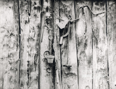
Photograph, George W. Bell, Detail, Shed Wall, Birch Cottage, Yarra Glen Road, Smiths Gully, Aug 1969, Aug 1969
EDHS Newsletter No. 182, September 2008 In the late 1970s when our Society was the Shire of Eltham Historical Society, an offer was made to the Society regarding use of an old cottage at Christmas Hills. For various reasons the offer ultimately lapsed The cottage sat beside Watsons Creek just outside the then Shire of Eltham but following municipal restructuring it now lies within the Shire of Nillumbik. At that time some research on the cottage was carried out for the Society by Keith Chappel as part of a larger research project that he was doing. Keith's notes were taken from Lands Department records and showed that house is the subject of a permissive occupancy of Crown land comprising the creek reserve. In 1903 a Miners Right of one acre in area was granted to Edwin Samuel Birch. In 1907 Birch applied to purchase this land but was unable to because it was part of the creek reserve. The documents show that the house existed at that time. Birch died in 1932 and his daughter Honor Mary Birch was granted a permit to occupy the residence. The future of the cottage remains precarious because of its location on Crown land. In 2007 the Andrew Ross Museum began a campaign to ensure that it is preserved. It included a video presentation on the history of the cottage under the title of "This Old House- Birch Cottage". Black and white photographDetail of Shed Wall Williams Cottage Yarra Glen Rd Panton Hill Aug 1969 Photo - G.W.Bhouses, cottage, early settlers, yarra glen road, smiths gully, williams cottage, watsons creek, christmas hills, birch cottage, edwin samuel birch, honor mary birch -
 Eltham District Historical Society Inc
Photograph, Liz Pidgeon, Heritage Excursion; The 1901 Eltham Railway Walk, 3 May 2014, 3 May 2014
Newsletter No. 216, May 2014 May Excursion – The 1901 Eltham Railway Walk The railway from Heidelberg to Eltham was opened in 1902. Over the previous year railway construction cut a curving swathe through Josiah Holloway’s 1851 Little Eltham subdivision. The survey plans for the railway show the owners and occupiers of land within Little Eltham affected by the railway alignment and for some distance each side. The plans show houses and other buildings but development at that time was rather sparse. Copies of these plans from the State Library of Victoria collection have been provided to the Society by Alan Sheehan. For our walk on 3rd May we intend to follow the railway from the Eltham Station to Ryans Road, which was the boundary of the adjoining Montmorency Farm. The return will be by way of nearby streets. Along the way we will discuss the details shown on the railway plans as well as more recent railway documents and photographs. At the conclusion and if time permits we can inspect the historical display at the Eltham Station. The walk is about 3 km in length and will take about 2.5 hours. It will start at 2 pm at the Eltham Railway Station car park (east/Main Road side) (Melway Ref. 21 J5).Born Digitalheritage excursion, activities, eltham district historical society, eltham railway station, eltham library, trestle bridge -
 Eltham District Historical Society Inc
Photograph, Liz Pidgeon, Heritage Excursion; The 1901 Eltham Railway Walk, 3 May 2014, 3 May 2014
Newsletter No. 216, May 2014 May Excursion – The 1901 Eltham Railway Walk The railway from Heidelberg to Eltham was opened in 1902. Over the previous year railway construction cut a curving swathe through Josiah Holloway’s 1851 Little Eltham subdivision. The survey plans for the railway show the owners and occupiers of land within Little Eltham affected by the railway alignment and for some distance each side. The plans show houses and other buildings but development at that time was rather sparse. Copies of these plans from the State Library of Victoria collection have been provided to the Society by Alan Sheehan. For our walk on 3rd May we intend to follow the railway from the Eltham Station to Ryans Road, which was the boundary of the adjoining Montmorency Farm. The return will be by way of nearby streets. Along the way we will discuss the details shown on the railway plans as well as more recent railway documents and photographs. At the conclusion and if time permits we can inspect the historical display at the Eltham Station. The walk is about 3 km in length and will take about 2.5 hours. It will start at 2 pm at the Eltham Railway Station car park (east/Main Road side) (Melway Ref. 21 J5).Born Digitalheritage excursion, activities, eltham district historical society, eltham railway station, eltham library, trestle bridge