Showing 1330 items matching "population"
-
 Ballarat Tramway Museum
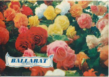
Postcard - Folder set, Nu-color-vue or Nucolorvue Productions, "Ballarat The Begonia City"
Published by Nucolorvue Productions, Mentone, Victoria. Inside the folder is a printed note on Ballarat, with a note that it was just embarking on its second century, and has a population of 40,000 people. Printed c1955. Inside the folder was a two sided strip of 12 photos, that was glued to the folder. Features photos of the Botanic Gardens, Eureka stockade, floral clock in Sturt St, a view from the Town Hall with a tram parked in the City Loop, Civic Hall, the crown at Shell House, Sturt St at Lydiard St with a tram parked at the City centre and the Arch of Victory. See item 9120 for another similar production.Demonstrates a postcard folder produced by Nucolorvue.Printed colour postcard folder titled "Ballarat The Begonia City", featuring a photo of begonias on the cover and an address box on the rear of the folder. trams, tramways, sturt st, postcards, gardens, lake wendouree, begonia -
 Surrey Hills Historical Society Collection
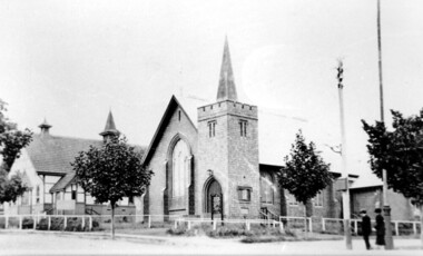
Photograph, Holy Trinity Church of England, Surrey Hills post 1926, After 1926
St George's Church of England, Mont Albert was built in 1886 and from 1904 until 1907 was known as Holy Trinity, Surrey Hills. As the population increased there was a need for a church in Surrey Hills. This brick church was consecrated in 1922 and replaced the earlier one built in 1907 on the adjacent site in Union Road. After construction of the brick church, the earlier one became a Sunday School. The copper spire was added in 1926, which dates this photo as post-1926. Norman Carter took many photos of Surrey Hills and Mont Albert in the 1920s; many were associated with events and activities of the Church of England.Black and white photo of the 'newly' constructed brick Holy Trinity Church in Union Road, Surrey Hills taken from near the south-west corner of Guildford Road. Further up the hill is the earlier church. Both buildings are bounded by a simple post and rail fence. Immature street trees are planted on both sides of Union Road.churches, holy trinity church, anglican church, sunday schools, norman carter -
 Melton City Libraries
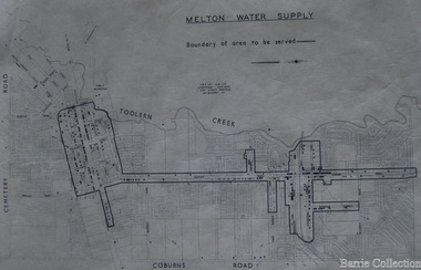
Map, Melton Water Supply, Unknown
The development that had arguably the greatest impact in encouraging population growth in the shire during this period, was the establishment of a reliable water supply for the district. This had been a major concern of the local community for over 100 years, since the Melton township was first founded. Despite various schemes over the years to create a reliable water supply, the district was still dependent on bores, wells and tanks when the Melton Waterworks Trust was established in 1961 to address Melton’s water woes. With the opening of the Djerriwarrh Dam in December 1963, the shire’s residents finally had access to a reticulated water supply.Map shows the boundary of the area where the water will be serviced in the towncouncil -
 Orbost & District Historical Society
black and white photograph, C1910
the Orbost State School opened on19th of March 1886. The school had first operated temporarily in a leased building, and on a half-time basis with SS2745 Jarrahmond, The head teacher was Campbell Mackay who remained in charge only until 12th of May 1886. The second head teacher, John Rowe, served until 1908. On 30th of June 1887, a portable room was provided; it being brought to the area by schooner. The school now had accommodation for 30 pupils; the teacher's welfare was considered because quarters of two rooms were attached. As the population increased so did the needs of the school. This was reflected in the provision of a larger classroom in 1898. During 1910-11 the first approaches were made to the Department for the establishment of a Higher Elementary School in Orbost and this became a reality in 1912. Orbost. The Higher Elementary School supplied post-primary education in the district until a high school was built in 1948. When fire destroyed the school in 1941 local halls were used as classrooms until a new school was built, opened by the Hon. A. E. Lind, MLA, on 13th of February 1942. But Orbost continued to develop and the new school was soon overtaxed. This resulted in the erection of two Bristol classrooms in 1947. By 1950, when the school population had reached 500 pupils the opening of the new school at Orbost North was welcomed by all concerned. In 1963 the Department purchased land diagonally opposite the school and developed it as a playing area.This item is associated with education in the Orbost district.A black / white photograph of a large school building with two men standing out the front.orbost-state-school education-orbost -
 Cockatoo History & Heritage Group
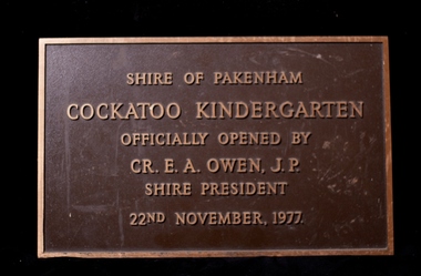
Plaque, Cockatoo Kindergarten - Official Opening Plaque
In 1977 residents of Cockatoo built a kindergarten in McBride Street Cockatoo to service the growing population in the area. The building was officially opened on the 22nd of November of that year. Residents formed a Co-op, raised all the money to build the kinder along with lawn bowls and tennis sporting facilities for the town. No small feat, let alone for a town with a population of around 3000. The land was provided by the council for the kinder to use and that was their sole contribution to the building of the kinder. The unique building, was designed by Richard Allen and depicted a children's carousel. The design was to provide a feeling of enjoyment and friendship to the children who used the building. The large glass windows that were installed on the north-eastern side of the building made up 1/3 of the exterior wall. This overlooked the playground of the kinder making it easy to see the children at play from inside. The site of the building is in a dominant position and is highly visible to all who travel through Cockatoo. It was used as a child care facility right up until 2005. The kindergarten has recently been granted heritage listing after Cardinia Council started demolishing the building. The local community were successful in putting a halt to the demolition and saved the building. It will become an integral part of the Cockatoo Ash Wednesday memorial. Details on the fight to save the kinder building can be found at https://sites.google.com/site/cockatoosheritageashwednesday/ Brass Plaque, depicting the opening of the Cockatoo Kindergarten by the Shire of Pakenham Shire President - Cr OwenShire of Pakenham Cockatoo Kindergarten Officially Opened by Cr E A Owen J.P Shire President 22nd November 1977cockatoo, kindergarten opening, -
 Wooragee Landcare Group
Photograph, 28th April 2004
Wooragee Landcare was formed in 1989 to promote sustainable conservation and land-use practices in the North-East region of Victoria. The organisation's work has included public awareness and education campaigns to control invasive, introduced species and protect native wildlife, such as campaigns to bait or trap foxes and to identify and monitor quoll populations in the region. The organisation has drawn on the work of a variety of Government and academic experts to inform best practice approaches are utilised. In 2004 Andrew Murray, a leading quoll expert from Parks Victoria, conducted training for Wooragee Landcare members and the local community in how to identify potential quoll habitat and populations (through identifying scat and other methods). Spotted-tail or Tiger quolls were known to have lived in the Mt Pilot and Stanley Plateau region previously but habitat encroachment, competitor species such as foxes and natural disasters had reduced sightings in recent years. The Spotted-Tail quoll (formerly known as the Tiger Quoll) is the largest of four species of native marsupial carnivore on mainland Australia, and the second-largest carnivore (after the dingo). The species' scientific name, Dasyurus maculatus, references its' 'hairy tail'. Adults are approximately 125cm long, including their long tail, and weigh around 5 kilograms. The Spotted-tail quoll is currently considered to be a threatened species, but other species are currently listed as endangered.This photograph is significant as an example of wildlife protection awareness programs undertaken by Wooragee Landcare Group in the 2000s in Indigo Shire.Landscape coloured photograph printed on gloss paper.Reverse: WAN NA 0ANA2N0 NNN+ 1 8743 / [PRINTED] (No.23) / 269wooragee, wooragee landcare, indigo shire, north-east victoria, andrew murray, queries about quolls, wildlife, conservation, farming, predators, spotted tail quolls, quolls, marsupials, south-east forests, mt pilot, stanley plateau -
 Wooragee Landcare Group
Photograph, 28th April 2004
Wooragee Landcare was formed in 1989 to promote sustainable conservation and land-use practices in the North-East region of Victoria. The organisation's work has included public awareness and education campaigns to control invasive, introduced species and protect native wildlife, such as campaigns to bait or trap foxes and to identify and monitor quoll populations in the region. The organisation has drawn on the work of a variety of Government and academic experts to inform best practice approaches are utilised. In 2004 Andrew Murray, a leading quoll expert from Parks Victoria, conducted training for Wooragee Landcare members and the local community in how to identify potential quoll habitat and populations (through identifying scat and other methods). Spotted-tail or Tiger quolls were known to have lived in the Mt Pilot and Stanley Plateau region previously but habitat encroachment, competitor species such as foxes and natural disasters had reduced sightings in recent years. The Spotted-Tail quoll (formerly known as the Tiger Quoll) is the largest of four species of native marsupial carnivore on mainland Australia, and the second-largest carnivore (after the dingo). The species' scientific name, Dasyurus maculatus, references its' 'hairy tail'. Adults are approximately 125cm long, including their long tail, and weigh around 5 kilograms. The Spotted-tail quoll is currently considered to be a threatened species, but other species are currently listed as endangered. This photograph is significant as an example of wildlife protection awareness programs undertaken by Wooragee Landcare Group in the 2000s in Indigo Shire.Landscape coloured photograph printed on gloss paper.Reverse: WAN NA 0ANA2N0 NNN+ 2 8743 / [PRINTED] (No.22) / 268wooragee, wooragee landcare, kiewa landcare, indigo shire, north-east victoria, farming, conservation, wildlife, quoll, quolls, marsupials, predators, simon feillafe, andy murray, south-east forests, spotted tail quoll, mt pilot, stanley plateau, andrew murray -
 Kiewa Valley Historical Society
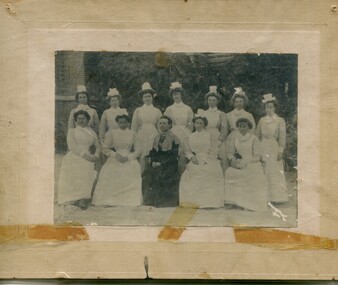
Photographs – Group of 3 old sepia photographs, 2 of women in period costume and 1 of group of nurses from Sunbury sanatorium
Europeans arrived in the Kiewa Valley in the 1830s and 40s. Following the drought of 1838-44 seeking out the rich pastures in the fertile Kiewa Valley. . The next major increase in population was as a result of the Kiewa Hydro Scheme. The beginning of construction of the Kiewa Hydro-electric scheme in the late 1940s introduced changes and led to the enlargement and improvement of local roads and the townships of Mount Beauty and Bogong Village were constructed by the SECV from the 1930’s to the 1950’s to house workers on the Kiewa Hydro Electric Scheme. At its peak the Kiewa Scheme employed around 4000 people from all walks of life and as many cultures.The influx of European migrants to work on the Hydro Scheme along with their rich cultural backgrounds, all played a major part in establishing the history of the area and in shaping the future character of the Mount Beauty, the Kiewa Valley and Falls Creek areas. Photographs may depict descendants, family or friends of early settlers or workers in the Kiewa Valley region.1. Sepia photograph, mounted on heavy buff card with yellowing marks from sticking tape across the bottom of the photograph. Photograph is of a group of nurses taken at the Sunbury Sanitorium 2. Sepia photograph mounted on heavy buff card with yellowing marks from sticking tape at top and bottom of photo. Mark from drawing pin in centre top of photo. Photograph is of a middle aged woman posing dressed in period costume 3. Sepia photograph mounted on heavy buff card with yellowing marks from sticking tape at top and bottom of photo. Mark from drawing pin in centre top of photo. Photograph is of an older woman posing dressed in period costume sepia photos; nurses; kiewa valley; sunbury sanitorium; period costume -
 Federation University Historical Collection
Photograph, Delegates to the ANA Conference, 1947, 21/03/1947
Dysart is a Tudor Gothic building used as the original site of Geelong Grammar School. The Governor of Victoria, Sir Henry Barkly, laid its foundation stone in 1857 with the Bishop of Melbourne and the Archdeacon of Geelong in attendance. The student boarder population grew rapidly to call 55 Maud Street their home. After the school relocated to a larger site in 1914, the building was subdivided into a factory and a guesthouse called the Dysart Private Hotel. In 1961, it was again converted into the Reformed Theological College then later a private residence. In 2018 55 Maud Street had fallen into a state of disrepair, but was renovated to provide 28 premium dormitories in a peaceful and gorgeous setting.Small black and white photo.Verso "Taken oustise "Dysart" 21-3-47 Delegates ANA Conference 1947 Geelongana, australian natives association, geelong, dysart -
 Orbost & District Historical Society
book, Hepburn, Dorothy, State School Number 3267 Lower Bendoc East Gippsland Victoria, C 2002
Located near the NSW border in the far east of Victoria, the Bendoc school served the needs of a rural population which opened the land to grazing at the turn of the century. It opened on September 8 1896. In December 1956 falling attendances forced the Education Department to close it. It is interesting to note that children here sought their secondary education in NSW. The first head teacher) was John M. Cass and the last R R King. In 1953-54 Lower Bendoc operated part-time with Goongerah. In 1955 it regained full-time status, but in 1956 worked part-time with Tubbut. Author, Dorothy Hepburn, attended Bendoc State School.This is a useful reference tool on the history of Bendoc.A spiral bound book with a plastic sheet front. The cover is white with black print and a b/w photo of a man sitting on a wooden chair outside a log building . Underneath is written "FROM HUMBLE BEGINNINGS TO FINAL CLOSURE".bendoc-state-school -
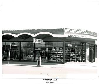 Wodonga & District Historical Society Inc
Photograph - Codling Collection 01 - Wodonga Mall and construction
Miss Olive Codling was a Foundation Member and a Life Member of the Wodonga Historical Society. Many of her prize-winning photos are held in the Society Collection. She also held a range of roles and committee positions in a wide range of Wodonga community organisations. These included the Horticultural Society, the Wodonga Arts Council, the Wodonga Camera Club and the Wodonga Lapidary Club. As the population of Wodonga grew in the late 1960s and 1970s, development focussed on the central section of High Street. The Wodonga Mall was built in 1969 on the corner of Stanley and High Streets in Wodonga and was the location of a variety of small businesses including a chemist and Sarroff's Dry Cleaners.This photo collection is significant as it documents how the businesses and buildings in Wodonga have evolved and contributed to the community throughout the 20th century. A series of 3 black and white photos showing the development of the Wodonga Mallwodonga businesses, high st wodonga, melba theatre -
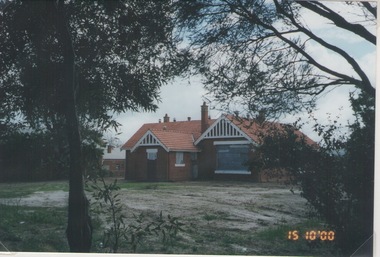 Sunbury Family History and Heritage Society Inc.
Photograph, Rosa McCall, Former Sunbury State School, 15th October 2000
The photograph was included in an exhibition organised by the former Sunbury & District Heritage Association in March 2001. The red-brick Federation building for Sunbury State School No. 1002 in Macedon Street opened on 2nd May 1912. It replaced an earlier building that was on the same site. It originally had two classrooms and an office but as Sunbury's population began to grow another room was added. The school continued to function in Macedon Street until 1999 when it took occupancy of refurbished rooms at the former Industrial School in the Asylum Grounds at Jascksons Hill. The building in Macedon Street has been incorporated into the Sunbury and Cobar Community Health Centre. The red-brick Federation Style Sunbury building has served the educational needs of the Sunbury Community for 112 years as it is now an Educational facility for people with disabilities.A non-digital coloured photograph go a red-brick federation school building with cream trims around the windows and doors.Two trees are growing in the foreground.sunbury state school no. 1002, macedon street, education, schools -
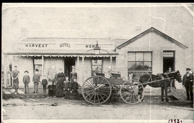 Bacchus Marsh & District Historical Society
Photograph, Harvest Home Hotel Main Street Bacchus Marsh c.1880s-1890s
The Harvest Home Hotel was licensed as a beer shop in 1866. Patrick Vallence was the licensee. On his death in 1874 his widow Mrs M. A. Vallence obtained the license. The date that this image was created has not been identified. Around 1883 George Marshall was leasing the hotel. The people in this image are could be members of the Marshall family and some of the staff who worked in the hotel at this time. Following a decrease in the population of Bacchus Marsh by 1911 the hotel had lost its licence. The Vallence family still owned the building after the loss of the hotel license in 1911and it was used for some years after this as a private residence by some members of the Vallence family. Small black and white photograph. The image depicts the Harvest Home Hotel situated in Main Street Bacchus Marsh. The name of the hotel can be seen above the verandah roof. The building appears to be of stone with decorative stonework corners. A verandah is inset to the left of a gabled front section which has its own door and window. A deep gutter runs along the front of the hotel, with a slab acting as a bridge to the road. Standing in front of the building facing the camera is a group of adults and children, men and women and boys and girls. A four seated buggy drawn by a single horse is also present in the image. The lantern erected above the horse trough can be seen.hotels bacchus marsh, vallence family bacchus marsh, marshall family bacchus marsh, harvest home hotel bacchus marsh -
 Narre Warren and District Family History Group
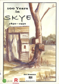
Book, Dot Morrison, 100 years in Skye 1850-1950, 2004
The book 100 Years in Skye, 1850-1950 by Dot Morrison explores the history of Skye in a detailed account of the area's development over a century, including its social, economic, and cultural changes. The book's illustrations, maps, and photographs offer a vivid portrayal of life in Skye during this period. Includes an index and bibliography.99 p.; 29 cmnon-fictionThe book 100 Years in Skye, 1850-1950 by Dot Morrison explores the history of Skye in a detailed account of the area's development over a century, including its social, economic, and cultural changes. The book's illustrations, maps, and photographs offer a vivid portrayal of life in Skye during this period. Includes an index and bibliography.skye (vic.), skye (vic.) -- history, skye (vic.) -- road names, wedge family, skye (vic.) -- murders, south lyndhurst state school -
 Narre Warren and District Family History Group
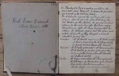
Book - Narre Warren North Red Cross Minute Books 1939 to 1964, Narre Warren North Red Cross, 1939-1964
Narre Warren North had a population of 200 in 1933. Just a month after World War 2 began in September 1939, a meeting was held in the Narre Warren Scout Hall to discuss the formation of a branch of the Red Cross Society. Mrs Harry Randle was elected president, Mrs Montague, vice president; Mrs Brundrett, secretary and Mrs Ewart, treasurer. All financial members were deemed to constitute the committee. By 1953, just 14 years after their formation they had raised over two thousand pounds, of which one thousand, eight hundred and eighty-two pounds had been sent to headquarters.The minutes bring together the ladies of all walks of life in a small rural community. The early minutes reflect the difficulties of the war years when many of the women may have had husbands, sons and daughters in the services. Despite rationing and shortages of materials these ladies always seemed to have most of what they needed to make goods to sell at stalls, provide suppers at concerts and social afternoons and hold an annual fair. In their spare time they knitted socks and helmets and sewed pyjamas that were sent to those serving overseas. The minutes highlight the work of our local women and give us an insight into the often unrecorded contributions women made within their communities in a time when local histories were dominated by male achievements.Six exercise books bound with hard cover binding. Navy blue debossed cover.narre warren north (vic.), narre warren north (vic.) -- red cross, red cross society -
 Warrnambool and District Historical Society Inc.
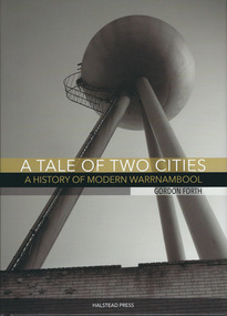
Book, A tale of two cities: a History of Modern Warrnambool, 2015
This book is the story of modern Warrnambool, describing aspects of the city from the 1980s to 2015. It looks at such topics as religion, law, population, housing, infrastructure, employment, industry, health, education and politics. The author, Gordon Forth, was formerly a lecturer in the Faculties of Education and Arts and the Director of the Centre for Regional Development at Deakin University in Warrnambool. He has written and edited a number of books dealing with Warrnambool and district history. Mark Rashleigh, responsible for the design and lay-out of the book and many of the photographs, was a lecturer in visual communication and graphic design in the Faculty of Arts at Deakin University and is now involved with the Warrnambool and District Historical Society in the preparation and cataloguing of historical photographs.The book is of some importance as it is the only comprehensive study of Warrnambool over the past 30 years and complements ‘By These We Flourish’, the story of Warrnambool’s people, places and events up to the 1980s. It is will be of great interest to readers in general and researchers in particularThis is a hardcover book of 320 pages. The dust cover is multi-coloured (black, white and gold) with an image of the water tower at the former Fletcher Jones Factory site on the front cover and an image of the Warrnambool Breakwater on the back cover. The hard cover book has the same colouring and images as the dust cover.Front covers – ‘A Tale of Two Cities – A History of Modern Warrnambool’, ‘Gordon Forth’, ‘Halstead Press’ Spines – ‘A Tale of Two Cities – A History of Modern Warrnambool’, ‘Forth’, ‘Halstead’ Back Covers – ISBN number and code warrnambool, gordon forth, a history of modern warrnambool, a tale of two cities -
 Federation University Historical Collection
Report, Concept and Market Study for the Development of a Time Tunnel in Hamilton
Report compiled by six students of Tourism at University of Ballarat (later Federation University Australia)victorian tourisim industry, tourism, hamilton, time tunnel, population, agricultural history, ansett, aviation, reginald hamilton, aboriginal, mount eccles, dhauwurd wurrung, gundidjmara, lake condah, lutheran, german, tarrington, tetrapods -
Mortlake and District Historical Society
Mt. Shadwell Bush Inn, photograph
This Mount Shadwell Bush Inn erected in 1854 was situated adjacent to one of the main routes to the diggings (Great Western Road), and was originally built from tufa stone obtained from a local quarry. It did a great trade after if first became licensed ub 1855, when it provided a valuable service to the travelling public and to the increasing agricultural population of the area. At that time it contained three sitting rooms, several large reception rooms, fourteen bedrooms, a bar and two taprooms and was the first known hostelry in Mortlake. In 1863 a bluestone addition (probably done by local architect Andrew Kerr) increased the size of the hotel to 23 rooms with a detached billiard room and ballroom, kitchen, servant's apartments, laundry, storeroom, 12 stalled stable, out office, and stock yards for travelling cattle. The present hotel with its 1928 rendered facade, has had an almost uninterrupted licence since 1855 -
 Bendigo Historical Society Inc.
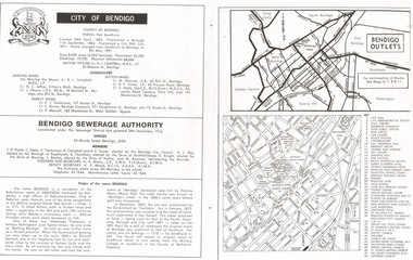
Document - LONG GULLY HISTORY GROUP COLLECTION: CITY OF BENDIGO
Page with the titled City of Bendigo includes when the County was created, proclaimed a Borough, then a City and a name change, the area, population, swellings and Mayoral Allowance. Darling Ward Councillors were: Cr R L Campbell, The Mayor, Cr N C Jeffrey, and Cr J Pearce. Sutton Ward Councillors, Cr M Petersen, Cr R F Turner, and Cr C Stoltz. and Barkly Ward Councillors, Cr P T Tomkinson, Cr C Davies and Cr P Mansell. Bendigo Sewerage Authority Members: T R Flood, C Stoltz, P Tomkinson, R Campbell, R F Turner, A L Roy, K Houlahan, E Knight, J Bowles, M Brennan, H A Moors and V F Moyle. Also mentioned is the Origin of the name Bendigo. There is a small map of Bendigo Outlet roads and another map with services, attractions, churches, etc.bendigo, history, long gully history group, the long gully history group - city of bendigo, cr r l campbell, cr n c jeffrey, cr j pearce, cr m petersen, cr r f turner, cr c stoltz, cr p t tomkinson, cr c davies, bendigo disposals, cr p mansell, bendigo sewerage authority, t r flood, bendigo city council, a l roy, borough of eaglehawk, k houlahan, shire of strathfieldsaye, e knight, shire of marong, j bowles, shire of huntly, m brennan, h a moors, v f moyle, abednego, john wesley, abednego thompson, battling bendigo, richard sherratt, thomas myers, castleton, sandhurst, military college of sandhurst england -
 Bendigo Historical Society Inc.
Document - NOTED EVENTS, c1970
Document. Two pages typed, timelined document on noted events in the Bendigo District, 1839 - 1891. Prepared by the Bendigo Branch of the Royal Historical Society of Victoria. Mentions Mr Charles Sherratt, Grice and Heape (licenced squatters of Mt. Alexander sheep run, later called Ravenswood), Mrs John Kennedy & Mrs Patrick P Farrell. 'Bendigo's Creek' named after Thomas Myer, Mr J A Paton (Resident Commissioner), Mr Lachlan McLachlan (Police Magistrate), First Bendigo Advertiser printed 9 Dec. 1853, Bendigo 1854 Census - 15,480 and 4,000 Chinese, E. J. Ennor, Sandhurst Fire Brigade, A. Lloyd - Inspector Cattle Yards, Cr. W. V. Simons, J. Mouat - Chairman Eaglehawk Council, Cr. Joh;n McIntyre. Sandhurst proclaimed a city on 21 July 1871, 1881 population of Bendigo - 14,577, 18 May 1891 - name of Bendigo was once again proclaimed.cottage, miners, noted events, bendigo census, bendigo advertiser, cattle yards, sandhurst proclaimed a city -
 Wangaratta Historical Society
Wangaratta Historical Society
The Wangaratta Historical Society Inc. (WHS) was established in 1959 and moved into its present home in the 1970s. Wangaratta in North East Victoria has a population of over 27 thousand people and is situated at the junction of the King and the Ovens Rivers. Agriculture has always been a big part of its history as well as education, health and manufacturing. The museum was originally a fire station built 1895 and included living quarters for its staff. The building is owned by the Rural City of Wangaratta who are great supporters of the WHS The museum was bequeathed 10,000 glass negatives from the late 1800s to the 1950s these were by the Vine & Thelma studios of mostly, portraits, weddings and historical photos. Also owned by the WHS is the Maianne Gibson crazy patchwork quilt made by a Wangaratta woman in the 1890s and now Heritage listed. This Quilt is housed in an specially controlled conditions. The Wangaratta Historical Society Museum was accredited in 2012 under the Museums Accreditation Program. -
 Bendigo Historical Society Inc.
Slide - DIGGERS & MINING. GETTING THE GOLD, c1850s
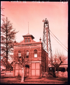
Diggers & Mining. Getting the Gold. Slide: MEMS FROM THE MOUNT - But in spite of all these wonderful golden discoveries, day after day, the grand desideratum is wanting - water, and with the amazing population rushing into these fields. I am surely afraid of very serious consequences arising . . . . As much as 30s. a barrel is now being paid I some of these gullies for water, and the price is likely to increase. Near to every tent you will see great heaps of washing stuff up, waiting for the first rains; one friend of mine has 400 cartloads this piled up, which he calculates will yield about 3 ounces to the load, and he and his mates still keep adding to their monstrous heap. (M.M.H., June 14, 1853.) . . .while others would spend the dry weeks heaping up ''stuff'' to be treated when the stream flowed again Markings: 68 994.LIF:4. Used as a teaching aid.hanimounteducation, tertiary, goldfields -
 Warrnambool and District Historical Society Inc.
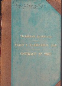
Document - Victorian Railways. Koroit & Warrnambool Line. Contract No. 2937, Circa 1888
The Victorian Railways began in 1854 and in the first 14 years up to 1868 had managed to complete about 250 miles of track. The next 60 years saw the system expand to nearly 3000 miles. By 1931 every town with a population over 500 had its own railway station. Early Victorian railway maps indicate that the extension from Colac to Warrnambool and then onwards to Koroit, occurred in the period of the 1880’s when the act known as the Octopus act saw a rapid expansion of lines. At the time there was much debate over where the expansion of the lines should take place, with one of the prime considerations for Warrnambool was the impact it would have on its port.The building of the railway to Warrnambool and onward to Koroit was a significant event for the town. Green cloth cover with tan suede corner points and spine. Title printed in gold on front cover. Title printed in gold on red on spine. 92 pages. The contract is printed and includes handwritten entries with specifications.Handwritten on front cover and inside front cover ” Copy for Engr in Chief” .On Page 2 transferred to Allan Reid * 24/1/88 Co Briscoe & Co Little Collins Street, Melbourne.warrnambool, railways, warrnambool to koroit railway, victorian railways contract no 2937 -
 Melbourne Water
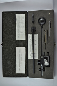
Compensating Polar Planimeter, c.1970s
As the Yarra became unsuitable as a source of water, several attempts were made to find alternative sources for the growing population of Melbourne. It was not until 1891 that the efforts to sewer Melbourne came to fruition with the setting up of the Melbourne Metropolitan Board of Works (MMBW), now known as Melbourne Water. From 1891 until 1992, it was the responsibility of the MMBW to safeguard public health by providing a sewerage system and a safe water supply system. In 1992, The MMBW merged with a number of smaller urban water authorities to form Melbourne Water. This item was used by MMBW employees as a measuring device to determine areas or figures on a plane surface having either straight or irregular boundaries. The Compensating Polar Planimeter is of historical significance for its association with the former Melbourne and Metropolitan Board of Works (MMBW). This measuring device is perfectly intact and a rare surviving object of standard Board issued equipment. The kit is significant for its representativeness of the theme of Technology in building Victoria's industries and workforce, which continues to resonate strongly within Melbourne Water today.The instrument is inside a black metal case with accessories including: Setting bar, screwdriver, Allen key and spare pole point. Inside is also the adjustable planimeter. mmbw, melbourne water, melbourne metropolitan board of works, technology, instrument, work, measure, historic, water, staff -
 Surrey Hills Historical Society Collection
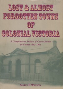
Book, Lost and almost forgotten towns of colonial Victoria: a comprehensive analysis of census results for Victoria, 1841 - 1901, 2003
Purchased from the author when he spoke at a meeting of the Surrey Hills Historical Society. This meticulously researched book lists all towns and villages with entries in the Victorian censuses between 1841 and 1901. There are over 1400 entries. It includes the latitude and longitude for each town. It indicates how many males and females lived in the town, and the number of occupied dwellings (where available). For many of these settlements the only visible trace of them today is in the census results collected by the fledgling governments of Colonial Victoria. It is a comprehensive reference and a fascinating insight into the movements of early populations of new Australians and the forces that shaped them and is useful to historians, researchers and all readers with a fascination for colonial history.This book lists all the towns and villages with entries in Victorian censuses between 1841 and 1901. There are over 1400 entries. 518pp, with place name index. cities and towns, ghost towns, victoria, 1841, 1901, angus b watson -
 Bendigo Historical Society Inc.
Document - Notes on St Andrews Church Axedale, 1st Sept 2024
Although Presbyterians held religious services prior to 1854 it, was not till that year that Dr Nish arrived in Bendigo. It is known that Dr Nish preached to the shepherds in Axedale, long before the church was built, but where is not known. The foundation stone for the church was lain on September 30th, 1868. Axedale is a town in Victoria, Australia. It is located on the McIvor Highway, in the City of Greater Bendigo, east of Bendigo. It was surveyed and proclaimed in 1861. At the 2021 census, Axedale had a population of 984. The town is nestled alongside the Campaspe River which feeds out of Lake Eppalock. It has a golf course, tennis courts, a school, a pub and a convenience store/petrol station. It lies between Heathcote and Bendigo.Historical Notes on St Andrews Axedale 1868-1968 and the 150th Anniversary Church booklet March 2019.axedale, st andrews church axedale, dr nish -
 The Beechworth Burke Museum
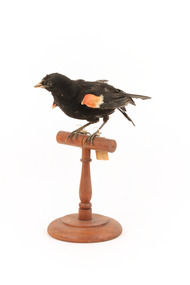
Animal specimen - Red-Winged Blackbird, Trustees of the Australian Museum, 1860-1880
The red-winged blackbird is native to North America. They live in a verity of places from southern Alaska at its northern most point, to the Yucatan peninsula in the south and covers the greater part of the continent reaching from the Pacific coast of California and Canada to the eastern seaboard. Populations that are most northerly migrate south after the mating season, but some of the populations in the central and western United States, Central America and the Gulf Coast are resident year-round. In the breeding season, Red-winged blackbirds are found in a range of fresh and saltwater environments, including in small trees and bushes along marshes and watercourses, in agricultural areas and dry meadows. During migration, they can be found in, pastures, prairies and cultivated fields. They are polygamous. The Red-winged blackbirds are known for their scarlet and yellow shoulder patches but on this specimen are rather dull and the feathers are not as glossy black as they are in other images. It is mounted accurately but the feathers appear to be ruffled. This specimen is part of a collection of almost 200 animal specimens that were originally acquired as skins from various institutions across Australia, including the Australian Museum in Sydney and the National Museum of Victoria (known as Museums Victoria since 1983), as well as individuals such as amateur anthropologist Reynell Eveleigh Johns between 1860-1880. These skins were then mounted by members of the Burke Museum Committee and put-on display in the formal space of the Museum’s original exhibition hall where they continue to be on display. This display of taxidermy mounts initially served to instruct visitors to the Burke Museum of the natural world around them, today it serves as an insight into the collecting habits of the 19th century.This specimen is part of a significant and rare taxidermy mount collection in the Burke Museum. This collection is scientifically and culturally important for reminding us of how science continues to shape our understanding of the modern world. They demonstrate a capacity to hold evidence of how Australia’s fauna history existed in the past and are potentially important for future environmental research. This collection continues to be on display in the Museum and has become a key part to interpreting the collecting habits of the 19th century.The Red-Winged Blackbird is one of the most common birds in North America and is the most boldly coloured one. The males are glossy-black with shoulder patches of scarlet and yellow which they are able to puff up or hide according to their level of confidence. Females look like a big, dark sparrow, being a subdued, streaky brown. The colouring of this particular specimen identifies it as male.[torn] page 58 / Tag: A. 4423taxidermy mount, taxidermy, animalia, burke museum, beechworth, australian museum, skin, reynell eveleigh johns, bird, american birds, north america, red-winged blackbird, red-winged starling, migratory, alaska, canada, saltwater -
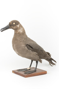 The Beechworth Burke Museum
Animal specimen - Sooty Albatross, Trustees of the Australian Museum, 1860-1880
The Sooty Albatross can be located on islands in the southern Atlantic Ocean and the Indian Ocean. It is a colonial bird with colonies consisting of 50 to 60 pairs of birds. These birds will build nests on cliffs and steep slopes. The diet of the Sooty Albatross includes squid, crustaceans, cephalopods, fish and carrion. They are considered an endangered species by the IUCN with a population shrinkage of over 75% over the last 90 years. In the 21st century, the population of this Albatross has seen stability on Gough Island. Interestingly, this species have several features which make them unique. They have nasal passages attached to their upper bill called naricorns and can produce a stomach oil which is stored by the bird and used against predators as well as being food for their chicks. These birds also have a salt gland which helps desalinate their bodies after residing in salt water. This specimen is part of a collection of almost 200 animal specimens that were originally acquired as skins from various institutions across Australia, including the Australian Museum in Sydney and the National Museum of Victoria (known as Museums Victoria since 1983), as well as individuals such as amateur anthropologist Reynell Eveleigh Johns between 1860-1880. These skins were then mounted by members of the Burke Museum Committee and put-on display in the formal space of the Museum’s original exhibition hall where they continue to be on display. This display of taxidermy mounts initially served to instruct visitors to the Burke Museum of the natural world around them, today it serves as an insight into the collecting habits of the 19th century.This specimen is part of a significant and rare taxidermy mount collection in the Burke Museum. This collection is scientifically and culturally important for reminding us of how science continues to shape our understanding of the modern world. They demonstrate a capacity to hold evidence of how Australia’s fauna history existed in the past and are potentially important for future environmental research. This collection continues to be on display in the Museum and has become a key part to interpreting the collecting habits of the 19th century.This Sooty Albatross specimen is of medium size and mainly a sooty-brown plumage. The colouring around the sides of the head and the base of the tail is dark. It has a dark bill which is medium in size and has been stylized with glass eyes by the taxidermist. The tail is a wide diamond-shape and the feet are webbed. This specimen has been placed on a wooden mount and has a small paper identification tag tied to its right leg.Sooty Albatross / 13D / Catalogue Page 49 /taxidermy mount, taxidermy, animalia, burke museum, beechworth, australian museum, skin, reynell eveleigh johns, bird, hawk-owl, europe, atlantic ocean, indian ocean, albatross, sooty albatross, endangered species -
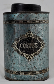 Kiewa Valley Historical Society
Tin Coffee Cylindrical, circa mid to late 1900's
This "coffee" tin has by the "art deco" appearance its origins in the late 1950's to 1960's. This time period was one of accelerated growth both in the physical (housing) sense and the mental (new ideas and inventions) changes in "attitudes". These occurred more rapidly in cities but had its effects on the rural environment. The drinking of coffee was spurred on by easier distribution of imported food and drinks. Advertising by stronger radio links and then by television brought the variety of foods and drinks to semi isolated rural regions. The accessibility through greater information channels becoming available brought with it unbelievable ranges of goods and foodstuffs. Rural regions still relied on bulk supplies and relatively larger storage containers than those in cities. This "bulk" buying and storage "syndrome" was a lingering result of many years of "drought" periods when road transports met delays from flooded roadways in supplying population centres in the Kiewa Valley. The construction phases in building the SEC Vic Hydro electricity Scheme in the eastern sections of the Victorian Alps brought many changes to the quiet rural regions in the Kiewa Valley. Changes in population and social mores. The influx of a varied , mostly temporary, and "European flavoured cuisine" changes the "cuppa tea only" flavour to the have a "coffee break". The subliminal influence of the "American" films changed those children growing up in the post 1950s from the "English tea" to the "American coffee". This "Americanisation process has influenced not only rural Australia but also other areas throughout the world.This "insignificant" coffee tin is very significant as it demonstrates that the Kiewa Valley was becoming more accessible to reliable coffee supplies and general food items.The container was part of a "set" of containers that included tea, sugar,biscuits,flour, rice and other family condiments. This type of kitchen storage containers was brought about through changing patterns in tea and coffee useage and overall consumption. Household demands for faster "self help" cooking especially beveridges and the greater choice of kitchen "utensils" was brought on by easier access to products due to a lessening of the area's "isolation" by having a reliable (all weather) road system and an ever increasing population growth. The need for travelling goods/merchant supply caravans to service the area became a diminishing factor, as a result of the establishment of grocery stores in Tawonga and Mount Beauty in the supply of previously "hard to get" groceries. This transition was precipitated by the SEC Vic Hydro Scheme of the 1940's to 1960's which increased the valley's population level three fold.This cylindrical tin has a pull/push lid(for easy access to the contents). The container is labelled for "coffee" however it has no commercial manufacturer's label to establish that it was bought with coffee ingredients in it. The majority of the container's external surface has a "metallic" light blue colour with two sets of silver rings confining black (horizontal spotted) rectangles. "COFFEE" within an elongated spherical "art deco" four pointed banner of silver and black colouringkitchen containers, domestic food storage, bulk stocks of dried condiments -
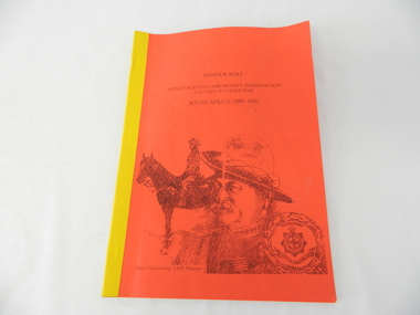 Kiewa Valley Historical Society
Book - Non Fiction History, Honour Roll - South Africa 1899 - 1902 Albury-Wodonga and District Residents Who Served In The Boer War, reprinted 03/2008
Historical information of soldiers from the Albury-Wodonga district who fought in the Boer War in South Africa 1899 - 1902. In 1996 the then curator for the 8/13 VMR Museum, the Hon Colonel John Neale, commissioned the author to research a group of returned servicemen and women from the Boer War and had lived within 100 km radius of the Albury/Wodonga townships.The Boer War was the second war in South Africa and was the result of heavy taxes and non voting rights of the local white Boer population. Colonial forces including the Australian Light Horse contingent where called upon by England to overthrow the rebellion. This War was the first engagement of Australian troops fighting on foreign soil.This Honour Roll details the pay rates, the battle highlights, weapons used and maps covering the first Australian contingent of soldiers who fought in the Transvaal (Boer War).. Listed are the names of those soldiers who lived within 100klms of Albury and Wodonga.The soldiers are listed by Location, Rank, Initial,Name and Unit. The significance of both the War and those who served in it is two fold. Firstly it demonstrates that the tie between the Colonial outreaches of England's Empire to "the Motherland" were extremely strong at this point in time. This union remained strong up until the middle of World War II when England could not help Australia to defend itself against possible invasion by Japan. The alliance between Australia and the United States of America replaced the British/Australian pact. Secondly the attitude of, and the high degree of horsemanship of those from the Albury and Wodonga area. The degree of adaptability, by these servicemen, to suit the environment in which they fought provided the first real insight into the Australian psyche "of those living and surviving on the harsh Australian outback"This book has a bright red soft cover and is bound with bright yellow tape. There is a drawing of two Australian soldiers on the front, one on horsebackAuthor's complimentary inscription "To Mount Beauty Museum with compliments" signed Ian R Docking history, boer war, ex-servicemen and women, albury and wodonga